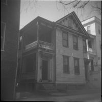
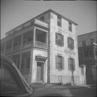
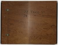
Compilation of original deeds, titles, and other documents related to the transfer, sale, and ownership of the double tenement at 72-74 Tradd Street, known as the Fotheringham-McNeil Tenements. Documents span from 1765 to 1961, likely representing the entire history of the ownership of the double tenement throughout that time period. Also includes blueprints and photographs. (NOTE: Fotheringham has also been spelled Fotheringham.)
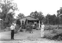
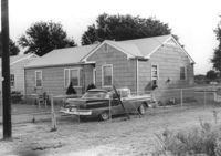
House on site affected by the construction of Interstate 26 (I-26). Sign posted in ground: Worms for sale. Surveyor notations on back of photo: "Dkt.: 10.471. Property owner: F.R. Shutt, et al. Tract: 92. Station: 5376+10 Rt. Date: Aug. 23, 1960. In R/W - Bought." [See collection description for explanation of surveyor notations.]
House on site affected by the construction of Interstate 26 (I-26). Surveyor notations on back of photo: "Dkt.: 10.471. Property owner: W.L. McDonald, et al. Tract: 38. Station: 5326+00 Rt. Date: Aug. 23, 1960. In R/W - Bought." [See collection description for explanation of surveyor notations.]
House on site affected by the construction of Interstate 26 (I-26). Surveyor notations on back of photo: "Dkt.: 10.471. Property owner: Isabella W. Meany. Tract: 98. Station: 5378+80 Rt. Date: Aug. 23, 1960. In R/W - Bought." [See collection description for explanation of surveyor notations.]
House on site affected by the construction of Interstate 26 (I-26). Surveyor notations on back of photo: "Dkt.: 10.471. Property owner: Annie L. Beattie. Tract: 83. Station: 5364+00 Rt. Date: Aug. 23, 1960. In R/W - Bought." [See collection description for explanation of surveyor notations.]
House on site affected by the construction of Interstate 26 (I-26). Surveyor notations on back of photo: "Dkt.: 10.471. Property owner: E.T. Walling. Tract: 39. Station: 5324+30 Lt. Date: Aug. 23, 1960. In R/W - Bought." [See collection description for explanation of surveyor notations.]
House on site affected by the construction of Interstate 26 (I-26). Surveyor notations on back of photo: "Dkt.: 10.471. Property owner: J.E. Walling. Tract: 41. Station: 5325+15 Rt. Date: Aug. 23, 1960. In R/W - Bought." [See collection description for explanation of surveyor notations.]
House on site affected by the construction of Interstate 26 (I-26). Surveyor notations on back of photo: "Dkt.: 10.471. Property owner: R.B. Evans. Tract: 2. Station: 5155+75 Lt. Date: Aug. 23, 1960. Proximity." [See collection description for explanation of surveyor notations.]
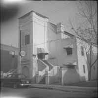
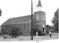
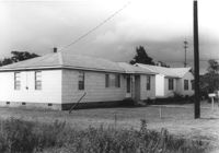
Mid Park Methodist Church, on site affected by the construction of Interstate 26 (I-26). Surveyor notations on back of photo: "Dkt.: 10.471. Property owner: Mid Park Meth. Church. Tract: 102. Station: 5376+50 Rt. Date: Aug. 23, 1960. Proximity." [See collection description for explanation of surveyor notations.]
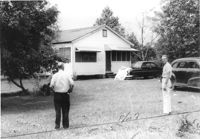
House on site affected by the construction of Interstate 26 (I-26). Building address number 22 (painted on mailbox). Surveyor notations on back of photo: "Dkt.: 10.471. Property owner: Eleanor L. O'Brien. Tract: 105. Station: 5379+50 Lt. Date: Aug. 23, 1960. Proximity." [See collection description for explanation of surveyor notations.]
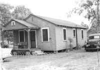
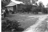
House, and Fuller's Grocery, on site affected by the construction of Interstate 26 (I-26). Surveyor notations on back of photo: "Dkt.: 10.471. Property owner: H.L. Fuller. Tract: 103. Station: 28+00 Lt. (Midland Park Road). Date: Aug. 23, 1960. Proximity." [See collection description for explanation of surveyor notations.]
House on site affected by the construction of Interstate 26 (I-26). Surveyor notations on back of photo: "Dkt.: 10.471. Property owner: Katie S. Smith. Tract: 37. Station: 5323+80 Lt. Date: Aug. 23, 1960. In R/W - Bought." [See collection description for explanation of surveyor notations.]
House on site affected by the construction of Interstate 26 (I-26). Surveyor notations on back of photo: "Dkt.: 10.471. Property owner: Mamie W. Brown. Tract: 91. Station: 5376+15 Rt. Date: Aug. 23, 1960. In R/W - Bought." [See collection description for explanation of surveyor notations.]
House on site affected by the construction of Interstate 26 (I-26). Surveyor notations on back of photo: "Dkt.: 10.471. Property owner: M.L. Shipman, et al. Tract: 42. Station: 5326+75 Rt. Date: Aug. 23, 1960. Proximity." [See collection description for explanation of surveyor notations.]
House on site affected by the construction of Interstate 26 (I-26). Surveyor notations on back of photo: "Dkt.: 10.471. Property owner: W.W. Gregory. Tract: 46. Station: 5329+60 Rt. Date: Aug. 23, 1960. Proximity." [See collection description for explanation of surveyor notations.]
House on site affected by the construction of Interstate 26 (I-26). Surveyor notations on back of photo: "Dkt.: 10.471. Property owner: Annie C. Craven. Tract: 116. Station: 5396+10 Rt. Date: Aug. 23, 1960. In R/W - Bought." [See collection description for explanation of surveyor notations.]
House on site affected by the construction of Interstate 26 (I-26). Surveyor notations on back of photo: "Dkt.: 10.471. Property owner: Annie C. Craven. Tract: 116. Station: 5396+10 Rt. Date: Aug. 23, 1960. In R/W - Bought." [See collection description for explanation of surveyor notations.]
House on site affected by the construction of Interstate 26 (I-26). Surveyor notations on back of photo: "Dkt.: 10.471. Property owner: Noble M. Drennen. Tract: 104. Station: 5379+30 Lt. Date: Aug. 23, 1960. Proximity." [See collection description for explanation of surveyor notations.]
House on site affected by the construction of Interstate 26 (I-26). Surveyor notations on back of photo: "Dkt.: 10.471. Property owner: Ruth H. Snipes. Tract: 40. Station: 5323+50 Rt. Date: Aug. 23, 1960. Proximity." [See collection description for explanation of surveyor notations.]
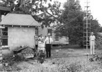
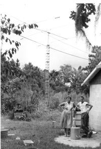
Lot with tall mast, on site affected by the construction of Interstate 26 (I-26). Surveyor notations on back of photo: "Dkt.: 10.471. Property owner: W.W. Gregory. Tract: 46. Station: 5330+00 Rt. Date: Aug. 23, 1960. Owner to move mast." [See collection description for explanation of surveyor notations.]
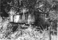
House (rear view) on site affected by the construction of Interstate 26 (I-26). Surveyor notations on back of photo: "Dkt.: 10.471. Property owner: Andrew J. Hovanec. Tract: 154. Station: 5485+50 Lt. Date: Aug. 23, 1960. Proximity." [See collection description for explanation of surveyor notations.]
House on site affected by the construction of Interstate 26 (I-26). Surveyor notations on back of photo: "Dkt.: 10.471. Property owner: L. Pellatiro. Tract: 149. Station: 5282+60 Lt. Date: Aug. 23, 1960. In R/W - Bought." [See collection description for explanation of surveyor notations.]
House on site affected by the construction of Interstate 26 (I-26). Surveyor notations on back of photo: "Dkt.: 10.471. Property owner: W.R. Wren. Tract: 148. Station: 5482+00 Lt. Date: Aug. 23, 1960. In R/W - Bought." [See collection description for explanation of surveyor notations.]
House on site affected by the construction of Interstate 26 (I-26). Surveyor notations on back of photo: "Dkt.: 10.471. Property owner: T.M. Evans. Tract: 145. Station: 5481+10 Lt. Date: Aug. 23, 1960. In R/W - Bought." [See collection description for explanation of surveyor notations.]
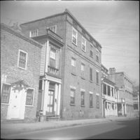
Looking east on Wentworth Street from 26 Wentworth Street (Gardner Kitchen House). Features (left to right): 26 Wentworth Street, 22-24 Wentworth Street (Francis Q. McHugh Tenements), 18-20 Wentworth Street, and 14 Wentworth Street.
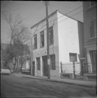
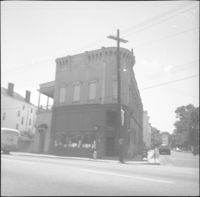
309 East Bay Street (Watson's Grocery), located at the southwest corner of East Bay and Laurens Street, before demolition. (The house at 116 Anson Street was moved to this site with the current address 39 Laurens Street.)
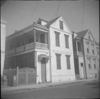
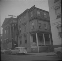
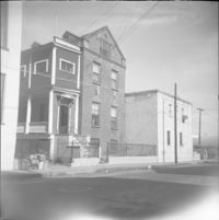
57 Society Street (William McElheran House), flanked by 55 Society Street (High School of Charleston) (left) and partial view of 59 Society Street (right).
Looking east on George Street to where it ended at Anson Street before the continuation of George Street occurred. Left to right: What was 86 Anson Street, later relocated to 82 Anson Street, and the original house at 82 Anson Street, later demolished for the relocation of 86 Anson Street.
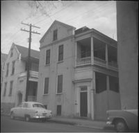
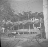
59 Society Street, flanked to its left by 55 Society Street (High School of Charleston) and 57 Society Street (William McElheran House), and to its right by 61 Society Street.


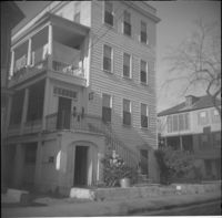
![116 Anson Street [now at 39 Laurens Street]](https://iiif.library.cofc.edu/iiif/2/48432/full/200,/0/default.jpg)