Search
« Previous |
501 - 600 of 1,613
|
Next »
Search Results
Date:
1977-1983
Description:
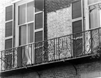
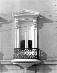
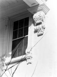
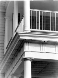
9 East Battery, Roper House, ca. 1842. Detail View of balcony. 1st Floor, East (Front) elevation. 4" x 5" B/W photo.
Date:
1977-1983
Description:
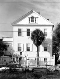
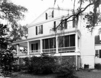
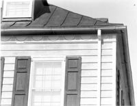
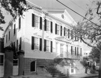
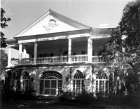
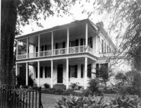
69 Barre Street, Gov. Thomas Bennett House, ca. 1822. Main House - View of East (Front) elevation. 4" x 5" B/W photo.
Date:
1977-1983
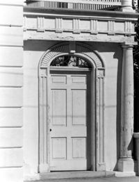
Description:
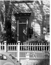
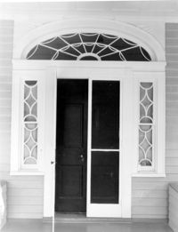
19 Archdale Street, Philip Porcher House, ca. 1765. Detail View of entry, East (Front) elevation. 4" x 5" B/W photo.
Date:
1977-1983
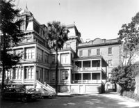
Description:
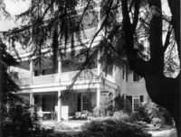
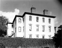
34 Meeting Street, Daniel Elliott Huger House, ca. 1759. Main House - View of South (Side) elevation. 4" x 5" B/W photo.
Date:
1977-1983
Description:
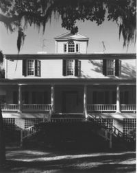
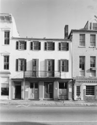
76 Church Street, Dubose Heyward House, ca.1785. View of SW (Front and Side) elevation. 4" x 5" B/W photo.
Date:
1977-1983
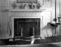
Description:
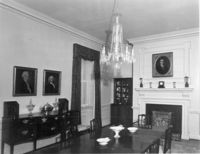
34 Meeting Street, Daniel Elliott Huger House, ca. 1759. Main House - Interior View. 1st Floor - SE Room, South and West walls. 4" x 5" B/W photo.
Date:
1977-1983
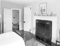
Description:
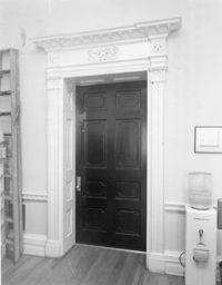
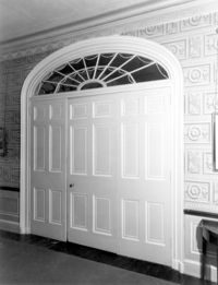
14 George Street, Middleton-Pinckney House, ca. 1796. Interior View - 2nd Floor. Detail of door, hall to NW room. 4" x 5" B/W photo.
Date:
1977-1983
Description:
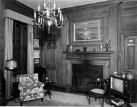
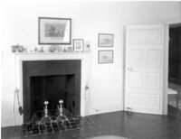
34 Meeting Street, Daniel Elliott Huger House, ca. 1759. Main House - Interior View. 1st Floor - NW Room, East wall. 4" x 5" B/W photo.
Date:
1977-1983
Description:
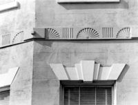
14 George Street, Middleton-Pinckney House, ca. 1796. Detail View of 2nd Floor string course and window cornice. 4" x 5" B/W photo.
Date:
1977-1983
Description:
14 George Street, Middleton-Pinckney House, ca. 1796. View of North (Rear) elevation. 4" x 5" B/W photo.
Date:
1977-1983
Description:
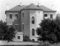
Georgetown County, Chicora Wood Plantation, ca. 1819. Main House - View of East (Side) elevation. 4" x 5" B/W photo.
Date:
1977-1983
Description:
Georgetown County, Chicora Wood Plantation, ca. 1819. Main House - View of South (Front) elevation. 4" x 5" B/W photo.
Date:
1977-1983
Description:
Charleston County, William Seabrook-Dodge Plantation, ca. 1810. Interior View. 1st Floor - Hall, Detail of door to SW Room. 4" x 5" B/W photo.
Date:
1977-1983
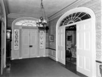
Description:
Charleston County, William Seabrook-Dodge Plantation, ca. 1810. Interior View. 1st Floor - Hall, looking South to entry. 4" x 5" B/W photo.
Date:
1977-1983
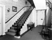
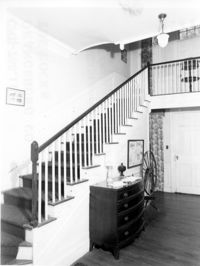
Description:
Charleston County, William Seabrook-Dodge Plantation, ca. 1810. Interior View. 1st Floor - Hall, Detail of stairway. 4" x 5" B/W photo.
Date:
1977-1983
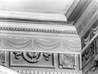
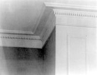
Description:
Charleston County, William Seabrook-Dodge Plantation, ca. 1810. Interior View. 1st Floor - Hall, Detail of cornice. 4" x 5" B/W photo.
Date:
1977-1983
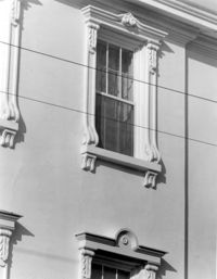
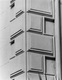
Description:
93 Rutledge Avenue, Seabrook-Trenholm House, ca. 1819. Detail View of 2nd Floor windows, East (Front) elevation. 4" x 5" B/W photo.
Date:
1977-1983
Description:
81 Rutledge Avenue, Glover-Sottile House, ca. 1826. Detail View of 1st Floor window, East (Front) elevation. 4" x 5" B/W photo.
Date:
1977-1983
Description:
185 Rutledge Avenue, Thomas Doughty House, ca. 1798. Detail View of cornice. 4" x 5" B/W photo.
Date:
1977-1983
Description:
33 Broad Street, John Smith House, ca. 1785. View of North (Front) elevation. 4" x 5" B/W photo.
Date:
1977-1983
Description:
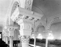
146 Church Street, St. Philip's Episcopal Church, ca. 1836. Interior View - Detail of balcony column capitals, NE (Rear and Side) elevation 4" x 5" B/W photo.
Date:
1977-1983
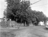
Description:
48 Elizabeth Street, Aiken-Rhett House, ca.1818. Complex - View of fence, West (Side) elevation. 4" x 5" B/W photo.
Date:
1977-1983
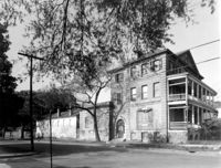
Description:
48 Elizabeth Street, Aiken-Rhett House, ca.1818. Complex - View of SW (Side and Front) elevation. 4" x 5" B/W photo.
Date:
1977-1983
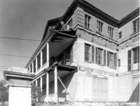
Description:
48 Elizabeth Street, Aiken-Rhett House, ca.1818. Main House - View of SE (Front and Side) elevation. 4" x 5" B/W photo.
Date:
1977-1983
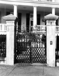
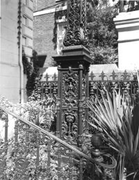
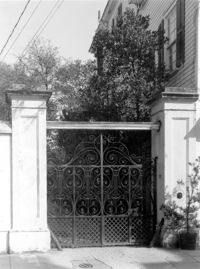
Description:
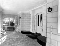
20 South Battery, Stevens-Lathers House, ca. 1843. Main House - Detail View of entry gate, South (Front) elevation. 4" x 5" B/W photo.
Date:
1977-1983
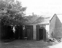
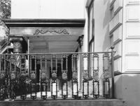
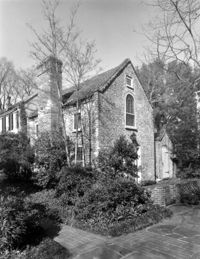
Description:
8 South Battery, Colonel William Washington House, ca. 1768. Stable - View of SE (Front) elevation. 4" x 5" B/W photo.
Date:
1977-1983
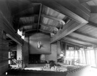
Description:
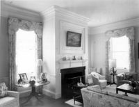
Beaufort County, Auldbrass Plantation, ca. 1951. Main House - Interior View. Living Room, looking South. 4" x 5" B/W photo.
Date:
1977-1983
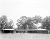
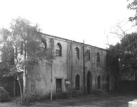
Description:
Beaufort County, Auldbrass Plantation, ca. 1951.Main House - View of East elevation. 4" x 5" B/W photo.
Date:
1977-1983
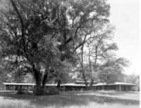
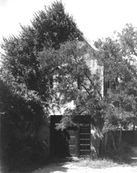
Description:
Beaufort County, Auldbrass Plantation, ca. 1951. Main House - View of NE elevation. 4" x 5" B/W photo.
Date:
1977-1983
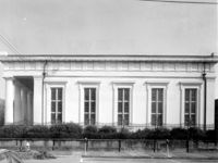
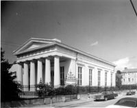
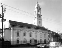
Description:
90 Hasell Street, Synagogue of Kahal Kadosh Beth Elohim, ca. 1840. View of South (Side) elevation. 4" x 5" B/W photo.
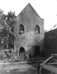
Date:
1977-1983
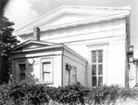
Description:
90 Hasell Street, Synagogue of Kahal Kadosh Beth Elohim, ca. 1840. View of East (Rear) elevation. 4" x 5" B/W photo.
Date:
1977-1983
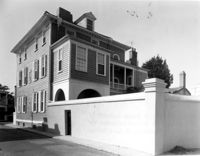
Description:
106 Tradd Street, Colonel John Stuart House, ca. 1772. Main House - View of NE (Rear and Side) elevation. 4" x 5" B/W photo.
Date:
1977-1983
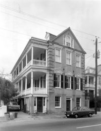
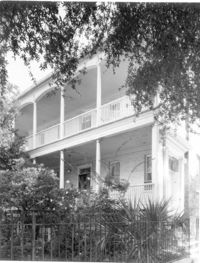
Description:
95 Rutledge Avenue, Grimke-Seabrook House, ca. 1819. View of SE (Front and Side) elevation. 4" x 5" B/W photo.
Date:
1977-1983
Description:
Georgetown County, Arcadia Plantation, ca. 1794. Interior View - 1st Floor, SW room. 4" x 5" B/W photo.
Date:
1977-1983
Description:
Georgetown County, Cat Island Plantation. View of NE (Front and Side) elevation. 4" x 5" B/W photo.
Date:
1977-1983
Description:
Beaufort County, Auldbrass Plantation, ca. 1951. Kennels, Stable, Covered Entry and Gate House (From Left to Right) - View of East elevation. 4" x 5" B/W photo.
Date:
1977-1983
Description:
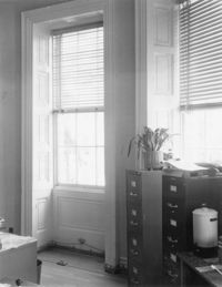
14 George Street, Middleton-Pinckney House, ca. 1796. Interior View - Detail of window. Representative of windows on the 1st and 2nd floors. 4" x 5" B/W photo.
Date:
1977-1983
Description:
64 South Battery, William Gibbes House, ca. 1772. Main House - View of SW (Front and Side) elevation. 4" x 5" B/W photo.
Date:
1977-1983
Description:
St. Margaret, West End, William Lowndes House, date unknown. View of South (Front) elevation. 4" x 5" B/W photo.
Date:
1977-1983
Description:
116 Broad Street, John Rutledge House, ca. 1763. Main House - View of West (Side) elevation. 4" x 5" B/W photo.
Date:
1977-1983
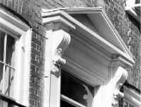
Description:
93 Rutledge Avenue, Seabrook-Trenholm House, ca. 1819. Detail View of console and 2nd Floor windows, South (Side) elevation. 4" x 5" B/W photo.
Date:
1977-1983
Description:
116 Broad Street, John Rutledge House, ca. 1763. Main House - Detail View of portico support, South (Front) elevation. 4" x 5" B/W photo.
Date:
1977-1983
Description:
116 Broad Street, John Rutledge House, ca. 1763. Main House - Detail View of portico and railing, West (Side) elevation. 4" x 5" B/W photo.
Date:
1977-1983
Description:
116 Broad Street, John Rutledge House, ca. 1763. Carriage House (ca. 1853) - View of SE (Side and Front) elevation. 4" x 5" B/W photo.
Date:
1977-1983
Description:
116 Broad Street, John Rutledge House, ca. 1763. Carriage House (ca. 1853) - View of South (Front) elevation. 4" x 5" B/W photo.
Date:
1977-1983
Description:
116 Broad Street, John Rutledge House, ca. 1763. Carriage House (ca. 1853) - View of North (Rear) elevation. 4" x 5" B/W photo.
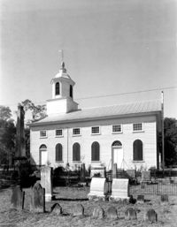
Date:
1977-1983
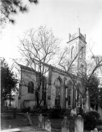
Description:
Charleston County, Edisto Island Presbyterian Church, ca. 1831. Church - View of North (Rear) elevation. 4" x 5" B/W photo.
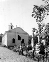
Date:
1977-1983
Description:
Charleston County, Edisto Island Presbyterian Church, ca. 1831. Church - View of East (Side) elevation. 4" x 5" B/W photo.
Date:
1977-1983
Description:
635 East Bay Street, Faber-Ward House, ca. 1832. Main House and Complex - View of North (Side) elevation 4" x 5" B/W photo.
Date:
1977-1983
Description:
31 Legare Street, Hannah Heyward House, ca. 1789. Main House - View of NE (Rear and Side) elevation. 4" x 5" B/W photo.
Date:
1977-1983
Description:
31 Legare Street, Hannah Heyward House, ca. 1789. Main House - View of East (Front) elevation. 4" x 5" B/W photo.
Date:
1977-1983
Description:
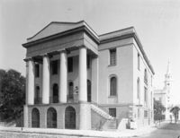
100 Meeting Street, Fireproof Building, ca. 1822. View of NW (Front and Side) elevation 4" x 5" B/W photo.
Date:
1977-1983
Description:
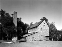
Georgetown County, Chicora Wood Plantation, ca. 1819. Rice Threshing Mill with Chimney Stack - View of SW (front and Side) elevation. 4" x 5" B/W photo.
Date:
1977-1983
Description:
116 Broad Street, John Rutledge House, ca. 1763. Main House - Detail View of sheet metal quoining, SW (Front and Side) corner. 4" x 5" B/W photo.
Date:
1977-1983
Description:
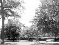
Beaufort County, Auldbrass Plantation, ca. 1951. Gate House, Covered Entry, Stable, Passages and Kennels - View of West elevation. 4" x 5" B/W photo.
Date:
1977-1983
Description:
116 Broad Street, John Rutledge House, ca. 1763. Main House - Detail View of cornice and windows, SW (Front and Side) elevation. 4" x 5" B/W photo.
Date:
1977-1983
Description:
20 Montague Street, Cobia-Moultrie House, ca. 1808. Main House - View of West (Side) elevation. 4" x 5" B/W photo.
Date:
1977-1983
Description:
20 Montague Street, Cobia-Moultrie House, ca. 1808. Main House - View of South (Front) elevation. 4" x 5" B/W photo.
Date:
1977-1983
Description:
90 Hasell Street, Synagogue of Kahal Kadosh Beth Elohim, ca. 1840. View of SW (Front and Side) elevation. 4" x 5" B/W photo.
Date:
1977-1983
Description:
18 Bull Street, William Blacklock House, ca. 1800. Main House - Interior View. 1st Floor - SW Room, showing arches. 4" x 5" B/W photo.
Date:
1977-1983
Description:
18 Bull Street, William Blacklock House, ca. 1800. Main House - Interior View. 1st Floor - Stair Hall, looking Up. 4" x 5" B/W photo.
Date:
1977-1983
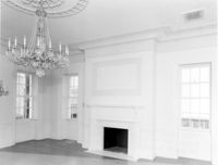
Description:
456 King Street, William Aiken House, ca. 1811. Main House - Interior View. 1st Floor - West Room, North wall. 4" x 5" B/W photo.
Date:
1977-1983
Description:
456 King Street, William Aiken House, ca. 1811. Main House - Interior View. 1st Floor - Ballroom, looking SE 4" x 5" B/W photo.
Date:
1977-1983
Description:
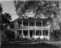
69 Barre Street, Gov. Thomas Bennett House, ca. 1822. Main House - View of NE (Front and Side) elevation. 4" x 5" B/W photo.
Date:
1977-1983
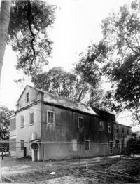
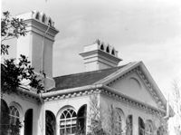
Description:
69 Barre Street, Gov. Thomas Bennett House, ca. 1822. Dependency - View of NE (Front and Side) elevation. 4" x 5" B/W photo.
Date:
1977-1983
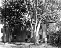
Description:
69 Barre Street, Gov. Thomas Bennett House, ca. 1822. Dependency - View of NW (Front and Side) elevation. 4" x 5" B/W photo.
Date:
1977-1983
Description:
Charleston County, William Seabrook-Dodge Plantation, ca. 1810. Detail View of main entry on 1st Floor, South (Front) elevation. 4" x 5" B/W photo.
Date:
1977-1983
Description:
Charleston County, William Seabrook-Dodge Plantation, ca. 1810. Detail View of portico (1st Floor) cornice, South (Front) elevation. 4" x 5" B/W photo.
Date:
1977-1983
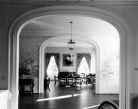
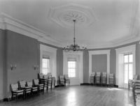
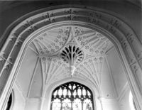
Description:
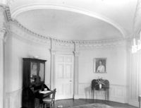
172 Rutledge Avenue, Ashley Hall, ca. 1802. Main House - Interior View. 1st Floor - View of West Double Room, oval East wall and South end of room. 4" x 5" B/W photo.
Date:
1977-1983
Description:
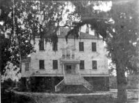
Georgetown County, Arcadia Plantation, ca. 1794. Copy of 1900 photo. View of East (Rear) elevation. 4" x 5" B/W photo.
Date:
1977-1983
Description:
10 Archdale Street, Saint John's Lutheran Church, ca. 1816. View of North (Side) elevation. 4" x 5" B/W photo.
Date:
1977-1983
Description:
6 Archdale Street, Unitarian Church, ca. 1787. Interior View - Altar pendant. 4" x 5" B/W photo.
Date:
1977-1983
Description:
6 Archdale Street, Unitarian Church, ca. 1787. View of NE (Side and Rear) elevation. 4" x 5" B/W photo.
Date:
1977-1983
Description:
95 - 103 East Bay Street, Rainbow Row, ca. 1740. View of East (Front) elevation. 4" x 5" B/W photo.
Date:
1977-1983
Description:
Orangeburg County, Rocks Plantation (The Rocks), ca. 1805. Main House - Interior View. 1st Floor - Stair Hall, West and North walls. 4" x 5" B/W photo.
Date:
1977-1983
Description:
Camden Depot of the S.C.R.R., ca. 1845; South side of Ann Street between Meeting and King Streets. Attributed to E.B. White, architect. View of entry with NW pier detail from the NE. 4" x 5" B/W photo.
Date:
1977-1983
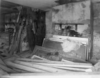
Description:
86 Church Street, Isaac Mazyck House, ca. 1783. North Dependency - Interior View. Kitchen - North wall from East entry on South side. 4" x 5" B/W photo.
Date:
1977-1983
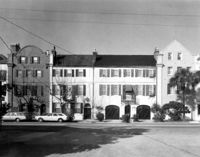
Description:
2 - 4 Court House Square, Daniel Blake Tenements, ca. 1760. Detail View of entry (#4) transom and cornice, South (Front) elevation. 4" x 5" B/W photo.
Date:
1977-1983
Description:
10 Judith Street, John Robinson House, ca. 1814. Kitchen House - Interior View. 1st Floor - North room, NW elevation. 4" x 5" B/W photo.
Date:
1977-1983
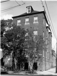
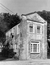
Description:
94 Rutledge Avenue, Isaac Jenkins Mikell House, ca. 1851. Kitchen building - SW (Front and Side) elevation. 4" x 5" B/W photo.
Date:
1977-1983
Description:
Berkley County, Mulberry Plantation, ca. 1714. Main House - Interior View. 1st Floor - SE Room. Detail of cornice. 4" x 5" B/W photo.
Date:
1977-1983
Description:
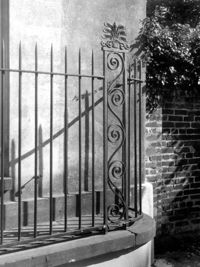
8 Legare Street, Cleland and Kinloch Huger House , ca.1858. Detail View of wrought iron gate. 4" x 5" B/W photo.
Date:
1977-1983
Description:
172 Rutledge Avenue, Ashley Hall, ca. 1802. Main House - Detail View of pediment, East (Side) elevation. 4" x 5" B/W photo.
Date:
1977-1983
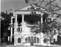
Description:
172 Rutledge Avenue, Ashley Hall, ca. 1802. Main House - View of South (Front) elevation. 4" x 5" B/W photo.
Date:
1977-1983
Description:
58 Hasell Street (formerly 54 Hasell Street, Colonel William Rhett House), ca. 1712. View of SW (Side and Front) elevation. Original Dependency of 54 Hasell. 4" x 5" B/W photo.
Date:
1977-1983
Description:
56 Hasell Street (formerly 54 Hasell Street, Colonel William Rhett House), ca. 1712. View of South (Front) elevation. Original Dependency of 54 Hasell. 4" x 5" B/W photo.
Date:
1977-1983
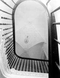
Description:
172 Rutledge Avenue, Ashley Hall, ca. 1802. Main House - Interior View. Ground Floor - Detail of staircase, looking Up. 4" x 5" B/W photo.
Date:
1977-1983
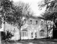
Description:
172 Rutledge Avenue, Ashley Hall, ca. 1802. Main House - View of Ground Floor portico and entry, South (Front) elevation. 4" x 5" B/W photo.
Date:
1977-1983
Description:
172 Rutledge Avenue, Ashley Hall, ca. 1802. Main House - Detail View of wrought iron fence, North (Rear) elevation. 4" x 5" B/W photo.
Date:
1977-1983
Description:
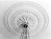
48 Elizabeth Street, Aiken-Rhett House, ca.1818. Main House - Interior View. 1st Floor - East Room. Detail of ceiling medallion. 4" x 5" B/W photo.
Date:
1977-1983
Description:
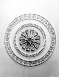
48 Elizabeth Street, Aiken-Rhett House, ca.1818. Main House - Interior View. 1st Floor - SW Room. Detail of ceiling medallion. 4" x 5" B/W photo.
Date:
1977-1983
Description:
456 King Street, William Aiken House, ca. 1811. Main House - Detail View of Ground Floor entry, West (Front) elevation. 4" x 5" B/W photo.
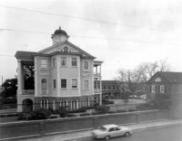
Date:
1977-1983
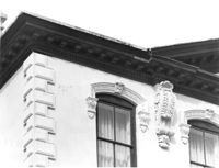
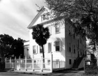
Description:
147 Wentworth Street, Francis Silas Rodgers Mansion, ca.1886. Main House - View of South (Rear) elevation - East end of house. 4" x 5" B/W photo.
Date:
1977-1983
Description:
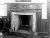
64 South Battery, William Gibbes House, ca. 1772. Main House - Interior. 1st Floor - SE Room, Detail of mantle. 4" x 5" B/W photo.
Date:
1977-1983
Description:
Berkley County, Mulberry Plantation, ca. 1714. Main House - Interior View. 2nd Floor - NW Room, South wall. 4" x 5" B/W photo.
Date:
1977-1983
Description:
Berkley County, Mulberry Plantation, ca. 1714. Main House - Interior View. 2nd Floor - NE Room, South wall. 4" x 5" B/W photo.
Date:
1977-1983
Description:
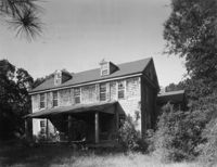
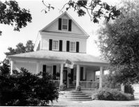
Berkley County, Stephen Williams House, ca. 1842. View of North (Front) elevation. 4" x 5" B/W photo.
Date:
1977-1983
Description:
2 Amherst Street, Christopher Belser House, ca. 1804. Interior View - 1st Floor, SW Wall, Detail of mantle. 4" x 5" B/W photo.
Date:
1977-1983
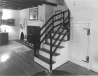
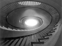
Description:
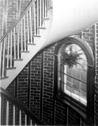
2 Amherst Street, Christopher Belser House, ca. 1804. Interior View - Stair Tower, Detail of spiral stair. 4" x 5" B/W photo.
Date:
1977-1983
Description:
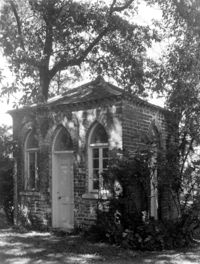
18 Bull Street, William Blacklock House, ca. 1800. Privy [Office] - View of SE (Front and Side) elevation. 4" x 5" B/W photo.