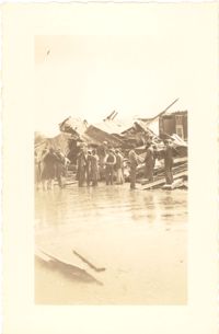
Photograph of wooden building demolished by the first tornado of September 29, 1938. The photograph is marked with a small green X to show the location of the body of a man killed by the tornado. Handwritten on back of photo: "1st tornado came in by Battery near Miller's junk yard - Laurence [Laurens?] Street. This shed is on top of small Negro house. The Negro was dead when found. Sept. 29, '38."
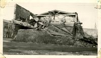
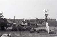
Photograph of the Viohl Hay & Grain warehouse demolished by the tornado of September 29, 1938. Located at the northwest corner of Vendue Range and Concord Street (address 14 Vendue Range). Portion of the building across the street can be seen at left. Steeple of St. Michael's Church in the distance at right. Handwritten on back of photo: "Taken in front of the Clyde Line Steam Ship Co. on Concord Street. Vohls Grain Place. Tornado - Sept. 29, 1938. In distance is St. Michael's Church steeple."
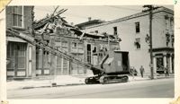
Photograph of the I.M. Pearlstine Building (203 East Bay Street), located on the southwest corner of East Bay Street and Street, after the tornado of September 29, 1938, showing the damage done to the building. Also shows 205 East Bay Street, located on the northwest corner of East Bay and Cumberland. "Bay City" heavy equipment vehicle (excavator?) parked in front of building. Pedestrian and a street worker walking on the sidewalk; repairman on the utility pole on the street corner.
Photograph of the I.M. Pearlstine Building on Cumberland Street, located between East Bay and State Street, after the tornadoes of September 29, 1938, showing the damage done to the building. Portion of signage is visible at the right of the photograph, "I.M." and "Budwe[iser]"; signage for "Rex" is also on building (at left). Onlookers stand among the debris on the street.
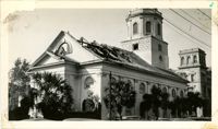
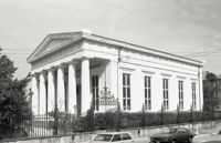
Photograph of First Scots Presbyterian Church [57 Meeting Street] after the tornadoes of September 29, 1938, showing the damage done to the building. The Nathaniel Russell House can be seen in the background. Cars are parked on the street in front of the church.
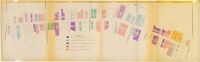
One of four maps of King Street building footprints, hand-colored to designate status. This map illustrates the historical significance of buildings on King Street from Calhoun Street to Queen Street.
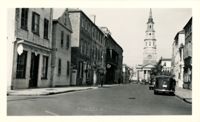
Looking north on Church Street from Chalmers Street. Features buildings on the west side of the street: 127 Church, 129 Church, 131 Church, and the Dock Street Theater). Also in view are buildings on the east side of the street: 18 Chalmers Street, 132 Church Street, and St. Philip's Church). Cars are parked on the street.
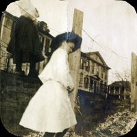
Two young women and field of oyster shells at sea wall on South Battery. William Gibbes House and 68 South Battery are in background. Page 36, Photo 1 of collection. 3.5" x 3.5" B/W photograph, original in two pieces.
Black-and-white photograph of the view north on King Street showing the east side of King Street from 190 King Street (right) and 191 King Street (left). Kerrison's building in the background.
Black-and-white photograph of the view south on Meeting Street from 242 Meeting, showing Anderson Electric Co. (246 Meeting) at right and the Best Western King Charles Hotel (237 Meeting) at left.
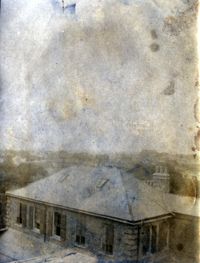
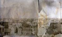
View of Charleston from rooftop of Calhoun Mansion, facing north. Page 3, Photo 2 of collection. 5.5" x 3.75" B/W photograph, two images spliced together.
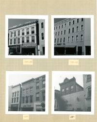
Four B&W photographs of buildings on the east side of King Street, including some that were demolished for the construction of Charleston Place: Top left (244-246): 244 Coastal Finance Loans and 246 King Street (The Linen Shop) demolished; Top right: 238-242 King Street (J.C. Penney Company) ? demolished; Bottom left (226-230): 226 King Street (Ritz [Hotel]), 228 King Street (Little Town), and 230 King Street demolished; Bottom right: 316 King Street (Rosalie Meyers) [labeled 318 on album page].
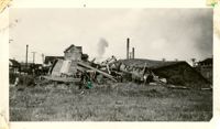
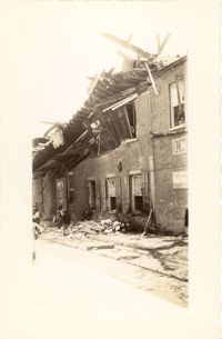
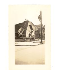
Photograph of the destruction of a house done by the tornadoes of September, 29, 1938. Based on newspaper accounts, the home was probably located in the Fiddlers' Green neighborhood near the Ashley River. Two men lean against the ruins while another man climbs a nearby telephone pole.
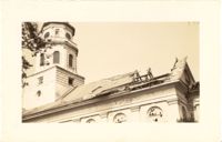
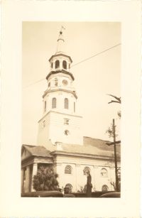
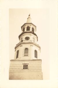
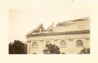
Photograph of St. Michael's Church after the first tornado of September 29, 1938, showing the damage done to the roof. Handwritten on back of photo: "Old historic St. Michael's Church, corner Broad Street and Meeting Street. Done by first tornado, Sept. 29, '38."
Black-and-white photograph of the west side of King Street below Market Street, starting from the southwest corner of King Street and Market Street. South Carolina Federal Savings & Loan (221 King Street) in foreground. Also shown are 219 King Street, 217 King Street, 215 King Street, and 213 King Street. (Currently the site of Majestic Square.)