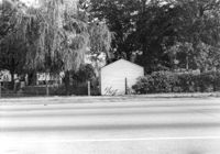
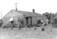
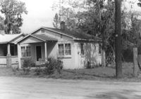
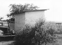
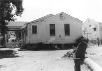
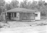
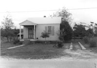
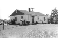
Property and structure (shed?) on Dorchester Road, on site affected by the construction of Interstate 26 (I-26). Surveyor notations on back of photo: "Dkt.: 10.480. Property owner: Frank R. Mangrum. Tract: 176. Station: 131+20 Rt. (Route 642) [Dorchester Road]. Date: May 30, 1961. In R/W - Bought." [See collection description for explanation of surveyor notations.]
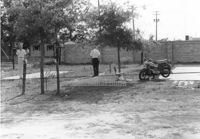
Lot on site affected by the construction of Interstate 26 (I-26). Surveyor notations on back of photo: "Dkt.: 10.480. Property owner: O.H. Julian. Tract: 169. Station: 5680+80 Crosses CL. Date: May 30, 1961. In R/W - Bought." [See collection description for explanation of surveyor notations.]
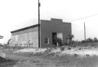
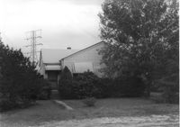
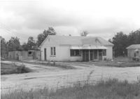
Building (warehouse or other industrial use?) on site affected by the construction of Interstate 26 (I-26). Surveyor notations on back of photo: "Dkt.: 10.480. Property owner: G.S. Carter, Sr. Tract: 162. Station: 5672+00 Lt. CL. Date: May 30, 1961. In R/W - Bought." [See collection description for explanation of surveyor notations.]
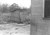
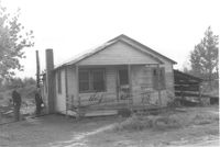
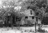
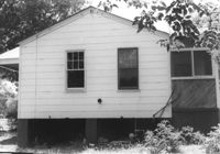
Shed in dilapidated condition on site affected by the construction of Interstate 26 (I-26). Edge of house in foreground. Surveyor notations on back of photo: "Dkt.: 10.480. Property owner: J.L. Spencer, et al. Tract: 50. Station: 5515+30 Lt. Date: May 2, 1961. In R/W - Bought." [See collection description for explanation of surveyor notations.]
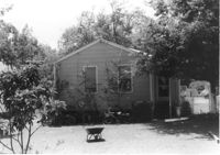
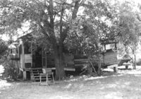
Lot and shed on site affected by the construction of Interstate 26 (I-26). Surveyor notations on back of photo: "Dkt.: 10.480. Property owner: J.M. Fickling. Tract: 281. Station: 5731+50 Lt. (Line B). Date: May 30, 1961. Moving item." [See collection description for explanation of surveyor notations.]
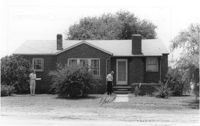
House (corner view, rear) on site affected by the construction of Interstate 26 (I-26). Building address number 31. Surveyor notations on back of photo: "Dkt.: 10.480. Property owner: John A. & Mrs. Sarah H. Meyer. Tract: 293. Station: 5747+85 Lt. Date: May 30, 1961. Proximity." [See collection description for explanation of surveyor notations.]
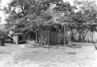
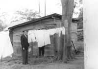
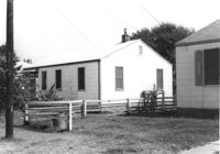
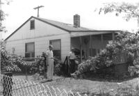
Rear of house and shed, with laundry hanging on clothesline, on site affected by the construction of Interstate 26 (I-26). Surveyor notations on back of photo: "Dkt.: 10.480. Property owner: Ruth I. Kirby. Tract: 236. Station: 5699+30 Lt. Date: May 2, 1961. Shed bought -- proximity to house." [See collection description for explanation of surveyor notations.]
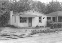
House on site affected by the construction of Interstate 26 (I-26). Building address number 187. "River View." Surveyor notations on back of photo: "Dkt.: 10.480. Property owner: Mary E. Martin. Tract: 261. Station: 5712+75 CL. Date: May 2, 1961. In R/W - Bought." [See collection description for explanation of surveyor notations.]
House (corner view, rear) and backyard, on site affected by the construction of Interstate 26 (I-26). Surveyor notations on back of photo: "Dkt.: 10.480. Property owner: Mrs. Lovie Mae Smith. Tract: 287. Station: 5737+40 Lt. (Line B). Date: May 30, 1961. In R/W - Bought." [See collection description for explanation of surveyor notations.]
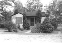
House on site affected by the construction of Interstate 26 (I-26). Partially obscured by trees. Surveyor notations on back of photo: "Dkt.: 10.480. Property owner: Edward P. Blanton. Tract: 146. Station: 5661+30 Rt. Date: May 2, 1961. In R/W - Bought." [See collection description for explanation of surveyor notations.]
House and garage/shed, on site affected by the construction of Interstate 26 (I-26). Surveyor notations on back of photo: "Dkt.: 10.480. Property owner: Frank Jenkins, et al. Tract: 6. Station: 5499+40 Rt. Date: May 2, 1961. In R/W - Bought." [See collection description for explanation of surveyor notations.]
House on site affected by the construction of Interstate 26 (I-26). Surveyor notations on back of photo: "Dkt.: 10.480. Property owner: Leroy Hilton, et al. Tract: 8. Station: 5499+80 Rt. Date: May 2, 1961. In R/W - Bought." [See collection description for explanation of surveyor notations.]
House on site affected by the construction of Interstate 26 (I-26). Surveyor notations on back of photo: "Dkt.: 10.480. Property owner: Robert Watson. Tract: 13. Station: 5502+35 Lt. Date: May 2, 1961. In R/W - Bought." [See collection description for explanation of surveyor notations.]
House on site affected by the construction of Interstate 26 (I-26). Surveyor notations on back of photo: "Dkt.: 10.480. Property owner: Oree McFadden. Tract: 11. Station: 5502+10 Lt. Date: May 2, 1961. In R/W - Bought." [See collection description for explanation of surveyor notations.]
House on site affected by the construction of Interstate 26 (I-26). Driveway leads to garage/shed. Surveyor notations on back of photo: "Dkt.: 10.480. Property owner: Thomas McGough, et al. Tract: 147. Station: 5662+00 Rt. Date: May 1, 1961. In R/W - Bought." [See collection description for explanation of surveyor notations.]
Laundry hanging on clothesline in front of shed, on site affected by the construction of Interstate 26 (I-26). Surveyor notations on back of photo: "Dkt.: 10.480. Property owner: Ruth I. Kirby. Tract: 236. Station: 5699+25 Lt. Date: May 2, 1961. In R/W - Bought." [See collection description for explanation of surveyor notations.]
House on site affected by the construction of Interstate 26 (I-26). Driveway leads to garage/shed. Surveyor notations on back of photo: "Dkt.: 10.480. Property owner: Lewis S. Snipes. Tract: 193. Station: 5687+50 Lt. Date: May 2, 1961. In R/W - Bought." [See collection description for explanation of surveyor notations.]
House (rear view) on site affected by the construction of Interstate 26 (I-26). Surveyor notations on back of photo: "Dkt.: 10.480. Property owner: H.L. DuPuis Jr. Tract: 278. Station: 5728+00 Rt. (Line C). Date: May 31, 1961. In R/W - Bought." [See collection description for explanation of surveyor notations.]
House (rear view) on site affected by the construction of Interstate 26 (I-26). Surveyor notations on back of photo: "Dkt.: 10.480. Property owner: D.T. Browning. Tract: 264. Station: 5714+60 Lt. Date: May 31, 1961. In R/W - Bought." [See collection description for explanation of surveyor notations.]
House (side view?) on site affected by the construction of Interstate 26 (I-26). Surveyor notations on back of photo: "Dkt.: 10.480. Property owner: D.T. Browning. Tract: 264. Station: 5714+20 Lt. Date: May 31, 1961. In R/W - Bought." [See collection description for explanation of surveyor notations.]
House on site affected by the construction of Interstate 26 (I-26). Surveyor notations on back of photo: "Dkt.: 10.480. Property owner: S.G. Carroll, Sr. Tract: 142. Station: 5658+80 Rt. Date: May 1, 1961. In R/W - Bought." [See collection description for explanation of surveyor notations.]
House (corner view, rear) on site affected by the construction of Interstate 26 (I-26). Possibly on Rivers Avenue. Surveyor notations on back of photo: "Dkt.: 10.486. Property owner: Mrs. Mertice S. Greenhill. Tract: 26. Station: 8+50 Lt. (Line E). Date: May 30, 1961. In R/W - Bought." [See collection description for explanation of surveyor notations.]
House on site affected by the construction of Interstate 26 (I-26). Possibly on Rivers Avenue. Surveyor notations on back of photo: "Dkt.: 10.486. Property owner: Mrs. Mertice S. Greenhill. Tract: 26. Station: 8+50 Lt. (Line E). Date: May 30, 1961. In R/W - Bought." [See collection description for explanation of surveyor notations.]
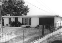
House on site affected by the construction of Interstate 26 (I-26). Possibly on Rivers Avenue. Surveyor notations on back of photo: "Dkt.: 10.486. Property owner: Williams Furniture Corp. Tract: 41. Station: 29+40 Lt. Date: May 30, 1961. In R/W - Bought." [See collection description for explanation of surveyor notations.]
House on site affected by the construction of Interstate 26 (I-26). Possibly on Rivers Avenue. Surveyor notations on back of photo: "Dkt.: 10.486. Property owner: Alberta Sanders, Est. Tract: 19. Station: 12+80 CL. Date: May 30, 1961. In R/W - Bought." [See collection description for explanation of surveyor notations.]
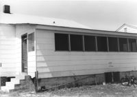
Building (rear view) on site affected by the construction of Interstate 26 (I-26). Building address number 1818. Possibly on Rivers Avenue. Surveyor notations on back of photo: "Dkt.: 10.486. Property owner: Dora Peagler. Tract: 20. Station: 13+50 Rt. Date: May 30, 1961. In R/W - Bought." [See collection description for explanation of surveyor notations.]
House on site affected by the construction of Interstate 26 (I-26). Building address number 1724. Possibly on Rivers Avenue. Surveyor notations on back of photo: "Dkt.: 10.486. Property owner: Frank H. Kelly. Tract: 5. Station: 8+35 Lt. Date: May 30, 1961. Proximity." [See collection description for explanation of surveyor notations.]
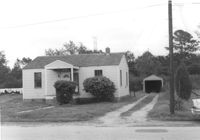
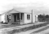
House on site affected by the construction of Interstate 26 (I-26). Building address number 181. Garage/shed at end of driveway. Surveyor notations on back of photo: "Dkt.: 10.480. Property owner: Winifred B. Gregory, et al. Tract: 127. Station: 5649+80 Rt. Date: May 2, 1961. In R/W - Bought." [See collection description for explanation of surveyor notations.]
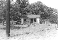
Sheds and old car, on site affected by the construction of Interstate 26 (I-26). [Building address number 131.] Surveyor notations on back of photo: "Dkt.: 10.480. Property owner: Minnie L. Geiger. Tract: 277. Station: 5726+80 Rt. (Line C). Date: May 31, 1961. In R/W - Bought." [See collection description for explanation of surveyor notations.]
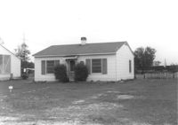
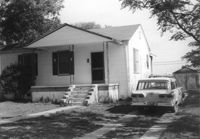
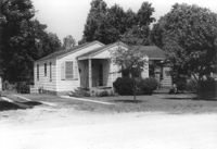
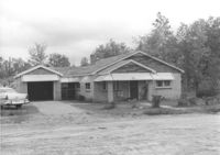
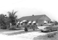
House on Dorchester Road, on site affected by the construction of Interstate 26 (I-26). Building address number 9. Surveyor notations on back of photo: "Dkt.: 10.480. Property owner: John H. Schulken, Est. Tract: 180. Station: 133+30 Rt. (Route 642) [Dorchester Road]. Date: May 31, 1961. In R/W - Bought." [See collection description for explanation of surveyor notations.]
House (corner view, rear) on site affected by the construction of Interstate 26 (I-26). Surveyor notations on back of photo: "Dkt.: 10.480. Property owner: J.E. Kitchins Sr. & Jr. Tract: 276. Station: 5726+90 Rt. (Line C). Date: May 31, 1961. In R/W - Bought." [See collection description for explanation of surveyor notations.]
House (corner view, rear) on site affected by the construction of Interstate 26 (I-26). Surveyor notations on back of photo: "Dkt.: 10.480. Property owner: William C. Minter. Tract: 279. Station: 5728+65 Lt. (Line C). Date: May 31, 1961. In R/W - Bought." [See collection description for explanation of surveyor notations.]
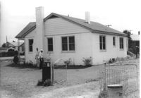
House (rear view) on site affected by the construction of Interstate 26 (I-26). Surveyor notations on back of photo: "Dkt.: 10.480. Property owner: Hugh A. Wingo, et al. Tract: 205. Station: 5691+40 Lt. Date: May 31, 1961. Proximity." [See collection description for explanation of surveyor notations.]
House (rear view) on site affected by the construction of Interstate 26 (I-26). Surveyor notations on back of photo: "Dkt.: 10.480. Property owner: Juanita Miller. Tract: 252. Station: 5705+15 Rt. Date: May 31, 1961. In R/W - Bought." [See collection description for explanation of surveyor notations.]
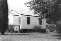
House (side view) on site affected by the construction of Interstate 26 (I-26). Surveyor notations on back of photo: "Dkt.: 10.480. Property owner: Mouzon Taylor. Tract: 253. Station: 5707+55 Rt. Date: May 31, 1961. In R/W - Bought." [See collection description for explanation of surveyor notations.]
House (rear view) on site affected by the construction of Interstate 26 (I-26). Surveyor notations on back of photo: "Dkt.: 10.480. Property owner: Charles E. Brewer. Tract: 235. Station: 5699+00 Lt. Date: May 31, 1961. Proximity to rear." [See collection description for explanation of surveyor notations.]
House on site affected by the construction of Interstate 26 (I-26). Surveyor notations on back of photo: "Dkt.: 10.480. Property owner: Hugh A. Wingo, et al. Tract: 205. Station: 5691+40 Lt. Date: May 31, 1961. Proximity." [See collection description for explanation of surveyor notations.]
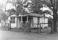
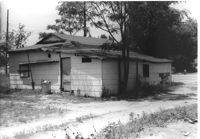
Dilapidated wooden structure (house?) on site affected by the construction of Interstate 26 (I-26). Surveyor notations on back of photo: "Dkt.: 10.480. Property owner: Jacob L. Nunnamaker. Tract: 234. Station: 5698+50 Lt. Date: May 31, 1961. Proximity." [See collection description for explanation of surveyor notations.]
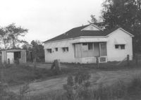
House on site affected by the construction of Interstate 26 (I-26). Outbuilding in background. Surveyor notations on back of photo: "Dkt.: 10.480. Property owner: Willie J. Gordon, et al. Tract: 71. Station: 5518+00 Rt. Date: May 2, 1961. In R/W - Bought." [See collection description for explanation of surveyor notations.]
House (corner view) on site affected by the construction of Interstate 26 (I-26). Surveyor notations on back of photo: "Dkt.: 10.480. Property owner: Jennie B. Henson, et al. Tract: 72. Station: 5517+70 Rt. Date: May 2, 1961. In R/W - Bought." [See collection description for explanation of surveyor notations.]
House in dilapidated condition on site affected by the construction of Interstate 26 (I-26). Surveyor notations on back of photo: "Dkt.: 10.480. Property owner: Watson Pugh, et al. Tract: 64. Station: 5519+30 Lt. Date: May 2, 1961. In R/W - Bought." [See collection description for explanation of surveyor notations.]
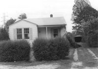
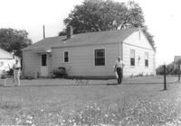
House on site affected by the construction of Interstate 26 (I-26). Surveyor notations on back of photo: "Dkt.: 10.480. Property owner: Virginia Green, et al. Tract: 68 & 69. Station: 5518+40 CL. Date: May 2, 1961. In R/W - Bought." [See collection description for explanation of surveyor notations.]
House on site affected by the construction of Interstate 26 (I-26). Surveyor notations on back of photo: "Dkt.: 10.480. Property owner: Collins Murray, et al. Tract: 65. Station: 5519+10 Lt. Date: May 2, 1961. In R/W - Bought." [See collection description for explanation of surveyor notations.]
House (corner view, rear) on site affected by the construction of Interstate 26 (I-26). Surveyor notations on back of photo: "Dkt.: 10.480. Property owner: Amos P. Hardy Sr., Est. Tract: 282. Station: 5732+20 Lt. (Line B). Date: May 30, 1961. Proximity." [See collection description for explanation of surveyor notations.]
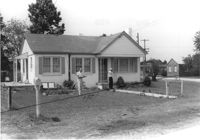
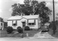
House on site affected by the construction of Interstate 26 (I-26). Building address number 195. Surveyor notations on back of photo: "Dkt.: 10.480. Property owner: Jack P. Brickman. Tract: 134. Station: 5654+05 Rt. Date: May 2, 1961. In R/W - Bought." [See collection description for explanation of surveyor notations.]
House on site affected by the construction of Interstate 26 (I-26). Building address number 223. Surveyor notations on back of photo: "Dkt.: 10.480. Property owner: Wilton T. Hall. Tract: 148. Station: 5662+60 Rt. Date: May 2, 1961. In R/W - Bought." [See collection description for explanation of surveyor notations.]
House (corner view, rear) on site affected by the construction of Interstate 26 (I-26). Surveyor notations on back of photo: "Dkt.: 10.480. Property owner: Norman Lubesky. Tract: 284. Station: 5733+50 Lt. (Line B). Date: May 30, 1961. In R/W - Bought." [See collection description for explanation of surveyor notations.]
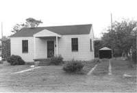
House on site affected by the construction of Interstate 26 (I-26). Garage/shed at end of driveway. Surveyor notations on back of photo: "Dkt.: 10.480. Property owner: R.R. Barwick. Tract: 137. Station: 5655+80 Rt. Date: May 2, 1961. In R/W - Bought." [See collection description for explanation of surveyor notations.]
House (corner view, rear) on site affected by the construction of Interstate 26 (I-26). Surveyor notations on back of photo: "Dkt.: 10.480. Property owner: Tujax, Inc. Tract: 283. Station: 5732+70 Lt. (Line B). Date: May 30, 1961. In R/W - Bought." [See collection description for explanation of surveyor notations.]
House on site affected by the construction of Interstate 26 (I-26). Surveyor notations on back of photo: "Dkt.: 10.480. Property owner: Mrs. Lovie Mae Smith. Tract: 287. Station: 5737+40 Lt. (Line B). Date: May 30, 1961. In R/W - Bought." [See collection description for explanation of surveyor notations.]