Search
Search Results
Date:
1977-1983
Description:
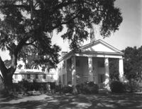
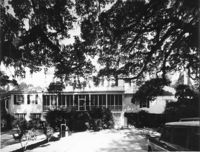
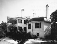
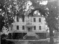
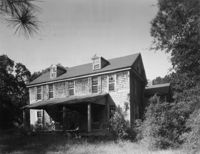
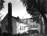
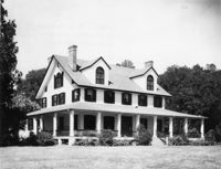
Georgetown County, Annandale Plantation, ca. 1791. Main House - View of SW (Front and Side) elevation. West wing is a 20th Century addition. 4" x 5" B/W photo.
Date:
1977-1983
Description:
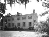
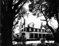
Georgetown County, Annandale Plantation, ca. 1791. Main House - View of NE (Side and Rear) elevation. 4" x 5" B/W photo.
Date:
1977-1983
Description:
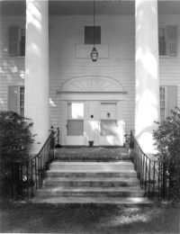
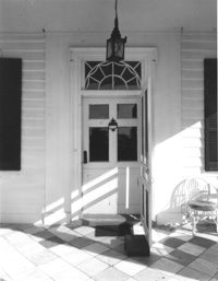
Georgetown County, Annandale Plantation, ca. 1791. Main House - Detail View of entry, South (Front) elevation. 4" x 5" B/W photo.
Date:
1977-1983
Description:
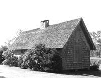
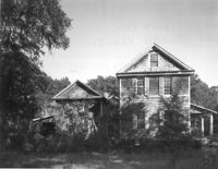
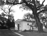
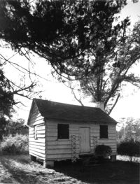
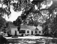
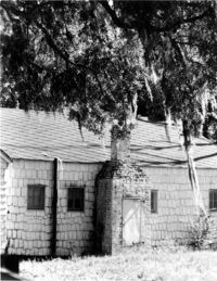
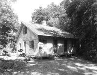
Georgetown County, Annandale Plantation, ca. 1791. Dependency - View of SE (Rear and Side) elevation. 4" x 5" B/W photo.
Date:
1977-1983
Description:
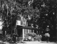
Georgetown County, Arcadia Plantation, ca. 1794. View of East (Rear) elevation. 4" x 5" B/W photo.
Date:
1977-1983
Description:
Georgetown County, Arcadia Plantation, ca. 1794. View of SE (Side and Rear) elevation. 4" x 5" B/W photo.
Date:
1977-1983
Description:
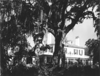
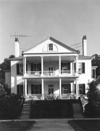
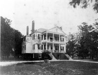
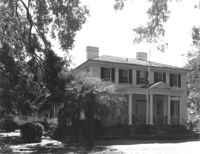
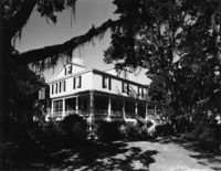
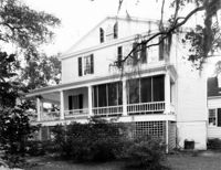
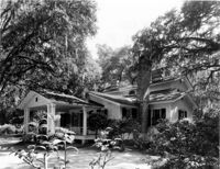
Georgetown County, Arcadia Plantation, ca. 1794. View of West (Front) elevation. 4" x 5" B/W photo.
Date:
1977-1983
Description:
Georgetown County, Arcadia Plantation, ca. 1794. View of NW (Front and Side) elevation. 4" x 5" B/W photo.
Date:
1977-1983
Description:
Georgetown County, Arcadia Plantation, ca. 1794. View of SW (Front and Side) elevation 4" x 5" B/W photo.
Date:
1977-1983
Description:
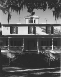
Georgetown County, Arcadia Plantation, ca. 1794. Detail View of entry, West (Front) elevation. 4" x 5" B/W photo.
Date:
1977-1983
Description:
Georgetown County, Arcadia Plantation, ca. 1794. View of West (Front) elevation. 4" x 5" B/W photo.
Date:
1977-1983
Description:
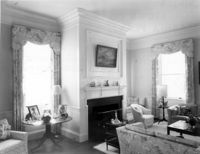
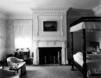
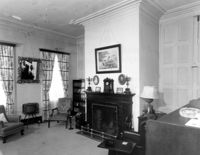
Georgetown County, Arcadia Plantation, ca. 1794. Interior View - 1st Floor, SW room. 4" x 5" B/W photo.
Date:
1977-1983
Description:
Georgetown County, Arcadia Plantation, ca. 1794. Interior View - 2nd Floor, NW room 4" x 5" B/W photo.
Date:
1977-1983
Description:
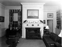
Georgetown County, Arcadia Plantation, ca. 1794. Interior View - 1st Floor, NW room. 4" x 5" B/W photo.
Date:
1977-1983
Description:
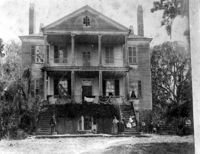
Georgetown County, Arcadia Plantation, ca. 1794. Copy of 1893 photo. View of West (Front) elevation. 4" x 5" B/W photo.
Date:
1977-1983
Description:
Georgetown County, Arcadia Plantation, ca. 1794. Copy of 1900 photo. View of NW (Front and Side) elevation. 4" x 5" B/W photo.
Date:
1977-1983
Description:
Georgetown County, Arcadia Plantation, ca. 1794. Copy of 1900 photo. View of East (Rear) elevation. 4" x 5" B/W photo.
Date:
1977-1983
Description:
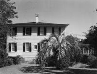
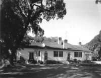
Georgetown County, Beneventum Plantation, ca. 1746. View of North (Front) elevation. 4" x 5" B/W photo.
Date:
1977-1983
Description:
Georgetown County, Beneventum Plantation, ca. 1746. View of West (Side) elevation. 4" x 5" B/W photo.
Date:
1977-1983
Description:
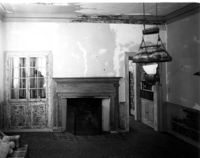
Georgetown County, Beneventum Plantation, ca. 1746. Interior View - 1st Floor. SW Room, Detail of mantle. 4" x 5" B/W photo.
Date:
1977-1983
Description:
Georgetown County, Beneventum Plantation, ca. 1746. Interior View - 1st Floor. NE Room, South elevation. 4" x 5" B/W photo.
Date:
1977-1983
Description:
Georgetown County, Cat Island Plantation. View of NE (Front and Side) elevation. 4" x 5" B/W photo.
Date:
1977-1983
Description:
Georgetown County, Cat Island Plantation. View of South (Side) elevation. 4" x 5" B/W photo.
Date:
1977-1983
Description:
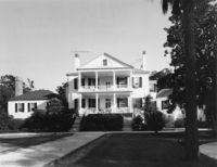
Georgetown County, Chicora Wood Plantation, ca. 1819. Main House - View of SW (Side and Front) elevation. 4" x 5" B/W photo.
Date:
1977-1983
Description:
Georgetown County, Chicora Wood Plantation, ca. 1819. Main House - View of South (Front) elevation. 4" x 5" B/W photo.
Date:
1977-1983
Description:
Georgetown County, Chicora Wood Plantation, ca. 1819. Main House - View of NE (Side and Rear) elevation. 4" x 5" B/W photo.
Date:
1977-1983
Description:
Georgetown County, Chicora Wood Plantation, ca. 1819. Main House - View of East (Side) elevation. 4" x 5" B/W photo.
Date:
1977-1983
Description:
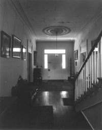
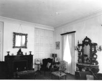
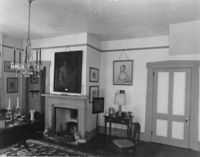
Georgetown County, Chicora Wood Plantation, ca. 1819. Main House - Interior View. 1st Floor - Hall, North elevation. 4" x 5" B/W photo.
Date:
1977-1983
Description:
Georgetown County, Chicora Wood Plantation, ca. 1819. Main House - Interior View. 1st Floor - NE Room, South elevation. 4" x 5" B/W photo.
Date:
1977-1983
Description:
Georgetown County, Chicora Wood Plantation, ca. 1819. Main House - Interior view. 1st Floor - SE Room, North elevation. 4" x 5" B/W photo.
Date:
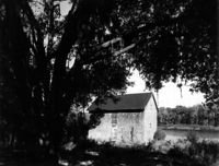
1977-1983
Description:
Georgetown County, Chicora Wood Plantation, ca. 1819. Kitchen House - View of SE (Front and Side) elevation. 4" x 5" B/W photo.
Date:
1977-1983
Description:
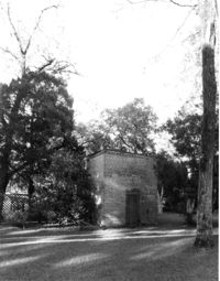
Georgetown County, Chicora Wood Plantation, ca. 1819. Smokehouse - View of SW (Front and Side) elevation. 4" x 5" B/W photo.
Date:
1977-1983
Description:
Georgetown County, Chicora Wood Plantation, ca. 1819. Laundry Building - View of SW (Side and Front) elevation. 4" x 5" B/W photo.
Date:
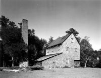
1977-1983
Description:
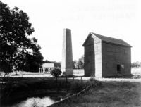
Georgetown County, Chicora Wood Plantation, ca. 1819. Rice Threshing Mill with Chimney Stack - View of SW (front and Side) elevation. 4" x 5" B/W photo.
Date:
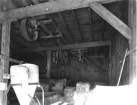
1977-1983
Description:
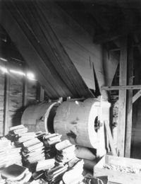
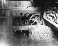
Georgetown County, Chicora Wood Plantation, ca. 1819. Rice Threshing Mill - Interior View of threshers, North elevation. 4" x 5" B/W photo.
Date:
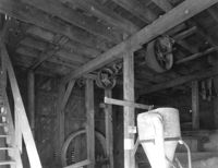
1977-1983
Description:
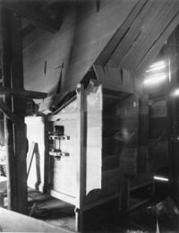
Georgetown County, Chicora Wood Plantation, ca. 1819. Rice Threshing Mill - Interior View showing pulleys for belt connections to threshers and boilers. 4" x 5" B/W photo.
Date:
1977-1983
Description:
Georgetown County, Chicora Wood Plantation, ca. 1819. Rice Shipping House - View of SW (Rear and Side) elevation. 4" x 5" B/W photo.
Date:
1977-1983
Description:
Georgetown County, Chicora Wood Plantation, ca. 1819. Cabin - View of Front elevation (possibly a slave cabin). 4" x 5" B/W photo.
Date:
1977-1983
Description:
Georgetown County, Dirleton Plantation, ca. 1825. View of East (Front) elevation. 4" x 5" B/W photo.
Date:
1977-1983
Description:
Georgetown County, Dirleton Plantation, ca. 1825. View of West (Rear and Side) elevation. 4" x 5" B/W photo.
Date:
1977-1983
Description:
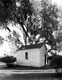
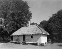
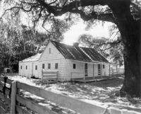
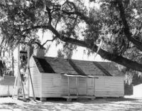
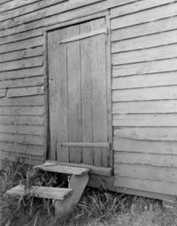
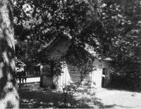
Georgetown County, Hopsewee Plantation, ca. 1740. Slave Quarters, North Building. 4" x 5" B/W photo.
Date:
1977-1983
Description:
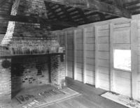
Georgetown County, Hopsewee Plantation, ca. 1740. Slave Quarters, North Building - Interior View. East Room (West elevation) showing fireplace. 4" x 5" B/W photo.
Date:
1977-1983
Description:
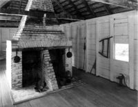
Georgetown County, Hopsewee Plantation, ca. 1740. Slave Quarters, South Building - Interior View. East Room (West elevation) showing double fireplace. 4" x 5" B/W photo.
Date:
1977-1983
Description:
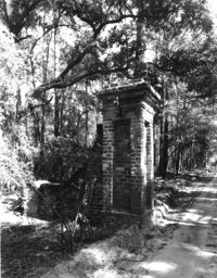
Georgetown County, Mansfield Plantation, ca. 1718. View of Brick gate post. 4" x 5" B/W photo.
Date:
1977-1983
Description:
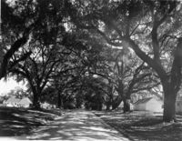
Georgetown County, Mansfield Plantation, ca. 1718. View of Oak Allee. 4" x 5" B/W photo.
Date:
1977-1983
Description:
Georgetown County, Mansfield Plantation, ca. 1780. Main House - View of West (Front) elevation. 4" x 5" B/W photo.
Date:
1977-1983
Description:
Georgetown County, Mansfield Plantation, ca. 1780. Main House - View of East (Rear) elevation. 4" x 5" B/W photo.
Date:
1977-1983
Description:
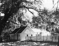
Georgetown County, Mansfield Plantation, ca. 1780. Slave Quarters - View of Side and Front elevation. 4" x 5" B/W photo.
Date:
1977-1983
Description:
Georgetown County, Mansfield Plantation, ca. 1780. Slave Quarters - View of Side and Front elevation. 4" x 5" B/W photo.
Date:
1977-1983
Description:
Georgetown County, Mansfield Plantation, ca. 1780. Slave Quarters - Detail View of chimney. 4" x 5" B/W photo.
Date:
1977-1983
Description:
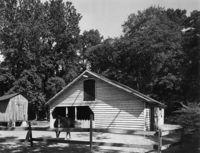
Georgetown County, Mansfield Plantation, ca. 1780. Schoolhouse - View of North (Front) elevation. 4" x 5" B/W photo.
Date:
1977-1983
Description:
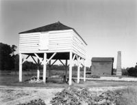
Georgetown County, Mansfield Plantation, ca. 1780. Winnowing House - View of Front elevation (Rice Threshing Mill in background). 4" x 5" B/W photo.
Date:
1977-1983
Description:
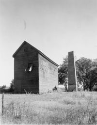
Georgetown County, Mansfield Plantation, ca. 1780. Rice Threshing Mill and Chimney Stack - View of Side and Rear elevation. 4" x 5" B/W photo.
Date:
1977-1983
Description:
Georgetown County, Mansfield Plantation, ca. 1780. Rice Threshing Mill and Chimney Stack - View of Front and Side elevation. 4" x 5" B/W photo.
Date:
1977-1983
Description:
Georgetown County, Mansfield Plantation, ca. 1780. Rice Threshing Mill - Detail View of entrance. 4" x 5" B/W photo.
Date:
1977-1983
Description:
Georgetown County, Mansfield Plantation, ca. 1780. Rice Threshing Mill - Interior View. Threshers, SW elevation. 4" x 5" B/W photo.
Date:
1977-1983
Description:
Georgetown County, Mansfield Plantation, ca. 1780. Rice Threshing Mill - Interior View. Threshers, SE elevation. 4" x 5" B/W photo.
Date:
1977-1983
Description:
Georgetown County, Mansfield Plantation, ca. 1780. Rice Threshing Mill - Interior View. Pulleys for belt connection from boiler to thresher. 4" x 5" B/W photo.
Date:
1977-1983
Description:
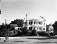
Georgetown County, Wicklow Hall Plantation, ca. 1825. Main House - View of North (Front) elevation. 4" x 5" B/W photo.
Date:
1977-1983
Description:
Georgetown County, Wicklow Hall Plantation, ca. 1825. Main House - View of South (Rear) elevation. 4" x 5" B/W photo.
Date:
1977-1983
Description:
Georgetown County, Wicklow Hall Plantation, ca. 1825. Main House - Interior View. 1st Floor - SW Room, North elevation. 4" x 5" B/W photo.
Date:
1977-1983
Description:
Georgetown County, Wicklow Hall Plantation, ca. 1825. Kitchen Building - View of Side and Front elevation. 4" x 5" B/W photo.
Date:
1977-1983
Description:
Georgetown County, Wicklow Hall Plantation, ca. 1825. Slave Quarters - View of Side and Front elevation. 4" x 5" B/W photo.
Date:
1977-1983
Description:
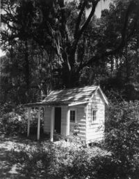
Georgetown County, Wicklow Hall Plantation, ca. 1825. Playhouse - View of Front and Side elevation. 4" x 5" B/W photo.
Date:
1977-1983
Description:
Georgetown County, Wicklow Hall Plantation, ca. 1825. Carriage House - View of Front and Side elevation. 4" x 5" B/W photo.
Date:
1977-1983
Description:
Georgetown County, Wicklow Hall Plantation, ca. 1825. Barn - View of Front and Side elevation. 4" x 5" B/W photo.
Date:
1977-1983
Description:
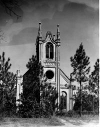
Georgetown County, Prince Frederick's Episcopal Church (Ruins), ca. 1859. View of West (Front) elevation. 4" x 5" B/W photo.
Date:
1977-1983
Description:
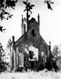
Georgetown County, Prince Frederick's Episcopal Church (Ruins), ca. 1859. View of South (Side) elevation. 4" x 5" B/W photo.
Date:
1977-1983
Description:
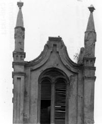
Georgetown County, Prince Frederick's Episcopal Church (Ruins), ca. 1859. View of East (Rear) elevation. 4" x 5" B/W photo.
Date:
1977-1983
Description:
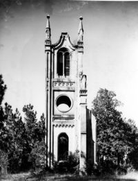
Georgetown County, Prince Frederick's Episcopal Church (Ruins), ca. 1859. Detail View of Bell Tower, South (Side) elevation. 4" x 5" B/W photo.