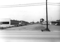
View of buildings in previous photos (Health Club, pizza restaurant, Nilson Storage Warehouse), on site affected by the construction of Interstate 26 (I-26). Surveyor notations on back of photo: "Dkt.: 10.480. Property owner: G.S. Carter, Sr. Tract: 162. Station: 5675+00 - 5679+75 Rt. & Lt. Date: May 30, 1961. View from across Route 642 [Dorchester Road]." [See collection description for explanation of surveyor notations.]
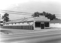
Terrace Market on site affected by the construction of Interstate 26 (I-26). Building is closed. Sunbeam Bread sign on side of building. Front facade has stepped parapet. Surveyor notations on back of photo: "Dkt.: 10.480. Property owner: John C. Gelegotes, et al. Tract: 163. Station: 5681+00 Rt. Date: May 30, 1961. In R/W - Bought." [See collection description for explanation of surveyor notations.]
Terrace Market on site affected by the construction of Interstate 26 (I-26). Building is closed. Sunbeam Bread sign on side of building. Front facade has stepped parapet. Surveyor notations on back of photo: "Dkt.: 10.480. Property owner: John C. Gelegotes, et al. Tract: 163. Station: 5681+00 Rt. Date: May 30, 1961. In R/W - Bought." [See collection description for explanation of surveyor notations.]
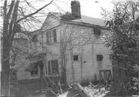
House (rear view) on site affected by the construction of the Crosstown. Address: 176 Nassau Street. Surveyor notations on back of photo: "Dkt.: 10.518. Property owner: Carole B. Priester. Tract: 32. Station: 42+05 Lt. N.B. lane Route 17. Date: Mar. 6, 1963. In R/W - Bought. [See collection description for explanation of surveyor notations.]
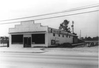
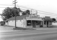
The Spudnut Shop [3646 Dorchester Road], on site affected by the construction of Interstate 26 (I-26). Front facade has stepped parapet. Neighboring building, Pick & Pay Grocery, also in photo. Surveyor notations on back of photo: "Dkt.: 10.480. Property owner: John C. Gelegotes, et al. Tract: 164. Station: 5681+50 on CL. Date: May 30, 1961. In R/W - Bought." [See collection description for explanation of surveyor notations.]
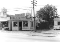
Pick & Pay Grocery, on site affected by the construction of Interstate 26 (I-26). Front facade has stepped parapet. Partial view of neighboring building, The Spudnut Shop, also in photo. Surveyor notations on back of photo: "Dkt.: 10.480. Property owner: Arlene Phillips, Est. Tract: 165. Station: 5681+60 Lt. Date: May 30, 1961. In R/W - Bought." [See collection description for explanation of surveyor notations.]
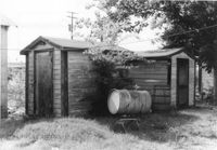
Sheds on site affected by the construction of Interstate 26 (I-26). Surveyor notations on back of photo: "Dkt.: 10.480. Property owner: Arlene Phillips, Est. Tract: 165. Station: 5681+10 Lt. Date: May 30, 1961. In R/W - Bought." [See collection description for explanation of surveyor notations.]
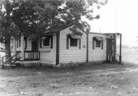
House on site affected by the construction of Interstate 26 (I-26). Surveyor notations on back of photo: "Dkt.: 10.480. Property owner: Arlene Phillips, Est. Tract: 165. Station: 5680+75 Lt. Date: May 30, 1961. In R/W - Bought." [See collection description for explanation of surveyor notations.]
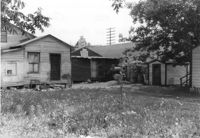
Rear view of dwellings and other structures on site affected by the construction of Interstate 26 (I-26). Sign for The Spudnut Shop in mid-background. Surveyor notations on back of photo: "Dkt.: 10.480. Property owner: Arlene Phillips, Est. Tract: 165. Station: 5680+75 Lt. Date: May 30, 1961. In R/W - Bought." [See collection description for explanation of surveyor notations.]
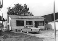
Pick & Pay Bicycle Repair Shop on site affected by the construction of Interstate 26 (I-26). Surveyor notations on back of photo: "Dkt.: 10.480. Property owner: G.S. Carter, Sr. Tract: 166. Station: 5681+50 Lt. Date: May 30, 1961. In R/W - Bought." [See collection description for explanation of surveyor notations.]