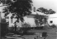
House (corner view, rear) on site affected by the construction of Interstate 26 (I-26). Surveyor notations on back of photo: "Dkt.: 10.480. Property owner: Jessie L. & Doris S. Bercaw. Tract: 272. Station: 5725+00 Lt. (Line C). Date: May 31, 1961. In R/W - Bought." [See collection description for explanation of surveyor notations.]
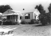
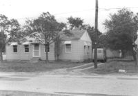
House on site affected by the construction of Interstate 26 (I-26). Building address number 145. Surveyor notations on back of photo: "Dkt.: 10.480. Property owner: Jerome M. Williams. Tract: 270. Station: 5724+10 Lt. (Line C). Date: May 31, 1961. Proximity." [See collection description for explanation of surveyor notations.]
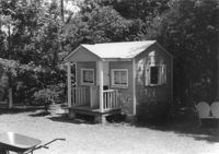
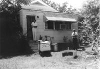
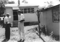
Child's playhouse or small guest house, on site affected by the construction of Interstate 26 (I-26). Surveyor notations on back of photo: "Dkt.: 10.480. Property owner: Juanita Miller. Tract: 252. Station: 5707+65 Rt. Date: May 31, 1961. In R/W - Bought." [See collection description for explanation of surveyor notations.]
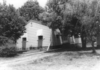
House on site affected by the construction of Interstate 26 (I-26). Partially obscured by trees. Surveyor notations on back of photo: "Dkt.: 10.480. Property owner: C.G. Hudson. Tract: 250. Station: 5706+30 Lt. Date: May 31, 1961. In R/W - Bought." [See collection description for explanation of surveyor notations.]
House (rear view) on site affected by the construction of Interstate 26 (I-26). Surveyor notations on back of photo: "Dkt.: 10.480. Property owner: Mrs. Sarah Elise P. Ford Thompson. Tract: 260. Station: 5712+20 Lt. Date: May 31, 1961. In R/W - Bought." [See collection description for explanation of surveyor notations.]
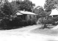
House (rear view) and yard, on site affected by the construction of Interstate 26 (I-26). Surveyor notations on back of photo: "Dkt.: 10.480. Property owner: Matthew J. & Winifred C. Polutto. Tract: 266. Station: 5715+00 Lt. Date: May 31, 1961. Proximity." [See collection description for explanation of surveyor notations.]
House (rear view) on site affected by the construction of Interstate 26 (I-26). Surveyor notations on back of photo: "Dkt.: 10.480. Property owner: John J. & Yolanda W. Houton. Tract: 265. Station: 5714+55 Lt. Date: May 31, 1961. Proximity." [See collection description for explanation of surveyor notations.]
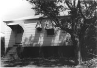
House (corner view, rear) on site affected by the construction of Interstate 26 (I-26). Surveyor notations on back of photo: "Dkt.: 10.480. Property owner: D.T. Browning. Tract: 263. Station: 5713+85 Lt. Date: May 31, 1961. In R/W - Bought." [See collection description for explanation of surveyor notations.]
House on site affected by the construction of Interstate 26 (I-26). Dirt road and driveway in foreground. Surveyor notations on back of photo: "Dkt.: 10.480. Property owner: Claude Henslee. Tract: 204. Station: 5690+95 Lt. Date: May 31, 1961. Proximity to rear." [See collection description for explanation of surveyor notations.]
House on site affected by the construction of Interstate 26 (I-26). Obscured by shadows and tree. Surveyor notations on back of photo: "Dkt.: 10.480. Property owner: James R. & Elanor P. Cooper. Tract: 246. Station: 5706+00 Rt. Date: May 31, 1961. In R/W - Bought." [See collection description for explanation of surveyor notations.]
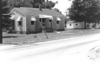
House on site affected by the construction of Interstate 26 (I-26). Building address number 80. Surveyor notations on back of photo: "Dkt.: 10.480. Property owner: William F. Carter. Tract: 243. Station: 5704+85 Rt. Date: May 31, 1961. In R/W - Bought." [See collection description for explanation of surveyor notations.]
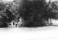
House (rear view) on site affected by the construction of Interstate 26 (I-26). Surveyor notations on back of photo: "Dkt.: 10.480. Property owner: Crider O. Murray. Tract: 202. Station: 5689+90 Lt. Date: May 31, 1961. In R/W - Bought." [See collection description for explanation of surveyor notations.]
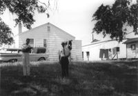
Garage/shed on site affected by the construction of Interstate 26 (I-26). Surveyor notations on back of photo: "Dkt.: 10.480. Property owner: Florence K. Byfield. Tract: 248. Station: 5705+40 Lt. Date: May 31, 1961. In R/W - Bought." [See collection description for explanation of surveyor notations.]
House on site affected by the construction of Interstate 26 (I-26). Partially obscured by trees. Surveyor notations on back of photo: "Dkt.: 10.480. Property owner: C.H. & Elise V. Meidburg. Tract: 249. Station: 5705+80 Lt. Date: May 31, 1961. In R/W - Bought." [See collection description for explanation of surveyor notations.]
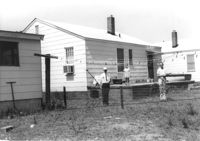
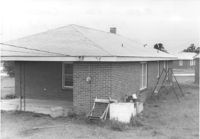
House (corner view, rear) on site affected by the construction of Interstate 26 (I-26). Surveyor notations on back of photo: "Dkt.: 10.480. Property owner: James H. Black. Tract: 245. Station: 5705+60 Rt. Date: May 31, 1961. In R/W - Bought." [See collection description for explanation of surveyor notations.]
House (rear view) on site affected by the construction of Interstate 26 (I-26). Surveyor notations on back of photo: "Dkt.: 10.480. Property owner: Claude Henslee. Tract: 204. Station: 5690+95 Lt. Date: May 31, 1961. Proximity." [See collection description for explanation of surveyor notations.]
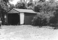
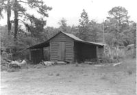
Shed/garage on site affected by the construction of Interstate 26 (I-26). Surveyor notations on back of photo: "Dkt.: 10.480. Property owner: Preston H. Mundy. Tract: 104. Station: 41+50 Line A). Date: May 2, 1961. In R/W - Bought." [See collection description for explanation of surveyor notations.]
House on site affected by the construction of Interstate 26 (I-26). Building address number 177. Garage/shed at end of driveway. Surveyor notations on back of photo: "Dkt.: 10.480. Property owner: P.F. Hartline. Tract: 125. Station: 5648+60 Rt. Date: May 2, 1961. In R/W - Bought." [See collection description for explanation of surveyor notations.]
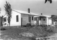
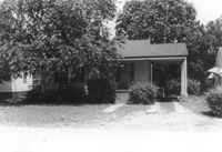
House (rear view) on site affected by the construction of Interstate 26 (I-26). Surveyor notations on back of photo: "Dkt.: 10.480. Property owner: Burl T. Wortham, et al. Tract: 161. Station: 5672+00 Rt. Date: May 1, 1961. In R/W - Bought." [See collection description for explanation of surveyor notations.]
House (rear view) on site affected by the construction of Interstate 26 (I-26). Surveyor notations on back of photo: "Dkt.: 10.480. Property owner: O.H. Julian. Tract: 203. Station: 5690+35 Lt. Date: May 31, 1961. Proximity." [See collection description for explanation of surveyor notations.]