"Appeal to South Carolina Supreme Court: The City of Charleston v. Esau Jenkins. Includes published appeal to South Carolina Supreme Court requesting dismissal of Jenkins' 1962 conviction for selling alcohol after hours."
Newspaper printed for the civilian employees of the Charleston Naval Shipyard starting on January 19th 1962. This volume covers from January 19th 1962 to December 21st 1962.
House (corner view, rear) on site affected by the construction of Interstate 26 (I-26). Surveyor notations on back of photo: "Dkt.: 10.490. Property owner: Herbert Williams, et al. Tract: 108. Station: 5828+90 Rt. Date: March 22, 1962. In R/W - Bought." [See collection description for explanation of surveyor notations.]
House (rear view) on site affected by the construction of Interstate 26 (I-26). Surveyor notations on back of photo: "Dkt.: 10.490. Property owner: Daisey Bough, et al. Tract: 106. Station: 5828+90 Lt. Tract: 105. Station: 5828+90 Lt. Date: March 22, 1962. In R/W - Bought." [See collection description for explanation of surveyor notations.]
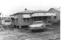
House (corner view, rear) on site affected by the construction of Interstate 26 (I-26). Surveyor notations on back of photo: "Dkt.: 10.490. Property owner: Christine Morris, et al. Tract: 109. Station: 5828+75 Rt. Date: March 22, 1962. In R/W - Bought." [See collection description for explanation of surveyor notations.]
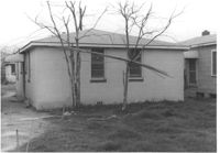
House (side view) and lot, on site affected by the construction of Interstate 26 (I-26). Surveyor notations on back of photo: "Dkt.: 10.490. Property owner: Jacob Bennekin. Tract: 138-A. Station: 5858+90 Lt. Date: August 29, 1962. In R/W - Bought." [See collection description for explanation of surveyor notations.]
House on site affected by the construction of Interstate 26 (I-26). Surveyor notations on back of photo: "Dkt.: 10.490. Property owner: Daisey Bough, et al. Tract: 106. Station: 5828+90 Lt. Tract: 105. Station: 5828+90 Lt. Date: March 22, 1962. In R/W - Bought." [See collection description for explanation of surveyor notations.]
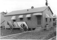
House (rear view) on site affected by the construction of Interstate 26 (I-26). Surveyor notations on back of photo: "Dkt.: 10.490. Property owner: Louis Green. Tract: 138-B. Station: 5858+70 Lt. Date: August 29, 1962. In R/W - Bought." [See collection description for explanation of surveyor notations.]
House on site affected by the construction of Interstate 26 (I-26). Surveyor notations on back of photo: "Dkt.: 10.490. Property owner: Herbert Williams, et al. Tract: 108. Station: 5828+90 Rt. Date: March 22, 1962. In R/W - Bought." [See collection description for explanation of surveyor notations.]
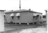
House on site affected by the construction of Interstate 26 (I-26). Surveyor notations on back of photo: "Dkt.: 10.490. Property owner: Jacob Bennekin. Tract: 138-A. Station: 5858+90 Lt. Date: August 29, 1962. In R/W - Bought." [See collection description for explanation of surveyor notations.]
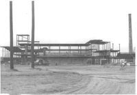
Virginia-Carolina Chemical Corp. structures on site affected by the construction of Interstate 26 (I-26). [VC Chemical Corp. was located on King Street Extn.] Surveyor notations on back of photo: "Dkt.: 10.490. Property owner: V.C. Chemical Co. Tract: 1. Station: 5800+00 Rt. Date: September 11, 1962. To be cut off at R/W." [See collection description for explanation of surveyor notations.]
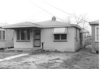
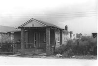
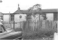
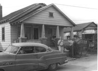
House on site affected by the construction of Interstate 26 (I-26). Building address number 2135. Surveyor notations on back of photo: "Dkt.: 10.490. Property owner: Sheppard Siders. Tract: 138-E. Station: 5858+00 Lt. Date: May 15, 1962. Owner to cut porch to clear R/W." [See collection description for explanation of surveyor notations.]
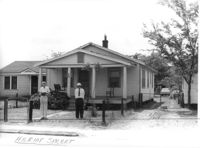
House at 2161 Heriot Street, on site affected by the construction of Interstate 26 (I-26). Address: 2159 Heriot Street. Surveyor notations on back of photo: "Dkt.: 10.490. Property owner: Henry Yaschik. Tract: 147-B. Station: 175' Lt. Sta. 5879+35. Date: May 15, 1962. Proximity." [See collection description for explanation of surveyor notations.]
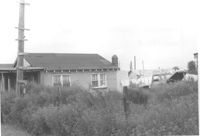
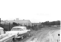
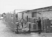
Dirt road and Charleston Oil Co. structures, on site affected by the construction of Interstate 26 (I-26). Surveyor notations on back of photo: "Dkt.: 10.490. Property owner: Charleston Oil Co. Tract: 140 and 140-A. Station: 5861+51 Rt. and Lt. (crosses CL). Date: August 29, 1962. In R/W - Bought." [See collection description for explanation of surveyor notations.]
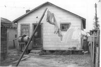
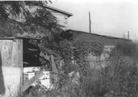
House (rear view) on site affected by the construction of Interstate 26 (I-26). Surveyor notations on back of photo: "Dkt.: 10.490. Property owner: Henry Ford, et al. Tract: 138-C. Station: 5858+40 Lt. Date: August 29, 1962. In R/W - Bought." [See collection description for explanation of surveyor notations.]
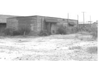
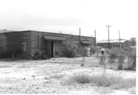
Structure on site affected by the construction of Interstate 26 (I-26). Surveyor notations on back of photo: "Dkt.: 10.490. Property owner: Ashley River Realty Co. Tract: 142. Station: 5876+60 Lt. Date: August 29, 1962. In R/W - Bought." [See collection description for explanation of surveyor notations.]
Structure on site affected by the construction of Interstate 26 (I-26). Surveyor notations on back of photo: "Dkt.: 10.490. Property owner: Ashley River Realty Co. Tract: 142. Station: 5876+60 Lt. Date: August 29, 1962. In R/W - Bought." [See collection description for explanation of surveyor notations.]
Renken Boat Co, on site affected by the widening of Route 171 (Folly Road). Surveyor notations on back of photo: "Dkt.: 10.494. Property owner: Renken Finance Co. Tract: 19. Station: 157+00 Lt. Date: Mar. 21, 1962. Proximity. [See collection description for explanation of surveyor notations.]
House (rear view) on site affected by the construction of Interstate 26 (I-26). [Building address number 2003(?).]Surveyor notations on back of photo: "Dkt.: 10.490. Property owner: L. Bradley. Tract: 39. Station: 5797+70 on CL Line 'G'. Date: September 11, 1962. In R/W - Bought." [See collection description for explanation of surveyor notations.]
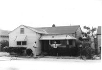
House on site affected by the construction of Interstate 26 (I-26). Building address number 2009(?). Surveyor notations on back of photo: "Dkt.: 10.490. Property owner: John Simmons, Est. Tract: 42. Station: 5798+60 on CL Line 'G'. Date: September 12, 1962. In R/W - Bought." [See collection description for explanation of surveyor notations.]