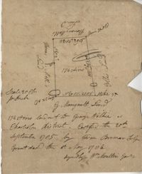
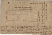
Plan of 500 acres of land south of the Mile Swamp and near the May River. Names associated with this plat are J. Pears and Bellamy Crawford. Notable geographic locations are The Thickets, May River, The Mile Swamp and St. Luke's Parish.
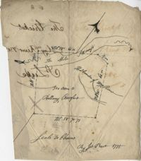
Plat of land belonging to Bellamy Crawford possibly called the Thickets. Names associated with this plat are Bellamy Crawford. Notable geographic locations are May River, The Mile Swamp and St. Luke's Parish.
Plan of a tract of 1000 acres of land in Wall Eye Swamp in Craven County [now in parts of Berkeley, Charleston, Georgetown, and Williamsburg counties]. Names associated with this plat are Samuel Cooper, James Sinkler, Peter Sinkler, Isham Moore, John Bremar, and William Bull.
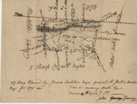
Copy of a plat of 250 acres laid out to Abraham Michau on the north side of Santee River and “now belonging to John Pedro." Names associated with this plat are Abraham Michau, John Pedro, George Hunter and James Glen. Notable geographic locations include the Santee River, Prince Frederick Parish and Georgetown District.
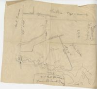
Plat of 53 acres off of Dorchester Road which is divided into lots. Very little details or information. Names associated with this plat are Fitch and Beckman. Notable geographic locations include Dorchester Road.
Plat of 500 acres in Craven County on the Pee Dee River annexed to the original 40,000 acres orginally granted to Landgrave Robert Daniel. Names associated with this plat are Robert Daniel, Robert Gibbs, the Lords Proprietors, Thomas Broughton and Waring. Notable geographic locations include the Pee Dee River, Craven County [now in parts of Berkeley, Charleston, Georgetown, and Williamsburg counties], Sawhee, Beedee, and Georgetown District.
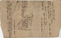
1432 acres of land given to Villeconteux; shows mill creek and Raccoon Pond, one area is colored in red labeled "Gardenes Old Field." Names associated with this plat are Barry Villeconteux, Rich Selby, N. Windham, Rhames, Ben Villeponteaux, Lowe Leviman, W.W. Villeponteaux, J.C. Brinson, Addison, Gaillard, Homes, and Thomas Ashley. Notable geographic locations include St. John's Parish, Raccoon Pond, Mill Creek, School House Branch, Blind Doe Run, and Edge Poing.
Copy of a plat laid out at Goose Creek now belonging to Benjamin Mazyck. 200 acres of land commonly called Busharia. Butting and bounding on the north and west on Col. James Moore land and the south on Captain Schrenckingh and on the east on Madam Davis' land. Names associated with this plat are Benjamin Mazyck, Davis, Lawson, Thomas Smith, Benjamin Schrenckingh, James Moore, and David Daw. Notable geographic locations include Busharia, Booshee, and Goose Creek.
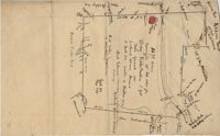
Plat of 89 acres in the Beaufort District. Plat shows the location of several ponds. Little other detail is included. Names associated with this plat are N.H. Johnson, R.J. Marker, Mary Kittles, John H. Raddell [?], and Brown. Notable geographic locations include the Savannah River, Beaufort District and Dry Gull Branch.
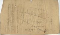
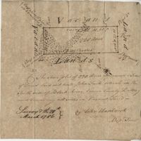
Plat of 220 acres on the Black River belonging to John Luck. Details include the areas of the river and marsh, and the location of trees on the property lines. Names associated with this plat are John Luch and John Hardwick. Notable geographic locations include Black River and Craven County Craven County [now in parts of Berkeley, Charleston, Georgetown, and Williamsburg counties].
Limit your search
John McCrady Plats and Deeds Collection✖[remove]247