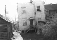
House (rear view) on site affected by the construction of the Crosstown. Address: 98 Hanover Street. Surveyor notations on back of photo: "Dkt.: 10.518. Property owner: Rosalie Pezant, et al. Tract: 48. Station: 45+20 CL N.B. lane Route 17. Date: Mar. 6, 1963. In R/W - Bought." [See collection description for explanation of surveyor notations.]
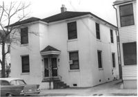
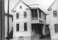
House (duplex) on site affected by the construction of Interstate 26 (I-26). Address: 103A-103B Sheppard Street. (1951 Sanborn map indicates the address is 99 Sheppard Street.) Surveyor notations on back of photo: "Dkt.: 10.517. Property owner: Hyman Karesh, Est. Tract: 97. Station: 22+35 CL Northbound Lane Route 17. Date: March 5, 1963. In R/W - Bought." [See collection description for explanation of surveyor notations.]
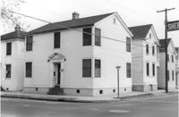
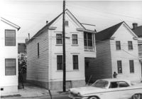
House on Sheppard Street at the corner of Coming Street, on site affected by the construction of Interstate 26 (I-26). Address: 105 Sheppard Street. View of Street corner. Surveyor notations on back of photo: "Dkt.: 10.517. Property owner: Hyman Karesh, Est. Tract: 97. Station: 22+00 Northbound Lane Route 17. Date: March 5, 1963. In R/W - Bought." [See collection description for explanation of surveyor notations.]
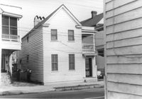
House on Sheppard Street at the corner of Coming Street (Coming Street elevation), on site affected by the construction of Interstate 26 (I-26). Address: 105 Sheppard Street. View of Street corner. Surveyor notations on back of photo: "Dkt.: 10.517. Property owner: Hyman Karesh, Est. Tract: 97. Station: 22+00 Northbound Lane Route 17. Date: March 5, 1963. In R/W - Bought." [See collection description for explanation of surveyor notations.]
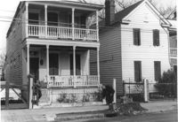
House near the corner of Sheppard Street, on site affected by the construction of Interstate 26 (I-26). Address: 280 Coming Street. Surveyor notations on back of photo: "Dkt.: 10.517. Property owner: Jessica P. Brown. Tract: 98. Station: 22+00 Rt. Northbound Lane Route 17. Date: March 5, 1963. In R/W - Bought." [See collection description for explanation of surveyor notations.]
Houses near the corner of Sheppard Street, on site affected by the construction of Interstate 26 (I-26). Addresses: 280 Coming Street (L) and 278 Coming Street (R). Surveyor notations on back of photo: "Dkt.: 10.517. Property owner: Jessica P. Brown. Tract: 98. Station: 22+00 Rt. Northbound Lane Route 17. Date: March 5, 1963. In R/W - Bought." [See collection description for explanation of surveyor notations.]
House on Coming Street near the corner of Sheppard Street, on site affected by the construction of Interstate 26 (I-26). Address: 278 Coming Street. Surveyor notations on back of photo: "Dkt.: 10.517. Property owner: Isaac Perry, et al. Tract: 99. Station: 22+00 Rt. Northbound Lane Route 17. Date: March 5, 1963. In R/W - Bought." [See collection description for explanation of surveyor notations.]
Houses on Coming Street near the corner of Sheppard Street, on site affected by the construction of Interstate 26 (I-26). Addresses: 278 Coming Street (L) and 276 Coming Street (R). Neighboring house in photo (see I-26 Photo 947). Surveyor notations on back of photo: "Dkt.: 10.517. Property owner: Isaac Perry, et al. Tract: 99. Station: 22+00 Rt. Northbound Lane Route 17. Date: March 5, 1963. In R/W - Bought." [See collection description for explanation of surveyor notations.]
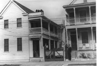
House on Coming Street near Sheppard Street, on site affected by the construction of Interstate 26 (I-26). Address: 276 Coming Street (L) and its neighbor, 274 Coming Street (R). Surveyor notations on back of photo: "Dkt.: 10.517. Property owner: William B. Hogan. Tract: 100. Station: 22+00 Rt. Northbound Lane Route 17. Date: March 5, 1963. Men on R/W (fence)." [See collection description for explanation of surveyor notations.]
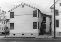
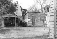
Sheds(?) and backyard of house, on site affected by the construction of Interstate 26 (I-26). Address: 94 Sheppard Street. Surveyor notations on back of photo: "Dkt.: 10.517. Property owner: Alice Davis. Tract: 101. Station: 23±55 Rt. Southbound Lane Route 17. Date: March 5, 1963. In R/W - Bought." [See collection description for explanation of surveyor notations.]
Limit your search
SCDOT Photographs: Properties in the Right-of-Way✖[remove]2,276