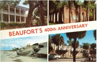
"Appeal to South Carolina Supreme Court: The City of Charleston v. Esau Jenkins. Includes published appeal to South Carolina Supreme Court requesting dismissal of Jenkins' 1962 conviction for selling alcohol after hours."
Newspaper printed for the civilian employees of the Charleston Naval Shipyard starting on January 19th 1962. This volume covers from January 19th 1962 to December 21st 1962.
University of Wisconsin Rural CAP Training Program course material entitled, "Sensitivity Training," excerpted from a paper by Wechsler, Massarik, and Tannenbaum.
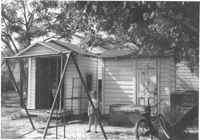
Two sheds and swing set, with standing girl, on site affected by the construction of Interstate 26 (I-26). Address: 2124 Weaver Avenue. Surveyor notations on back of photo: "Dkt.: 10.490. Property owner: Harry L. Rumph, Jr. Tract: 188. Station: 30' Lt. Sta. 5886-55. Date: May 15, 1962. In R/W - Bought." [See collection description for explanation of surveyor notations.]
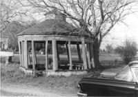
Gazebo, on site affected by the widening of Route 171 (Folly Road). Surveyor notations on back of photo: "Dkt.: 10.494. Property owner: Sophie Sabel, Est. Tract: 97. Station: 370+50 Lt. Date: Mar. 21, 1962. In R/W - Bought. [See collection description for explanation of surveyor notations.]
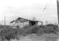
Dilapidated wood-sided structure on site affected by the construction of Interstate 26 (I-26). On grounds with many power lines on property. On Meeting Street/Meeting Street Road Surveyor notations on back of photo: "Dkt.: 10.510. Property owner: Geo. Fabian, Jr. Tract: 67. Station: 5796+10 on CL Lt. (Meeting Street). Date: Sept. 12, 1962. In R/W - Bought." [See collection description for explanation of surveyor notations.]
House on or in vicinity of King Street Extn., on site affected by the construction of Interstate 26 (I-26). Surveyor notations on back of photo: "Dkt.: 10.490. Property owner: V.C. Chemical Co. Tract: 1. Station: 5808+00 Lt. (Line F). Date: September 11, 1962. Partially in R/W." [See collection description for explanation of surveyor notations.]
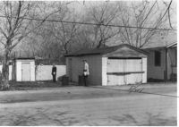
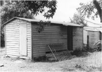
Garage and shed on site affected by the construction of Interstate 26 (I-26). Surveyor notations on back of photo: "Dkt.: 10.490. Property owner: Mostester Brown [Mostester Brown?]. Tract: 87-C. Station: 5825+45 Rt. Date: March 22, 1962. In R/W - Bought." [See collection description for explanation of surveyor notations.]
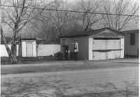
Garage and shed on site affected by the construction of Interstate 26 (I-26). Surveyor notations on back of photo: "Dkt.: 10.490. Property owner: Mostester Brown [Montester Brown?]. Tract: 87-C. Station: 5825+45 Rt. [Undated.] In R/W - Bought." [See collection description for explanation of surveyor notations.]
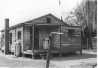
House on site affected by the construction of Interstate 26 (I-26). Building address number 208. Surveyor notations on back of photo: "Dkt.: 10.490. Property owner: Cora L. Gantt, et al. Tract: 65. Station: 5802+90 Lt. Line 'F'. Date: September 12, 1962. In R/W - Bought." [See collection description for explanation of surveyor notations.]
House (rear view) on site affected by the construction of Interstate 26 (I-26). Surveyor notations on back of photo: "Dkt.: 10.490. Property owner: E.S. Lapine, et al. Tract: 60. Station: 5801+40 Rt. Line 'G'. Date: September 12, 1962. In R/W - Bought." [See collection description for explanation of surveyor notations.]
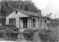
House (rear view) on site affected by the construction of Interstate 26 (I-26). Surveyor notations on back of photo: "Dkt.: 10.490. Property owner: Leah D. Governor. Tract: 58. Station: 5800+70 Lt. Line 'G'. Date: September 12, 1962. In R/W - Bought." [See collection description for explanation of surveyor notations.]
House (rear view) on site affected by the construction of Interstate 26 (I-26). Surveyor notations on back of photo: "Dkt.: 10.490. Property owner: F.F. Bellinger, et al. Tract: 61. Station: 5801+20 Rt. Line 'G'. Date: September 12, 1962. Proximity." [See collection description for explanation of surveyor notations.]
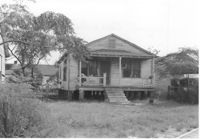
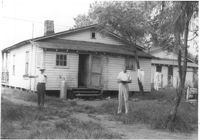
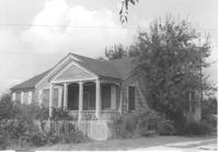
House and structures on site affected by the construction of Interstate 26 (I-26). Surveyor notations on back of photo: "Dkt.: 10.490. Property owner: E.S. Lapine, et al. Tract: 59. Station: 5800+80 Rt. Line 'G'. Date: September 12, 1962. In R/W - Bought." [See collection description for explanation of surveyor notations.]
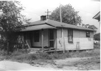
House on site affected by the construction of Interstate 26 (I-26). Surveyor notations on back of photo: "Dkt.: 10.490. Property owner: Leah D. Governor. Tract: 58. Station: 5800+70 Lt. Line 'G'. Date: September 12, 1962. In R/W - Bought." [See collection description for explanation of surveyor notations.]
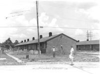
Multi-family housing on Pickens Street (306 Pickens Street), on site affected by the construction of Interstate 26 (I-26). Surveyor notations on back of photo: "Dkt.: 10.490. Property owner: Ashley Development Co. Tract: 1-A. Station: 5769+75 to 5771+25 Lt. Date: September 11, 1962. To be cut off at R/W line by owner." [See collection description for explanation of surveyor notations.]
Shed on site affected by the construction of Interstate 26 (I-26). Address: 2130 Montford Avenue. Surveyor notations on back of photo: "Dkt.: 10.490. Property owner: Rosa Lee Knight. Tract: 173. Station: 5884+00 Lt. Date: May 15, 1962. In R/W - Bought." [See collection description for explanation of surveyor notations.]
House on or in vicinity of King Street Extn., on site affected by the construction of Interstate 26 (I-26). Surveyor notations on back of photo: "Dkt.: 10.490. Property owner: V.C. Chemical Co. Tract: 1. Station: 5808+50 Rt. (Line F). Date: September 11, 1962. In R/W - Bought." [See collection description for explanation of surveyor notations.]