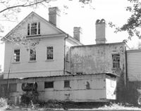
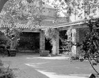
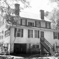
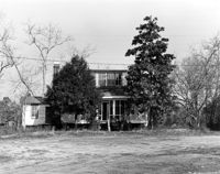
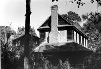
Barnwell House (Prospect Hill Plantation), Sugar Hill Road. View of East (Side) elevation. Hollywood, S.C.;8" x 10" B/W photo. Box 16, Folder 2-11-5. One copy.
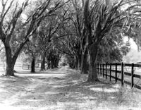
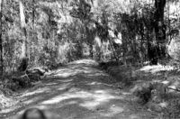
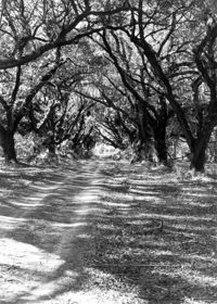
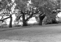
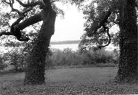
Wedge Plantation (William Lucas House), Wedge Plantation Road. View of Oak Allee. McClellanville, S.C.;8" x 10" B/W photo. Box 15, Folder 2-10-6. One copy.
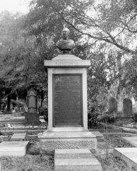
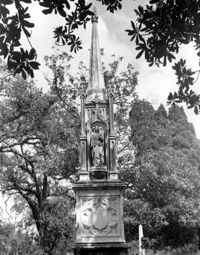
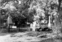
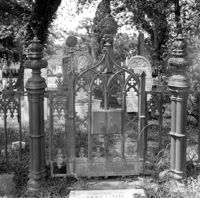
Magnolia Cemetery, Huguenin Avenue and Algonquin Road. Monument of William Ashmead Courtenay. View of Front elevation. Charleston, S.C.;10" x 8" B/W photo. Box 5, Folder 2-1-3. One copy.
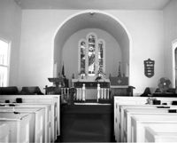
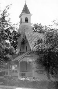
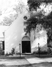
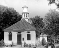
Christ Church Episcopal - Adams Run, State Highway 174. View of Interior. West (Front) elevation. Hollywood, S.C.;8" x 10" B/W photo. Box 16, Folder 2-11-12. One copy.
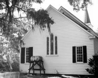
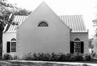
Christ Church Episcopal - Adams Run, State Highway 174. View of East (Rear) elevation. Hollywood, S.C.;8" x 10" B/W photo. Box 16, Folder 2-11-12. One copy.
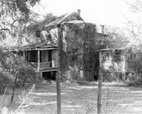
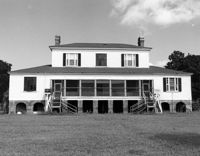
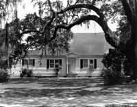
Old House Plantation, Clark Road. Main House - View of SE (Side and Rear) elevation. Edisto Island, S.C.;8" x 10" B/W photo. Box 11, Folder 2-3-10. One copy.
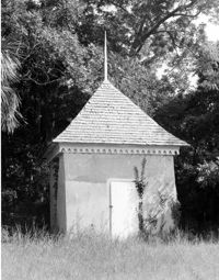
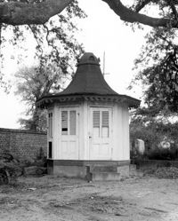
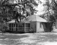
Bleak Hall Plantation, S.C. Hwy. 174. Smoke House - View of SW (Front) elevation. Edisto Island, S.C.;10" x 8" B/W photo. Box 10, Folder 2-3-2. One copy.
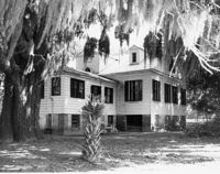
Old House Plantation, Clark Road. Main House - View of North (Front) elevation. Edisto Island, S.C.;8" x 10" B/W photo. Box 11, Folder 2-3-10. One copy.
Magnolia Cemetery, Huguenin Avenue and Algonquin Road. Monument of Sarah F., Charles F., and Elbert P. Jones. View of North elevation. Charleston, S.C.;10" x 8" B/W photo. Box 5, Folder 2-1-3. One copy.
How Tavern, ca. 1744. View of North (Front) elevation. Cainhoy (Huger vicinity, Lewisville, Louisville), S.C.;8" x 10" B/W photo. Box 4, Folder 1-12-3. One copy.
Church of the Redeemer (Pineville Chapel), Matilda Circle. View of SE (Rear and Side) elevation. Pineville Historic District. Pineville, SC.;6.5" x 9.5" B/W photo. Box 3, Folder 1-9-1 (I). One copy.
Church of the Redeemer (Pineville Chapel), Matilda Circle. View of SE (Side and Rear) elevation. Pineville Historic District. Pineville, SC.;6.5" x 9.5" B/W photo. Box 3, Folder 1-9-1 (I). One copy.
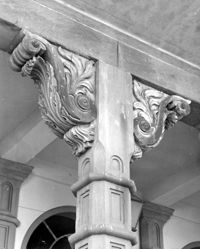
Dock Street Theater, 135 Church Street. Detail View of Porch Column. West (Front) elevation. Charleston, S.C.;10" x 8" B/W photo. Box 6, Folder 2-1-32. One copy.
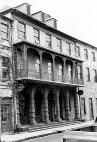
Dock Street Theater, 135 Church Street. View of NW (Front) elevation, looking West. Charleston, S.C.;10" x 6.5" B/W photo. Box 6, Folder 2-1-32. One copy.
Dock Street Theater, 135 Church Street. View of NW (Front) elevation, looking West. Charleston, S.C.;6.5" x 10" B/W photo. Box 6, Folder 2-1-32. One copy.
Rockville Historic District - Rockville Presbyterian Church, 2479 Sea Island Yacht Club Road. View of South (Front) elevation. Wadmalaw Island, S.C.;8" x 10" B/W photo. Box 17, Folder 2-14-10. One copy.
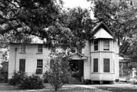
Rockville Historic District - John F. Sosnowski House, Grace Chapel Road. View of SW (Front and Side) elevation. Wadmalaw Island, S.C.;8" x 10" B/W photo. Box 17, Folder 2-14-21. One copy.
Rockville Historic District - John F. Sosnowski House, Grace Chapel Road. View of South (Front) elevation. Wadmalaw Island, S.C.;8" x 10" B/W photo. Box 17, Folder 2-14-21. One copy.
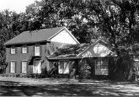
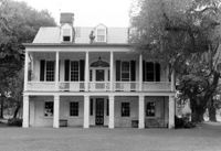
Dr. Morton Waring House - Main House. View of South (Rear) elevation, looking East. Pinopolis Historic District South. Pinopolis, S.C.;6.5" x 9.5" B/W photo. Box 4, Folder 1-10-1 (III). Two copies.
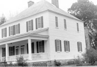
Dr. Morton Waring House - Main House. View of NW (Front and Side) elevation. Pinopolis Historic District South. Pinopolis, S.C.;6.5" x 9.5" B/W photo. Box 4, Folder 1-10-1 (III). Two copies.
Rockville Historic District - Welch's Lane House (Welches Lane House), Sea Island Yacht Club Road. View of SE (Front and Side) elevation. Wadmalaw Island, S.C.;8" x 10" B/W photo. Box 17, Folder 2-14-24. One copy.
Rockville Historic District - Edward D. Bailey House, Sea Island Yacht Club Road. View of East (Front) elevation. Wadmalaw Island, S.C.;6.5" x 10" (and 8" x 10") B/W photo. Box 17, Folder 2-14-23. Two copies.
Rockville Historic District - Presbyterian Manse, Sea Island Yacht Club Road. View of South (Front) elevation. Wadmalaw Island, S.C.;8" x 10" B/W photo. Box 17, Folder 2-14-22. One copy.
Rockville Historic District - Fanny Wilson House, Grace Chapel Road. View of South (Front) elevation. Wadmalaw Island, S.C.;6.5" x 10" B/W photo. Box 17, Folder 2-14-20. One copy.
Mount Pleasant Presbyterian Church (Trinity Methodist Church, Hibben Methodist Church, Mount Pleasant Seventh Day Adventist Church), corner of Hibben and Bennet Streets. View of South (Front) elevation. Mount Pleasant, S.C.;6.5" x 10" B/W photo. Box 13, Folder 2-8-1. One copy.
Mount Pleasant Presbyterian Church (Trinity Methodist Church, Hibben Methodist Church, Mount Pleasant Seventh Day Adventist Church), corner of Hibben and Bennet Streets.View of North (Side) elevation. Mount Pleasant, S.C.;10" x 6.5" B/W photo. Box 13, Folder 2-8-2. One copy.
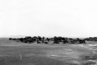
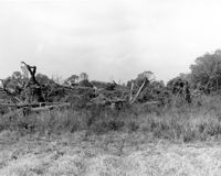
Folly Island Staging Area (Battery Green, U.S. Coast Guard Loran Station, Folly North Site), Address restricted. View facing WNW. Folly Beach, S.C.;8" x 10" B/W photo. Box 17, Folder 2-16-1. One copy.
Rockville Historic District - Cornelia J. Whaley House, Grace Chapel Road. View of South (Front) elevation. Wadmalaw Island, S.C.;6.5" x 10" B/W photo. Box 17, Folder 2-14-19. One copy.
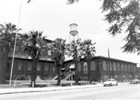
Magnolia Cemetery, Huguenin Avenue and Algonquin Road. Chapel - View of Side and Rear elevation. Charleston, S.C.;10" x 8" B/W photo. Box 5, Folder 2-1-3. One copy.
William Cain House - Main House. Detail View of Rear Door and Windows, South (Rear) elevation, looking East. Pinopolis Historic District North. Pinopolis, S.C.;6.5" x 9.5" B/W photo. Box 4, Folder 1-10-1 (III). Two copies.
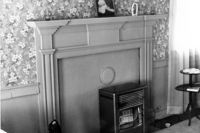
Old Rectory (Gourdin House). Interior View - Detail of Mantle on West Side, 2nd Floor. WNW elevation. Pineville Historic District. St. Stephen, SC.;6.5" x 9.5" B/W photo. Box 3, Folder 1-9-1 (I). One copy.
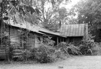
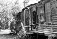
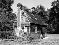
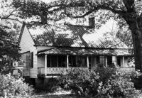
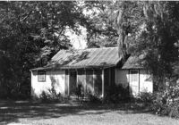
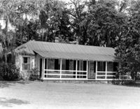
Old House Plantation, Clark Road. Slave Cabin - View of North (Side and Front) elevation. Edisto Island, S.C.;8" x 10" B/W photo. Box 11, Folder 2-3-10. One copy.
Middleton's Plantation (Chisolm's Plantation; The Launch), S.C. Hwy. 174. View of North (Rear) elevation. Edisto Island, S.C.;8" x 10" B/W photo. Box 11, Folder 2-3-9. One copy.
Middleton's Plantation (Chisolm's Plantation; The Launch), S.C. Hwy. 174. View of South (Front) elevation. Edisto Island, S.C.;8" x 10" B/W photo. Box 11, Folder 2-3-9. Two copies.
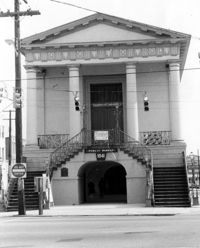
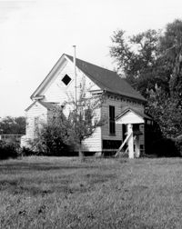
Old Lincolnville Town Hall (Williams Graded School), near intersection of East Randolph Street and East Pinckney Street. View of SE (Front and Side) elevation. Lincolnville, S.C.;6.5" x 10" B/W photo. Box 17, Folder 2-15-2. Three copies.
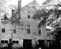
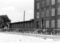
Cigar Factory, 701 East Bay Street. View of single story addition to main building, NW (Rear) elevation, looking South. Charleston, S.C.;7" x 10" B/W photo. Box 9, Folder 2-1-221. One copy.
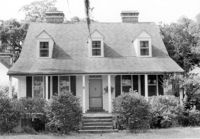
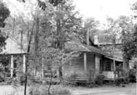
Unidentified House, ca. Mid 20th century - Non-contributory to Historic District. Front and Side elevations. Pinopolis, S.C.;5" x 7" B/W photo. Box 3, Folder 1-10-1 (II). One copy.
Cigar Factory, 701 East Bay Street. General View of Main Entrance (from Columbus Street), South (Side) elevation. Charleston, S.C.;7" x 10" B/W photo. Box 9, Folder 2-1-221. One copy.
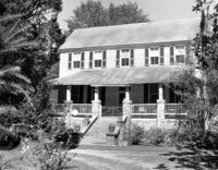
John Grant House, ca. 1901 - Pivotal to Historic District. View of front and Side elevations. Pinopolis Historic District South. Pinopolis, S.C.;5" x 7" B/W photo. Box 3, Folder 1-10-1 (II). One copy.
Post Office Building, ca. 1970 - Non-contributory to Historic District. Front and Side elevations. Pinopolis, S.C.;5" x 7" B/W photo. Box 3, Folder 1-10-1 (II). One copy.
Isaac Porcher Office, ca. 1844 - Pivotal to Historic District. View of Side elevation. Pinopolis, S.C.;5" x 7" B/W photo. Box 3, Folder 1-10-1 (II). One copy.
C.M. Loftan House (ca. 1911), Oak Street. View of Front elevation. McClellanville Historic District. McClellanville, S.C.;6.5" x 10" B/W photo. Box 14, Folder 2-10-5. One copy.
How Tavern. View of North (Front) elevation. Cainhoy (Huger vicinity, Lewisville, Louisville), S.C.;8" x 10" B/W photo. Box 4, Folder 1-12-3. One copy.
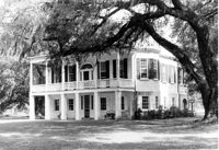
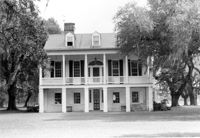
The Grove Plantation (Ernest F. Hollings ACE Basin National Wildlife Refuge). View of SE (Front and Side) elevation. Adams Run, S.C.;6.5" x 10" (and 8" x 10") B/W photo. Box 15, Folder 2-11-1. Two copies.
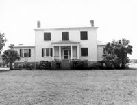
The Grove Plantation (Ernest F. Hollings ACE Basin National Wildlife Refuge). View of South (Front) elevation. Adams Run, S.C.;6.5" x 10" B/W photo. Box 15, Folder 2-11-1. Three copies.
The Grove Plantation (Ernest F. Hollings ACE Basin National Wildlife Refuge). View of South (Front) elevation. Adams Run, S.C.;6.5" x 10" B/W photo. Box 15, Folder 2-11-1. One copy.
William Cain House, ca. 1834 - Pivotal to Historic District. View of Side and Front elevations. Pinopolis Historic District North. Pinopolis, S.C.;5" x 7" B/W photo. Box 3, Folder 1-10-1 (II). One copy.
Unidentified House, ca. Early 20th century - Contributory to Historic District. Front elevation. Pinopolis, S.C.;5" x 7" B/W photo. Box 3, Folder 1-10-1 (II). One copy.
Unidentified House, ca. 1910 - Contributory to Historic District. Front elevation. Pinopolis Historic District South. Pinopolis, S.C.;5" x 7" B/W photo. Box 3, Folder 1-10-1 (II). One copy.
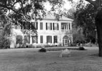
Lowndes Grove Plantation, 260 St. Margaret Street. Main House - View of East (Side) elevation. Charleston, S.C.;6.5" x 10" B/W photo. Box 8, Folder 2-1-148. One copy.
Lowndes Grove Plantation, 260 St. Margaret Street. View of Ashley River, West elevation. Charleston, S.C.;6.5" x 10" B/W photo. Box 8, Folder 2-1-148. One copy.
Lowndes Grove Plantation, 260 St. Margaret Street. View of Ashley River, West elevation. Charleston, S.C.;6.5" x 10" B/W photo. Box 8, Folder 2-1-148. One copy.
Dean Hall Plantation - Main House. View of NW (Front) elevation. Oakley, SC. NOTE: Property relocated to Beaufort County in 1971.;8" x 10" B/W photo. Box 2, Folder 1-8-8. One copy.
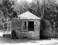
Middleburg Plantation, Middleburg Lane. Commissary - View of Front and Side elevation. Huger, S.C.;6.5" x 9.5" B/W photo. Box 4, Folder 1-12-4. One copy.
The Grove Plantation (Ernest F. Hollings ACE Basin National Wildlife Refuge). View of Outbuildings. Adams Run, S.C.;6.5" x 10" B/W photo. Box 15, Folder 2-11-1. One copy.
The Grove Plantation (Ernest F. Hollings ACE Basin National Wildlife Refuge). View of Property. Adams Run, S.C.;6.5" x 10" B/W photo. Box 15, Folder 2-11-1. Two copies.
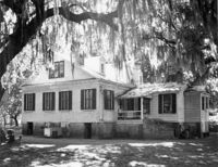
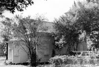
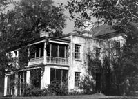
Barnwell House (Prospect Hill Plantation), Sugar Hill Road. View of NW (Side and Rear) elevation. Hollywood, S.C.;10" x 8" B/W photo. Box 16, Folder 2-11-5. One copy.
Barnwell House (Prospect Hill Plantation), Sugar Hill Road. View of NW (Rear and Side) elevation. Hollywood, S.C.;8" x 10" B/W photo. Box 16, Folder 2-11-5. One copy.
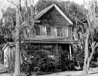
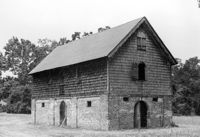
Wedge Plantation (William Lucas House), Wedge Plantation Road. Outbuilding #2 - View of Rear and Side elevation. McClellanville, S.C.;8" x 10" B/W photo. Box 15, Folder 2-10-6. One copy.
Henry M. Loftan, Jr. House (ca. 1901). View of Front elevation. McClellanville Historic District. McClellanville, S.C.;6.5" x 10" B/W photo. Box 14, Folder 2-10-5. One copy.
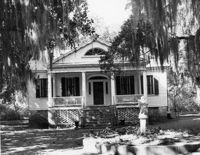
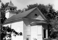
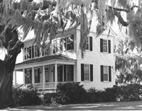
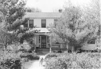
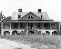
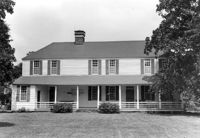
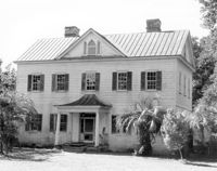
Barnwell House (Prospect Hill Plantation), Sugar Hill Road. View of South (Front) elevation. Hollywood, S.C.;8" x 10" B/W photo. Box 16, Folder 2-11-5. One copy.
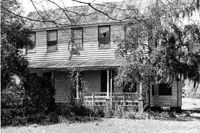
Wedge Plantation (William Lucas House), Wedge Plantation Road. Main House - View of Front addition. McClellanville, S.C.;10" x 8" B/W photo. Box 15, Folder 2-10-6. One copy.
St. Andrews Episcopal Church (Old St. Andrews Parish Church), 2604 Ashley River Road. View of West (Rear) elevation. Charleston, S.C.;6.5" x 10" B/W photo. Box 14, Folder 2-9-7. One copy.
St. Andrews Episcopal Church (Old St. Andrews Parish Church), 2604 Ashley River Road. View of East (Front) elevation. Charleston, S.C.;10" x 8" B/W photo. Box 14, Folder 2-9-7. One copy.
St. Andrews Episcopal Church (Old St. Andrews Parish Church), 2604 Ashley River Road. Interior View - North Entrance. North elevation. Charleston, S.C.;10" x 6.5" B/W photo. Box 14, Folder 2-9-7. One copy.
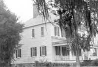
Christ Church (Christ Episcopal Church), 2304 U.S. Highway 17. View of North (Front) elevation. Mount Pleasant, S.C.;8" x 10" B/W photo. Box 10, Folder 2-2-6. One copy.
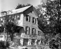
Oakland Plantation (Youghall Plantation), 1164 Porcher Bluff Road. Main House - View of SW (Side and Rear) elevation. Mount Pleasant, S.C.;10" x 8" B/W photo. Box 10, Folder 2-2-10. One copy.
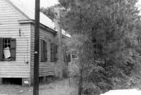
Oakland Plantation (Youghall Plantation), 1164 Porcher Bluff Road. Kitchen House - View of NE (Front) elevation. Mount Pleasant, S.C.;6.5" x 10" B/W photo. Box 10, Folder 2-2-10. One copy.