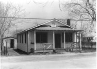
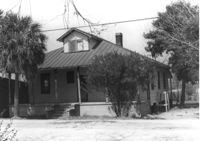
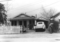
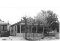
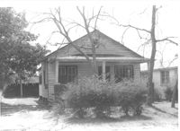
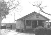
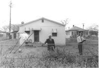
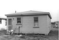
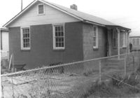
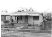
House on site affected by the construction of Interstate 26 (I-26). Surveyor notations on back of photo: "Dkt.: 10.490. Property owner: Geo. L. Robertson [George L. Robertson]. Tract: 87. Station: 5825+30 Rt. Date: March 22, 1962. In R/W - Bought." [See collection description for explanation of surveyor notations.]
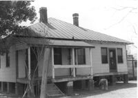
House (rear view) on site affected by the construction of Interstate 26 (I-26). Surveyor notations on back of photo: "Dkt.: 10.490. Property owner: Geo. L. Robertson [George L. Robertson]. Tract: 87. Station: 5825+30 Rt. Date: March 22, 1962. In R/W - Bought." [See collection description for explanation of surveyor notations.]
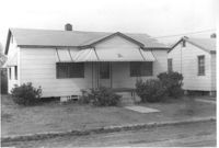
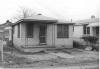
House on site affected by the construction of Interstate 26 (I-26). Surveyor notations on back of photo: "Dkt.: 10.490. Property owner: Geo. L. Robertson [George L. Robertson]. Tract: 87. Station: 5825+30 Rt. Date: May 15, 1962. In R/W - Bought." [See collection description for explanation of surveyor notations.]
House (rear view) on site affected by the construction of Interstate 26 (I-26). Surveyor notations on back of photo: "Dkt.: 10.490. Property owner: Geo. L. Robertson [George L. Robertson]. Tract: 87. Station: 5825+30 Rt. Date: May 15, 1962. In R/W - Bought." [See collection description for explanation of surveyor notations.]
House and portion of lot, on site affected by the construction of Interstate 26 (I-26). View partially obscured by trees. Surveyor notations on back of photo: "Dkt.: 10.490. Property owner: Geo. L. Robertson [George L. Robertson]. Tract: 87. Station: 5824+80 Rt. Date: May 15, 1962. In R/W - Bought." [See collection description for explanation of surveyor notations.]
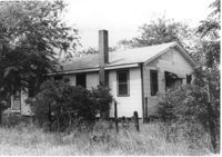
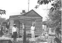
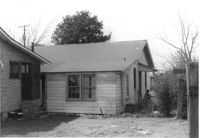
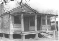
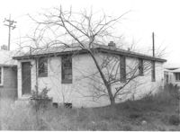
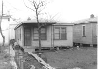
House (freedman's cottage) (rear view) on site affected by the construction of Interstate 26 (I-26). Surveyor notations on back of photo: "Dkt.: 10.490. Property owner: Ruth M. Bontz. Tract: 87-A. Station: 5824+80 Rt. Date: March 22, 1962. Proximity." [See collection description for explanation of surveyor notations.]
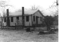
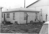
House (freedman's cottage) (rear view) on site affected by the construction of Interstate 26 (I-26). Surveyor notations on back of photo: "Dkt.: 10.490. Property owner: Martha Robinson, Est. Tract: 87-B. Station: 5825+00 Rt. Date: August 29, 1962. Proximity." [See collection description for explanation of surveyor notations.]
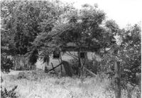
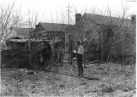
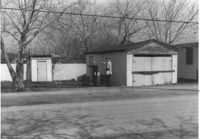
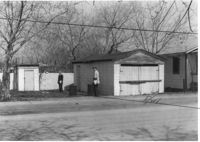
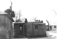
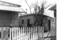
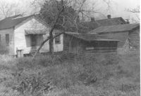
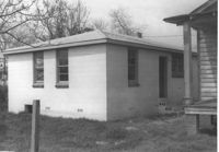
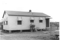
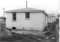
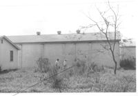
Garage and shed on site affected by the construction of Interstate 26 (I-26). Surveyor notations on back of photo: "Dkt.: 10.490. Property owner: Mostester Brown [Montester Brown?]. Tract: 87-C. Station: 5825+45 Rt. [Undated.] In R/W - Bought." [See collection description for explanation of surveyor notations.]
Garage and shed on site affected by the construction of Interstate 26 (I-26). Surveyor notations on back of photo: "Dkt.: 10.490. Property owner: Mostester Brown [Mostester Brown?]. Tract: 87-C. Station: 5825+45 Rt. Date: March 22, 1962. In R/W - Bought." [See collection description for explanation of surveyor notations.]
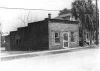
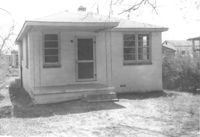
Building, perhaps once used commercially (market?), on site affected by the construction of Interstate 26 (I-26). Building address number 2212(?). Side facade has stepped parapet. Surveyor notations on back of photo: "Dkt.: 10.490. Property owner: F.F. Bellinger. Tract: 88. Station: 5825+40 Rt. Date: March 22, 1962. In R/W - Bought." [See collection description for explanation of surveyor notations.]
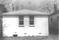
Building (rear view), perhaps once used commercially (market?), on site affected by the construction of Interstate 26 (I-26). Side facade has stepped parapet. [Building address number 2212(?).] Surveyor notations on back of photo: "Dkt.: 10.490. Property owner: F.F. Bellinger. Tract: 88. Station: 5825+40 Rt. Date: March 22, 1962. In R/W - Bought." [See collection description for explanation of surveyor notations.]
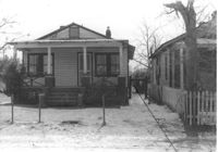
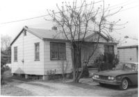
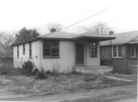
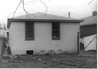
House on site affected by the construction of Interstate 26 (I-26). Surveyor notations on back of photo: "Dkt.: 10.490. Property owner: H.T. Sturken, et al. Tract: 89. Station: 5825+40 Lt. Date: March 22, 1962. In R/W - Bought." [See collection description for explanation of surveyor notations.]
House (rear view) on site affected by the construction of Interstate 26 (I-26). Small pony grazing nearby. Surveyor notations on back of photo: "Dkt.: 10.490. Property owner: H.T. Sturken, et al. Tract: 89. Station: 5825+40 Lt. Date: March 22, 1962. In R/W - Bought." [See collection description for explanation of surveyor notations.]
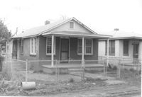
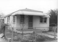
House on site affected by the construction of Interstate 26 (I-26). Surveyor notations on back of photo: "Dkt.: 10.490. Property owner: Buddy Floyd, et al. Tract: 90. Station: 5825+10 Lt. Date: March 22, 1962. In R/W - Bought." [See collection description for explanation of surveyor notations.]
House (corner view, rear) on site affected by the construction of Interstate 26 (I-26). Surveyor notations on back of photo: "Dkt.: 10.490. Property owner: Buddy Floyd, et al. Tract: 90. Station: 5825+10 Lt. Date: March 22, 1962. In R/W - Bought." [See collection description for explanation of surveyor notations.]
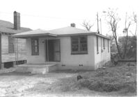
House on site affected by the construction of Interstate 26 (I-26). Surveyor notations on back of photo: "Dkt.: 10.490. Property owner: Harold C. Parrish. Tract: 90-A. Station: 5825+40 Lt. Date: March 22, 1962. In R/W - Bought." [See collection description for explanation of surveyor notations.]
House (corner view, rear) on site affected by the construction of Interstate 26 (I-26). Surveyor notations on back of photo: "Dkt.: 10.490. Property owner: Harold C. Parrish. Tract: 90-A. Station: 5825+40 Lt. Date: March 22, 1962. In R/W - Bought." [See collection description for explanation of surveyor notations.]
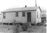
House on site affected by the construction of Interstate 26 (I-26). Surveyor notations on back of photo: "Dkt.: 10.490. Property owner: Minnie R. Sherman. Tract: 91. Station: 5826+70 Lt. Date: March 22, 1962. In R/W - Bought." [See collection description for explanation of surveyor notations.]
House (portion, rear view) and shed on site affected by the construction of Interstate 26 (I-26). Surveyor notations on back of photo: "Dkt.: 10.490. Property owner: Minnie R. Sherman. Tract: 91. Station: 5826+70 Lt. Date: March 22, 1962. In R/W - Bought." [See collection description for explanation of surveyor notations.]
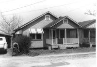
House on site affected by the construction of Interstate 26 (I-26). Surveyor notations on back of photo: "Dkt.: 10.490. Property owner: Lottie M. Heinsohn. Tract: 91-A. Station: 5826+70 Lt. Date: March 22, 1962. Proximity." [See collection description for explanation of surveyor notations.]
House (rear view) and yard on site affected by the construction of Interstate 26 (I-26). Surveyor notations on back of photo: "Dkt.: 10.490. Property owner: Lottie M. Heinsohn. Tract: 91-A. Station: 5826+70 Lt. Date: March 22, 1962. Proximity." [See collection description for explanation of surveyor notations.]
House on site affected by the construction of Interstate 26 (I-26). Surveyor notations on back of photo: "Dkt.: 10.490. Property owner: Minnie R. Sherman. Tract: 92. Station: 5826+60 Lt. Date: March 22, 1962. In R/W - Bought." [See collection description for explanation of surveyor notations.]
House (rear view) and shed on site affected by the construction of Interstate 26 (I-26). Surveyor notations on back of photo: "Dkt.: 10.490. Property owner: Minnie R. Sherman. Tract: 92. Station: 5827+10 Lt. Date: March 22, 1962. In R/W - Bought." [See collection description for explanation of surveyor notations.]
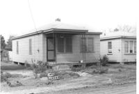
House on site affected by the construction of Interstate 26 (I-26). Surveyor notations on back of photo: "Dkt.: 10.490. Property owner: Minnie R. Sherman. Tract: 93. Station: 5826+55 Lt. Date: March 22, 1962. In R/W - Bought." [See collection description for explanation of surveyor notations.]
House (rear view) on site affected by the construction of Interstate 26 (I-26). Surveyor notations on back of photo: "Dkt.: 10.490. Property owner: Minnie R. Sherman. Tract: 93. Station: 5826+55 Lt. Date: March 22, 1962. In R/W - Bought." [See collection description for explanation of surveyor notations.]
House and shed at end of driveway, on site affected by the construction of Interstate 26 (I-26). Building address number 2215(?). Surveyor notations on back of photo: "Dkt.: 10.490. Property owner: Minnie R. Sherman. Tract: 94 & 95. Station: 5826+60 Rt. Date: March 22, 1962. In R/W - Bought." [See collection description for explanation of surveyor notations.]
House (rear view) on site affected by the construction of Interstate 26 (I-26). [Building address number 2215(?).] Surveyor notations on back of photo: "Dkt.: 10.490. Property owner: Minnie R. Sherman. Tract:95. Station: 5826+60 Rt. Date: March 22, 1962. In R/W - Bought." [See collection description for explanation of surveyor notations.]
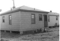
House on site affected by the construction of Interstate 26 (I-26). Surveyor notations on back of photo: "Dkt.: 10.490. Property owner: Minnie R. Sherman. Tract:96. Station: 5826+50 Rt. Date: March 22, 1962. In R/W - Bought." [See collection description for explanation of surveyor notations.]
House (corner view, rear) on site affected by the construction of Interstate 26 (I-26). Surveyor notations on back of photo: "Dkt.: 10.490. Property owner: Minnie R. Sherman. Tract:96. Station: 5826+50 Rt. Date: March 22, 1962. In R/W - Bought." [See collection description for explanation of surveyor notations.]
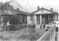
House (rear view) and backyard on site affected by the construction of Interstate 26 (I-26). Surveyor notations on back of photo: "Dkt.: 10.490. Property owner: Christer Bell King. Tract: 96-D. Station: 5826+95 Rt. Date: March 22, 1962. Proximity" [See collection description for explanation of surveyor notations.]
House on site affected by the construction of Interstate 26 (I-26). Surveyor notations on back of photo: "Dkt.: 10.490. Property owner: Freddie Alston, et al. Tract: 97. Station: 5827+75 Rt. Date: March 22, 1962. In R/W - Bought." [See collection description for explanation of surveyor notations.]
House (rear view) on site affected by the construction of Interstate 26 (I-26). Surveyor notations on back of photo: "Dkt.: 10.490. Property owner: Freddie Alston, et al. Tract: 97. Station: 5827+75 Rt. Date: March 22, 1962. In R/W - Bought." [See collection description for explanation of surveyor notations.]
House on site affected by the construction of Interstate 26 (I-26). Surveyor notations on back of photo: "Dkt.: 10.490. Property owner: W.L. Gaillard, et al. Tract: 98. Station: 5827+75 Rt. Date: March 22, 1962. In R/W - Bought." [See collection description for explanation of surveyor notations.]
House (rear view) on site affected by the construction of Interstate 26 (I-26). Surveyor notations on back of photo: "Dkt.: 10.490. Property owner: W.L. Gaillard, et al. Tract: 98. Station: 5827+75 Rt. Date: March 22, 1962. In R/W - Bought." [See collection description for explanation of surveyor notations.]
House on site affected by the construction of Interstate 26 (I-26). Surveyor notations on back of photo: "Dkt.: 10.490. Property owner: W.L. Gaillard, et al. Tract: 99. Station: 5827+75 Rt. Date: March 22, 1962. In R/W - Bought." [See collection description for explanation of surveyor notations.]
House (rear view) on site affected by the construction of Interstate 26 (I-26). Surveyor notations on back of photo: "Dkt.: 10.490. Property owner: W.L. Gaillard, et al. Tract: 99. Station: 5827+75 Rt. Date: March 22, 1962. In R/W - Bought." [See collection description for explanation of surveyor notations.]
House on site affected by the construction of Interstate 26 (I-26). Surveyor notations on back of photo: "Dkt.: 10.490. Property owner: W.L. Gaillard, et al. Tract: 100. Station: 5827+80 on CL. Date: March 22, 1962. In R/W - Bought." [See collection description for explanation of surveyor notations.]
House (rear view) on site affected by the construction of Interstate 26 (I-26). Surveyor notations on back of photo: "Dkt.: 10.490. Property owner: W.L. Gaillard, et al. Tract: 100. Station: 5827+80 on CL. Date: March 22, 1962. In R/W - Bought." [See collection description for explanation of surveyor notations.]
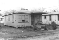
House on site affected by the construction of Interstate 26 (I-26). Surveyor notations on back of photo: "Dkt.: 10.490. Property owner: Harold I. Sherman. Tract: 101. Station: 5827+80 Lt. Date: March 22, 1962. In R/W - Bought." [See collection description for explanation of surveyor notations.]
House (corner view, rear) on site affected by the construction of Interstate 26 (I-26). Surveyor notations on back of photo: "Dkt.: 10.490. Property owner: Harold I. Sherman. Tract: 101. Station: 5827+80 Lt. Date: March 22, 1962. In R/W - Bought." [See collection description for explanation of surveyor notations.]
House on site affected by the construction of Interstate 26 (I-26). Building address number 2220. Surveyor notations on back of photo: "Dkt.: 10.490. Property owner: W.L. Gaillard, et al. Tract: 102. Station: 5827+85 Lt. Date: March 22, 1962. In R/W - Bought." [See collection description for explanation of surveyor notations.]
House (corner view, rear) on site affected by the construction of Interstate 26 (I-26). [Building address number 2220.] Surveyor notations on back of photo: "Dkt.: 10.490. Property owner: W.L. Gaillard, et al. Tract: 102. Station: 5827+85 Lt. Date: March 22, 1962. In R/W - Bought." [See collection description for explanation of surveyor notations.]
House on site affected by the construction of Interstate 26 (I-26). Surveyor notations on back of photo: "Dkt.: 10.490. Property owner: W.L. Gaillard, et al. Tract: 103. Station: 5827+90 Lt. Date: March 22, 1962. In R/W - Bought." [See collection description for explanation of surveyor notations.]
House (rear view) on site affected by the construction of Interstate 26 (I-26). Surveyor notations on back of photo: "Dkt.: 10.490. Property owner: W.L. Gaillard, et al. Tract: 103. Station: 5827+90 Lt. Date: March 22, 1962. In R/W - Bought." [See collection description for explanation of surveyor notations.]
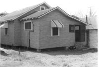
House on site affected by the construction of Interstate 26 (I-26). Building address number 2224. Surveyor notations on back of photo: "Dkt.: 10.490. Property owner: Mary Jane Graham. Tract: 103-A. Station: 5827+90 Lt. Date: March 22, 1962. Owner to clear R/W." [See collection description for explanation of surveyor notations.]
House on site affected by the construction of Interstate 26 (I-26). Building address number 2224. Surveyor notations on back of photo: "Dkt.: 10.490. Property owner: Mary Jane Graham. Tract: 103-A. Station: 5827+90 Lt. Date: March 22, 1962. Owner to clear R/W." [See collection description for explanation of surveyor notations.]
House (rear view) on site affected by the construction of Interstate 26 (I-26). [Building address number 2224.] Surveyor notations on back of photo: "Dkt.: 10.490. Property owner: Mary Jane Graham. Tract: 103-A. Station: 5827+90 Lt. Date: March 22, 1962. Owner to clear R/W." [See collection description for explanation of surveyor notations.]
House on site affected by the construction of Interstate 26 (I-26). Surveyor notations on back of photo: "Dkt.: 10.490. Property owner: Harold I. Sherman. Tract: 104. Station: 5829+00 Lt. Date: March 22, 1962. In R/W - Bought." [See collection description for explanation of surveyor notations.]
House (corner view, rear) on site affected by the construction of Interstate 26 (I-26). Surveyor notations on back of photo: "Dkt.: 10.490. Property owner: Harold I. Sherman. Tract: 104. Station: 5829+00 Lt. Date: March 22, 1962. In R/W - Bought." [See collection description for explanation of surveyor notations.]
Charleston Plywood and Lumber Co. building (side view) on site affected by the construction of Interstate 26 (I-26). Surveyor notations on back of photo: "Dkt.: 10.490. Property owner: Minnie R. Sherman. Tract: 104-B. Station: 5829+20 Lt. Date: August 29, 1962. End to be moved by SCHD [SC Highway Department]." [See collection description for explanation of surveyor notations.]