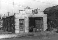
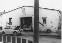
Building -- Simmons Garage -- on site affected by the construction of the Crosstown. Address: 76 Cooper Street or 78 Cooper Street. Front facade has stepped parapet. Surveyor notations on back of photo: "Dkt.: 10.518. Property owner: Helen Phillips Brown. Tract: 10. Station: 39+30 Rt. North Bound Survey of Route 17. Date: Mar. 6, 1963. In R/W - Bought. [See collection description for explanation of surveyor notations.]
Rear view of building -- Simmons Garage -- on site affected by the construction of the Crosstown. Address: 76 Cooper Street or 78 Cooper Street. Surveyor notations on back of photo: "Dkt.: 10.518. Property owner: Helen Phillips Brown. Tract: 10. Station: 39+30 Rt. North Bound Route 17 Lane. Date: Mar. 6, 1963. In R/W - Bought. [See collection description for explanation of surveyor notations.]
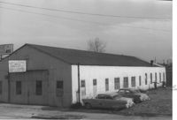
Ray Waits Mechanic/Body Shop (rear view) on site affected by the construction of Interstate 26 (I-26). Address: 11 Walnut Street. Surveyor notations on back of photo: "Dkt.: 10.517. Property owner: Roy Waites [sic] Motors, Inc. Tract: 45. Station: 5950+60 Lt. - Line 6. Date: February 21, 1963." [See collection description for explanation of surveyor notations.]
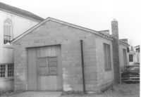
Ray Waits Mechanic/Body Shop (corner, one end of building, rear view) on site affected by the construction of Interstate 26 (I-26). Address: 11 Walnut Street. Surveyor notations on back of photo: "Dkt.: 10.517. Property owner: Roy Waites [sic] Motors, Inc. Tract: 45. Station: 5950±5950±67 Lt. Date: February 21, 1963." [See collection description for explanation of surveyor notations.]
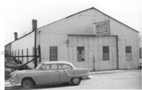
Ray Waits Mechanic/Body Shop (one end of building, front) on site affected by the construction of Interstate 26 (I-26). Address: 11 Walnut Street. Surveyor notations on back of photo: "Dkt.: 10.517. Property owner: Roy Waites [sic] Motors, Inc. Tract: 45. Station: 5950± Lt. - Line 6. Date: February 21, 1963." [See collection description for explanation of surveyor notations.]
Ray Waits Mechanic/Body Shop (one end of building, front) on site affected by the construction of Interstate 26 (I-26). Address: 11 Walnut Street. Surveyor notations on back of photo: "Dkt.: 10.517. Property owner: Roy Waites [sic] Motors, Inc. Tract: 45. Station: 5950+70 Rt. - Line 6. Date: February 21, 1963. All in R/W." [See collection description for explanation of surveyor notations.]
Ray Waits Mechanic/Body Shop on site affected by the construction of Interstate 26 (I-26). Address: 11 Walnut Street. Surveyor notations on back of photo: "Dkt.: 10.517. Property owner: Roy Waites [sic] Motors, Inc. Tract: 45. Station: 5950+55 Lt. - Line 6. Date: February 21, 1963." [See collection description for explanation of surveyor notations.]
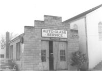
Collins Auto Glass Service on site affected by the construction of Interstate 26 (I-26). Address: 91 Lee Street. Front facade has stepped parapet. Surveyor notations on back of photo: "Dkt.: 10.517. Property owner: W.H. Yon. Tract: 56. Station: 34+30 Lt. - Route 17. Date: February 21, 1963." [See collection description for explanation of surveyor notations.]
Collins Auto Glass Service (rear view) on site affected by the construction of Interstate 26 (I-26). Address: 91 Lee Street. Surveyor notations on back of photo: "Dkt.: 10.517. Property owner: W.H. Yon. Tract: 56. Station: 34+30 Lt. - Route 17. Date: February 21, 1963." [See collection description for explanation of surveyor notations.]
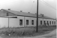
Garbini Auto Service -- General Auto Repair - Body and Paint Shop, on site affected by the construction of Interstate 26 (I-26). Address: 89 Lee Street. Surveyor notations on back of photo: "Dkt.: 10.517. Property owner: W.H. Yon. Tract: 56. Station: 35+20 CL - Route 17. Date: February 21, 1963. Partially in R/W." [See collection description for explanation of surveyor notations.]
Garbini Auto Service -- General Auto Repair - Body and Paint Shop, on site affected by the construction of Interstate 26 (I-26). Address: 89 Lee Street. Surveyor notations on back of photo: "Dkt.: 10.517. Property owner: W.H. Yon. Tract: 56. Station: 35+20 CL - Route 17. Date: February 21, 1963. Partially in R/W." [See collection description for explanation of surveyor notations.]
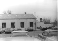
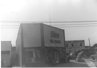
Gibson Tire Service on site affected by the construction of Interstate 26 (I-26). Address: 521 Meeting Street or 523 Meeting Street. Corner of Meeting Street and Lee Street. Surveyor notations on back of photo: "Dkt.: 10.517. Property owner: Thomas P. Gibson. Tract: 59. Station: 36+15 - 37+03 Rt. & Lt. Route 17. Date: February 21, 1963. All in R/W." [See collection description for explanation of surveyor notations.]
Gibson Tire Service on site affected by the construction of Interstate 26 (I-26). Address: 521 Meeting Street or 523 Meeting Street. Corner of Meeting Street and Lee Street. Surveyor notations on back of photo: "Dkt.: 10.517. Property owner: Thomas P. Gibson. Tract: 59. Station: 36+50 Rt. & Lt. Southbound Route 17. Date: May 30, 1963." [See collection description for explanation of surveyor notations.]
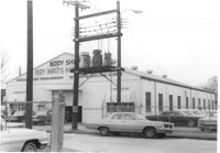
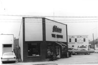
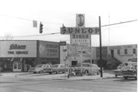
Gibson Tire Service on site affected by the construction of Interstate 26 (I-26). Address: 521 Meeting Street or 523 Meeting Street. Corner of Meeting Street and Lee Street. Sign for Dunlop Tires. View from street corner, showing intersection with directional signage for Route 17 and Route 701 and distances to nearby towns. Surveyor notations on back of photo: "Dkt.: 10.517. Property owner: Thomas P. Gibson. Tract: 59. Station: 36±00 - 37±00 Rt. & Lt. Route 17. Date: February 21, 1963. All in R/W." [See collection description for explanation of surveyor notations.]
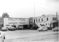
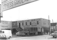
Gibson Tire Service / Hawkinson Treads on site affected by the construction of Interstate 26 (I-26). Address: 521 Meeting Street or 523 Meeting Street. Corner of Meeting Street and Lee Street. Surveyor notations on back of photo: "Dkt.: 10.517. Property owner: Thomas P. Gibson. Tract: 59. Station: 36+50 Rt. & Lt. Southbound Route 17. Date: May 30, 1963." [See collection description for explanation of surveyor notations.]
Gibson Tire Service / Hawkinson Treads on site affected by the construction of Interstate 26 (I-26). Address: 85 Lee Street. Corner of Lee Street and Meeting Street. Surveyor notations on back of photo: "Dkt.: 10.517. Property owner: Thomas P. Gibson. Tract: 59. Station: 36±00 - 37±00 Rt. & Lt. Route 17. Date: February 21, 1963. All in R/W." [See collection description for explanation of surveyor notations.]
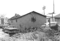
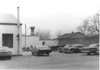
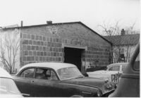
Bush's Auto Repair Shop (rear view) on site affected by the construction of Interstate 26 (I-26). Address: 44 Sheppard Street. Several cars in foreground. Surveyor notations on back of photo: "Dkt.: 10.517. Property owner: S.E. Jenkins. Tract: 71. Station: 5960+15 CL - Line 3. Date: March 5, 1963. In R/W - Bought." [See collection description for explanation of surveyor notations.]
Bush's Auto Repair Shop on site affected by the construction of Interstate 26 (I-26). Address: 44 Sheppard Street. Mechanics working on car in garage bay. Surveyor notations on back of photo: "Dkt.: 10.517. Property owner: S.E. Jenkins. Tract: 71. Station: 5960+15 CL - Line 3. Date: March 5, 1963. In R/W - Bought." [See collection description for explanation of surveyor notations.]
Right of way--South Carolina--Charleston County, Highway planning--South Carolina--Charleston County, Commercial buildings--South Carolina--Charleston County, Vernacular architecture--South Carolina--Charleston County, Lost architecture--South Carolina--Charleston County, Automobile repair shops--South Carolina--Charleston County✖[remove]18