Search
« Previous |
1 - 100 of 1,613
|
Next »
Search Results
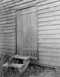
Date:
1977-1983
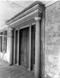
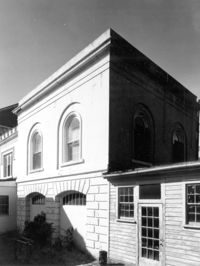
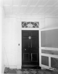
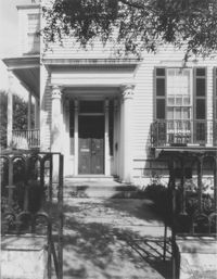
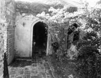
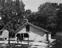
Description:
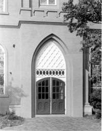
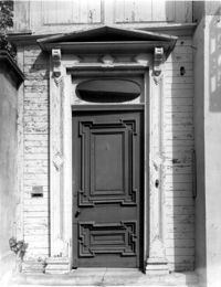
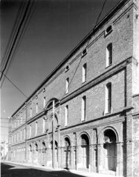
405 King Street, St. Matthews Lutheran Church, ca. 1867. Sunday School Building - Detail View of entry, East (Front) elevation. 4" x 5" B/W photo.
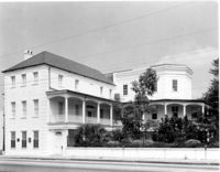
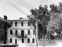
Date:
1977-1983
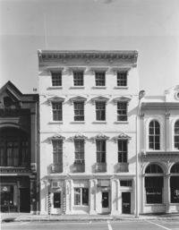
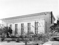
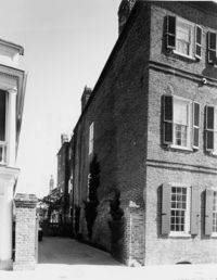
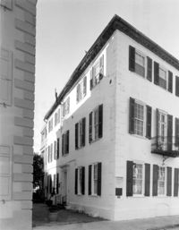
Description:
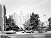
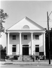
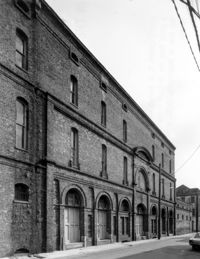
405 King Street, St. Matthews Lutheran Church, ca. 1867. Sunday School Building and Office Building - View of East (Front) elevation. 4" x 5" B/W photo.
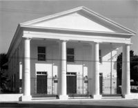
Date:
1977-1983
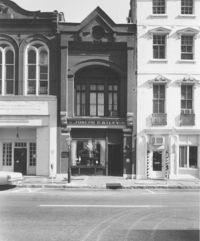
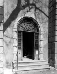
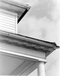
Description:
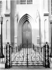
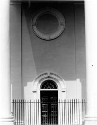
405 King Street, St. Matthews Lutheran Church, ca. 1867. Church - Detail View of center entry, East (Front) elevation. 4" x 5" B/W photo.
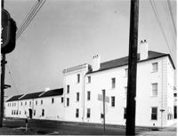
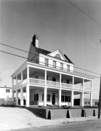
Date:
1977-1983
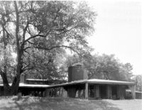
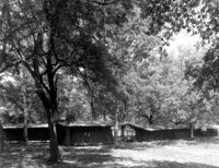
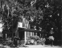
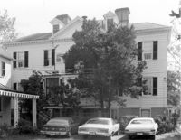
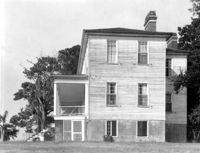
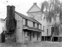
Description:
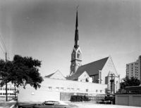
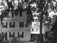
405 King Street, St. Matthews Lutheran Church, ca. 1867. Whole Proprty - View of NW (Rear and Side) elevation. 4" x 5" B/W photo.
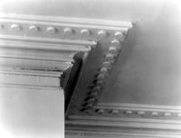
Date:
1977-1983
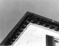
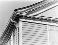
Description:
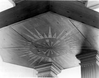
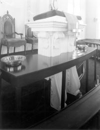
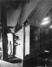
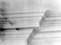
Berkeley County, St. Stephen's Church, ca. 1767. Detail View of soffitt in pulpit roof. 4" x 5" B/W photo.
Date:
1977-1983
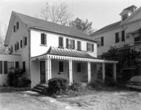
Description:
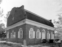
Berkeley County, St. Stephen's Church, ca. 1767. View of NE (Rear and Side) elevation. 4" x 5" B/W photo.
Date:
1977-1983
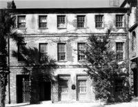
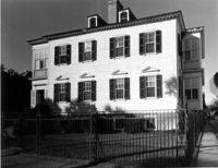
Description:
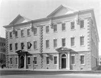
82 - 86 Broad Street, ca 1753. View of East (Front) elevation. 4" x 5" B/W photo.
Date:
1977-1983
Description:
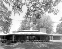
Beaufort County, Auldbrass Plantation, ca. 1951. Main House - View of Central Block, West elevation. 4" x 5" B/W photo.
Date:
1977-1983
Description:
Beaufort County, Auldbrass Plantation, ca. 1951. Main House - View of Bedroom Wing, SE elevation. 4" x 5" B/W photo.
Date:
1977-1983
Description:
15 Broad Street, Smith Building, ca. 1800-1815. View of North (Front) elevation. 4" x 5" B/W photo.
Date:
1977-1983
Description:
13 Broad Street, ca.1890. View of North (Front) elevation. 4" x 5" B/W photo.
Date:
1977-1983
Description:
48 Elizabeth Street, Aiken-Rhett House, ca.1818. Main House - Detail View of entry to 2nd Floor Hall, SW (Front and Side) elevation. 4" x 5" B/W photo.
Date:
1977-1983
Description:
48 Elizabeth Street, Aiken-Rhett House, ca.1818. Main House - Interior View. 1st Floor - NW Room, entry from street, West elevation. 4" x 5" B/W photo.
Date:
1977-1983
Description:
48 Elizabeth Street, Aiken-Rhett House, ca.1818. Main House - Detail View of entry to 1st Floor, NW (Rear and Side) elevation. 4" x 5" B/W photo.
Date:
1977-1983
Description:
48 Elizabeth Street, Aiken-Rhett House, ca.1818. Main House - Detail View of entry, West (Side) elevation. 4" x 5" B/W photo.
Date:
1977-1983
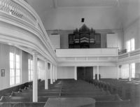
Description:
68 Spring Street, Karpeles Manuscript Library Museum (St. James United Methodist Church), ca. 1858. Interior View - Nave, looking South. 4" x 5" B/W photo.
Date:
1977-1983
Description:
68 Spring Street, Karpeles Manuscript Library Museum (St. James United Methodist Church), ca. 1858. Interior View - Detail of pulpit. 4" x 5" B/W photo.
Date:
1977-1983
Description:
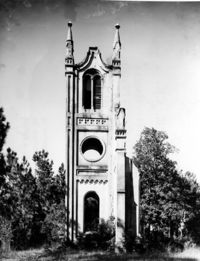
Georgetown County, Prince Frederick's Episcopal Church (Ruins), ca. 1859. View of South (Side) elevation. 4" x 5" B/W photo.
Date:
1977-1983
Description:
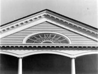
Charleston County, William Seabrook-Dodge Plantation, ca. 1810. Detail View of portico pediment, South (Front) elevation. 4" x 5" B/W photo.
Date:
1977-1983
Description:
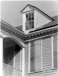
Charleston County, William Seabrook-Dodge Plantation, ca. 1810. Detail View of dormer and cornice, South (Front) elevation. 4" x 5" B/W photo.
Date:
1977-1983
Description:
Charleston County, William Seabrook-Dodge Plantation, ca. 1810. View of SW (Front and Side) elevation. 4" x 5" B/W photo.
Date:
1977-1983
Description:
Charleston County, William Seabrook-Dodge Plantation, ca. 1810. View of NW (Rear and Side) elevation. 4" x 5" B/W photo.
Date:
1977-1983
Description:
126 Coming Street, Cathedral Church of St. Luke and St. Paul, ca. 1816. Detail View of portico, West (Front) elevation. 4" x 5" B/W photo.
Date:
1977-1983
Description:
172 Rutledge Avenue, Ashley Hall, ca. 1802. Main House - Detail View of bay cornice, West (Side) elevation. 4" x 5" B/W photo.
Date:
1977-1983
Description:
172 Rutledge Avenue, Ashley Hall, ca. 1802. Main House - Detail View of bay, West (Side) elevation. 4" x 5" B/W photo.
Date:
1977-1983
Description:
172 Rutledge Avenue, Ashley Hall, ca. 1802. Carriage House - View of SE (Front and Side) elevation. 4" x 5" B/W photo.
Date:
1977-1983
Description:
133 Church Street, Planter's Hotel, ca. 1809. View of East (Front) elevation. 4" x 5" B/W photo.
Date:
1977-1983
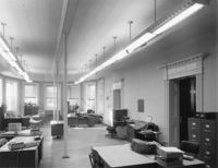
Description:
100 Meeting Street, Fireproof Building, ca. 1822. Interior View - 2nd Floor. Stair Hall - West corridor, East elevation. 4" x 5" B/W photo.
Date:
1977-1983
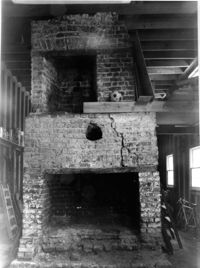
Description:
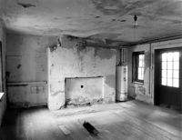
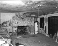
126 Tradd street, Dr. Peter Fayssoux House, ca. 1732. Kitchen House - Interior View. Detail of South fireplace without plaster. 4" x 5" B/W photo.
Date:
1977-1983
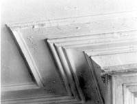
Description:
48 Elizabeth Street, Aiken-Rhett House, ca.1818. Main House - Interior View. 1st Floor - East Room. Detail of cornice and over mantle mirror frame. 4" x 5" B/W photo.
Date:
1977-1983
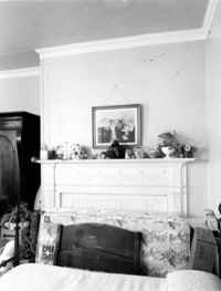
Description:
Berkley County, Loch Dhu, ca. 1812. Main House - Interior View. 1st Floor - NE Room, Detail of chimneypiece and mantel. 4" x 5" B/W photo.
Date:
1977-1983
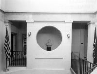
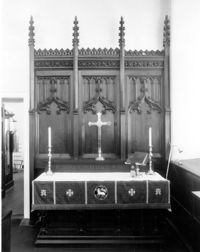
Description:
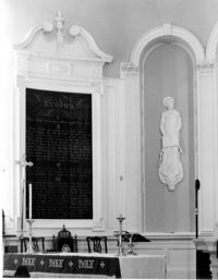
126 Coming Street, Cathedral Church of St. Luke and St. Paul, ca. 1816. Interior View - Detail view of altar from original St. Luke's Church (see #CNB_342 - CNB_344). 4" x 5" B/W photo.
Date:
1977-1983
Description:
Beaufort County, Auldbrass Plantation, ca. 1951. Stable, Groom's Room, Passage and Kennels (From Left to Right) - View of West elevation. 4" x 5" B/W photo.
Date:
1977-1983
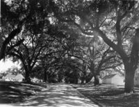
Description:
Georgetown County, Mansfield Plantation, ca. 1718. View of Oak Allee. 4" x 5" B/W photo.
Date:
1977-1983
Description:
60 Wentworth Street, Centenary Methodist Church, ca. 1842. View of NE (Side and Rear) elevation. 4" x 5" B/W photo.
Date:
1977-1983
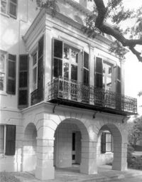
Description:
6 Gibbes Street, Parker-Drayton House, ca.1806. Detail View of Ground Floor East end entry, South (Front) elevation. 4" x 5" B/W photo.
Date:
1977-1983
Description:
100 Wentworth Street, Grace Episcopal Church, ca. 1847. View of West (Side) elevation. 4" x 5" B/W photo.
Date:
1977-1983
Description:
Charleston County, William Seabrook-Dodge Plantation, ca. 1810. View of North (Rear) elevation. 4" x 5" B/W photo.
Date:
1977-1983
Description:
Berkley County, Lewisfield, ca. 1744. View of South (Side) elevation. 4" x 5" B/W photo.
Date:
1977-1983
Description:
Berkley County, Lewisfield, ca. 1744. View of East (Front) elevation. 4" x 5" B/W photo.
Date:
1977-1983
Description:
222 Calhoun Street, Old Bethel Methodist Church, ca. 1797. View of South (Front) elevation. 4" x 5" B/W photo.
Date:
1977-1983
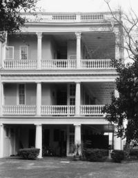
Description:
60 - 64 Broad Street, The Confederate Home, ca. 1800. Detail View of portico entry, South (Front) elevation. 4" x 5" B/W photo.
Date:
1977-1983
Description:
110 Broad Street, William Harvey House, ca. 1728. Main House - View of East (Side) elevation. 4" x 5" B/W photo.
Date:
1977-1983
Description:
Georgetown County, Mansfield Plantation, ca. 1780. Rice Threshing Mill - Interior View. Threshers, SE elevation. 4" x 5" B/W photo.
Date:
1977-1983
Description:
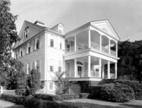
456 King Street, William Aiken House, ca. 1811. Whole Property - View of SW (Front and Side) elevation. 4" x 5" B/W photo.
Date:
1977-1983
Description:
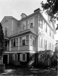
456 King Street, William Aiken House, ca. 1811. Whole Property - View of North (Side) elevation. 4" x 5" B/W photo.
Date:
1977-1983
Description:
Berkley County, Mulberry Plantation, ca. 1714. Copy of undated historic photo. View of SW (Front and Side) elevation. 4" x 5" B/W photo.
Date:
1977-1983
Description:
Georgetown County, Mansfield Plantation, ca. 1780. Rice Threshing Mill - Detail View of entrance. 4" x 5" B/W photo.
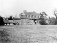
Date:
1977-1983
Description:
Georgetown County, Wicklow Hall Plantation, ca. 1825. Main House - View of South (Rear) elevation. 4" x 5" B/W photo.
Date:
1977-1983
Description:
92 Church Street, Alexander Christie House, ca. 1908. View of NW (Front and Side) elevation. Shows extent of dependencies. 4" x 5" B/W photo.
Date:
1977-1983
Description:
178 Ashley Avenue, Wickliffe House (John Hume Lucas House). Detail View of entry, West (Front) elevation. 4" x 5" B/W photo.
Date:
1977-1983
Description:
Charleston County (2695 Laurel Hill Road), Prospect Hill Plantation, ca. 1861. Detail View of portico and cornice elements. 4" x 5" B/W photo.
Date:
1977-1983
Description:
6 Glebe Street, St. Philip's Parsonage House (Bishop Robert Smith House), ca. 1770. Interior View. 1st and 2nd Floor - Hall, Detail of cornice. 4" x 5" B/W photo.
Date:
1977-1983
Description:
552 East Bay Street, Seaboard Airline RR Freight Station, date unknown. View of South (Front) elevation. 4" x 5" B/W photo.
Date:
1977-1983
Description:
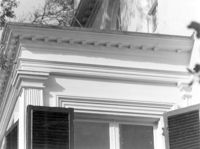
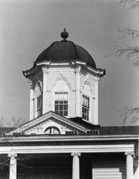
635 East Bay Street, Faber-Ward House, ca. 1832. Main House - Detail View of cupola and pediment, North (Side) elevation 4" x 5" B/W photo.
Date:
1977-1983
Description:
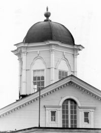
635 East Bay Street, Faber-Ward House, ca. 1832. Main House - Detail View of cupola and pediment, West (Rear) elevation 4" x 5" B/W photo.
Date:
1977-1983
Description:
71 Church Street, Col. Robert Brewton House, ca.1732. View of SE (Front and Side) elevation. 4" x 5" B/W photo.
Date:
1977-1983
Description:
60 Montague Street, Gaillard-Bennett House, ca. 1800. Main House, View of North (Rear) elevation. 4" x 5" B/W photo.
Date:
1977-1983
Description:
71 Church Street, Col. Robert Brewton House, ca.1732. Detail View of brick cornice. 4" x 5" B/W photo.
Date:
1977-1983
Description:
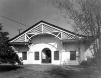
69 Church Street, Capers-Motte House, ca. 1745. View of Stable, East (Front) elevation. 4" x 5" B/W photo.
Date:
1977-1983
Description:
126 Coming Street, Cathedral Church of St. Luke and St. Paul, ca. 1816. Detail View of minor entry doors to balcony, West (Front) elevation. 4" x 5" B/W photo.
Date:
1977-1983
Description:
126 Coming Street, Cathedral Church of St. Luke and St. Paul, ca. 1816. Interior View - Altar apse, Detail of tablet niche and tabernacles. 4" x 5" B/W photo.
Date:
1977-1983
Description:
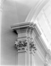
126 Coming Street, Cathedral Church of St. Luke and St. Paul, ca. 1816. Interior View - Altar apse, Detail of pilaster cap and cornice. 4" x 5" B/W photo.
Date:
1977-1983
Description:
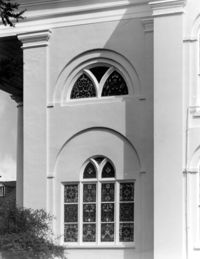
126 Coming Street, Cathedral Church of St. Luke and St. Paul, ca. 1816. Detail View of windows on tower base, South (Side) elevation. 4" x 5" B/W photo.
Date:
1977-1983
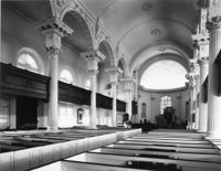
Description:
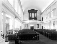
126 Coming Street, Cathedral Church of St. Luke and St. Paul, ca. 1816. Interior View - Nave, looking West. 4" x 5" B/W photo.
Date:
1977-1983
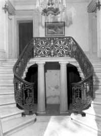
Description:
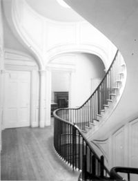
172 Rutledge Avenue, Ashley Hall, ca. 1802. Main House - Interior View. 2nd Floor - View of stairs, looking West. 4" x 5" B/W photo.
Date:
1977-1983
Description:
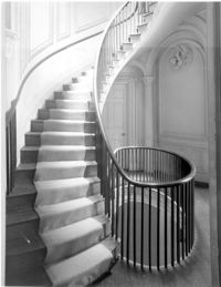
172 Rutledge Avenue, Ashley Hall, ca. 1802. Main House - Interior View. 1st Floor - View of stairs, looking East. 4" x 5" B/W photo.
Date:
1977-1983
Description:
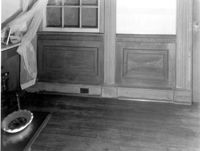
Berkley County, Lawson's Pond, ca. 1823. Interior View. 1st Floor - NW Room, North wall. Detail of faux finishing - wood grained wainscot, marbleized base, painted door and window architraves. 4" x 5" B/W photo.
Date:
1977-1983
Description:
110 Broad Street, William Harvey House, ca. 1728. Main House - View of South (Front) elevation. 4" x 5" B/W photo.
Date:
1977-1983
Description:
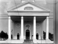
48 Hasell Street, St. Johannes Lutheran Church, ca. 1842. View of East (Front) elevation. 4" x 5" B/W photo.
Date:
1977-1983
Description:
2 Amherst Street, Christopher Belser House, ca. 1804. View of SW (Front and Side) elevation. 4" x 5" B/W photo.
Date:
1977-1983
Description:
Charleston County, Oak Island Plantation, ca. 1830. Interior View. 1st Floor - NE Room, Detail of cornice. 4" x 5" B/W photo.
Date:
1977-1983
Description:
Charleston County (2695 Laurel Hill Road), Prospect Hill Plantation, ca. 1861. View of East (Side) elevation. 4" x 5" B/W photo.
Date:
1977-1983
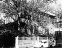
Description:
19 Archdale Street, Philip Porcher House, ca. 1765. View of SE (Front and Side) elevation. 4" x 5" B/W photo.
Date:
1977-1983
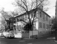
Description:
19 Archdale Street, Philip Porcher House, ca. 1765. View of NE (Front and Side) elevation. 4" x 5" B/W photo.
Date:
1977-1983
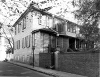
Description:
19 Archdale Street, Philip Porcher House, ca. 1765. View of NW (Rear and Side) elevation. 4" x 5" B/W photo.
Date:
1977-1983
Description:
Georgetown County, Wicklow Hall Plantation, ca. 1825. Barn - View of Front and Side elevation. 4" x 5" B/W photo.
Date:
1977-1983
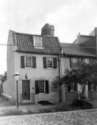
Description:
17 Chalmers Street, The Pink House, ca. 1712. View of North (Front) elevation. 4" x 5" B/W photo.
Date:
1977-1983
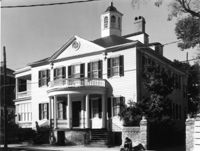
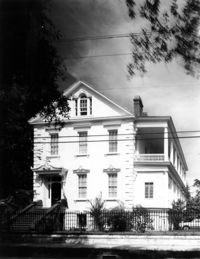
Description:
7 Meeting Street, Josiah Smith House, ca. 1783. View of NE (Front and Side) elevation. 4" x 5" B/W photo.
Date:
1977-1983
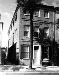
Description:
131 Church Street, James Huston House, ca. 1809. View of SE (Front and Side) elevation. 4" x 5" B/W photo.
Date:
1977-1983
Description:
8 Judith Street, John Robinson Tenements, ca. 1817. Kitchen House - View of NW (Side and Front) elevation. 4" x 5" B/W photo.
Date:
1977-1983
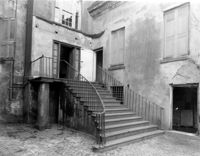
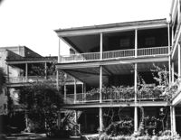
Description:
60 - 64 Broad Street, The Confederate Home, ca. 1800. View of courtyard, North elevation. 4" x 5" B/W photo.
Date:
1977-1983
Description:
60 - 64 Broad Street, The Confederate Home, ca. 1800. View of courtyard, SE elevation. 4" x 5" B/W photo.
Date:
1977-1983
Description:
192 Ashley Avenue, Wickenberg House, ca. 1859. View of West (Front) elevation. 4" x 5" B/W photo.
Date:
1977-1983
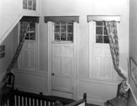
Description:
Orangeburg County, Rocks Plantation (The Rocks), ca. 1805. Main House - Interior View. 2nd Floor - Landing, North end of Hall. 4" x 5" B/W photo.
Date:
1977-1983
Description:
Charleston County, William Seabrook-Dodge Plantation, ca. 1810. Detail View of 2nd Floor cornice. 4" x 5" B/W photo.
Date:
1977-1983
Description:
60 Montague Street, Gaillard-Bennett House, ca. 1800. Kitchen House - View of NW (Front and Side) elevation. 4" x 5" B/W photo.
Date:
1977-1983
Description:
8 South Battery, Colonel William Washington House, ca. 1768. Main House - View of South (Front) elevation. 4" x 5" B/W photo.
Date:
1977-1983
Description:
60 Montague Street, Gaillard-Bennett House, ca. 1800. Kitchen House - View of East (Side) elevation. 4" x 5" B/W photo.
Date:
1977-1983
Description:
5 Queen Street, ca.1760. View of North elevation, looking West to East. 4" x 5" B/W photo.
Date:
1977-1983
Description:
5 Queen Street, ca.1760. View of North elevation, looking East to West. 4" x 5" B/W photo.
Date:
1977-1983
Description:
110 Broad Street, William Harvey House, ca. 1728. Kitchen Building - Interior View. 1st Floor - SE elevation, before stucco removal. 4" x 5" B/W photo.
Date:
1977-1983
Description:
110 Broad Street, William Harvey House, ca. 1728. Kitchen Building - Interior View. 1st Floor - SE elevation, after stucco removal. 4" x 5" B/W photo.
Date:
1977-1983
Description:
21 East Battery, Edmonston-Alston House, ca. 1828. Main House - View of West (Rear) elevation. 4" x 5" B/W photo.
Date:
1977-1983
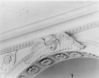
Description:
146 Church Street, St. Philip's Episcopal Church, ca. 1836. Interior View - Detail of arch cherub, long winged. 4" x 5" B/W photo.
Date:
1977-1983
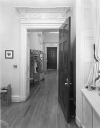
Description:
14 George Street, Middleton-Pinckney House, ca. 1796. Interior View - 2nd Floor. Detail of door, NE room to hall & NW room beyond hall. 4" x 5" B/W photo.
Date:
1977-1983
Description:
146 Church Street, St. Philip's Episcopal Church, ca. 1836. Interior View - altar, NE (Front and Side) elevation. 4" x 5" B/W photo.
Date:
1977-1983
Description:
14 George Street, Middleton-Pinckney House, ca. 1796. Interior View - 1st Floor. Center Room from stair hall, North elevation. 4" x 5" B/W photo.
Date:
1977-1983
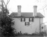
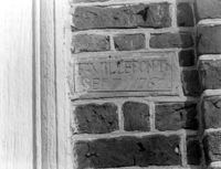
Description:
Berkeley County, St. Stephen's Church, ca. 1767. Detail View of plaque bearing architect/builder's name (F. Villepontoux), South (Side) elevation (located to right of door jamb). 4" x 5" B/W photo.
Date:
1977-1983
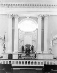
Description:
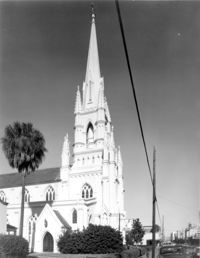
275 Meeting Street, Trinity Methodist Church, ca. 1848. Interior View - Detail of chancel and altar, East elevation. 4" x 5" B/W photo.