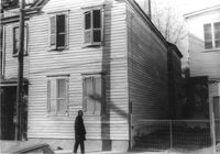
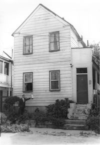
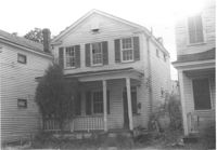
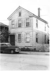
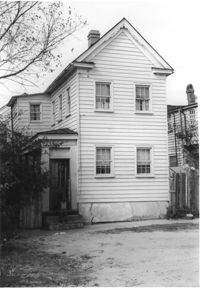
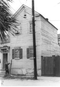
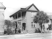
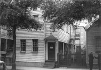
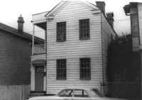
House on site affected by the construction of the Crosstown. Address: 160 Line Street. Surveyor notations on back of photo: "Dkt.: 10.524. Property owner: John Meyer, Est. Tract: 101. Station: 83+30 CL. Date: Dec. 1, 1964. In R/W - Bought." [See collection description for explanation of surveyor notations.]
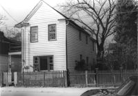
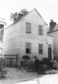
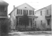
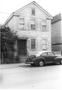
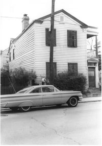
House on site affected by the construction of the Crosstown. Address: 162 Line Street. Surveyor notations on back of photo: "Dkt.: 10.524. Property owner: James Washington. Tract: 100. Station: 82+85 Lt. Date: Dec. 1, 1964. In R/W - Bought." [See collection description for explanation of surveyor notations.]
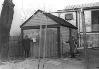
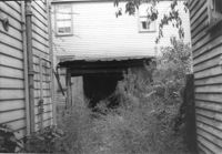
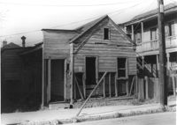
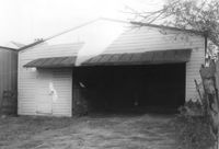
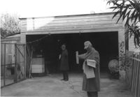
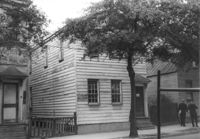
Storage shed or garage on site affected by the construction of the Crosstown. Address: 160 Line Street. Surveyor notations on back of photo: "Dkt.: 10.524. Property owner: John Meyer, Est. Tract: 101. Station: 83+25 Lt. Date: Dec. 1, 1964. In R/W - Bought." [See collection description for explanation of surveyor notations.]
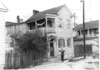
House on site affected by the construction of the Crosstown. Address: 147 President Street. Surveyor notations on back of photo: "Dkt.: 10.524. Property owner: Frank Chinners. Tract: 31. Station: 67+60 Rt. Date: Oct. 13, 1964. Partially In R/W - Bought." [See collection description for explanation of surveyor notations.]
House on site affected by the construction of the Crosstown. Address: 9 Presidents Place. Surveyor notations on back of photo: "Dkt.: 10.524. Property owner: Mary Robinson, Est. Tract: 8. Station: 63+40 Rt. Date: Oct. 13, 1964. In R/W - Bought." [See collection description for explanation of surveyor notations.]
House on site affected by the construction of the Crosstown. Address: 9 Presidents Place. Surveyor notations on back of photo: "Dkt.: 10.524. Property owner: Mary Robinson, Est. Tract: 8. Station: 63+40 Rt. Date: Oct. 13, 1964. In R/W - Bought." [See collection description for explanation of surveyor notations.]
House on site affected by the construction of the Crosstown. Address: 11 Presidents Place. Surveyor notations on back of photo: "Dkt.: 10.524. Property owner: Lucille Smalls. Tract: 9. Station: 63+10 Rt. Date: Oct. 13, 1964. In R/W - Bought." [See collection description for explanation of surveyor notations.]
Structure and lot on site affected by the construction of the Crosstown. Address: 160 Cannon Street. Surveyor notations on back of photo: "Dkt.: 10.524. Property owner: Mabel M. Cecil McIherney. Tract: 7. Station: 62+75 CL Lt. Date: Oct. 13, 1964. Portion In R/W - Bought." [See collection description for explanation of surveyor notations.]
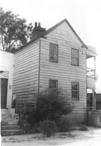
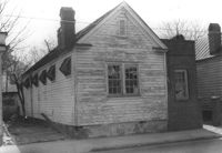
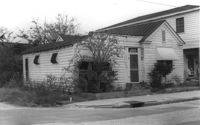
House on site affected by the construction of the Crosstown. Address: 161 Line Street. (Possibly a freedman's cottage with altered entry and porch.) Surveyor notations on back of photo: "Dkt.: 10.524. Property owner: Christopher C. Polite, Est. Tract; 94. Station: 81+90 CL. Date: Dec. 1, 1964. In R/W - Bought." [See collection description for explanation of surveyor notations.]
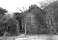
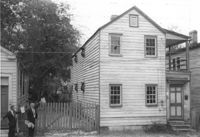
House (freedman's cottage) on site affected by the construction of the Crosstown. Address: 3 Rosemont Street. Surveyor notations on back of photo: "Dkt.: 10.524. Property owner: Christopher Ward. Tract: 54. Station: 71+70 Rt. Date: Oct. 14, 1964." [See collection description for explanation of surveyor notations.]
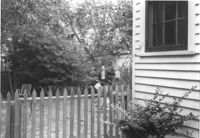
Rear view of house on site affected by the construction of the Crosstown. Address: 3 Rosemont Street. Wood fence in foreground. Surveyor notations on back of photo: "Dkt.: 10.524. Property owner: Christopher Ward. Tract: 54. Station: 71+70 Rt. Date: Oct. 14, 1964. Portion in R/W to be removed by property owner." [See collection description for explanation of surveyor notations.]
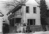
House on site affected by the construction of the Crosstown. Address: 159 President Street. Surveyor notations on back of photo: "Dkt.: 10.524. Property owner: James E. Campbell. Tract: 37. Station: 69+30 Lt. Date: Oct. 14, 1964. Partially in R/W." [See collection description for explanation of surveyor notations.]
House (corner view) on site affected by the construction of the Crosstown. Address: 120 Bogard Street. View of street corner. Surveyor notations on back of photo: "Dkt.: 10.524. Property owner: James Green. Tract: 59. Station: 79+25 Lt. Date: Oct. 14, 1964. In R/W - Bought." [See collection description for explanation of surveyor notations.]
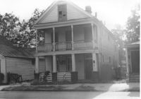
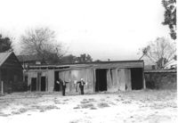
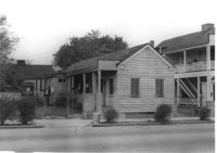
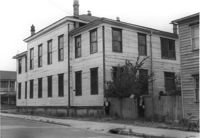
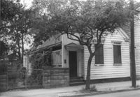
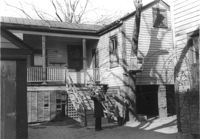
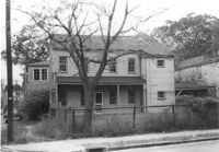
Houses on site affected by the construction of the Crosstown. Address: 113 Bogard Street (the original Dart Hall). Surveyor notations on back of photo: "Dkt.: 10.524. Property owner: Charleston County. Tract: 58. Station: 75+00 Rt. Date: Oct. 14, 1964. Loss of use of back area." [See collection description for explanation of surveyor notations.]
House on site affected by the construction of the Crosstown. Address: 159 President Street. Surveyor notations on back of photo: "Dkt.: 10.524. Property owner: James E. Campbell. Tract: 37. Station: 69+30 Lt. Date: Oct. 14, 1964. Partially in R/W." [See collection description for explanation of surveyor notations.]
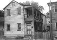
House on site affected by the construction of the Crosstown. Address: 161 President Street. Surveyor notations on back of photo: "Dkt.: 10.524. Property owner: James H. Rudolph. Tract: 37-A. Station: 69+50 Lt. Date: Oct. 14, 1964. Wall and gate In R/W - Bought." [See collection description for explanation of surveyor notations.]
House on site affected by the construction of the Crosstown. Address: 155 President Street. Surveyor notations on back of photo: "Dkt.: 10.524. Property owner: Walter C. Middleton, Est. Tract: 35. Station: 68+90 CL Lt. Date: Oct. 13, 1964. In R/W - Bought." [See collection description for explanation of surveyor notations.]
House on site affected by the construction of the Crosstown. Address: 155 President Street. Surveyor notations on back of photo: "Dkt.: 10.524. Property owner: Walter C. Middleton, Est. Tract: 35. Station: 68+90 CL Lt. Date: Oct. 13, 1964. In R/W - Bought." [See collection description for explanation of surveyor notations.]
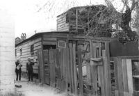
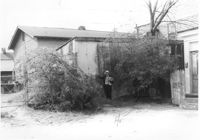
Shed in rear of house, on site affected by the construction of the Crosstown. Address: 11 Kennedy Street. Surveyor notations on back of photo: "Dkt.: 10.524. Property owner: J. Arthur Brown. Tract: 87. Station: 80+45 Rt. Date: Oct. 14, 1964. Behind house." [See collection description for explanation of surveyor notations.]
Rear view of house on site affected by the construction of the Crosstown. Address: 26½ Kracke Street [26 Kracke Street]. Surveyor notations on back of photo: "Dkt.: 10.524. Property owner: Julie Brown. Tract: 68. Station: 77+90 Lt. Date: Oct. 14, 1964. In R/W - Bought." [See collection description for explanation of surveyor notations.]
House on site affected by the construction of the Crosstown. Address: 263 Ashley Avenue. Surveyor notations on back of photo: "Dkt.: 10.524. Property owner: Zion Presbyterian Church. Tract: 79. Station: 78+50 CL Rt. Date: Oct. 14, 1964. In R/W - Bought." [See collection description for explanation of surveyor notations.]
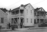
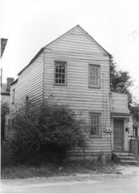
House on site affected by the construction of the Crosstown. Address: 183 Spring Street. Surveyor notations on back of photo: "Dkt.: 10.524. Property owner: Minnie Waites, et al. Tract: 16-A. Station: 64+50 CL. Date: Oct. 13, 1964. In R/W - Bought." [See collection description for explanation of surveyor notations.]
House in dilapidated condition (freedman's cottage) on site affected by the construction of the Crosstown. Address: 5 Todd Street. Surveyor notations on back of photo: "Dkt.: 10.524. Property owner: Urban M. Kennedy, Est. Tract: 119. Station: 87+45 CL. Date:: Dec. 2, 1964. In R/W - Bought." [See collection description for explanation of surveyor notations.]
House on site affected by the construction of the Crosstown. Address: 183 Spring Street. Surveyor notations on back of photo: "Dkt.: 10.524. Property owner: Minnie Waites, et al. Tract: 16-A. Station: 64+50 CL. Date: Oct. 13, 1964. In R/W - Bought." [See collection description for explanation of surveyor notations.]
House on site affected by the construction of the Crosstown. Address: 12 Presidents Place. Surveyor notations on back of photo: "Dkt.: 10.524. Property owner: Dewitt W. King. Tract: 16. Station: 64+00 Rt. Date: Oct. 13, 1964. In R/W - Bought." [See collection description for explanation of surveyor notations.]
House on site affected by the construction of the Crosstown. Address: 12 Presidents Place. Surveyor notations on back of photo: "Dkt.: 10.524. Property owner: Dewitt W. King. Tract: 16. Station: 64+00 Rt. Date: Oct. 13, 1964. In R/W - Bought." [See collection description for explanation of surveyor notations.]
Structure (rear view) on site affected by the construction of the Crosstown. Address: 185 Spring Street. Surveyor notations on back of photo: "Dkt.: 10.524. Property owner: Star Gospel Mission. Tract: 15. Station: 24+50 Rt. (Spring Street). Date: Oct. 13, 1964. Portion in R/W to be removed." [See collection description for explanation of surveyor notations.]
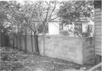
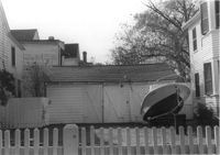
Backyard and cinder block wall on site affected by the construction of the Crosstown. Address: 180 Spring Street. Surveyor notations on back of photo: "Dkt.: 10.524. Property owner: Edward Keith. Tract: 29. Station: 66+95 Rt. Date: Oct. 13, 1964. Portion In R/W - Bought." [See collection description for explanation of surveyor notations.]
House on site affected by the construction of the Crosstown. Address: 10 Presidents Place. Surveyor notations on back of photo: "Dkt.: 10.524. Property owner: Cecelia Elizabeth Cook, Est. Tract: 17. Station: 64+50 Rt. Date: Oct. 13, 1964. Partially In R/W - Bought." [See collection description for explanation of surveyor notations.]
House on site affected by the construction of the Crosstown. Address: 10 Presidents Place. Surveyor notations on back of photo: "Dkt.: 10.524. Property owner: Cecelia Elizabeth Cook, Est. Tract: 17. Station: 64+50 Rt. Date: Oct. 13, 1964. Partially In R/W - Bought." [See collection description for explanation of surveyor notations.]
House on site affected by the construction of the Crosstown. Address: 181 Spring Street. Surveyor notations on back of photo: "Dkt.: 10.524. Property owner: Cecelia Elizabeth Cook, Est. Tract: 17. Station: 64+10 Rt. Date: Oct. 13, 1964. Partially In R/W - Bought." [See collection description for explanation of surveyor notations.]
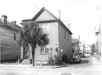
House (freedman's cottage) on site affected by the construction of the Crosstown. Address: 261 Ashley Avenue. Surveyor notations on back of photo: "Dkt.: 10.524. Property owner: Frank H. McGill, Estate. Tract: 77. Station: 78+40 Rt. Date: Oct. 14, 1964. In R/W - Bought." [See collection description for explanation of surveyor notations.]
Garage on site affected by the construction of the Crosstown. Address: 508 Rutledge Avenue. Surveyor notations on back of photo: "Dkt.: 10.524. Property owner: W.C. Hayes, Est. Tract: 112. Station: 87±00. Date: Dec. 1, 1964. In R/W - Bought." [See collection description for explanation of surveyor notations.]
Garage on site affected by the construction of the Crosstown. Address: 510 Rutledge Avenue. Surveyor notations on back of photo: "Dkt.: 10.524. Property owner: George J. Carabates. Tract: 111. Station: 87±05 Lt. Date: Dec. 1, 1964." [See collection description for explanation of surveyor notations.]
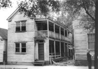
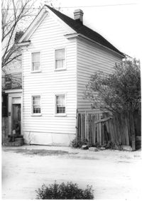
House (rear view) on site affected by the construction of the Crosstown. Address: 160½ Line Street [160 Line Street]. Surveyor notations on back of photo: "Dkt.: 10.524. Property owner: John Meyer, Est. Tract: 101. Station: 83+65 Lt. Date: Dec. 1, 1964. In R/W - Bought." [See collection description for explanation of surveyor notations.]
House on site affected by the construction of the Crosstown. Address: 15 Kennedy Street. Surveyor notations on back of photo: "Dkt.: 10.524. Property owner: J. Arthur Brown. Tract: 84. Station: 80+15 CL Rt. Date: Oct. 14, 1964. In R/W - Bought." [See collection description for explanation of surveyor notations.]
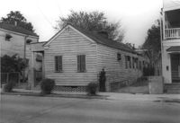
House (corner view) on Cannon Street, on site affected by the construction of the Crosstown. Address: 162A Cannon Street (address on 1951 Sanborn Map). View of street corner (northwest corner of Cannon Street and Wescott Street). Surveyor notations on back of photo: "Dkt.: 10.524. Property owner: August Schilling. Tract: 3. Station: 60+50 Lt. Date: Oct. 13, 1964. Partially in R/W." [See collection description for explanation of surveyor notations.]
House on Cannon Street, on site affected by the construction of the Crosstown. Address: 162A Cannon Street (address on 1951 Sanborn Map, northwest corner Cannon and Wescott). Surveyor notations on back of photo: "Dkt.: 10.524. Property owner: August Schilling. Tract: 3. Station: 60+50 Lt. Date: Oct. 13, 1964. Partially in R/W." [See collection description for explanation of surveyor notations.]
House on site affected by the construction of the Crosstown. Address: 11 Kennedy Street. Surveyor notations on back of photo: "Dkt.: 10.524. Property owner: J. Arthur Brown. Tract: 87. Station: 80+65 Rt. Date: Oct. 14, 1964. In R/W - Bought." [See collection description for explanation of surveyor notations.]
House on site affected by the construction of the Crosstown. Address: 11 Kennedy Street. Surveyor notations on back of photo: "Dkt.: 10.524. Property owner: J. Arthur Brown. Tract: 87. Station: 80+65 Rt. Date: Oct. 14, 1964. In R/W - Bought." [See collection description for explanation of surveyor notations.]
House (rear view) on site affected by the construction of the Crosstown. Address: 6 Kennedy Street. Surveyor notations on back of photo: "Dkt.: 10.524. Property owner: Eugene Whitney. Tract: 89. Station: 81+80 Rt. Date: Oct. 14, 1964." [See collection description for explanation of surveyor notations.]
House on site affected by the construction of the Crosstown. Address: 162 Line Street. Surveyor notations on back of photo: "Dkt.: 10.524. Property owner: James Washington. Tract: 100. Station: 82+85 Lt. Date: Dec. 1, 1964. In R/W - Bought." [See collection description for explanation of surveyor notations.]
House on site affected by the construction of the Crosstown. Address: 267 Ashley Avenue. "No Trespassing" sign posted on door. Surveyor notations on back of photo: "Dkt.: 10.524. Property owner: Arthur Murrell, et al. Tract: 81. Station: 79+00 Lt. Date: Oct. 14, 1964. In R/W - Bought." [See collection description for explanation of surveyor notations.]
House on site affected by the construction of the Crosstown. Address: 267 Ashley Avenue. "No Trespassing" sign posted on door. Surveyor notations on back of photo: "Dkt.: 10.524. Property owner: Arthur Murrell, et al. Tract: 81. Station: 79+00 Lt. Date: Oct. 14, 1964. In R/W - Bought." [See collection description for explanation of surveyor notations.]
House (side view) on site affected by the construction of the Crosstown. Address: 15 Kennedy Street. House is on corner lot; view of street corner. Surveyor notations on back of photo: "Dkt.: 10.524. Property owner: J. Arthur Brown. Tract: 84. Station: 80+15 CL Rt. Date: Oct. 14, 1964. In R/W - Bought." [See collection description for explanation of surveyor notations.]
Rear portion of house and backyard, on site affected by the construction of the Crosstown. Address: 257 Ashley Avenue. Surveyor notations on back of photo: "Dkt.: 10.524. Property owner: Daisey DeCosta Caffry. Tract: 75. Station: 77+95 Rt. Date: Oct. 14, 1964. Proximity." [See collection description for explanation of surveyor notations.]
House on site affected by the construction of the Crosstown. Address: 114 Bogard Street. Surveyor notations on back of photo: "Dkt.: 10.524. Property owner: Francis Jenkins, et al. Tract: 64. Station: 75+70 CL Rt. Date: Oct. 14, 1964. In R/W - Bought." [See collection description for explanation of surveyor notations.]
Shed and/or garage and yard on site affected by the construction of the Crosstown. Address: 285 Coming Street. Surveyor notations on back of photo: "Dkt.: 10.524. Property owner: Gladys S. Wilson. Tract: 151. Station: 21+00 Rt. S.B. lane. Date: Dec. 2, 1964. In R/W - Bought." [See collection description for explanation of surveyor notations.]
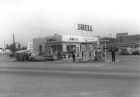
Shell gas station, on site affected by the construction of the Crosstown. Address: 233 Spring Street. Surveyor notations on back of photo: "Dkt.: 10.524. Property owner: Shell Oil Co. Tract: 155. Station: 9+20 Rt. Spring Street. Date: Dec. 2, 1965." [See collection description for explanation of surveyor notations.]
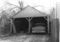
Garage and portion of driveway on site affected by the construction of the Crosstown. Address: 99 Fishburne Street. Surveyor notations on back of photo: "Dkt.: 10.524. Property owner: Richard Wright, et al. Tract: 153. Station: 20+80 Lt. S.B. lane. Date: Dec. 2, 1964." [See collection description for explanation of surveyor notations.]