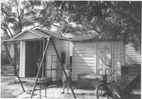
Two sheds and swing set, with standing girl, on site affected by the construction of Interstate 26 (I-26). Address: 2124 Weaver Avenue. Surveyor notations on back of photo: "Dkt.: 10.490. Property owner: Harry L. Rumph, Jr. Tract: 188. Station: 30' Lt. Sta. 5886-55. Date: May 15, 1962. In R/W - Bought." [See collection description for explanation of surveyor notations.]
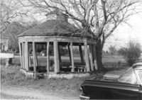
Gazebo, on site affected by the widening of Route 171 (Folly Road). Surveyor notations on back of photo: "Dkt.: 10.494. Property owner: Sophie Sabel, Est. Tract: 97. Station: 370+50 Lt. Date: Mar. 21, 1962. In R/W - Bought. [See collection description for explanation of surveyor notations.]
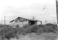
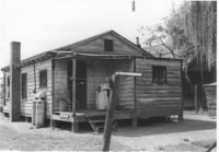
Dilapidated wood-sided structure on site affected by the construction of Interstate 26 (I-26). On grounds with many power lines on property. On Meeting Street/Meeting Street Road Surveyor notations on back of photo: "Dkt.: 10.510. Property owner: Geo. Fabian, Jr. Tract: 67. Station: 5796+10 on CL Lt. (Meeting Street). Date: Sept. 12, 1962. In R/W - Bought." [See collection description for explanation of surveyor notations.]
House on or in vicinity of King Street Extn., on site affected by the construction of Interstate 26 (I-26). Surveyor notations on back of photo: "Dkt.: 10.490. Property owner: V.C. Chemical Co. Tract: 1. Station: 5808+00 Lt. (Line F). Date: September 11, 1962. Partially in R/W." [See collection description for explanation of surveyor notations.]
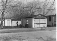
Garage and shed on site affected by the construction of Interstate 26 (I-26). Surveyor notations on back of photo: "Dkt.: 10.490. Property owner: Mostester Brown [Mostester Brown?]. Tract: 87-C. Station: 5825+45 Rt. Date: March 22, 1962. In R/W - Bought." [See collection description for explanation of surveyor notations.]
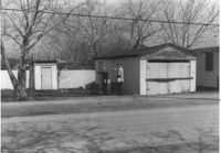
Garage and shed on site affected by the construction of Interstate 26 (I-26). Surveyor notations on back of photo: "Dkt.: 10.490. Property owner: Mostester Brown [Montester Brown?]. Tract: 87-C. Station: 5825+45 Rt. [Undated.] In R/W - Bought." [See collection description for explanation of surveyor notations.]
House on site affected by the construction of Interstate 26 (I-26). Building address number 208. Surveyor notations on back of photo: "Dkt.: 10.490. Property owner: Cora L. Gantt, et al. Tract: 65. Station: 5802+90 Lt. Line 'F'. Date: September 12, 1962. In R/W - Bought." [See collection description for explanation of surveyor notations.]
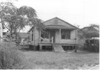
House (rear view) on site affected by the construction of Interstate 26 (I-26). Surveyor notations on back of photo: "Dkt.: 10.490. Property owner: E.S. Lapine, et al. Tract: 60. Station: 5801+40 Rt. Line 'G'. Date: September 12, 1962. In R/W - Bought." [See collection description for explanation of surveyor notations.]
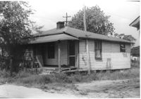
House (rear view) on site affected by the construction of Interstate 26 (I-26). Surveyor notations on back of photo: "Dkt.: 10.490. Property owner: Leah D. Governor. Tract: 58. Station: 5800+70 Lt. Line 'G'. Date: September 12, 1962. In R/W - Bought." [See collection description for explanation of surveyor notations.]