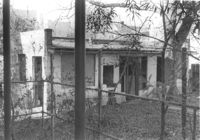
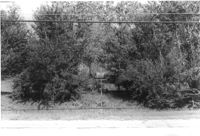
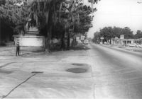
Structure on site affected by the construction of the Crosstown. Address: 122 Sheppard Street. Surveyor notations on back of photo: "Dkt.: 10.524. Property owner: Archie B. Hollins. Tract: 136. Station: 17+40 Lt. S.B. lane. Date: Dec. 2, 1964. Outside R/W." [See collection description for explanation of surveyor notations.]
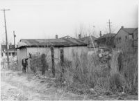
Wooden structure (shed or garage?) (rear view) on site affected by the construction of Interstate 26 (I-26). Address: 23 Jacobs Court. Surveyor notations on back of photo: "Dkt.: 10.517. Property owner: Furman G. Owens. Tract: 60-B. Station: 40+00 Lt. Northbound Lane, 5960+40 Lt. - Line 6. Date: March 5, 1963. In R/W - Bought." [See collection description for explanation of surveyor notations.]
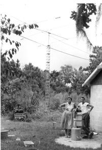
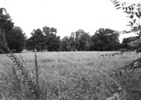
Lot with tall mast, on site affected by the construction of Interstate 26 (I-26). Surveyor notations on back of photo: "Dkt.: 10.471. Property owner: W.W. Gregory. Tract: 46. Station: 5330+00 Rt. Date: Aug. 23, 1960. Owner to move mast." [See collection description for explanation of surveyor notations.]
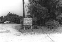
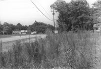
Lot on site affected by the widening of U.S. Route 17. Posted sign says: You just passed last motel for 50 miles, Mt. Pleasant Motel, ¼ mile back. Presumably located in Mount Pleasant or vicinity. Surveyor notations on back of photo: "Dkt.: 10.439. Property owner: Charleston County Public Works. Tract: 12. Station: 239+45 to 243+73 Rt. Date: Jul. 22, 1965. Range poles on 50' R/W & fence on 33' R/W - Cond." [See collection description for explanation of surveyor notations.]
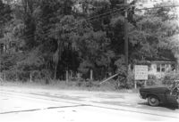
Lot on site affected by the widening of U.S. Route 17. Posted sign says: Speed checked by radar. Presumably located in Mount Pleasant or vicinity. Surveyor notations on back of photo: "Dkt.: 10.439. Property owner: Francis F. Coleman, et al. Tract: 13. Station: 245+50 Rt. Date: Jul. 22, 1965. Range poles on 33' & 50' R/W showing house (portion)." [See collection description for explanation of surveyor notations.]
Lot on site affected by the widening of U.S. Route 17. Presumably located in Mount Pleasant or vicinity. Surveyor notations on back of photo: "Dkt.: 10.439. Property owner: Charleston County Public Works. Tract: 12. Station: 239+45 to 243+73 Rt. Date: Jul. 22, 1965. Looking from the east at range poles on 50' R/W & fence on 33' R/W - Cond." [See collection description for explanation of surveyor notations.]
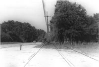
Lot on site affected by the widening of U.S. Route 17. Presumably located in Mount Pleasant or vicinity. Surveyor notations on back of photo: "Dkt.: 10.439. Property owner: Charleston Oil Co. Tract: 11. Station: 237+26 to 239+45 Rt. Date: Jul. 22, 1965. Range poles on 33' & 50' R/W - Cond." [See collection description for explanation of surveyor notations.]
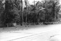
Site affected by the widening of Route 171 (Folly Road). Folly Road Pantry, B&H Grocery, and Phillips 66 gas Station: in background. Surveyor notations on back of photo: "Dkt.: 10.494. Property owner: H.W. Halter, et al. Tract: 78. Station: 298+44 Rt. Date: Mar. 21, 1962. Loss in R/W. [See collection description for explanation of surveyor notations.]
Lot on site affected by the widening of U.S. Route 17. Posted sign says: You just passed last motel for 50 miles, Mt. Pleasant Motel, ¼ mile back. Portion of house visible. Presumably located in Mount Pleasant or vicinity. Surveyor notations on back of photo: "Dkt.: 10.439. Property owner: Charleston County Public Works. Tract: 12. Station: 240+00 Rt. Date: Jul. 22, 1965. Looking from west at range poles on 50' R/W & fence on 33' R/W - Cond." [See collection description for explanation of surveyor notations.]
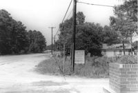
Roadside lot on site affected by the widening of U.S. Route 17. Presumably located in Mount Pleasant or vicinity. Surveyor notations on back of photo: "Dkt.: 10.439. Property owner: Louise S. Carter. Tract: 3. Station: 230±50 Rt. Date: Jul. 22, 1965. Looking NE from Carter Ave. at range poles on 33' & 50' R/Ws - Cond." [See collection description for explanation of surveyor notations.]
Roadside lot on site affected by the widening of U.S. Route 17. Presumably located in Mount Pleasant or vicinity. Surveyor notations on back of photo: "Dkt.: 10.439. Property owner: Louise S. Carter. Tract: 3. Station: 229±50 Rt. Date: Jul. 22, 1965. Looking NE at range on 33' R/W & 50' R/W - Cond." [See collection description for explanation of surveyor notations.]
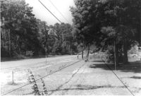
Lot on site affected by the widening of U.S. Route 17. Presumably located in Mount Pleasant or vicinity. Surveyor notations on back of photo: "Dkt.: 10.439. Property owner: Samuel D. Causey. Tract: 6. Station: 233±00 Rt. Date: Jul. 22, 1965. Range poles on 33' & 50' R/W - Cond." [See collection description for explanation of surveyor notations.]
Site affected by the widening of State Road 13 (Remount Road). Surveyor notations on back of photo: "Dkt.: 10.562. Property owner: Barbara Pringle. Tract: 43. Date: Jul. 19, 1967." [See collection description for explanation of surveyor notations.]
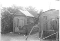
Structure (shed?) in dilapidated condition and wooden fence on site affected by the construction of Interstate 26 (I-26). Surveyor notations on back of photo: "Dkt.: 10.490. Property owner: Nathaniel Phoenix. Tract: 46. Station: 5799+60 Lt. Line 'G'. Date: September 11, 1962. In R/W - Bought." [See collection description for explanation of surveyor notations.]
Property and structure (shed?) on Dorchester Road, on site affected by the construction of Interstate 26 (I-26). Surveyor notations on back of photo: "Dkt.: 10.480. Property owner: Mrs. Dorothy V. Bartee. Tract: 178. Station: 132+42 Rt. (Route 642) [Dorchester Road]. Date: May 30, 1961. In R/W - Bought." [See collection description for explanation of surveyor notations.]
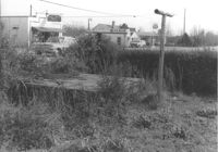
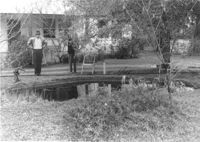
Pool and pump, on site affected by the widening of Route 171 (Folly Road). Surveyor notations on back of photo: "Dkt.: 10.494. Property owner: H.P. Duke. Tract: 51. Station: 186+65 Rt. Date: Mar. 21, 1962. Loss of pool and pump. [See collection description for explanation of surveyor notations.]
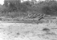
Pile of wood framing on lot, on site affected by the construction of Interstate 26 (I-26). Surveyor notations on back of photo: "Dkt.: 10.480. Property owner: Williams Furniture Co., et al. Tract: 103-B. Station: 5583+55 Rt. Date: May 2, 1961. In R/W - Bought." [See collection description for explanation of surveyor notations.]
Lot on site affected by the widening of U.S. Route 17. Presumably located in southern Charleston County. Surveyor notations on back of photo: "Dkt.: 10.600. Property owner: John D. Postell, Sr., Estate. Tract: 12. Station: 605± Rt. Date: Sept. 18, 1968." [See collection description for explanation of surveyor notations.]
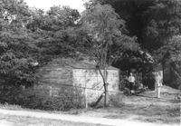
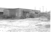
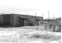
Structure on site affected by the construction of Interstate 26 (I-26). Surveyor notations on back of photo: "Dkt.: 10.490. Property owner: Ashley River Realty Co. Tract: 142. Station: 5876+60 Lt. Date: August 29, 1962. In R/W - Bought." [See collection description for explanation of surveyor notations.]
Structure on site affected by the construction of Interstate 26 (I-26). Surveyor notations on back of photo: "Dkt.: 10.490. Property owner: Ashley River Realty Co. Tract: 142. Station: 5876+60 Lt. Date: August 29, 1962. In R/W - Bought." [See collection description for explanation of surveyor notations.]
Limit your search
SCDOT Photographs: Properties in the Right-of-Way✖[remove]88