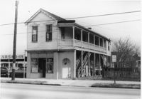
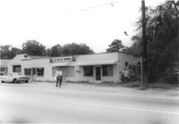
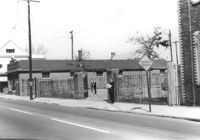
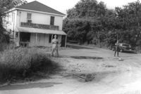
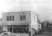
Infinger's Shoe Service on site affected by the construction of Interstate 26 (I-26). Address: 508 Meeting Street. Surveyor notations on back of photo: "Dkt.: 10.517. Property owner: Pandora Co. Tract: 63. Station: 5963+00 CL - Line 6. Date: March 5, 1963. Partially in R/W." [See collection description for explanation of surveyor notations.]
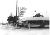
Marine Center (boat sales) on site affected by the construction of Interstate 26 (I-26). Address 4752 Rivers Avenue. View of street corner. C & R Motors in background. Possibly on Rivers Avenue. Surveyor notations on back of photo: "Dkt.: 10.486. Property owner: C.W. Keller. Tract: 33. Station: 2+75 Lt. (Line E). Date: May 30, 1961. Sign to be moved." [See collection description for explanation of surveyor notations.]
Building on site affected by the widening of U.S. Route 17. Front facade has stepped parapet. Appears to have previously been a business. Presumably located in Mount Pleasant or vicinity. Surveyor notations on back of photo: "Dkt.: 10.597. Property owner: Leon Burns, et al. Tract: 5. Station: 265± Lt. looking south. Date: Sept. 17, 1968." [See collection description for explanation of surveyor notations.]
Building, on site affected by the widening of Route 171 (Folly Road). Dave Richardson and Son General Contractor. Front facade has stepped parapet. Surveyor notations on back of photo: "Dkt.: 10.494. Property owner: Dave Richardson, et al. Tract: 93. Station: 314+40 Lt. Date: Mar. 21, 1962. To be cut off at R/W by SCHD [SC Highway Department?]. [See collection description for explanation of surveyor notations.]
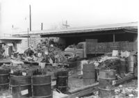
Commercial or industrial building (rear view) on site affected by the construction of Interstate 26 (I-26). Address: 71 Sheppard Street. Trash, scraps, and oil drums in foreground. Surveyor notations on back of photo: "Dkt.: 10.517. Property owner: Alex Goldberg, et al. Tract: 76. Station: 30+45 CL - Northbound Lane. Date: March 5, 1963. All in R/W." [See collection description for explanation of surveyor notations.]
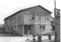
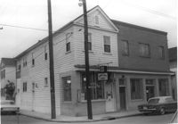
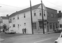
Building on site affected by the construction of Interstate 26 (I-26). View of street corner. Appears to previously have been a corner store named "Upper 10," perhaps with residence on second floor. Surveyor notations on back of photo: "Dkt.: 10.490. Property owner: Robert Martin. Tract: 38. Station: 5957+45 on CL Line 'G'. Date: September 11, 1962. In R/W - Bought." [See collection description for explanation of surveyor notations.]
Paul's Seat Covers (industrial-type building) on site affected by the construction of Interstate 26 (I-26). Address: 92 Cooper Street. (Appears to be to the right of house in previous photos.) Surveyor notations on back of photo: "Dkt.: 10.517. Property owner: Abe Goldberg. Tract: 66. Station: 5958+20 Lt. - Lane 4. Date: March 5, 1963. In R/W - Bought." [See collection description for explanation of surveyor notations.]
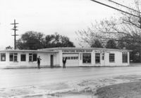
Furniture Repair Shop, on site affected by the widening of Route 171 (Folly Road). Surveyor notations on back of photo: "Dkt.: 10.494. Property owner: Isadora Bischoff. Tract: 32. Station: 162+00 Lt. Date: Mar. 21, 1962. Owner to cut off at R/W. [See collection description for explanation of surveyor notations.]
Building on site affected by the widening of U.S. Route 17. Appears to have previously been a store. Presumably located in Mount Pleasant or vicinity. Surveyor notations on back of photo: "Dkt.: 10.597. Property owner: Geo. G. Browder, Jr. Tract: 22. Station: 275+20 Lt. Date: Sept. 17, 1968." [See collection description for explanation of surveyor notations.]
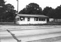
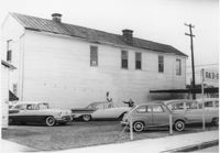
Buildings on site affected by the widening of U.S. Route 17. Wagon Wheel Furniture in foreground. Presumably located in Mount Pleasant or vicinity. Surveyor notations on back of photo: "Dkt.: 10.597. Property owner: Erma B. Salvo. Tract: 18. Station: 268± Lt. Date: Sept. 17, 1968." [See collection description for explanation of surveyor notations.]
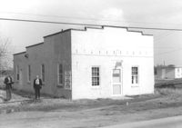
Building (rear view), perhaps once used commercially (market?), on site affected by the construction of Interstate 26 (I-26). Side facade has stepped parapet. [Building address number 2212(?).] Surveyor notations on back of photo: "Dkt.: 10.490. Property owner: F.F. Bellinger. Tract: 88. Station: 5825+40 Rt. Date: March 22, 1962. In R/W - Bought." [See collection description for explanation of surveyor notations.]
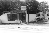
DuMont Television / Patterson's TV & Appliance Service Center / Karts Sales & Service on Dorchester Road, on site affected by the construction of Interstate 26 (I-26). Surveyor notations on back of photo: "Dkt.: 10.480. Property owner: Mrs. Margaret H. Patterson. Tract: 181. Station: 134+15 (Rt. (Route 642) [Dorchester Road]. Date: May 31, 1961. In R/W - Bought." [See collection description for explanation of surveyor notations.]
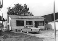
Pick & Pay Bicycle Repair Shop on site affected by the construction of Interstate 26 (I-26). Surveyor notations on back of photo: "Dkt.: 10.480. Property owner: G.S. Carter, Sr. Tract: 166. Station: 5681+50 Lt. Date: May 30, 1961. In R/W - Bought." [See collection description for explanation of surveyor notations.]
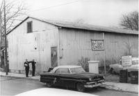
Health Club building and lot, on site affected by the construction of Interstate 26 (I-26). Nilson Storage Warehouse in background. Surveyor notations on back of photo: "Dkt.: 10.480. Property owner: G.S. Carter, Sr. Tract: 162. Station: 5677+60 Rt. Date: May 30, 1961. Damaged." [See collection description for explanation of surveyor notations.]
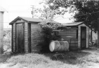
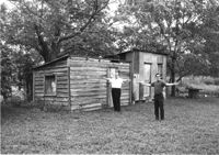
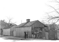
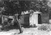
Sheds on site affected by the construction of Interstate 26 (I-26). Surveyor notations on back of photo: "Dkt.: 10.480. Property owner: Arlene Phillips, Est. Tract: 165. Station: 5681+10 Lt. Date: May 30, 1961. In R/W - Bought." [See collection description for explanation of surveyor notations.]
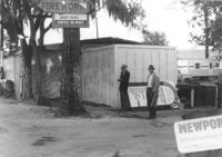
10-Mile News, on site affected by the widening of State Road 13 (Remount Road). Trailer park in background. Surveyor notations on back of photo: "Dkt.: 10.562. Property owner: Edna M. Tant. Tract: 5. Date: Jul. 12, 1967." [See collection description for explanation of surveyor notations.]
Buildings and lot on site affected by the construction of the Crosstown. Address: 620 King Street. Surveyor notations on back of photo: "Dkt.: 10.518. Property owner: News & Courier. Tract: 15. Station: 8+00 Lt. Line Street (Line #2) to 9+00 Lt. Date: Mar. 6, 1963. [Zero] Fence. [See collection description for explanation of surveyor notations.]
Sheds on site affected by the widening of U.S. Route 17. Presumably located in Mount Pleasant or vicinity. Surveyor notations on back of photo: "Dkt.: 10.597. Property owner: F. Gregorie, Estate. Tract: 93. Station: 460± Rt. Date: Sept. 17, 1968." [See collection description for explanation of surveyor notations.]
Sheds on site affected by the construction of Interstate 26 (I-26). Address: 1334 Rutledge Avenue. Surveyor notations on back of photo: "Dkt.: 10.490. Property owner: Heyward Barnes. Tract: 168. Station: 85' Rt. Sta. 5882+90. Date: May 15, 1962. In R/W - Bought." [See collection description for explanation of surveyor notations.]
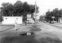
Lot next to McBride TV and Roy's Barber Shop, on site affected by the widening of State Road 13 (Remount Road). Atlantic gas Station: across the street. Surveyor notations on back of photo: "Dkt.: 10.562. Property owner: Pearl T. Leiderman. Tract: 40. Date: Jul. 19, 1967." [See collection description for explanation of surveyor notations.]
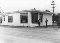
U-Nita-Do-It Yourself Store, on site affected by the widening of State Road 13 (Remount Road). Surveyor notations on back of photo: "Dkt.: 10.562. Property owner: John D. Stratos. Tract: 90. Date: Jul. 19, 1967." [See collection description for explanation of surveyor notations.]
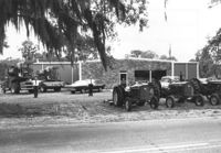
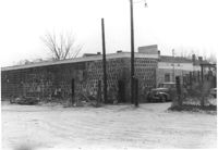
Building on site affected by the widening of U.S. Route 17. Tractors and other machinery on lot. Appears to be a dealer of equipment. Presumably located in southern Charleston County. Surveyor notations on back of photo: "Dkt.: 10.600. Property owner: Arthur J. Stark. Tract: 1. Station: 515± - 520± Lt. Date: Sept. 18, 1968." [See collection description for explanation of surveyor notations.]
Furniture Repair Shop, on site affected by the widening of Route 171 (Folly Road). Surveyor notations on back of photo: "Dkt.: 10.494. Property owner: Isadora Bischoff. Tract: 32. Station: 162+00 Lt. Date: Mar. 21, 1962. Owner to cut off at R/W. [See collection description for explanation of surveyor notations.]
McFadden Open Air Market, on site affected by the widening of Route 171 (Folly Road). Surveyor notations on back of photo: "Dkt.: 10.494. Property owner: Margaret H. Heirs. Tract: 44. Station: 175+50 Lt. Date: Mar. 21, 1962. Proximity. [See collection description for explanation of surveyor notations.]
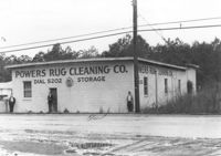
Powers Rug Cleaning Co, on site affected by the widening of Route 171 (Folly Road). Surveyor notations on back of photo: "Dkt.: 10.494. Property owner: K. & Dorothy Ohlinge. Tract: 38. Station: 174+30 Rt. Date: Mar. 21, 1962. Proximity. [See collection description for explanation of surveyor notations.]
Sheds or garages on site affected by the construction of the Crosstown. Address: corner of Lanier Court and Hanover Street. Surveyor notations on back of photo: "Dkt.: 10.518. Property owner: Bessie Rosen. Tract: 41. Station: 44+40 Rt. N.B. lane Route 17. Date: Mar. 6, 1963." [See collection description for explanation of surveyor notations.]
Building (Infinger's Shoe Service) (side view) on site affected by the construction of Interstate 26 (I-26). Address: 508 Meeting Street. Parking area in foreground. Surveyor notations on back of photo: "Dkt.: 10.517. Property owner: Pandora Co. Tract: 63. Station: 5963+00 CL - Line 6. Date: March 5, 1963. Partially in R/W. Men [in photo] In R/W." [See collection description for explanation of surveyor notations.]
Commercial or industrial building on site affected by the construction of Interstate 26 (I-26). Address: 71 Sheppard Street. Surveyor notations on back of photo: "Dkt.: 10.517. Property owner: Alex Goldberg, et al. Tract: 76. Station: 30+45 CL - Northbound Lane. Date: March 5, 1963. All in R/W." [See collection description for explanation of surveyor notations.]
Commercial building, appears to be vacant, next door to Gibson Tire Service, on site affected by the construction of Interstate 26 (I-26). Address: 85 Lee Street. Corner of Lee Street and Meeting Street. Sign: Thrift time-Values-Savings-Storewide Bargains in background. Surveyor notations on back of photo: "Dkt.: 10.517. Property owner: Thomas P. Gibson. Tract: 59. Station: 36±00 - 37±00 Rt. & Lt. Route 17. Date: February 21, 1963. All in R/W." [See collection description for explanation of surveyor notations.]
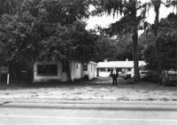
Building (corner view), on site affected by the construction of the Crosstown. Address: 207 Spring Street. Sew-U-Save Shop. View of street corner (corner of Spring Street and Courtenay Street). Surveyor notations on back of photo: "Dkt.: 10.524. Property owner: Olympia Papaeilidow. Tract: 167. Station: 20+35 Rt. Spring Street. Date: Dec. 2, 1964." [See collection description for explanation of surveyor notations.]
Building (corner view), on site affected by the construction of the Crosstown. Address: 207 Spring Street. Sew-U-Save Shop. View of street corner (corner of Spring Street and Courtenay Street). Surveyor notations on back of photo: "Dkt.: 10.524. Property owner: Olympia Papaeilidow. Tract: 167. Station: 20+35 Rt. Spring Street. Date: Dec. 2, 1964." [See collection description for explanation of surveyor notations.]
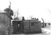
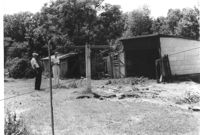
Sheds in dilapidated condition on site affected by the construction of Interstate 26 (I-26). Surveyor notations on back of photo: "Dkt.: 10.480. Property owner: C.G. Hudson. Tract: 250. Station: 5706+30 Lt. Date: May 31, 1961. In R/W - Bought." [See collection description for explanation of surveyor notations.]
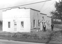
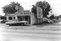
Dorchester Electric Service on site affected by the construction of Interstate 26 (I-26). Building address number 3640 [possibly Dorchester Road]. Front facade has stepped parapet. Partial view of Pick & Pay Bicycle Repair Shop next door. Surveyor notations on back of photo: "Dkt.: 10.480. Property owner: Laura B. Beaufort. Tract: 167. Station: 5681+40 Lt. Date: May 30, 1961. In R/W - Bought." [See collection description for explanation of surveyor notations.]
Building, on site affected by the widening of Route 171 (Folly Road). Dave Richardson and Son General Contractor. Front facade has stepped parapet. Surveyor notations on back of photo: "Dkt.: 10.494. Property owner: Dave Richardson, et al. Tract: 93. Station: 314+40 Lt. Date: Mar. 21, 1962. To be cut off at R/W by SCHD [SC Highway Department?]. [See collection description for explanation of surveyor notations.]
Sheds in dilapidated condition and yard on site affected by the construction of Interstate 26 (I-26). Surveyor notations on back of photo: "Dkt.: 10.480. Property owner: Fred S. Saulters. Tract: 259. Station: 5711+85 Lt. Date: May 31, 1961. Bought." [See collection description for explanation of surveyor notations.]
Right of way--South Carolina--Charleston County, Highway planning--South Carolina--Charleston County, Commercial buildings--South Carolina--Charleston County, Vernacular architecture--South Carolina--Charleston County, Lost architecture--South Carolina--Charleston County✖[remove]35
Charleston County (S.C.)--Buildings, structures, etc.✖[remove]35