House on site affected by the construction of the Crosstown. Address: 259 Ashley Avenue. Surveyor notations on back of photo: "Dkt.: 10.524. Property owner: Madeline H. LaRoache, et al. Tract: 76. Station: 78+10 Rt. Date: Oct. 14, 1964. In R/W - Bought." [See collection description for explanation of surveyor notations.]
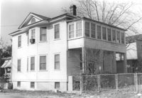
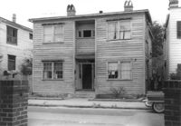
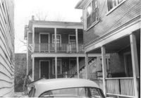
House (corner view, rear) on site affected by the construction of the Crosstown. Address: 270 Ashley Avenue. Surveyor notations on back of photo: "Dkt.: 10.524. Property owner: J. Arthur Brown. Tract: 90. Station: 80+50 Lt. Date: Dec. 1, 1964." [See collection description for explanation of surveyor notations.]
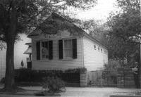
House on site affected by the construction of the Crosstown. Address: 257 Ashley Avenue. Surveyor notations on back of photo: "Dkt.: 10.524. Property owner: Daisey DeCosta Caffry. Tract: 75. Station: 77+95 Rt. Date: Oct. 14, 1964. Proximity." [See collection description for explanation of surveyor notations.]
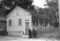
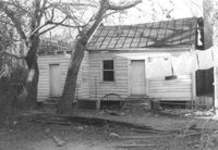
House (freedman's cottage) on site affected by the construction of the Crosstown. Address: 9 Kennedy Street. Surveyor notations on back of photo: "Dkt.: 10.524. Property owner: Emmaline L. Purvis, Est. Tract: 88. Station: 80+92 Rt. Date: Oct. 14, 1964. Proximity." [See collection description for explanation of surveyor notations.]
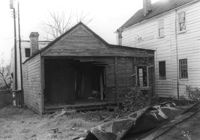
Rear view of house in dilapidated condition (freedman's cottage) on site affected by the construction of the Crosstown. Address: 5 Todd Street. Surveyor notations on back of photo: "Dkt.: 10.524. Property owner: Urban M. Kennedy, Est. Tract: 119. Station: 87+45 CL. Date:: Dec. 2, 1964. In R/W - Bought." [See collection description for explanation of surveyor notations.]
House on site affected by the construction of the Crosstown. Address: 3 Todd Street. On property of previous photos 413-414. Surveyor notations on back of photo: "Dkt.: 10.524. Property owner: John W. Bonaparte, et al. Tract: 118. Station: 87+35 Rt. Date: Dec. 1, 1964. In R/W - Bought." [See collection description for explanation of surveyor notations.]
House on site affected by the construction of the Crosstown. Address: 115 Bogard Street. Surveyor notations on back of photo: "Dkt.: 10.524. Property owner: Susan D. Butler, Est. Tract: 57. Station: 73+65 Lt. Date: Oct. 14, 1964. Portion in R/W to be removed." [See collection description for explanation of surveyor notations.]
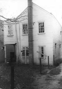
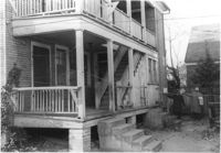
House (rear view) on site affected by the construction of the Crosstown. Address: 502 Rutledge Avenue. Surveyor notations on back of photo: "Dkt.: 10.524. Property owner: Anna R.D. Hollings, Est. Tract: 115. Station: 86+00 Rt. Date: Dec. 1, 1964. In R/W - Bought." [See collection description for explanation of surveyor notations.]
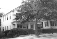
Portions of three houses on site affected by the construction of the Crosstown. Address: 501 Rutledge Avenue. Surveyor notations on back of photo: "Dkt.: 10.524. Property owner: William DeLesline, et al. Tract: 108. Station: 84±85 Lt. Date: Dec. 1, 1964." [See collection description for explanation of surveyor notations.]
House (portion of rear) on site affected by the construction of the Crosstown. Address: 501 Rutledge Avenue. Surveyor notations on back of photo: "Dkt.: 10.524. Property owner: William DeLesline, et al. Tract: 108. Station: 84±35 Lt. Date: Dec. 1, 1964. [See collection description for explanation of surveyor notations.]