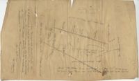
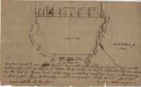
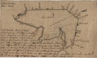
Plat of 89 acres in the Beaufort District. Plat shows the location of several ponds. Little other detail is included. Names associated with this plat are N.H. Johnson, R.J. Marker, Mary Kittles, John H. Raddell [?], and Brown. Notable geographic locations include the Savannah River, Beaufort District and Dry Gull Branch.
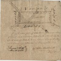
Plat of 220 acres on the Black River belonging to John Luck. Details include the areas of the river and marsh, and the location of trees on the property lines. Names associated with this plat are John Luch and John Hardwick. Notable geographic locations include Black River and Craven County Craven County [now in parts of Berkeley, Charleston, Georgetown, and Williamsburg counties].
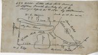
483 acre plot of Little Hell Hole Swamp, includes islands and surrounding property owners doesn't include land detail. Names associated with this plat are H.S. Morrison, Isaac Bishop, W.C. Miller, W.J. Ball, and Anderson. Notable geographic locations include St. Stephens Parish, Hog Pen Island, Little Hell Hole Swamp, and Berkeley County.
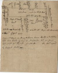
Plat of 250 acres on Wadmalaw Creek. Includes short explanation, but plat itself includes very little details. Names associated with this plat are Hugh McDowel, James McDowel, James Carson, Dalziel Hunter, James Young and Ellis.
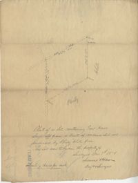
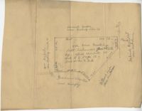
Plat of a land containing ten acres, minimal detail showing the surrounding property owners and two roads; Dills Bluff and unnamed public road. Names associated with this plat are Plenty White, Simons and Howe. Notable geographic locations include Dill's Bluff.
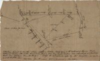
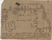
Sketch of property including roads and fields, some specific house names like Rectory house and W. Dotolhinese's house. Names associated with this plat are Glisbe, Priohau, Dotolhinese and Glebe. Notable geographic locations include St. Johns Parish, Broad Road, Wadboo [?] Bridge, Road to Pontauxs, and Road to Cordyville [?].
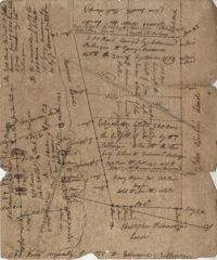
Plan of a body of land now part belonging to Mr. George Summers and part to John Summers and part of the estate of Brigdon Smith lying at Stono adjoining lands of S. Matlock. Names associated with this plat are John Summer, George Summer, Brigdon Smith, Malleck, J. Fenwich, Edward Bellinger, Christopher Wilkenson, John Tucker, W. Owen, Henry Hyrne, Inch, Downs, Elizabeth Elliott, George Tommer, Thomas Farr, Smith Mellichamp, and Ann Downs. Notable geographic locations include New Road, St. Paul's Parish and Stono.
200 acres laid out to Jonathan Stocks situated in Colleton County lying on the side of Kywa [Kiawah] Creek, shows surrounding properties with no land type or detail. Names associated with this plat are Jonathan Stock, John Jones, John Edenborough, Thomas Jones, and Thomas Weatherby.
340 acres of land laid out to George Mitchell on the east side of a branch of Ashepoo River called the Horseshoe Creek. Names associated with this plat are George Mitchell, James St. John, Thomas Broughton and John Andrews. Notable geographic locations include the Ashepoo River and Horseshoe Creek.
Plat includes 624 acres surveyed for Gideon DuPont. Plat does not contain structures. Names associated with this plat are Gideon DuPont, William Thomas Elliot, Captain Daniel Godin, and Middleton. Notable geographic locations are St. Bartholomew's Parish, the Ashepoo River and Deer Creek.
Plat of 500 acres granted to Robert Cahousac January 10,1771. Names associated with this plat are Robert Cahousac, Samuel Cooper, Gabriel Gigneliat [?], Mitchum, Witten, Zachariah Villeponteux, William Mazyck, Juxbury Lumber Co, William Washington, and Charles Parker. Notable geographic locations include St. Bartholomew's Parish and Charleston County.
200 acres laid out to Joan Gryce, on the northwest side of Keywaw [Kiawah] Creek in Colleton County, on the left side it is bordered by the Marshes of Bohicket Creek. Names associated with this plat are Joan Gryce and James Witter. Notable geographic locations include Johns Island, Keywaw [Kiawah] Creek, and Bohicket Creek.
Plat contains 211 acres copied from a release form annexed to Nathaniel Broughton to Alexander Broughton. Part of Mulberry Tract. Names associated with this plat are William John Broughton, Nathaniel Broughton, Alexander Broughton and A. Domini. Notable geographic locations include Doken Creek, The Farm, St. John's Parish and Long Branch Creek.
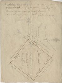
Plat of 300 acres in Berkeley County. Very little detail included in the plat. Names associated with this plat are James McKelvey, John Evans and Sarah Vance. Notable geographic locations include Berkeley County and Russells Creek.
Plan of a tract of land belonging to George Chisolm. Names associated with this plat are George Chisolm, John Scott, A. Andrew, Thomas Hollingsby [?], and Thomas. Notable geographic locations include the Ashley River and Kuskawah [Kushiwah] Creek.
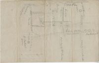
Plat of 1126 acres in St. James Goose Creek on Wasamasaw [Wassamassaw] Swamp. Plat is in pencil and is difficult to read the few details, although there are a few outlines of buildings included, but difficult to tell what they are. Names associated with this plat include Daniel Gelyer, J. Ferrels, Thomas Cusack [?], and James Haney. Notable geographic locations include Wasamasaw [Wassamassaw] Swamp, Sheep Island, Goose Creek, Road to Dorchester, and Ekells Branch.
319 acre plot of land situated on Ocean Bay in St. James Parish, part of the "Hodge Grant," shows some land details like creeks and cypress ponds. Names associated with this plat are T. Hataway, Hodge, W.B. Guerard, Benjamin Fort, B.P. Colburn, Hiram Hodge , R.J. Morrison and W.H. Mellard. Notable geographic locations include Ocean Bay, St. James Parish and Santee.
Plat of land along the Combahee River containing 5567 acres laid out for Daniel Doiley. Names associated with this plat are Daniel Doiley, Smith, Gordon Garrett, and Philips. Notable geographic locations include the Combahee River, Prince William's Parish and Farr Bluff.
General Cutherbert's land on Big Pipe Creek. Names associated with this plat are General Cuthbert, B.H. Roberts, Ball, Peters and David DeSapah [?]. Notable geographic locations include the Savannah River.
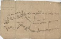
Plan of lands at Bee Creek belonging to Mr. James Bolen called Gray's Hill. Names associated with this plat include James Bolen. Notable geographic locations include St. Lukes Parish, Gray's Hill, Grey's Hill Landing, Bees Creek, and Purrysburgh.