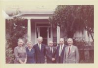
Color photograph depicting image of six people standing in front of McLeod Plantation. Writing on back of image reads, "McLeod house James Island, 1960. L-R -(?) Rose M.L.Barnwell, Dr. E.H. Barnwell (?) W.E. McLeod (?)."
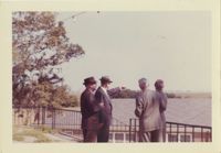
Color photograph of four men looking over rooftop of building. Writing on back of image reads, "Country Club 1960. W.E. McLeod pointing. Others not remembered."
A pamphlet for an exhibit on Jewish participation in the Civil War. Includes a brief overview of the exhibit, a map of Jewish communities in the United States during the Civil War, lists of organizations and individuals who contributed to the exhibit, and a list of objects in the exhibit.
Peach-colored "Free Angela" pin depicting Angela Davis, political activist associated with the Black Panther Party for Self Defense that was established in 1966 in Oakland, California. Pin also reads "Free all political prisoners."
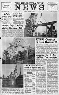
Newspaper printed for the civilian employees of the Charleston Naval Shipyard starting on January 8th 1960. This volume covers from January 8th 1960 to December 23rd 1960.
House on site affected by the construction of Interstate 26 (I-26). Sign posted in ground: Worms for sale. Surveyor notations on back of photo: "Dkt.: 10.471. Property owner: F.R. Shutt, et al. Tract: 92. Station: 5376+10 Rt. Date: Aug. 23, 1960. In R/W - Bought." [See collection description for explanation of surveyor notations.]
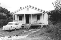
House on site affected by the construction of Interstate 26 (I-26). Surveyor notations on back of photo: "Dkt.: 10.471. Property owner: W.L. McDonald, et al. Tract: 38. Station: 5326+00 Rt. Date: Aug. 23, 1960. In R/W - Bought." [See collection description for explanation of surveyor notations.]
House on site affected by the construction of Interstate 26 (I-26). Surveyor notations on back of photo: "Dkt.: 10.471. Property owner: Isabella W. Meany. Tract: 98. Station: 5378+80 Rt. Date: Aug. 23, 1960. In R/W - Bought." [See collection description for explanation of surveyor notations.]
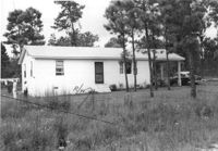
House on site affected by the construction of Interstate 26 (I-26). Surveyor notations on back of photo: "Dkt.: 10.471. Property owner: Annie L. Beattie. Tract: 83. Station: 5364+00 Rt. Date: Aug. 23, 1960. In R/W - Bought." [See collection description for explanation of surveyor notations.]
House on site affected by the construction of Interstate 26 (I-26). Surveyor notations on back of photo: "Dkt.: 10.471. Property owner: E.T. Walling. Tract: 39. Station: 5324+30 Lt. Date: Aug. 23, 1960. In R/W - Bought." [See collection description for explanation of surveyor notations.]
House on site affected by the construction of Interstate 26 (I-26). Surveyor notations on back of photo: "Dkt.: 10.471. Property owner: J.E. Walling. Tract: 41. Station: 5325+15 Rt. Date: Aug. 23, 1960. In R/W - Bought." [See collection description for explanation of surveyor notations.]
House on site affected by the construction of Interstate 26 (I-26). Surveyor notations on back of photo: "Dkt.: 10.471. Property owner: R.B. Evans. Tract: 2. Station: 5155+75 Lt. Date: Aug. 23, 1960. Proximity." [See collection description for explanation of surveyor notations.]