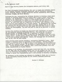
Correspondence from Bernice V. Robinson to the Highlander Staff regarding the Report of the Training Leaders for Citizenship Schools, July 17 to 23, 1961.
University of Wisconsin Rural CAP Training Program course material entitled, "Group Sensitivity Training," excerpted from Carl Rogers', "This is me," in "On Becoming a Person."
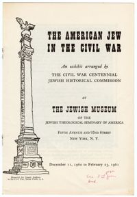
A pamphlet for an exhibit on Jewish participation in the Civil War. Includes a brief overview of the exhibit, a map of Jewish communities in the United States during the Civil War, lists of organizations and individuals who contributed to the exhibit, and a list of objects in the exhibit.
Newspaper printed for the civilian employees of the Charleston Naval Shipyard starting on January 6th 1961. This volume covers from January 6th 1961 to December 29rd 1961.
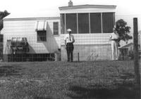
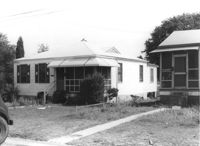
House (rear view) on site affected by the construction of Interstate 26 (I-26). [Building address number 145.] Surveyor notations on back of photo: "Dkt.: 10.480. Property owner: Jerome M. Williams. Tract: 270. Station: 5724+10 Lt. (Line C). Date: May 31, 1961. Proximity." [See collection description for explanation of surveyor notations.]
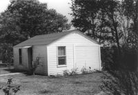
House on site affected by the construction of Interstate 26 (I-26). Possibly on Rivers Avenue. Surveyor notations on back of photo: "Dkt.: 10.486. Property owner: Ernest E. & Nolie C. Grooms. Williams Furniture Corp. Tract: 41. Station: 29+40 Lt. Date: May 30, 1961. In R/W - Bought." [See collection description for explanation of surveyor notations.]
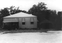
House (corner view, rear) on site affected by the construction of Interstate 26 (I-26). Possibly on Rivers Avenue. Surveyor notations on back of photo: "Dkt.: 10.486. Property owner: Mrs. Mertice S. Greenhill. Tract: 26. Station: 8+50 Lt. (Line E). Date: May 30, 1961. In R/W - Bought." [See collection description for explanation of surveyor notations.]
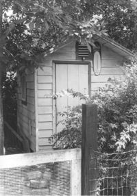
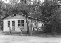
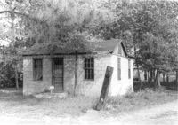
Shed on site affected by the construction of Interstate 26 (I-26). Surveyor notations on back of photo: "Dkt.: 10.480. Property owner: C.H. & Elise V. Meidburg. Tract: 249. Station: 5705+80 Lt. Date: May 31, 1961. In R/W - Bought." [See collection description for explanation of surveyor notations.]
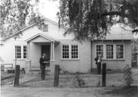
House (corner view, rear) on site affected by the construction of Interstate 26 (I-26). [Building address number 131). Surveyor notations on back of photo: "Dkt.: 10.480. Property owner: Minnie L. Geiger. Tract: 277. Station: 5725+40 Rt. (Line C). Date: May 31, 1961. In R/W - Bought." [See collection description for explanation of surveyor notations.]
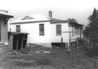
House on site affected by the construction of Interstate 26 (I-26). Building address number 131. Surveyor notations on back of photo: "Dkt.: 10.480. Property owner: Minnie L. Geiger. Tract: 277. Station: 5725+40 Rt. (Line C). Date: May 31, 1961. In R/W - Bought." [See collection description for explanation of surveyor notations.]
Guesthouse? on site affected by the construction of Interstate 26 (I-26). Surveyor notations on back of photo: "Dkt.: 10.480. Property owner: Jessie L. & Doris S. Bercaw. Tract: 272. Station: 5724+85 Rt. (Line C). Date: May 31, 1961. In R/W - Bought." [See collection description for explanation of surveyor notations.]
House on site affected by the construction of Interstate 26 (I-26). Surveyor notations on back of photo: "Dkt.: 10.480. Property owner: Mrs. Sarah Elise P. Ford Thompson. Tract: 260. Station: 5712+20 Lt. Date: May 31, 1961. In R/W - Bought." [See collection description for explanation of surveyor notations.]
House on site affected by the construction of Interstate 26 (I-26). Surveyor notations on back of photo: "Dkt.: 10.480. Property owner: Rebecca R. Wiggins. Tract: 16. Station: 5503+30 Rt. Date: May 2, 1961. In R/W - Bought." [See collection description for explanation of surveyor notations.]
House on site affected by the construction of Interstate 26 (I-26). Surveyor notations on back of photo: "Dkt.: 10.480. Property owner: Central McMillan. Tract: 17. Station: 5503+70 Rt. Date: May 2, 1961. In R/W - Bought." [See collection description for explanation of surveyor notations.]
House on site affected by the construction of Interstate 26 (I-26). Surveyor notations on back of photo: "Dkt.: 10.480. Property owner: John Chaplin. Tract: 18. Station: 5503+90 Rt. Date: May 2, 1961. In R/W - Bought." [See collection description for explanation of surveyor notations.]