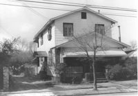
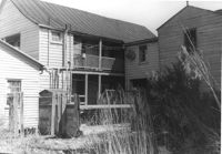
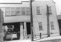
House on site by the construction of Interstate 26 (I-26). Address: 1201 King Street. Surveyor notations on back of photo: "Dkt.: 10.503. Property owner: Gladys Hardy. Tract: 18. Station: 5895+65 Rt. Date: Feb. 19, 1963. In R/W - Bought." [See collection description for explanation of surveyor notations.]
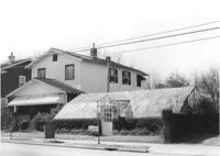
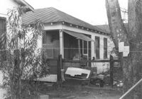
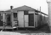
Greenhouse-like structure (plant nursery) on site by the construction of Interstate 26 (I-26). Address: 1205 King Street. Surveyor notations on back of photo: "Dkt.: 10.503. Property owner: Gladys Hardy. Tract: 18. Station: 5895+50 on CL. Date: Feb. 19, 1963. In R/W - Bought." [See collection description for explanation of surveyor notations.]
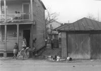
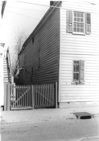
House (rear view) on site affected by the construction of Interstate 26 (I-26). Address: 14 Wood Street. Surveyor notations on back of photo: "Dkt.: 10.503. Property owner: Walter K. Brown. Tract: 32. Station: 5900+10 Lt. Date: Feb. 19, 1963. In R/W - Bought." [See collection description for explanation of surveyor notations.]
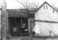
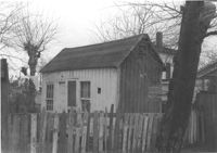
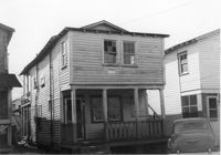
Small dwelling on site affected by the construction of Interstate 26 (I-26). Address: 20½ Poinsett Street. Surveyor notations on back of photo: "Dkt.: 10.503. Property owner: B.W. Donnell, Est. Tract: 101. Station: 5921+00 Lt. Date: Feb. 20, 1963. In R/W - Bought." [See collection description for explanation of surveyor notations.]
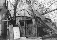
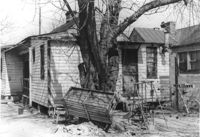
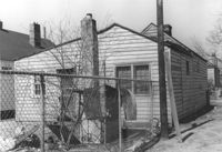
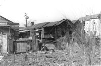
Dilapidated structure on site affected by the construction of Interstate 26 (I-26). Address: 22½ Poinsett Street (rear). Surveyor notations on back of photo: "Dkt.: 10.503. Property owner: J.W. Blanchard, Est. Tract: 102. Station: 5921+00 Lt. Date: Feb. 20, 1963. In R/W - Bought." [See collection description for explanation of surveyor notations.]
Structures on site affected by the construction of Interstate 26 (I-26). Address: 20? Poinsett Street. Surveyor notations on back of photo: "Dkt.: 10.503. Property owner: B.W. Donnell, Est. Tract: 101. Station: 5921+00 Lt. Date: Feb. 20, 1963. In R/W - Bought." [See collection description for explanation of surveyor notations.]
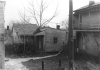
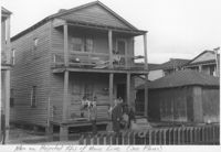
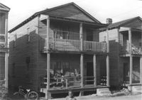
Row of houses on site affected by the construction of Interstate 26 (I-26). Address: 10-14 J Place [between Lenox and Brigade]. (See Sheet 1 of 1951 Sanborn Map.) Surveyor notations on back of photo: "Dkt.: 10.503. Property owner: Gussie Feldman. Tract: 41. Station: 5903+50 Rt. & Lt. In R/W - Bought." [See collection description for explanation of surveyor notations.]
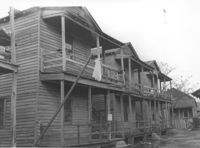
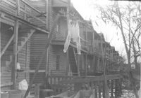
Row of houses (rear view) on site affected by the construction of Interstate 26 (I-26). Address: 20-32 Brigade Street. Surveyor notations on back of photo: "Dkt.: 10.503. Property owner: Gussie Feldman. Tract: 41. Station: 5904±20 Rt. & Lt. Date: Feb. 19, 1963. In R/W - Bought. (Rear of buildings fronting Brigade Street.)" [See collection description for explanation of surveyor notations.]
House (rear view) on site affected by the construction of Interstate 26 (I-26). Address: 9 Maple Street. Surveyor notations on back of photo: "Dkt.: 10.503. Property owner: Kiki Zicoupolis, et al. Tract: 55. Station: 5907+45 CL. Date: Feb. 19, 1963. In R/W - Bought." [See collection description for explanation of surveyor notations.]
Small dwelling on site affected by the construction of Interstate 26 (I-26). Address: 7 Brigade Street. Surveyor notations on back of photo: "Dkt.: 10.503. Property owner: Idella C. Calvin. Tract: 45. Station: 5905+50 Lt. Date. Date: Feb. 19, 1963. In R/W - Bought." [See collection description for explanation of surveyor notations.]
House (rear view) on site affected by the construction of Interstate 26 (I-26). Address: 13 Maple Street. Surveyor notations on back of photo: "Dkt.: 10.503. Property owner: Aliene Cox Tindall. Tract: 53. Station: 5907+65 Rt. Date: Feb. 19, 1963. In R/W - Bought." [See collection description for explanation of surveyor notations.]
House (rear view) on site affected by the construction of Interstate 26 (I-26). Address: 15 Riker Street. Surveyor notations on back of photo: "Dkt.: 10.503. Property owner: Rosa Lee Seabrook. Tract: 70. Station: 5911+40 Lt. Date: May 30, 1963. In R/W - Bought." [See collection description for explanation of surveyor notations.]
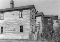
Dwellings on site affected by the construction of Interstate 26 (I-26). Address: 23 Riker Street (rear). Surveyor notations on back of photo: "Dkt.: 10.503. Property owner: Lucille Williams. Tract: 68. Station: 5911+85 Rt. Date: Feb. 20, 1963. In R/W - Bought." [See collection description for explanation of surveyor notations.]
Dwellings on site affected by the construction of Interstate 26 (I-26). Address: 23 Riker Street (rear). Surveyor notations on back of photo: "Dkt.: 10.503. Property owner: Lucille Williams. Tract: 68. Station: 5911+85 Rt. Date: Feb. 20, 1963. In R/W - Bought." [See collection description for explanation of surveyor notations.]
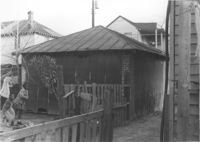
Structure (shed?) on site affected by the construction of Interstate 26 (I-26). Address: within the range of 20-32 Brigade Street. Surveyor notations on back of photo: "Dkt.: 10.503. Property owner: Gussie Feldman. Tract: 41. Station: 5903+92 Lt. Date: Feb. 19, 1963. In R/W - Bought." [See collection description for explanation of surveyor notations.]
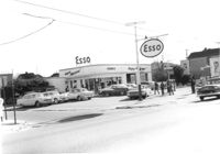
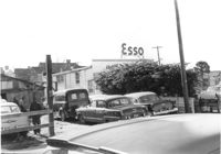
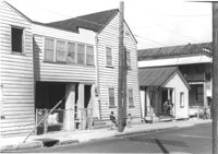
Esso (Humble) gas station (corner view) on site affected by the construction of the Crosstown. Address: 53 Lee Street (corner of Lee Street and Aiken Street). Surveyor notations on back of photo: "Dkt.: 10.518. Property owner: Humble Oil Refining Co. Tract: 51. Station: 46+65 Lt. N.B. lane Route 17. Date: Mar. 6, 1963. In R/W - Bought." [See collection description for explanation of surveyor notations.]
Cars in lot behind Esso (Humble) gas station on site affected by the construction of the Crosstown. Address: 53 Lee Street (corner of Lee Street and Aiken Street). Surveyor notations on back of photo: "Dkt.: 10.518. Property owner: Humble Oil Refining Co. Tract: 51. Station: 46+65 Lt. N.B. lane Route 17. Date: Mar. 6, 1963. In R/W - Bought." [See collection description for explanation of surveyor notations.]
Esso (Humble) gas station on site affected by the construction of the Crosstown. Address: 53 Lee Street (corner of Lee Street and Aiken Street). Surveyor notations on back of photo: "Dkt.: 10.518. Property owner: Humble Oil Refining Co. Tract: 51. Station: 46+65 Lt. N.B. lane Route 17. Date: Mar. 6, 1963. In R/W - Bought." [See collection description for explanation of surveyor notations.]
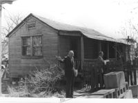
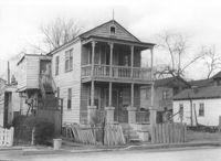
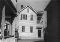
House (freedman's cottage) (rear view) on site affected by the construction of Interstate 26 (I-26). Address: 15½ Addison Street [15 Addison Street]. Surveyor notations on back of photo: "Dkt.: 10.503. Property owner: Evan Gethers, et al. Tract: 100. Station: 5919+80 Lt. Date: Feb. 20, 1963. In R/W - Bought." [See collection description for explanation of surveyor notations.]
House (corner view, rear) on site affected by the construction of Interstate 26 (I-26). Address: 15 Addison Street (rear). Surveyor notations on back of photo: "Dkt.: 10.503. Property owner: Maggie Tobias. Tract: 100-A. Station: 5920+45 Lt. Date: Feb. 20, 1963. Outside R/W bought." [See collection description for explanation of surveyor notations.]
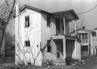
House (rear view) on site affected by the construction of Interstate 26 (I-26). Address: 17 Addison Street. Surveyor notations on back of photo: "Dkt.: 10.503. Property owner: Violet Chapman. Tract: 99. Station: 5919+90 Lt. Date: Feb. 20, 1963. In R/W - Bought." [See collection description for explanation of surveyor notations.]
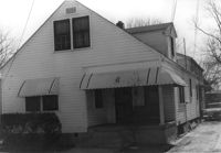
House on site affected by the construction of Interstate 26 (I-26). Address: 19 Addison Street. Surveyor notations on back of photo: "Dkt.: 10.503. Property owner: Ida Tobias Jackson. Tract: 98. Station: 5919+90 CL on Lt. Date: Feb. 20, 1963. In R/W - Bought." [See collection description for explanation of surveyor notations.]
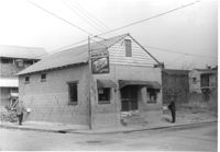
Washington Grocery on site affected by the construction of Interstate 26 (I-26). Address: northeast corner of E Street and C Street. View of street corner. Surveyor notations on back of photo: "Dkt.: 10.517. Property owner: Isaac Washington. Tract: 27. Station: 5946+55 Lt. - Line 6. Date: February 21, 1963." [See collection description for explanation of surveyor notations.]
House on site affected by the construction of Interstate 26 (I-26). Address: 19 Addison Street. Surveyor notations on back of photo: "Dkt.: 10.503. Property owner: Ida Tobias Jackson. Tract: 98. Station: 5920+50 CL on Lt. Date: Feb. 20, 1963. In R/W - Bought." [See collection description for explanation of surveyor notations.]
House on site affected by the construction of Interstate 26 (I-26). Address: 15 Poinsett Street. Surveyor notations on back of photo: "Dkt.: 10.503. Property owner: Josephine Middleton. Tract: 100-B. Station: 5921+70 Lt. Date: Feb. 20, 1963. Proximity." [See collection description for explanation of surveyor notations.]
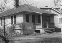
House on site affected by the construction of Interstate 26 (I-26). Address: 99 Romney Street. Surveyor notations on back of photo: "Dkt.: 10.503. Property owner: Handy Felder, et al. Tract: 92-A. Station: 5916+95 Lt. Date: Feb. 20, 1963." [See collection description for explanation of surveyor notations.]
Lot on site affected by the construction of Interstate 26 (I-26). Address: 1204 King Street. Surveyor notations on back of photo: "Dkt.: 10.503. Property owner: Francis Hartnett. Tract: 24. Station: 5897+10 Rt. & Lt. Date: Feb. 19, 1963. In R/W - Bought." [See collection description for explanation of surveyor notations.]
Houses on site affected by the construction of Interstate 26 (I-26). Address: within the range of 20-32 Brigade Street. Handwritten on border of photo: Men on projected R/W of main line (see plans). Surveyor notations on back of photo: "Dkt.: 10.503. Property owner: Gussie Feldman. Tract: 41. Station: 5904+35 Lt. Date: Feb. 19, 1963. In R/W - Bought." [See collection description for explanation of surveyor notations.]
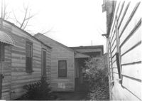
Houses and neighboring shed/garage on site affected by the construction of Interstate 26 (I-26). Address: within the range of 20-32 Brigade Street. Surveyor notations on back of photo: "Dkt.: 10.503. Property owner: Gussie Feldman. Tract: 41. Station: 5904+35 Lt. Date: Feb. 19, 1963. In R/W - Bought." [See collection description for explanation of surveyor notations.]
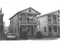
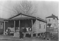
Houses on site affected by the construction of Interstate 26 (I-26). Address: 24 Brigade Street. Neighboring houses on either side also in photo. Surveyor notations on back of photo: "Dkt.: 10.503. Property owner: Gussie Feldman, et al. Tract: 41. Station: 5904+30 Lt. Date: Feb. 19, 1963. In R/W - Bought." [See collection description for explanation of surveyor notations.]
House (rear view) on site affected by the construction of Interstate 26 (I-26). Address: 1194 King Street. Surveyor notations on back of photo: "Dkt.: 10.503. Property owner: J.B. Hodges. Tract: 21. Station: 5897+60 Rt. Date: Feb. 19, 1963. In R/W - Bought." [See collection description for explanation of surveyor notations.]
House (rear view) on site affected by the construction of the Crosstown. Address: 63 Lee Street. Surveyor notations on back of photo: "Dkt.: 10.518. Property owner: Peter Bennett, Est. Tract: 38. Station: 43+65 Rt. S.B. lane Route 17. Date: Mar. 6, 1963. In R/W - Bought. [See collection description for explanation of surveyor notations.]
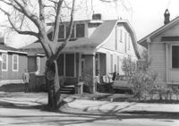
House (rear view) on site affected by the construction of the Crosstown. Address: 74 Cooper Street. Surveyor notations on back of photo: "Dkt.: 10.518. Property owner: Victoria Jenkins, Est. Tract: 21. Station: 40+30 Rt. N.B. lane Route 17. Date: Mar. 6, 1963." [See collection description for explanation of surveyor notations.]
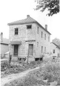
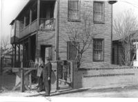
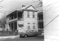
House on site affected by the construction of Interstate 26 (I-26). Address: 1200 King Street. Surveyor notations on back of photo: "Dkt.: 10.503. Property owner: William R. Nelson. Tract: 22. Station: 5897+40 Rt. Date: Feb. 19, 1963. In R/W - Bought." [See collection description for explanation of surveyor notations.]
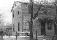
House on site affected by the construction of Interstate 26 (I-26). Address: 10 Lenox Street. Surveyor notations on back of photo: "Dkt.: 10.503. Property owner: Benjamin Thompson. Tract: 37. Station: 5901+50 Lt. Date: Feb. 19, 1963. In R/W - Bought." [See collection description for explanation of surveyor notations.]
House on site affected by the construction of Interstate 26 (I-26). Address: 1194 King Street. Surveyor notations on back of photo: "Dkt.: 10.503. Property owner: J.B. Hodges. Tract: 21. Station: 5897+60 Rt. Date: Feb. 19, 1963. In R/W - Bought." [See collection description for explanation of surveyor notations.]
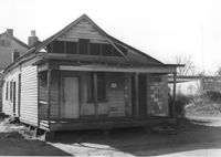
House on site affected by the construction of the Crosstown. Address: 98 Sheppard Street. Surveyor notations on back of photo: "Dkt.: 10.518. Property owner: M.J. Christine Butt, Est. Tract: 19. Station: 29+75 Lt. Sheppard Street. Date: Mar. 6, 1963. In R/W - Bought. [See collection description for explanation of surveyor notations.]
House on site affected by the construction of the Crosstown. Address: 74 Cooper Street. Surveyor notations on back of photo: "Dkt.: 10.518. Property owner: Victoria Jenkins, Est. Tract: 21. Station: 40+30 Rt. N.B. lane Route 17. Date: Mar. 6, 1963." [See collection description for explanation of surveyor notations.]
House on site affected by the construction of Interstate 26 (I-26). Address: 406 Boyer Street (rear). Surveyor notations on back of photo: "Dkt.: 10.503. Property owner: Dora P. Wright. Tract: 79. Station: 5914+00 Lt. Date: Feb. 20, 1963. In R/W - Bought." [See collection description for explanation of surveyor notations.]
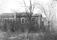
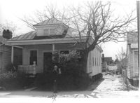
House on site affected by the construction of Interstate 26 (I-26). Address: 6 Indian Street. Surveyor notations on back of photo: "Dkt.: 10.503. Property owner: Gibbs Mitchell, Est. Tract: 75. Station: 5913+45 Rt. Date: Feb. 20, 1963. In R/W - Bought." [See collection description for explanation of surveyor notations.]
House on site affected by the construction of the Crosstown. 74 Cooper Street. Surveyor notations on back of photo: "Dkt.: 10.518. Property owner: Victoria Jenkins, Est. Tract: 21. Station: 40+30 Rt. N.B. lane Route 17. Date: Mar. 6, 1963." [See collection description for explanation of surveyor notations.]
Rear view of houses on site affected by the construction of the Crosstown. Address: 75 Lee Street. Surveyor notations on back of photo: "Dkt.: 10.518. Property owner: Virginia E.R. Ehlers. Tract: 28. Station: 40+50 & 40+75 CL S.B. lane of Route 17. Date: Mar. 6, 1963. In R/W - Bought. [See collection description for explanation of surveyor notations.]
House on site affected by the construction of the Crosstown. Address: 174 Nassau Street. Surveyor notations on back of photo: "Dkt.: 10.518. Property owner: Alberta Jackson Mack. Tract: 31. Station: 42+00 CL N.B. lane Route 17. Date: Mar. 6, 1963. In R/W - Bought. [See collection description for explanation of surveyor notations.]
House on site affected by the construction of the Crosstown. Address: 174 Nassau Street. Surveyor notations on back of photo: "Dkt.: 10.518. Property owner: Alberta Jackson Mack. Tract: 31. Station: 42+00 CL N.B. lane Route 17. Date: Mar. 6, 1963. In R/W - Bought. [See collection description for explanation of surveyor notations.]
House on site affected by the construction of the Crosstown. Address: 73 Lee Street. Surveyor notations on back of photo: "Dkt.: 10.518. Property owner: Virginia E.R. Ehlers. Tract: 28. Station: 40+75 CL S.B. lane Route 17. Date: Mar. 6, 1963. In R/W - Bought. [See collection description for explanation of surveyor notations.]
House on site affected by the construction of Interstate 26 (I-26). Address: 406 Boyer Street. Surveyor notations on back of photo: "Dkt.: 10.503. Property owner: Dora P. Wright. Tract: 79. Station: 5914+00 Lt. Date: Feb. 20, 1963. In R/W - Bought." [See collection description for explanation of surveyor notations.]
House on site affected by the construction of Interstate 26 (I-26). Address: 702 Indian Street. Surveyor notations on back of photo: "Dkt.: 10.503. Property owner: Harold I. Sherman. Tract: 73. Station: 5912+50 Lt. Date: Feb. 20, 1963. In R/W - Bought." [See collection description for explanation of surveyor notations.]
House on site affected by the construction of Interstate 26 (I-26). Address: 15 Indian Street. Surveyor notations on back of photo: "Dkt.: 10.503. Property owner: Anaconda Ltd. Tract: 77. Station: 5913+40 Lt. Date: Feb. 20, 1963. In R/W - Bought." [See collection description for explanation of surveyor notations.]
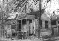
House in dilapidated condition (freedman's cottage) on site affected by the construction of Interstate 26 (I-26). Address: 24 Poinsett Street. Surveyor notations on back of photo: "Dkt.: 10.503. Property owner: Frank Brown, Est. Tract: 104. Station: 5921+70 Rt. Date: Feb. 20, 1963. In R/W - Bought." [See collection description for explanation of surveyor notations.]
House on site affected by the construction of the Crosstown. Address: 174 Nassau Street. Surveyor notations on back of photo: "Dkt.: 10.518. Property owner: Alberta Jackson Mack. Tract: 31. Station: 42+00 CL N.B. lane Route 17. Date: Mar. 6, 1963. In R/W - Bought. [See collection description for explanation of surveyor notations.]