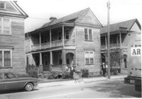
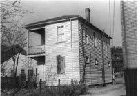
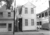
House on site affected by the construction of the Crosstown. Address: 166 Cannon Street. Surveyor notations on back of photo: "Dkt.: 10.524. Property owner: Andrew J. McGuinness, Est. Tract: 1. Station: 59+60 Lt. Date: Oct. 13, 1964. Proximity." [See collection description for explanation of surveyor notations.]
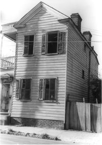
House on site affected by the construction of the Crosstown. Address: 164 Cannon Street. Surveyor notations on back of photo: "Dkt.: 10.524. Property owner: Leola G. McKelvin. Tract: 2. Station: 60+00 Lt. Date: Oct. 13, 1964. Proximity." [See collection description for explanation of surveyor notations.]
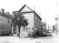
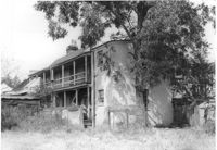
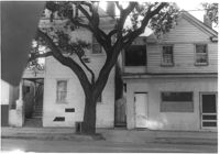
House on Cannon Street, on site affected by the construction of the Crosstown. Address: 162A Cannon Street (address on 1951 Sanborn Map, northwest corner Cannon and Wescott). Surveyor notations on back of photo: "Dkt.: 10.524. Property owner: August Schilling. Tract: 3. Station: 60+50 Lt. Date: Oct. 13, 1964. Partially in R/W." [See collection description for explanation of surveyor notations.]
House (corner view) on Cannon Street, on site affected by the construction of the Crosstown. Address: 162A Cannon Street (address on 1951 Sanborn Map). View of street corner (northwest corner of Cannon Street and Wescott Street). Surveyor notations on back of photo: "Dkt.: 10.524. Property owner: August Schilling. Tract: 3. Station: 60+50 Lt. Date: Oct. 13, 1964. Partially in R/W." [See collection description for explanation of surveyor notations.]
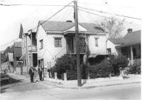
House (corner view) on site affected by the construction of the Crosstown. Address: northeast corner of Cannon Street and Wescott Street. View of street corner. Surveyor notations on back of photo: "Dkt.: 10.524. Property owner: Willie Williams. Tract: 4. Station: 61+00 CL. Date: Oct. 13, 1964. In R/W - Bought." [See collection description for explanation of surveyor notations.]
House (freedman's cottage) on site affected by the construction of the Crosstown. Address: 72 Kracke Street [note: 29 Kracke Street today]. Surveyor notations on back of photo: "Dkt.: 10.524. Property owner: Carlotta Alston. Tract: 67. Station: 76+45 Lt. Date: Oct. 14, 1964. Proximity." [See collection description for explanation of surveyor notations.]
Structure on site affected by the construction of the Crosstown. Address: 122 Sheppard Street. Surveyor notations on back of photo: "Dkt.: 10.524. Property owner: Archie B. Hollins. Tract: 136. Station: 17+40 Lt. S.B. lane. Date: Dec. 2, 1964. Outside R/W." [See collection description for explanation of surveyor notations.]
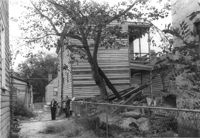
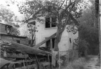
Rear view of house on site affected by the construction of the Crosstown. Address: 5 Rosemont Street. Backyard strewn with wood boards, etc. Surveyor notations on back of photo: "Dkt.: 10.524. Property owner: Harold I. Sherman. Tract: 53. Station: 71+20 Rt. Date: Oct. 14, 1964. Portion in R/W already torn down by property owner." [See collection description for explanation of surveyor notations.]
House (freedman's cottage) on site affected by the construction of the Crosstown. Address: 118 Bogard Street. Surveyor notations on back of photo: "Dkt.: 10.524. Property owner: Marion Holmes Wright, Est., et al. Tract: 62. Station: 75+10 CL Lt. Date: Oct. 14, 1964. Partially in R/W." [See collection description for explanation of surveyor notations.]
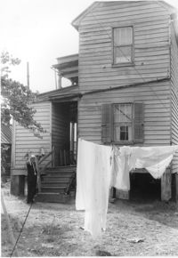
House on Sheppard Street (rear view) on site affected by the construction of the Crosstown. Address: 137 Sheppard Street. Surveyor notations on back of photo: "Dkt.: 10.524. Property owner: Frank Williams. Tract: 126. Station: 89+40 Lt. Date: Dec. 2, 1964. In R/W - Bought." [See collection description for explanation of surveyor notations.]
House on Sheppard Street on site affected by the construction of the Crosstown. Address: 135 Sheppard Street. Surveyor notations on back of photo: "Dkt.: 10.524. Property owner: William Delestine, et al. Tract: 127. Station: 89+80 CL. Date: Dec. 2, 1964. In R/W - Bought." [See collection description for explanation of surveyor notations.]
House on site affected by the construction of the Crosstown. Address: 139 Sheppard Street. Surveyor notations on back of photo: "Dkt.: 10.524. Property owner: Wilmot J. Frasier. Tract: 125. Station: 89+15 Lt. Date: Dec. 2, 1964. In R/W - Bought." [See collection description for explanation of surveyor notations.]
House on site affected by the construction of the Crosstown. Address: 139 Sheppard Street. Surveyor notations on back of photo: "Dkt.: 10.524. Property owner: Wilmot J. Frasier. Tract: 125. Station: 89+15 Lt. Date: Dec. 2, 1964. In R/W - Bought." [See collection description for explanation of surveyor notations.]
House on Sheppard Street on site affected by the construction of the Crosstown. Address: 137 Sheppard Street. Surveyor notations on back of photo: "Dkt.: 10.524. Property owner: Frank Williams. Tract: 126. Station: 89+40 Lt. Date: Dec. 2, 1964. In R/W - Bought." [See collection description for explanation of surveyor notations.]
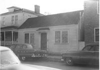
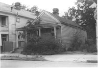
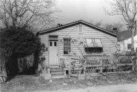
House on site affected by the construction of the Crosstown. Address: 163 Line Street. (Possibly a freedman's cottage with altered entry and porch.) Surveyor notations on back of photo: "Dkt.: 10.524. Property owner: Lucille Beall. Tract: 93. Station: 81+50 CL. Date: Dec. 1, 1964. In R/W - Bought." [See collection description for explanation of surveyor notations.]
Rear view of house on site affected by the construction of the Crosstown. Address: 5 Rosemont Street (rear). Backyard strewn with wood boards, etc. Surveyor notations on back of photo: "Dkt.: 10.524. Property owner: Harold I. Sherman. Tract: 53. Station: 71+70 Rt. Date: Oct. 14, 1964. In R/W - Bought." [See collection description for explanation of surveyor notations.]
House (rear view) on site affected by the construction of the Crosstown. Address: 152-150 Line Street. Surveyor notations on back of photo: "Dkt.: 10.524. Property owner: John N. Peeksen. Tract: 117. Station: 86+70 Rt. Date: Dec. 1, 1964. In R/W." [See collection description for explanation of surveyor notations.]
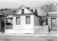
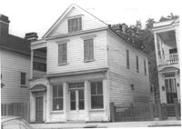
House on site affected by the construction of the Crosstown. Address: 195 Spring Street. Surveyor notations on back of photo: "Dkt.: 10.524. Property owner: Charlotte M. and John Pembroke. Tract: 12. Station: 23+40 Rt. (Spring Street). Date: Oct. 13, 1964. Steps to be removed by property owner; wrought iron fence bought." [See collection description for explanation of surveyor notations.]
Shed and backyard on site affected by the construction of the Crosstown. Address: 112 Sheppard Street. Surveyor notations on back of photo: "Dkt.: 10.524. Property owner: Alston O. Crum, Est. Tract: 146. Station: 19+60 Lt. S.B. lane. Date: Dec. 2, 1964. Proximity." [See collection description for explanation of surveyor notations.]
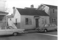
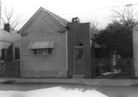
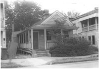
House (freedman's cottage) on site affected by the construction of the Crosstown. Address: 149 President Street. Surveyor notations on back of photo: "Dkt.: 10.524. Property owner: Mamie B. Motte. Tract: 32. Station: 67+90 Rt. Date: Oct. 13, 1964. In R/W - Bought." [See collection description for explanation of surveyor notations.]
House (freedman's cottage) on site affected by the construction of the Crosstown. Address: 149 President Street. Surveyor notations on back of photo: "Dkt.: 10.524. Property owner: Mamie B. Motte. Tract: 32. Station: 67+90 Rt. Date: Oct. 13, 1964. In R/W - Bought." [See collection description for explanation of surveyor notations.]
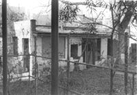
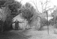
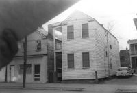
House (rear view) on site affected by the construction of the Crosstown. Address: 22 Wescott Street. Surveyor notations on back of photo: "Dkt.: 10.524. Property owner: Ida J. Gantt. Tract: 10. Station: 61+20 Lt. Date: Oct. 13, 1964. Portion in R/W to be removed by property owner." [See collection description for explanation of surveyor notations.]
House (rear view) on site affected by the construction of the Crosstown. Address: 11 Presidents Place. Surveyor notations on back of photo: "Dkt.: 10.524. Property owner: Lucille Smalls. Tract: 9. Station: 63+10 Rt. Date: Oct. 13, 1964. In R/W - Bought." [See collection description for explanation of surveyor notations.]
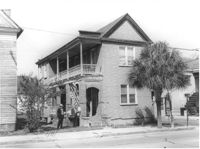
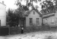
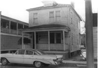
House on site affected by the construction of the Crosstown. Address: 162 Cannon Street. Surveyor notations on back of photo: "Dkt.: 10.524. Property owner: Willie Williams. Tract: 4. Station: 61+15 Rt. Date: Oct. 13, 1964. In R/W - Bought." [See collection description for explanation of surveyor notations.]
House on site affected by the construction of the Crosstown. Address: 162 Cannon Street. Surveyor notations on back of photo: "Dkt.: 10.524. Property owner: Willie Williams. Tract: 4. Station: 61+15 Rt. Date: Oct. 13, 1964. In R/W - Bought." [See collection description for explanation of surveyor notations.]
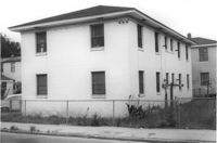
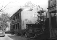
Rear view of apartment building on site affected by the construction of the Crosstown. Address: 123 Bogard Street. Surveyor notations on back of photo: "Dkt.: 10.524. Property owner: Henry W. Smith. Tract: 48. Station: 73+10 CL. Date: Oct. 14, 1964. In R/W - Bought." [See collection description for explanation of surveyor notations.]
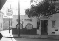
House on site affected by the construction of the Crosstown. Address: 158 Line Street. First story appears to be a store (or office) front. Signs for W.L. Metz, Jr. and H.L. Davis in window. Surveyor notations on back of photo: "Dkt.: 10.524. Property owner: William A. Williams. Tract: 102. Station: 83+70 CL. Date: Dec. 1, 1964. In R/W - Bought. [See collection description for explanation of surveyor notations.]
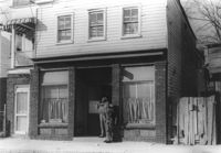
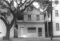
House on site affected by the construction of the Crosstown. Address: 182 Spring Street. First floor appears to have been a store. Surveyor notations on back of photo: "Dkt.: 10.524. Property owner: A.J.R. Kornahrens. Tract: 27. Station: 65+75 Rt. Date: Oct. 13, 1964. In R/W - Bought." [See collection description for explanation of surveyor notations.]
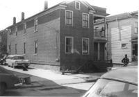
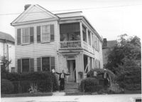
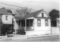
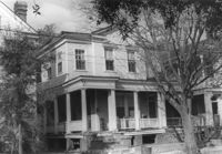
House (and neighboring house) on site affected by the construction of the Crosstown. Address: 495 Rutledge Avenue. Surveyor notations on back of photo: "Dkt.: 10.524. Property owner: Elise C. Goldberg, et al. Tract: 105. Station: 84+15 Rt. Date: Dec. 1, 1964. In R/W - Bought." [See collection description for explanation of surveyor notations.]
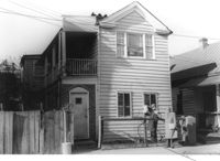
House and driveway on site affected by the construction of the Crosstown. Address: 6 Norman Street. Surveyor notations on back of photo: "Dkt.: 10.524. Property owner: Julia Williams Glover. Tract: 22. Station: 67+00 Lt. Date: Oct. 13, 1964. In R/W - Bought." [See collection description for explanation of surveyor notations.]
House on site affected by the construction of the Crosstown. Address: 10 Kennedy Street. Surveyor notations on back of photo: "Dkt.: 10.524. Property owner: Lucille Beall. Tract: 93. Station: 81+50 CL. Date: Dec. 1, 1964. In R/W - Bought." [See collection description for explanation of surveyor notations.]
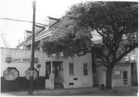
Carl's House on site affected by the construction of the Crosstown. Address: 493 Rutledge Avenue. View of street corner. Neighboring house in photo. Surveyor notations on back of photo: "Dkt.: 10.524. Property owner: Elise C. Goldberg, et al. Tract: 105. Station: 84+40 Rt. Date: Dec. 1, 1964. In R/W - Bought." [See collection description for explanation of surveyor notations.]
House and neighboring houses on site affected by the construction of the Crosstown. Address: 495 Rutledge Avenue and 497 Rutledge Avenue. Surveyor notations on back of photo: "Dkt.: 10.524. Property owner: Elise C. Goldberg, et al. Tract: 105. Station: 84+15 Rt. Date: Dec. 1, 1964. In R/W - Bought." [See collection description for explanation of surveyor notations.]
House (rear view) on Sheppard Street on site affected by the construction of the Crosstown. Address: 131 Sheppard Street. Surveyor notations on back of photo: "Dkt.: 10.524. Property owner: William Delestine, et al. Tract: 127. Station: 89+80 CL. Date: Dec. 2, 1964. In R/W - Bought." [See collection description for explanation of surveyor notations.]
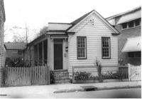
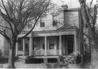
House on site affected by the construction of the Crosstown. Address: 499 Rutledge Avenue. Surveyor notations on back of photo: "Dkt.: 10.524. Property owner: Clinton I. Young. Tract: 107. Station: 84+60 Rt. Date: Dec. 1, 1964. In R/W - Bought." [See collection description for explanation of surveyor notations.]
House on site affected by the construction of the Crosstown. Address: 499 Rutledge Avenue. Surveyor notations on back of photo: "Dkt.: 10.524. Property owner: Clinton I. Young. Tract: 107. Station: 84+60 Rt. Date: Dec. 1, 1964. In R/W - Bought." [See collection description for explanation of surveyor notations.]
House on site affected by the construction of the Crosstown. Address: 497 Rutledge Avenue. Surveyor notations on back of photo: "Dkt.: 10.524. Property owner: Rebecca S. Brown. Tract: 106. Station: 84+50 Rt. Date: Dec. 1, 1964. In R/W - Bought." [See collection description for explanation of surveyor notations.]
House on site affected by the construction of the Crosstown. Address: 497 Rutledge Avenue. Surveyor notations on back of photo: "Dkt.: 10.524. Property owner: Rebecca S. Brown. Tract: 106. Station: 84+50 Rt. Date: Dec. 1, 1964. In R/W - Bought." [See collection description for explanation of surveyor notations.]
House on site affected by the construction of the Crosstown. Address: 9 Todd Street. Surveyor notations on back of photo: "Dkt.: 10.524. Property owner: Daniel Frasier. Tract: 121. Station: 87+90 Lt. Date: Dec. 2, 1964. Partially in R/W." [See collection description for explanation of surveyor notations.]
House on site affected by the construction of the Crosstown. Address: 7 Todd Street. Surveyor notations on back of photo: "Dkt.: 10.524. Property owner: Daniel Frasier. Tract: 120. Station: 87+90 Lt. Date: Dec. 2, 1964. In R/W - Bought." [See collection description for explanation of surveyor notations.]
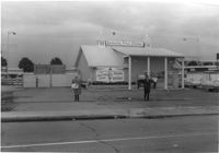
Kentucky Fried Chicken, on site affected by the construction of the Crosstown. Address: 223 Spring Street. Surveyor notations on back of photo: "Dkt.: 10.524. Property owner: Arco Investment Co. Tract: 160 and 161. Station: 17±50 Rt. Spring Street. Date: Dec. 2, 1964." [See collection description for explanation of surveyor notations.]
House on site affected by the construction of the Crosstown. Address: 110 Sheppard Street. Surveyor notations on back of photo: "Dkt.: 10.524. Property owner: Alma L. Browning, et al. Tract: 147. Station: 19+95 CL S.B. lane. Date: Dec. 2, 1964. In R/W - Bought." [See collection description for explanation of surveyor notations.]
House on site affected by the construction of the Crosstown. Address: 110 Sheppard Street. Surveyor notations on back of photo: "Dkt.: 10.524. Property owner: Alma L. Browning, et al. Tract: 147. Station: 19+95 CL S.B. lane. Date: Dec. 2, 1964. In R/W - Bought." [See collection description for explanation of surveyor notations.]