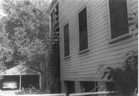
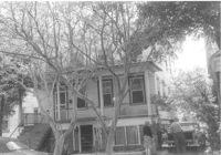
House (side view towards rear) on site affected by the construction of Interstate 26 (I-26). Address: 82 Fishburne Street. Surveyor notations on back of photo: "Dkt.: 10.517. Property owner: Ernest And Mabel Garner. Tract: 125. Station: 23+50 Rt. (Line "1" survey). Date: November 4, 1965. Side view of subject building entirely in R/W. Bought." [See collection description for explanation of surveyor notations.]
House (front and side view) on site affected by the construction of Interstate 26 (I-26). (Presumably where the Crosstown is today or the vicinity.) Address number 82. Surveyor notations on back of photo: "Dkt.: 10.517. Property owner: Ernest And Mabel Garner. Tract: 125. Station: 23+75 Rt. (Line "1" survey). Date: November 4, 1965. Side view of subject building entirely in R/W. Bought." [See collection description for explanation of surveyor notations.]
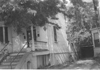
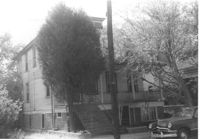
House on site affected by the construction of Interstate 26 (I-26). Address: 84 Fishburne Street. Surveyor notations on back of photo: "Dkt.: 10.517. Property owner: Miss Fannie A. Patrick. Tract: 126. Station: 23+50 Rt. (Line "1" survey). Date: November 4, 1965. Subject building and lot entirely in R/W. Condemned." [See collection description for explanation of surveyor notations.]
House (front and side view) on site affected by the construction of Interstate 26 (I-26). Address: 84 Fishburne Street. Surveyor notations on back of photo: "Dkt.: 10.517. Property owner: Miss Fannie A. Patrick. Tract: 126. Station: 23+50 Rt. (Line "1" survey). Date: November 4, 1965. Side view of building and showing garage in rear, all in R/W. Condemned." [See collection description for explanation of surveyor notations.]
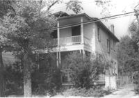
House on site affected by the construction of Interstate 26 (I-26). Address: 7 Carolina Street. Surveyor notations on back of photo: "Dkt.: 10.517. Property owner: Carrie M. Leaphart. Tract: 127. Station: 22+20 Rt. (Line "1" survey). Date: November 4, 1965. Front view of residence. Entire building and lot in R/W." [See collection description for explanation of surveyor notations.]
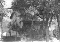
House (front and side view) on site affected by the construction of Interstate 26 (I-26). Address: 7 Carolina Street. Surveyor notations on back of photo: "Dkt.: 10.517. Property owner: Carrie M. Leaphart. Tract: 127. Station: 22+20 Rt. (Line "1"). Date: November 4, 1965. Side view of building and lot that is entirely in R/W." [See collection description for explanation of surveyor notations.]
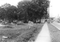
Sign "Opening soon - New 7-11 Food Store," on site affected by the widening of State Road 31 (Reynolds Avenue). Surveyor notations on back of photo: "Dkt.: 10.541. Property owner: Morris P. Sokol, et al. Tract: 1. Station: 2+80 Lt. Date: Apr. 20, 1965. Portion of office building in R/W." [See collection description for explanation of surveyor notations.]
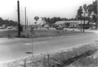
Esso Service Station: at intersection of Orange Grove Road and SC Highway 7 (Sam Rittenberg Boulevard), on site affected by the widening of Routes 7 & 171. Surveyor notations on back of photo: "Dkt.: 10.551. Property owner: Humble Oil Co. Tract: 1. Station: 36±00 Rt. Date: Jul. 22, 1965. West from east side Orange Grove Rd. of range poles on corners of ? area. [See collection description for explanation of surveyor notations.]
Example of information written on back of photograph: Docket Number, Route, County, Property Owner, Tract, Station, Date, and added note pertaining to right-of-way.
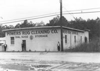
Powers Rug Cleaning Co, on site affected by the widening of Route 171 (Folly Road). Surveyor notations on back of photo: "Dkt.: 10.494. Property owner: K. & Dorothy Ohlinge. Tract: 38. Station: 174+30 Rt. Date: Mar. 21, 1962. Proximity. [See collection description for explanation of surveyor notations.]
Limit your search
SCDOT Photographs: Properties in the Right-of-Way✖[remove]2,276