(Front) 5x8 index card survey of 101, 103, 105, and 107 Bull Street. Notes indicate the state of the dwellings. Includes thumbnail image of the dwellings.
(Front) 5x8 index card survey of 99 and 101 Broad Street. Notes indicate the state of the dwelling. Includes thumbnail image of the dwelling. (Back) "Since survey The tile roof destroyed- The house altered for dwellings"
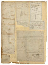
Page 101 of the City Engineer's Plat Book with two plats. Plat 1 shows lots located between Washington Street and Wharf Street, and between Calhoun Street and Laurens Street. Plat 2 shows lots located near the intersection of Rutledge Avenue and Line Street, with several buildings labelled.
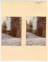
Two colored photographs of the side elevation of No. 101 Bull Street; Left (side elevation with black marks drawn around equipment); Right (side elevation). The two photographs are attached to a beige paper with two holes punched through the top. The paper is labeled as "101 Bull Street SR84-106." The photographs show the side elevation containing both a brick and panel exterior. The section of white horizontal paneling is separated from the brick by a white piazza. The photograph on the left has a handmade drawing that was made around the outdoor housing equipment.
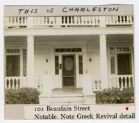
(Front) 5x8 index card survey of 102 Beaufain Street. Notes indicate the state of the dwelling. Includes two thumbnail images of the dwelling. (Back) Notes on building.
Page 102 of the City Engineer's Plat Book with five plats. Plat 1 shows lots along a stretch of Rutledge Avenue from Grove Street to Sans Souci Street. Plat 2 features a projected extension of Rutledge Avenue from Mt. Pleasant Road to Heriot Street, and also shows a lot labelled "S.C. Agricultural Society." Plat 3 shows a projected extension Rutledge Avenue, extending from Sans Souci Street to Mt. Pleasant Road. Plat 4 shows a projected expansion of Rutledge Avenue through Heriot Street, and also shows a plot labelled "Agricultural Society." Plat 5 shows a projected extension of Rutledge Avenue from Grove Street to Simons Street, and also shows King Street.
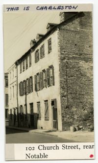
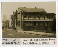
(Front) 5 x 8 index card with survey of 102, 106, and 110 Church Street. Includes one thumbnail image of dwelling. (Back) Signed by A.R.H.S., S.G.S., and A.S.
(Front) 5 x 8 index card with survey of 100 Church Street. Includes one thumbnail image of the building. (Back) Brief notes about the property, including a guess that the property belonged to "Rob't Millis's brother."
Comprehensive Employment and Training Act Title IV project application to the Manpower Division of the Office of the Governor of the State of South Carolina regarding a proposal request.
Page 103 of the City Engineer's Plat Book with three plats. Plat 1 shows lots located between President Street and Norman Street, near where they intersect with Spring Street. Plat 2 shows lots and some buildings along Bogard Street, between Laurel Street and Percy Street. Plat 3 shows a lot and several buildings located on Percy Street.
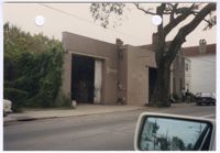
Colored photograph of No. 103 Spring Street. There are two holes punched through the top of the photograph. The photograph shows the cement block structure at No. 103 Spring Street. There is writing painted on beige walls of the north elevation identifying the structure as "Stanley's." There are large garage doors on both sides of the north elevation. The second garage door is slightly obstructed by the oak tree on the sidewalk. There is foliage growing along the west elevation. The photograph was taken from a vehicle. There is a rear view mirror in the bottom right corner of the photograph. The neighboring structures are also visible to the right of No. 103 Spring Street and in the rear view mirror.
Page 104 of the City Engineer's Plat Book with one plat. The plat shows lots located between Moultrie Street and Cunnington Street. It also shows Lemon Street, Lee Street, Price Street, and Magnolia Street. It also shows a plat labelled "Artilery Society" and another plat labelled "Magnolia Cemetery."
United States District Court for the District of South Carolina, Charleston Division, Civil Action No. 79-1042 Affidavit of Wayne Martin, between Earl Davis, Jr. et al. (Plaintiff) versus The City of North Charleston et al. (Defendants).
United States District Court for the District of South Carolina, Charleston Division, Civil Action No. 79-1042 Amended Complaint, between Earl Davis, Jr. et al. (Plaintiff) versus The City of North Charleston et al. (Defendants).
United States District Court for the District of South Carolina, Charleston Division, Civil Action No. 79-1042 Affidavit of John E. Bourne, Jr., between Earl Davis, Jr. et al. (Plaintiff) versus The City of North Charleston et al. (Defendants).
United States District Court for the District of South Carolina, Charleston Division, Civil Action No. 79-1042 Complaint, between Earl Davis, Jr. et al. (Plaintiff) versus The City of North Charleston et al. (Defendants).
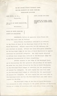
United States District Court for the District of South Carolina, Charleston Division, Civil Action No. 79-1042 Affidavit of Clerk, between Earl Davis, Jr. et al. (Plaintiff) versus The City of North Charleston et al. (Defendants).
United States District Court for the District of South Carolina, Charleston Division, Civil Action No. 79-1042 Affidavit of Earl Davis, between Earl Davis, Jr. et al. (Plaintiff) versus The City of North Charleston et al. (Defendants).
United States District Court for the District of South Carolina, Charleston Division, Civil Action No. 79-1042 Affidavit of Sheryl Smith, between Earl Davis, Jr. et al. (Plaintiff) versus The City of North Charleston et al. (Defendants).
United States District Court for the District of South Carolina, Charleston Division, Civil Action No. 79-1042 Affidavit of Thomas P. Stoney, II, between Earl Davis, Jr. et al. (Plaintiff) versus The City of North Charleston et al. (Defendants).
United States District Court for the District of South Carolina, Charleston Division, Civil Action No. 79-1042 Affidavit of James L. Bridges, between Earl Davis, Jr. et al. (Plaintiff) versus The City of North Charleston et al. (Defendants).
United States District Court for the District of South Carolina, Charleston Division, Civil Action No. 79-1042 Notice of Filing Affidavits, between Earl Davis, Jr. et al. (Plaintiff) versus The City of North Charleston et al. (Defendants).
United States District Court for the District of South Carolina, Charleston Division, Civil Action No. 79-1042 Affidavit of Arthur Watson, between Earl Davis, Jr. et al. (Plaintiff) versus The City of North Charleston et al. (Defendants).
United States District Court for the District of South Carolina, Charleston Division, Civil Action No. 79-1042, between Earl Davis, Jr. et al. (Plaintiff) versus The City of North Charleston et al. (Defendants).
United States District Court for the District of South Carolina, Charleston Division, Civil Action No. 79-1042 Verification, between Earl Davis, Jr. et al. (Plaintiff) versus The City of North Charleston et al. (Defendants).
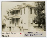
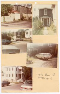
Five colored photographs of No. 104A Bull Street, the two-story outbuilding of No. 104 Bull Street: Top left (south elevation); Top right (front façade/north elevation); Middle left (north and east elevations from a distance); Middle right (west elevation); Bottom left (north and east elevations of No. 104 Bull Street). The five photographs are taped to a beige paper with two holes punched through the top. The paper is labeled "104A Bull St. #797-25-17." The outbuilding is a two-story structure. The exterior of the outbuilding consists of dark shingles and white ornamentation. No. 104 Bull Street is a Neoclassical style of architecture.
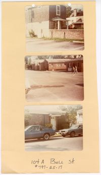
Three colored photographs of No. 104A Bull Street and its neighboring buildings to the west: Top (north and east elevations of No. 104A Bull Street); Middle (series of buildings located to the west of No. 104A Bull Street); (façade of building located to the west of No. 104A Bull Street). The three photographs are attached to a beige paper with two holes punched through the top. The paper is labeled "104A Bull St. #797-25-17." The outbuilding known as No. 104A Bull Street is a two-story structure. The exterior of the outbuilding consists of dark shingles and white ornamentation. The structures to the west of No. 104A Bull Street are single story brick structures.
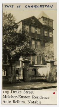
(Front) 5 x 8 index card with survey of 105 Drake Street. Includes three thumbnail images of dwelling. Notes indicate state of dwelling. (Back) Includes notes from Alice Huger Smith on "the general blight" of the neighborhood caused by the location of the Cigar Factory and railway yards, and how the city should have prevented the "degradation" with better zoning. Includes an image of the dwelling.
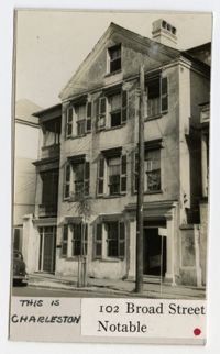
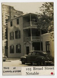
(Front) 5x8 index card survey of rear of 105 Broad Street. Notes indicate the state of the dwelling. Includes thumbnail image of the dwelling. (Back) Notes alterations to the structure.
Page 105 of the City Engineer's Plat Book with seven plats. Plat 1 shows several lots located on Chalmers Street. Plat 2 shows lots located near the intersection of East Bay Street and Market Street, and several structures, including docs and wharves. Plat 3 features lots and structures located on Chalmers Street. Plat 4 features a lot located on the intersection of Church Street and Waters Street, and shows several structures. Plat 5 shows a lot and several structures located on Waters Street. Plat 6 features a lot and buildings located on Broad Street. Plat 7 features the profiles of streets where tidal drains will be built. The profiles include Calhoun Street, Mazyck Street, Logan Street, Tradd Street, Coming Street, Chesnut Street, Spring Street, and Meeting Street.
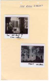
Two colored polaroid photographs of No. 105 Bull Street: Top (north elevation); Bottom (front façade/south elevation). The two photographs are attached to a beige paper with two holes punched through the top. The paper is labeled "105 Bull Street." The front facade of the structure indicates that No. 105 Bull Street is a blue row house. There are handwritten descriptions on each polaroid photograph. The top photograph has an arrow drawn within the photograph pointing upwards with a handwritten note indicating the new location for two meters. The handwritten label on the top photograph labels the photograph as “Rear 105 Bull.” The handwritten label on the bottom photograph labels the photograph as “Front 105 Bull.”
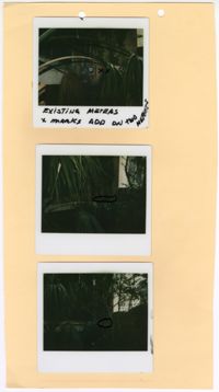
Three colored polaroid photographs of existing meters assumed to be located at No. 105 Bull Street: Top (existing meter); Middle (mark for new meter); Bottom (mark for new meter). The three photographs are attached to a beige paper with two holes punched through the top. There is writing in black ink on the top photograph indicating the existing meter. There are black marks on the middle and bottom photographs indicating the placement of the new meters. The paper is not labeled. The close up photographs each show large amounts of vegetation blocking the structure from view, limiting ability to confirm the address of the photographs.
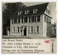
(Front) 5x8 index card survey of 106 Broad Street (John Lining House). Notes indicate the state of the dwelling. Includes two thumbnail images of the dwelling. (Back) Notes on John Lining and history of house.
Page 106 of the City Engineer's Plat Book with ten plats. Plat 1 features a lot and its buildings located near the intersection of King Street and Tradd Street. Plat 2 features a lot and buildings located between Church Street and Water Street, near where the latter intersects with East Bay Street. Plat 3 shows lots located near the intersection of King Street and Grove Street. Plat 4 features a plat and building located on Church Street. Plat 5 features a lot located on the intersection of East Bay Street and Elliott Street. Plat 6 shows a lot located between two streets leading to wharves. Plat 7 shows lots, wharves, and docks located near the intersection of Market Street and East Bay Street. Plat 8 features a wharf and lot located near the intersection of Legare Street and South Bay Street. Plat 9 shows lots located on and near the intersection of Broad Street and East Bay Street. Plat 10 shows lots and some structures located on East Bay Street.
Page 107 of the City Engineer's Plat Book with two plats, labelled 3 and 4. Plat 3 features a lot and buildings located on the intersection or Tradd Street and East Bay Street. Plat 4 shows lots located near Gibbes Street, Tradd Street, New Street, and Savage Street. Plat 4 also shows three lines, labelled "Edge of high land," "Low water by Parker," and "Edge of Channel by Purcell and Parker."
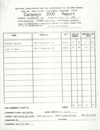
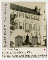
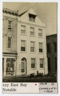
(Front) 5 x 8 index card with survey of 107 East Bay Street. Includes one thumbnail image of dwelling. (Back) Notes about the property and surrounding houses, including "Restoration by Stephen Thomas."
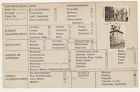
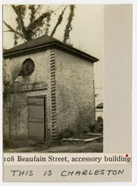
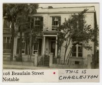
(Front) 5x8 index card survey of 108 Beaufain Street. Notes indicate the state of the dwelling. Includes two thumbnail images of the dwelling. (Back) Notes on building.
Page 108 of the City Engineer's Plat Book with five plats. Plat 1 features lots and some structures located near South Bay Street's intersections with Meeting Street and Church Street. It also shows a lot labelled "Battery Garden." Plat 2 shows lots located near East Bay Street. Plat 3 features White Point Garden, also known as Battery Park, located south of South Battery Street, near the Church Street and Meeting Street. Plat 4 shows a lot located near the intersection of Meeting Street and Broad Street. Plat 5 shows land located between Broad Road and the Ashley River, and includes labels marking salt marshes, cleared lands, a fish pond.
(Front) 5 x 8 index card with survey of 108 Church Street. Includes two thumbnail images of dwelling, one depicting an arch. (Back) Brief notes about the property, including A.R.H.S.'s speculation that the building once housed a tavern, "i.e. a place of first class entertainments."
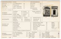
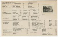
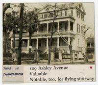
(Front) 5x8 index card survey of 109 Ashley Avenue. Notes indicate the state of the dwelling. Includes thumbnail image of the dwelling. (Back) Notes on building.
Page 109 of the City Engineer's Plat Book with six plats. Plat 1 shows lots located near the intersection of Exchange Street and Champney Street. Plat 2 shows lots and some buildings located on Church Street. Plat 3 shows lots located along Elliott Street, between East Bay and Church Street. Plat 4 shows lots and structures located near the corner of Church Street and Atlantic Street. Plat 5 shows lots and structures located near the corner of Church Street and Atlantic Street. Plat 6 shows lots and structures located near the intersection of East Bay Street and Guignard Street.
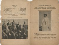
Graduation program for the Eighth Annual Graduating Excercises for the Hospital and Training School for Nurses, which was held at Zion Presbyterian Church on May 26, 1908.
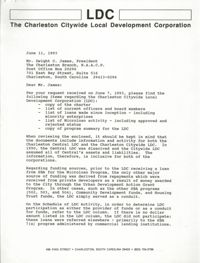
Correspondence from Sharon A. Brennan, Development Coordinator for the Charleston Citywide Local Development Corporation, to Dwight C. James, President of the Charleston Branch of the NAACP, with enclosed copy of charter, list of current officers and board members, list of loans made since inception, list of Microloan activity, and a copy of program summary for the LDC.
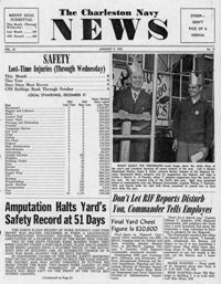
Newspaper printed for the civilian employees of the Charleston Naval Shipyard starting on January 9th 1953. This volume covers from January 11th 1952 to December 18th 1953.
Prentiss Avery Walton (b. 1995). His parents met when his father, a USA citizen, was visiting relatives stationed in a military base in Panama. Walton was born in Williamsburg, Virginia but spent most of his childhood in Rock Hill, South Carolina. His mother homeschooled him and his siblings. In 2006, affected by the declining USA economy, the family relocated to Panama. Walton lived there until he was 16 years old and returned to the USA to finish high school and attend college. In the interview, Walton reflects about growing up in a Black-Latino-Muslim family in two different countries. He talks about being a Citadel cadet, his involvement with campus life as a member of National Coalition Building Institute (NCBI), the Gay-Straight Alliance, and Student Association for Latin and Spanish Awareness (SALSA), and his dreams and plans for the future. Finally, he tells about his fears related to the effects of Trump's racist rhetoric on his communities.
Cheryl Daniels was born in Jersey City, New Jersey. Both of Cheryl?s parents were also born in Jersey City and their parents immigrated from Galway and Cork. Cheryl?s grandparents initially immigrated to America for better job opportunities. She discusses their journey to Americanize themselves upon entering the country by changing their names. She discusses the influence of Catholicism on her family and her public school education experience in America. Cheryl has lived in New Jersey, Colorado, and South Carolina.
Diana Salazar Guzman was born in 1964 in Homestead, Florida. In this interview, she reflects on her Chicana identity and her family roots. Salazar Guzman remembers her role in leading the 2006 immigrant-rights march in Charleston and the challenges she confronted. She talks about her continued community work and the changes she has observed with the growing presence of the Latino community in South Carolina.
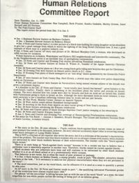
Human Relations Committee Report from Ron Campbell, Herb Frazier, Sandra Gadsden, Shirley Greene, Janet Hartsell, and Jill Norman to the Post-Courier Staff.
Correspondence from Ben A. Hagood, President of the Historic Charleston Foundation, to Septima P. Clark regarding a luncheon featuring speaker, Graham Ashworth, on the topic of Preservation and the Business Community.
Correspondence from William Saunders to Lynn Beasley regarding the nomination of Thomasina Martin Richardson for Charleston County on the Board of Directors of the Palmetto-Lowcountry Health Systems Agency.
Correspondence from Betty Jean Hall, Director of Coal Employment Project, to Bernice Robinson sending her best wishes for a healthy recovery from an illness.