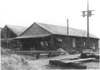
Cole Lumber Company structures, on site affected by the construction of Interstate 26 (I-26). Address from 1961 City Directory: 293 Huger Street. Address from 1951 Sanborn Map: 17 Huger Street. Surveyor notations on back of photo: "Dkt.: 10.517. Property owner: Cole Lumber Co. Tract 1. Station: 5939+50 CL. Date: February 21, 1963." [See collection description for explanation of surveyor notations.]
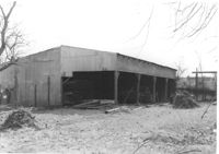
Cole Lumber Company structure, on site affected by the construction of Interstate 26 (I-26). Address from 1961 City Directory: 293 Huger Street. Address from 1951 Sanborn Map: 17 Huger Street. Surveyor notations on back of photo: "Dkt.: 10.517. Property owner: Cole Lumber Co. Tract 1. Station: 5940+00 Lt. Date: February 21, 1963." [See collection description for explanation of surveyor notations.]
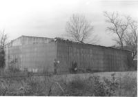
Cole Lumber Company structure (rear view), on site affected by the construction of Interstate 26 (I-26). Address from 1961 City Directory: 293 Huger Street. Address from 1951 Sanborn Map: 17 Huger Street. Surveyor notations on back of photo: "Dkt.: 10.517. Property owner: Cole Lumber Co. Tract 1. Station: 5940+00 Lt. Date: February 21, 1963." [See collection description for explanation of surveyor notations.]
Right of way--South Carolina--Charleston County, Highway planning--South Carolina--Charleston County, Lost architecture--South Carolina--Charleston County, Lumber-yards--South Carolina--Charleston County✖[remove]13