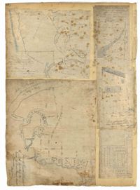
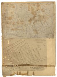
Page 78 of the City Engineer's Plat Book with five plats. Plat 1 features land and lots located near the Ashley River, including geographic features such as marshland, high land, and bodies of water. Plat 1 also shows Boundary Street, Hutson Street, Doughty Street, Bee Street, Elliot Street, Cannon Street, President Street, and Thomas Street. Plat 2 shows a city block between Doughty Street and Bee Street, and between President Street and Thomas Street, with some marsh labelled. Plat 3 features land and lots located near the Ashley River, with shoals and streams labelled. Plat 3 also shows Boundary Street, Pinckney Street, Cannon Street, Hutson Street, Doughty Street, and Bee Street. Plat 4 shows lots located near the intersection of Calhoun Street and Lucas Street, and shows several structures and a stretch of a creek. Plat 5 shows lots features lots located between Lucas Street and Ashley Street, and Mill Street and Doughty Street. Plat 5also shows Palmetto Street, President Street, and a lot labelled "U. S. Arsenal Square."
Page 77 of the City Engineer's Plat Book with seven plats, labelled 1 through 8 with Plat 3 missing. Plat 1 shows lots located between Smith Street and King Street, and between Morris Street and Radcliffe Street. Plat 1 also shows Coming Street and St. Philips Street, and a label reading "Bethlohim Congregation." Plat 2 shows lots and some structures near the intersection of King Street and Warren Street. Plat 4 shows lots between Smith Street and King Street, and north of Radcliffe Street. Plat 4 also shows Coming Street, St. Philips Street, Morris Street, and a lot labelled "Bethlehem Congregation." Plat 5 shows lots located near the intersection of Morris Street and St. Philips Street. Plat 6 shows lots located between Morris Street and "Hunter St now Line," and east of Coming Street. Plat 8 features a lot and structures located on the corner of St. Philips Street and Morris Street.
Page 83 of the City Engineer's Plat Book with eight plats. Plat 1 shows lots and some buildings located near Amherst Street, between Hanover Street and Nassau Street. Plat 2 shows lots located near the intersection of Mary Street and America Street, including a lot with structures including stables, a coach house, and a kitchen. Plat 3 shows lots located on Bay Street, near its intersections with North Street, Cooper Street, Drake Street, and Columbus Street. Plat 4 shows lots located along Drake Street, between Reid Street and Amherst Street. Plat 5 shows lots located on Meeting Street and Line Street. Plat 6 shows lots located near Line Street, between Meeting Street and Nassau Street. Plat 7 shows lots located near the intersection of Meeting Street and Columbus Street, and also shows a small Stretch of Spring Street. Plat 8 shows lots along Line Street, between Meeting Street and Aiken Street.
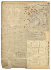
Page 79 of the City Engineer's Plat Book with six plats. Plat 1 shows a lots and some structures located between Doughty Street and Palmetto Street, and also shows Ashley Street and a structure labelled "United States Arsenal Wall." Plat 2 shows lots located near the intersection of Bee Street and President Street. Plat 3 shows lots located on Doughty Street, between Ashley Street and Rutledge Street. Plat 4 features lots and land located near the intersection of Bee Street and President Street. The plat also shows a mill pond and several structures. Plat 5 shows lots located between Doughty Street and Mill Street, and near Ashley Street. Plat 5 also shows Palmetto Street and a lot labelled U. S. Arsenal. Plat 6 shows lots located between Thomas Street and Pinckney Street, with several structures.
Page 82 of the City Engineer's Plat Book with five plats. Plat 1 shows lots located near the intersection of King Street with Sheppard Street. Plat 2 shows lots surrounding Hampstead Mall, between Bay Street and Meeting Street, and between Bull Street and South Street. Plat 2 also shows America Street, Amherst Street, Columbus Street, and a lot labelled "Medical Society." Plat 3 shows lots located on or near Spring Street, between King Street and Meeting Street. Plat 4 features lots near Hampstead Mall, near America Street, Aiken Street, and Columbus Street. Plat 5 features lots located on and near Meeting Street, between Woolfe Street and Columbus Street. Plat 5 also shows Nassau Street and a lot labelled "Tevole Garden."
Page 94 of the City Engineer's Plat Book with two plats. Plat 1 shows lots and marshlands located near Meeting Street, and also shows King Street. Plat 2 features lots located between Meeting Street and a strip labelled "South Carolina R.R. Company." Plat 2 also shows Romney Street and Poinsett Street.
Page 95 of the City Engineer's Plat Book with four plats. Plat 1 shows lots located between Mount Street and Congress Street, and between Rutledge Street and Payne Street. Plat 2 features lots near Meeting Street, and shows a stretch of low ground. Plat 3 shows lots located near Mount Street, Payne Street, and Lowndes Court. Plat 4 shows lots located on Fishburne Street.
Page 96 of the City Engineer's Plat Book with two plats. Plat 1 shows lots located between King Street and Congress Street, and also shows Pinckney Street, Huger Street, and Moultrie Street. Plat 2 shows lots located near the intersection of Payne Street and Line Street, and also shows Kennedy Street.
Page 7 of the City Engineer's Plat Book with four plats. Plat 1 shows lots on Bay Street. Plat 2 features plots on Hanover Street near the intersection with Reid Street and shows a lot labelled "African Burial Ground." Plat 3 features lots between Payne Street and Rutledge Street, near Fishburne Street and Market Street. Plat 4 shows lots and buildings near the intersection King Street and Broad Street. Plat 5 features lots on Cumberland Street.
Page 5 of the City Engineer's Plat Book with three plats. Plat 1 shows plots near Meeting Street, Russell Street, King Street, and a creek labelled "Small Creek." Plat 2 shows plots of land near the intersection of Water Street and Church Street. Plat 3 shows Calhoun Street where it intersects with Ashley Street and Lynch Street, and shows a lot labeled "St. Xavier's Infirmary."