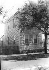
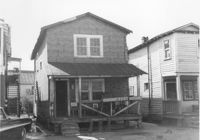
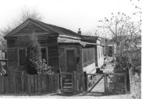
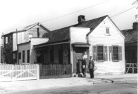
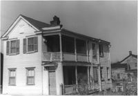
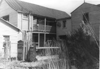
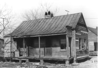
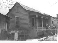
House on site affected by the construction of the Crosstown. Address: 282 Coming Street. Surveyor notations on back of photo: "Dkt.: 10.518. Property owner: M.J. Christine Butt, Est. Tract: 20. Station: 22+25 Rt. S.B. lane Route 17. Date: Mar. 6, 1963. In R/W - Bought. [See collection description for explanation of surveyor notations.]
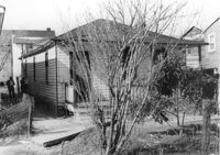
House (rear view) on site affected by the construction of Interstate 26 (I-26). Address: 27 Indian Street. ((1951 Sanborn map indicates the address is 17 Indian Street.) Surveyor notations on back of photo: "Dkt.: 10.503. Property owner: Eloise Williams. Tract: 76. Station: 5913+30 Lt. Date: Feb. 20, 1963. In R/W - Bought." [See collection description for explanation of surveyor notations.]
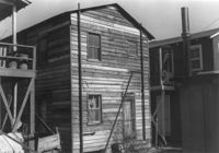
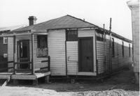
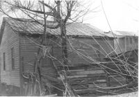
Shed on site affected by the construction of Interstate 26 (I-26). Address: 27 Indian Street. (1951 Sanborn map indicates the address is 17 Indian Street.) Surveyor notations on back of photo: "Dkt.: 10.503. Property owner: Eloise Williams. Tract: 76. Station: 5913+90 Lt. Date: Feb. 20, 1963. In R/W - Bought." [See collection description for explanation of surveyor notations.]
House (rear view) on site affected by the construction of Interstate 26 (I-26). Address: 15 Indian Street. Surveyor notations on back of photo: "Dkt.: 10.503. Property owner: Anaconda Ltd. Tract: 77. Station: 5913+40 Lt. Date: Feb. 20, 1963. In R/W - Bought." [See collection description for explanation of surveyor notations.]
House on site affected by the construction of Interstate 26 (I-26). Address: 15 Indian Street. Surveyor notations on back of photo: "Dkt.: 10.503. Property owner: Anaconda Ltd. Tract: 77. Station: 5913+40 Lt. Date: Feb. 20, 1963. In R/W - Bought." [See collection description for explanation of surveyor notations.]
House on site affected by the construction of Interstate 26 (I-26). Address: 23 Indian Street. (1951 Sanborn map indicates the address is 13 Indian Street.) Surveyor notations on back of photo: "Dkt.: 10.503. Property owner: Katie Johnson. Tract: 78. Station: 5913+40 Lt. Date: Feb. 20, 1963. In R/W - Bought." [See collection description for explanation of surveyor notations.]
House (rear view) on site affected by the construction of Interstate 26 (I-26). Address: 23 Indian Street. (1951 Sanborn map indicates the address is 13 Indian Street.) Surveyor notations on back of photo: "Dkt.: 10.503. Property owner: Katie Johnson. Tract: 78. Station: 5913+40 Lt. Date: Feb. 20, 1963. In R/W - Bought." [See collection description for explanation of surveyor notations.]
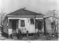
House on site affected by the construction of Interstate 26 (I-26). Address: 11 Indian Street. Surveyor notations on back of photo: "Dkt.: 10.503. Property owner: Ben Rogers. Tract: 78-A. Station: 5913+20 Lt. Date: Feb. 20, 1963. Proximity." [See collection description for explanation of surveyor notations.]
House on site affected by the construction of Interstate 26 (I-26). Address: 11 Indian Street. Surveyor notations on back of photo: "Dkt.: 10.503. Property owner: Ben Rogers. Tract: 78-A. Station: 5913+20 Lt. Date: May 30, 1963. Proximity." [See collection description for explanation of surveyor notations.]
House (rear view) on site affected by the construction of Interstate 26 (I-26). Address: 406 Boyer Street. Surveyor notations on back of photo: "Dkt.: 10.503. Property owner: Dora P. Wright. Tract: 79. Station: 5914+00 Lt. Date: Feb. 20, 1963. In R/W - Bought." [See collection description for explanation of surveyor notations.]
House on site affected by the construction of Interstate 26 (I-26). Address: 406 Boyer Street. Surveyor notations on back of photo: "Dkt.: 10.503. Property owner: Dora P. Wright. Tract: 79. Station: 5914+00 Lt. Date: Feb. 20, 1963. In R/W - Bought." [See collection description for explanation of surveyor notations.]
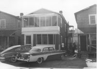
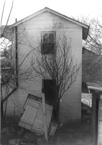
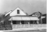
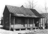
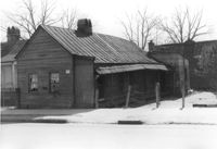
House on site affected by the construction of the Crosstown. 74 Cooper Street. Surveyor notations on back of photo: "Dkt.: 10.518. Property owner: Victoria Jenkins, Est. Tract: 21. Station: 40+30 Rt. N.B. lane Route 17. Date: Mar. 6, 1963." [See collection description for explanation of surveyor notations.]
House on site affected by the construction of Interstate 26 (I-26). Address: 406 Boyer Street (rear). Surveyor notations on back of photo: "Dkt.: 10.503. Property owner: Dora P. Wright. Tract: 79. Station: 5914+00 Lt. Date: Feb. 20, 1963. In R/W - Bought." [See collection description for explanation of surveyor notations.]
House (rear view) on site affected by the construction of Interstate 26 (I-26). Address: 406 Boyer Street (rear). Surveyor notations on back of photo: "Dkt.: 10.503. Property owner: Dora P. Wright. Tract: 79. Station: 5914+00 Lt. Date: Feb. 20, 1963. In R/W - Bought." [See collection description for explanation of surveyor notations.]
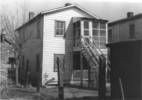
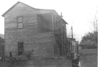
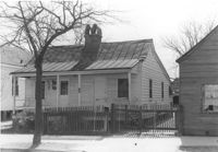
House (rear view) on site affected by the construction of Interstate 26 (I-26). Address: 19 Boyer Street. Surveyor notations on back of photo: "Dkt.: 10.503. Property owner: Ernest Garner. Tract: 80. Station: 5914+35 Lt. Date: Feb. 20, 1963. In R/W - Bought." [See collection description for explanation of surveyor notations.]
House on site affected by the construction of Interstate 26 (I-26). Address: 19 Boyer Street. Surveyor notations on back of photo: "Dkt.: 10.503. Property owner: Ernest Garner. Tract: 80. Station: 5914+35 Lt. Date: Feb. 20, 1963. In R/W - Bought." [See collection description for explanation of surveyor notations.]
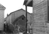
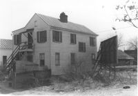
Lot behind houses on site affected by the construction of Interstate 26 (I-26). Address: 157C Russell Street [157 Russell Street]. Rear of 102 Romney Street in background (two-story house). Surveyor notations on back of photo: "Dkt.: 10.503. Property owner: Violet Cone. Tract: 82. Station: 5914+80 Rt. Date: Feb. 20, 1963. In R/W - Bought." [See collection description for explanation of surveyor notations.]
House (freedman's cottage) on site affected by the construction of Interstate 26 (I-26). Address: 110 Russell Street. (1951 Sanborn map indicates the address is 157A Russell Street [157 Russell Street].) Surveyor notations on back of photo: "Dkt.: 10.503. Property owner: Arline Williams. Tract: 83. Station: 5915+00 Rt. Date: Feb. 20, 1963. In R/W - Bought." [See collection description for explanation of surveyor notations.]
House (rear view) on site affected by the construction of Interstate 26 (I-26). 157C Russell Street [157 Russell Street]. Surveyor notations on back of photo: "Dkt.: 10.503. Property owner: Addie Walker. Tract: 84. Station: 5914+65 Lt. Date: Feb. 20, 1963. In R/W - Bought." [See collection description for explanation of surveyor notations.]
House on site affected by the construction of Interstate 26 (I-26). Address: 157C Russell Street [157 Russell Street]. Surveyor notations on back of photo: "Dkt.: 10.503. Property owner: Addie Walker. Tract: 84. Station: 5914+65 Lt. Date: Feb. 20, 1963. In R/W - Bought." [See collection description for explanation of surveyor notations.]
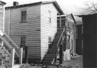
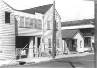
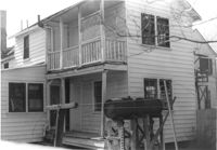
Houses and outbuilding (rear view) on site affected by the construction of Interstate 26 (I-26). Address: 17 Boyer Street. Surveyor notations on back of photo: "Dkt.: 10.503. Property owner: Addie Walker. Tract: 84. Station: 5914+60 Lt. Date: Feb. 20, 1963. In R/W - Bought." [See collection description for explanation of surveyor notations.]
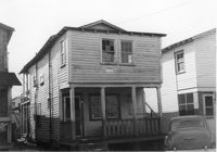
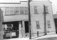
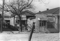
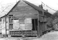
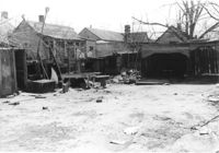
Walker's Grocery and house (behind grocery) on site affected by the construction of Interstate 26 (I-26). Address: 17 Boyer Street. Surveyor notations on back of photo: "Dkt.: 10.503. Property owner: Addie Walker. Tract: 84. Station: 5914+60 Lt. Date: Feb. 20, 1963. In R/W - Bought." [See collection description for explanation of surveyor notations.]
House on site affected by the construction of the Crosstown. Address: 74 Cooper Street. Surveyor notations on back of photo: "Dkt.: 10.518. Property owner: Victoria Jenkins, Est. Tract: 21. Station: 40+30 Rt. N.B. lane Route 17. Date: Mar. 6, 1963." [See collection description for explanation of surveyor notations.]
House on site affected by the construction of Interstate 26 (I-26). Address: 9 Boyer Street. Surveyor notations on back of photo: "Dkt.: 10.503. Property owner: Atlantic Coast Life Ins. Co. Tract: 85. Station: 5914+95 Lt. Date: Feb. 20, 1963. In R/W - Bought." [See collection description for explanation of surveyor notations.]
House (rear view) on site affected by the construction of Interstate 26 (I-26). Address: 9 Boyer Street. Surveyor notations on back of photo: "Dkt.: 10.503. Property owner: Atlantic Coast Life Ins. Co. Tract: 85. Station: 5914+95 Lt. Date: Feb. 20, 1963. In R/W - Bought." [See collection description for explanation of surveyor notations.]
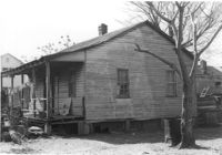
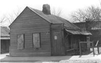
House (freedman's cottage) on site affected by the construction of Interstate 26 (I-26). Address: 102 Romney Street. Surveyor notations on back of photo: "Dkt.: 10.503. Property owner: Mary G. Dawson. Tract: 86. Station: 5915+60 Lt. Date: Feb. 20, 1963. In R/W - Bought." [See collection description for explanation of surveyor notations.]
House (freedman's cottage) (rear view) on site affected by the construction of Interstate 26 (I-26). Address: 102 Romney Street. Surveyor notations on back of photo: "Dkt.: 10.503. Property owner: Mary G. Dawson. Tract: 86. Station: 5915+60 Lt. Date: Feb. 20, 1963. In R/W - Bought." [See collection description for explanation of surveyor notations.]
House (rear view) on site affected by the construction of Interstate 26 (I-26). Address: 104 Romney Street. Surveyor notations on back of photo: "Dkt.: 10.503. Property owner: Sidney Goff. Tract: 87. Station: 5915+80 Lt. Date: Feb. 20, 1963. In R/W - Bought." [See collection description for explanation of surveyor notations.]
House on site affected by the construction of Interstate 26 (I-26). Address: 104 Romney Street. Surveyor notations on back of photo: "Dkt.: 10.503. Property owner: Sidney Goff. Tract: 87. Station: 5915+80 Lt. Date: Feb. 20, 1963. In R/W - Bought." [See collection description for explanation of surveyor notations.]
House on site affected by the construction of Interstate 26 (I-26). Address: 106 Romney Street. Surveyor notations on back of photo: "Dkt.: 10.503. Property owner: Thelma Grant, et al. Tract: 88. Station: 5916+00 Rt. Date: Feb. 20, 1963. In R/W - Bought." [See collection description for explanation of surveyor notations.]
House (rear view) on site affected by the construction of Interstate 26 (I-26). 106 Romney Street. Surveyor notations on back of photo: "Dkt.: 10.503. Property owner: Thelma Grant, et al. Tract: 88. Station: 5916+00 Rt. Date: Feb. 20, 1963. In R/W - Bought." [See collection description for explanation of surveyor notations.]
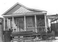
House on site affected by the construction of Interstate 26 (I-26). Address: 109½ Romney Street [109 Romney Street]. Surveyor notations on back of photo: "Dkt.: 10.503. Property owner: Mary C. Banks. Tract: 90. Station: 5917+70 Rt. Date: Feb. 20, 1963. In R/W - Bought." [See collection description for explanation of surveyor notations.]
House on site affected by the construction of Interstate 26 (I-26). Address: 109½ Romney Street [109 Romney Street]. Surveyor notations on back of photo: "Dkt.: 10.503. Property owner: Mary C. Banks. Tract: 90. Station: 5917+70 Rt. Date: Feb. 20, 1963. In R/W - Bought." [See collection description for explanation of surveyor notations.]
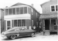
House (rear view) on site affected by the construction of the Crosstown. Address: 74 Cooper Street. Surveyor notations on back of photo: "Dkt.: 10.518. Property owner: Victoria Jenkins, Est. Tract: 21. Station: 40+30 Rt. N.B. lane Route 17. Date: Mar. 6, 1963." [See collection description for explanation of surveyor notations.]
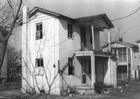
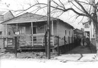
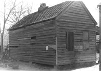
House in dilapidated condition on site affected by the construction of Interstate 26 (I-26). Address: 107 Romney Street. Surveyor notations on back of photo: "Dkt.: 10.503. Property owner: Louise W. Vaughan. Tract: 91. Station: 5916+90 on CL. Date: Feb. 20, 1963. In R/W - Bought." [See collection description for explanation of surveyor notations.]
House (freedman's cottage) in dilapidated condition (rear view) on site affected by the construction of Interstate 26 (I-26). Address: 107 Romney Street. Surveyor notations on back of photo: "Dkt.: 10.503. Property owner: Louise W. Vaughan. Tract: 91. Station: 5916+90 on CL. Date: Feb. 20, 1963. In R/W - Bought." [See collection description for explanation of surveyor notations.]
House (freedman's cottage) in dilapidated condition (rear view) on site affected by the construction of Interstate 26 (I-26). Address: 107½ Romney Street [107 Romney Street]. Surveyor notations on back of photo: "Dkt.: 10.503. Property owner: Louise W. Vaughan. Tract: 91. Station: 5916+40 on CL. Date: Feb. 20, 1963. In R/W - Bought." [See collection description for explanation of surveyor notations.]
House (freedman's cottage) in dilapidated condition on site affected by the construction of Interstate 26 (I-26). Address 107½ Romney Street [107 Romney Street]. Surveyor notations on back of photo: "Dkt.: 10.503. Property owner: Louise W. Vaughan. Tract: 91. Station: 5916+40 on CL. Date: Feb. 20, 1963. In R/W - Bought." [See collection description for explanation of surveyor notations.]
House (freedman's cottage) in dilapidated condition (side view) on site affected by the construction of Interstate 26 (I-26). Address: 107? Romney Street [107 Romney Street]. Surveyor notations on back of photo: "Dkt.: 10.503. Property owner: Louise W. Vaughan. Tract: 91. Station: 5916+35 Lt. Date: Feb. 20, 1963. In R/W - Bought." [See collection description for explanation of surveyor notations.]
House (freedman's cottage) in dilapidated condition on site affected by the construction of Interstate 26 (I-26). Address: 107? Romney Street [107 Romney Street]. Surveyor notations on back of photo: "Dkt.: 10.503. Property owner: Louise W. Vaughan. Tract: 91. Station: 5916+35 Lt. Date: Feb. 20, 1963. In R/W - Bought." [See collection description for explanation of surveyor notations.]
House (freedman's cottage) in dilapidated condition (side view) and outbuilding on site affected by the construction of Interstate 26 (I-26). Address: 103 Romney Street. Surveyor notations on back of photo: "Dkt.: 10.503. Property owner: Louise W. Vaughan. Tract: 91. Station: 5916+90 Lt. Date: Feb. 20, 1963. In R/W - Bought." [See collection description for explanation of surveyor notations.]
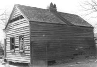
House (freedman's cottage) in dilapidated condition on site affected by the construction of Interstate 26 (I-26). Address: 103 Romney Street. Surveyor notations on back of photo: "Dkt.: 10.503. Property owner: Louise W. Vaughan. Tract: 91. Station: 5916+90 Lt. Date: Feb. 20, 1963. In R/W - Bought." [See collection description for explanation of surveyor notations.]
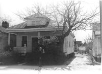
House on site affected by the construction of Interstate 26 (I-26). Address: 101 Romney Street. Surveyor notations on back of photo: "Dkt.: 10.503. Property owner: Arthur Rembert. Tract: 92. Station: 5916+90 Lt. Date: Feb. 20, 1963. In R/W - Bought." [See collection description for explanation of surveyor notations.]
House (rear view) on site affected by the construction of Interstate 26 (I-26). Address: 101 Romney Street. Surveyor notations on back of photo: "Dkt.: 10.503. Property owner: Arthur Rembert. Tract: 92. Station: 5916+90 Lt. Date: Feb. 20, 1963. In R/W - Bought." [See collection description for explanation of surveyor notations.]
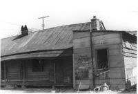
House (rear view) on site affected by the construction of the Crosstown. Address: 72 Cooper Street. Outhouse in foreground. Surveyor notations on back of photo: "Dkt.: 10.518. Property owner: Otis Williams. Tract: 22. Station: 40+55 Rt. N.B. lane Route 17. Date: Mar. 6, 1963." [See collection description for explanation of surveyor notations.]
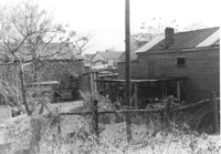
Lot on site affected by the construction of Interstate 26 (I-26). Address; 101 Romney Street. Surrounding houses and structures in background. Surveyor notations on back of photo: "Dkt.: 10.503. Property owner: Arthur Rembert. Tract: 92. Station: 5917+75 Lt. Date: Feb. 20, 1963. In R/W - Bought." [See collection description for explanation of surveyor notations.]
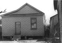
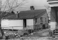
House (rear view) on site affected by the construction of Interstate 26 (I-26). Address: 99 Romney Street. Surveyor notations on back of photo: "Dkt.: 10.503. Property owner: Handy Felder, et al. Tract: 92-A. Station: 5916+95 Lt. Date: Feb. 20, 1963." [See collection description for explanation of surveyor notations.]
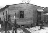
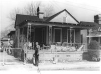
House on site affected by the construction of Interstate 26 (I-26). Address: 99 Romney Street. Surveyor notations on back of photo: "Dkt.: 10.503. Property owner: Handy Felder, et al. Tract: 92-A. Station: 5916+95 Lt. Date: Feb. 20, 1963." [See collection description for explanation of surveyor notations.]
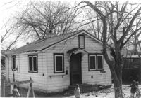
House on site affected by the construction of Interstate 26 (I-26). Address: 14 Addison Street. Surveyor notations on back of photo: "Dkt.: 10.503. Property owner: Eddie Jenkins, et al. Tract: 92-B. Station: 5918+70 Lt. Date: Feb. 20, 1963. In R/W - Bought." [See collection description for explanation of surveyor notations.]
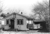
House (rear view) on site affected by the construction of Interstate 26 (I-26). Address: 14 Addison Street. Surveyor notations on back of photo: "Dkt.: 10.503. Property owner: Eddie Jenkins, et al. Tract: 92-B. Station: 5918+00 Lt. Date: Feb. 20, 1963. In R/W - Bought." [See collection description for explanation of surveyor notations.]