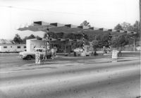
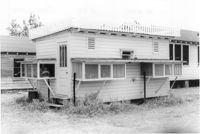
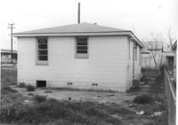
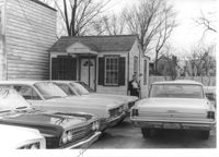
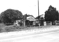
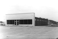
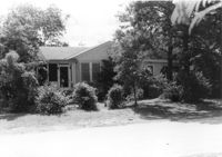
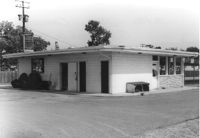
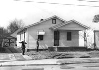
Kayo gas station, on site affected by the widening of State Road 13 (Remount Road). Surveyor notations on back of photo: "Dkt.: 10.562. Property owner: S.R. Hill - K.O. Station. Tract: 66. Date: Jul. 19, 1967." [See collection description for explanation of surveyor notations.]
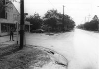
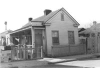
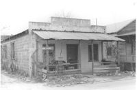
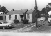
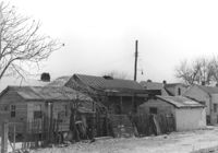
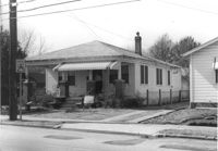
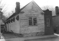
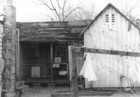
Bowers Hardware, on site affected by the widening of State Road 13 (Remount Road). Surveyor notations on back of photo: "Dkt.: 10.562. Property owner: J.R. Herrin. Tract: 82. Date: Jul. 19, 1967." [See collection description for explanation of surveyor notations.]
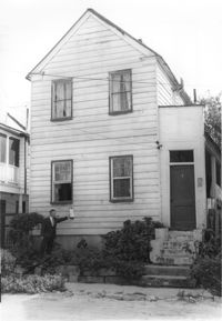
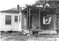
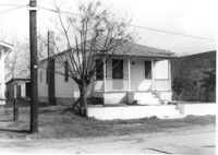
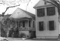
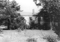
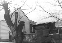
House (rear view) on site affected by the construction of the Crosstown. Address: 176 Nassau Street. Surveyor notations on back of photo: "Dkt.: 10.518. Property owner: Carole B. Priester. Tract: 32. Station: 42+35 Lt. N.B. lane Route 17. Date: Mar. 6, 1963. In R/W - Bought. [See collection description for explanation of surveyor notations.]
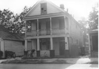
House on site affected by the construction of the Crosstown. Address: 147 President Street. Surveyor notations on back of photo: "Dkt.: 10.524. Property owner: Frank Chinners. Tract: 31. Station: 67+60 Rt. Date: Oct. 13, 1964. Partially In R/W - Bought." [See collection description for explanation of surveyor notations.]
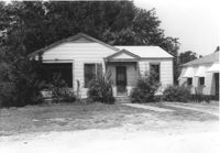
House on site affected by the construction of the Crosstown. Address: 9 Presidents Place. Surveyor notations on back of photo: "Dkt.: 10.524. Property owner: Mary Robinson, Est. Tract: 8. Station: 63+40 Rt. Date: Oct. 13, 1964. In R/W - Bought." [See collection description for explanation of surveyor notations.]
House on site affected by the construction of the Crosstown. Address: 9 Presidents Place. Surveyor notations on back of photo: "Dkt.: 10.524. Property owner: Mary Robinson, Est. Tract: 8. Station: 63+40 Rt. Date: Oct. 13, 1964. In R/W - Bought." [See collection description for explanation of surveyor notations.]
House on site affected by the construction of the Crosstown. Address: 11 Presidents Place. Surveyor notations on back of photo: "Dkt.: 10.524. Property owner: Lucille Smalls. Tract: 9. Station: 63+10 Rt. Date: Oct. 13, 1964. In R/W - Bought." [See collection description for explanation of surveyor notations.]
Structure and lot on site affected by the construction of the Crosstown. Address: 160 Cannon Street. Surveyor notations on back of photo: "Dkt.: 10.524. Property owner: Mabel M. Cecil McIherney. Tract: 7. Station: 62+75 CL Lt. Date: Oct. 13, 1964. Portion In R/W - Bought." [See collection description for explanation of surveyor notations.]
Outbuilding on site affected by the construction of Interstate 26 (I-26). Address: 2117 Weaver Avenue. See also I-26 Photos 1448-1449. Surveyor notations on back of photo: "Dkt.: 10.490. Property owner: Marion Butler, et al. Tract: 192. Station: 5888+80 Rt. Date: May 15, 1962. In R/W - Bought." [See collection description for explanation of surveyor notations.]
Bird house on site affected by the construction of Interstate 26 (I-26). Address: 2117 Weaver Avenue. See also I-26 Photos 1448-1449. Surveyor notations on back of photo: "Dkt.: 10.490. Property owner: Mrs. Lucretia Nowak. Tract: 191. Station: 5888+85 Lt. House, 5889+23 on CL Bird House. Date: May 15, 1962. In R/W - Bought." [See collection description for explanation of surveyor notations.]
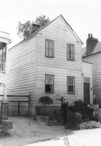
House (rear view) on site affected by the construction of the Crosstown. Address: 176 Nassau Street. Surveyor notations on back of photo: "Dkt.: 10.518. Property owner: Carole B. Priester. Tract: 32. Station: 42+05 Lt. N.B. lane Route 17. Date: Mar. 6, 1963. In R/W - Bought. [See collection description for explanation of surveyor notations.]
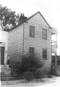
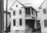
House (rear view) on site affected by the construction of the Crosstown. Address: 61 Lee Street. Surveyor notations on back of photo: "Dkt.: 10.518. Property owner: Sabrina Frost, Est. Tract: 39. Station: 44+00 CL S.B. lane Route 17. Date: Mar. 6, 1963. In R/W - Bought. [See collection description for explanation of surveyor notations.]
Structure (possibly a bird coop) on site affected by the construction of Interstate 26 (I-26). Address: 1338 Rutledge Avenue. Surveyor notations on back of photo: "Dkt.: 10.490. Property owner: Louise S. Carter. Tract: 157. Station: 5880+90 Lt. Date: May 15, 1962. In R/W - Bought." [See collection description for explanation of surveyor notations.]
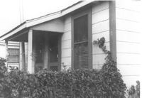
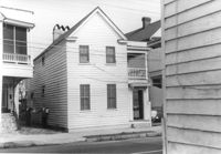
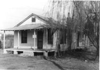
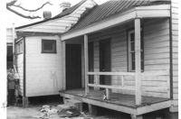
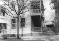
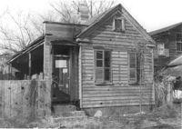
Freedman's cottage on site affected by the construction of the Crosstown. Address: 169 Nassau Street. Surveyor notations on back of photo: "Dkt.: 10.518. Property owner: R.F. Momier. Tract: 23. Station: 40+85 Rt. N.B. lane Route 17. Date: Mar. 6, 1963. In R/W - Bought. [See collection description for explanation of surveyor notations.]
House (rear view) on site affected by the construction of Interstate 26 (I-26). Address: 2129 Weaver Avenue. Surveyor notations on back of photo: "Dkt.: 10.490. Property owner: Lewis W. Infinger, Est. Tract: 197. Sta.: 110' Rt. Sta. 5889+25. Date: May 15, 1962. In R/W - Bought." [See collection description for explanation of surveyor notations.]
House on site affected by the widening of Route 171 (Folly Road). Surveyor notations on back of photo: "Dkt.: 10.494. Property owner: Sophie Sabel, Est. Tract: 97. Station: 372+20 Lt. Date: Mar. 21, 1962. To be cut off at R/W by SCHD [SC Highway Dept.?]. [See collection description for explanation of surveyor notations.]
"Junk lot" behind houses on site affected by the construction of the Crosstown. Address: 171 Nassau Street. Surveyor notations on back of photo: "Dkt.: 10.518. Property owner: Samuel J. Lloyd. Tract: 24. Station: 40+70 CL N.B. lane Route 17. Date: Mar. 6, 1963. In R/W - Bought. [See collection description for explanation of surveyor notations.]
Building (rear view), perhaps once used commercially (market?), on site affected by the construction of Interstate 26 (I-26). Side facade has stepped parapet. [Building address number 2212(?).] Surveyor notations on back of photo: "Dkt.: 10.490. Property owner: F.F. Bellinger. Tract: 88. Station: 5825+40 Rt. Date: March 22, 1962. In R/W - Bought." [See collection description for explanation of surveyor notations.]
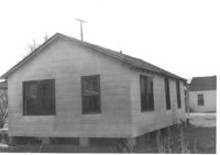
House (corner view, rear) on site affected by the construction of Interstate 26 (I-26). [Building address number 2220.] Surveyor notations on back of photo: "Dkt.: 10.490. Property owner: W.L. Gaillard, et al. Tract: 102. Station: 5827+85 Lt. Date: March 22, 1962. In R/W - Bought." [See collection description for explanation of surveyor notations.]
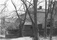
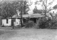
House and portion of lot, on site affected by the construction of Interstate 26 (I-26). View partially obscured by trees. Surveyor notations on back of photo: "Dkt.: 10.490. Property owner: Geo. L. Robertson [George L. Robertson]. Tract: 87. Station: 5824+80 Rt. Date: May 15, 1962. In R/W - Bought." [See collection description for explanation of surveyor notations.]
House (rear view) on site affected by the construction of Interstate 26 (I-26). [Building address number 2224.] Surveyor notations on back of photo: "Dkt.: 10.490. Property owner: Mary Jane Graham. Tract: 103-A. Station: 5827+90 Lt. Date: March 22, 1962. Owner to clear R/W." [See collection description for explanation of surveyor notations.]
House on site affected by the construction of Interstate 26 (I-26). Address: 2125 Weaver Avenue. Surveyor notations on back of photo: "Dkt.: 10.490. Property owner: Rob't O. Davey [Robert O. Davey]. Tract: 195. Station: 80' Rt. Sta. 5887+90. Date: May 15, 1962. In R/W - Bought." [See collection description for explanation of surveyor notations.]
House (corner view, rear) on site affected by the construction of Interstate 26 (I-26). Address: 1342 Rutledge Avenue. Surveyor notations on back of photo: "Dkt.: 10.490. Property owner: Louise S. Carter. Tract: 155. Station: 5880+40 Rt. Date: May 15, 1962. In R/W - Bought." [See collection description for explanation of surveyor notations.]
House on site affected by the construction of Interstate 26 (I-26). Address: 2129 Weaver Avenue. Surveyor notations on back of photo: "Dkt.: 10.490. Property owner: Lewis W. Infinger, Est. Tract: 197. Sta.: 110' Rt. Sta. 5889+25. Date: May 15, 1962. In R/W - Bought." [See collection description for explanation of surveyor notations.]
House (rear view) on site affected by the construction of Interstate 26 (I-26). Address: 2121 Weaver Avenue. Surveyor notations on back of photo: "Dkt.: 10.490. Property owner: Peter Putz. Tract: 193. Station: 5888+30 Rt. Date: May 15, 1962. In R/W - Bought." [See collection description for explanation of surveyor notations.]
Daniel Jenkins Homes, federal multi-family housing, on Richland Avenue (119 Richland Avenue and 120 Richland Avenue), on site affected by the construction of Interstate 26 (I-26). Surveyor notations on back of photo: "Dkt.: 10.490. Property owner: Ashley Development Co. Tract: 1-A. Station: 5783+10 to 5784+00 Lt. Date: September 11, 1962. To be cut off at R/W by owner." [See collection description for explanation of surveyor notations.]
Daniel Jenkins Homes, federal multi-family housing, on Richland Avenue (111 Richland Avenue and 112 Richland Avenue), on site affected by the construction of Interstate 26 (I-26). Surveyor notations on back of photo: "Dkt.: 10.490. Property owner: Ashley Development Co. Tract: 1-A. Station: 5788+35 to 5789+25 Rt. and Lt. Date: September 11, 1962. In R/W - Bought." [See collection description for explanation of surveyor notations.]
Lafayette Motors, on site affected by the construction of Interstate 26 (I-26). Address: 680 King Street. Surveyor notations on back of photo: "Dkt.: 10.517. Property owner: Raymond A. Wittschen. Tract: 122. Station: 28+35 Lt. Southbound Lane Route 17. Date: March 5, 1963. Proximity." [See collection description for explanation of surveyor notations.]
House on Coming Street near the corner of Sheppard Street, on site affected by the construction of Interstate 26 (I-26). Address: 278 Coming Street. Surveyor notations on back of photo: "Dkt.: 10.517. Property owner: Isaac Perry, et al. Tract: 99. Station: 22+00 Rt. Northbound Lane Route 17. Date: March 5, 1963. In R/W - Bought." [See collection description for explanation of surveyor notations.]
House on site affected by the construction of Interstate 26 (I-26). Address: 2123 Weaver Avenue. Surveyor notations on back of photo: "Dkt.: 10.490. Property owner: Henry Yaschik. Tract: 194. Station: 5888+10 Rt. Date: May 15, 1962. In R/W - Bought." [See collection description for explanation of surveyor notations.]
House on site affected by the construction of Interstate 26 (I-26). Surveyor notations on back of photo: "Dkt.: 10.490. Property owner: Theodore Nelson, et al. Tract: 111 and 112. Station: 5830+00 Rt. Date: August 29, 1962. In R/W - Bought." [See collection description for explanation of surveyor notations.]
House on site affected by the construction of Interstate 26 (I-26). Surveyor notations on back of photo: "Dkt.: 10.490. Property owner: W.L. Gaillard, et al. Tract: 100. Station: 5827+80 on CL. Date: March 22, 1962. In R/W - Bought." [See collection description for explanation of surveyor notations.]
House on site affected by the construction of Interstate 26 (I-26). Surveyor notations on back of photo: "Dkt.: 10.490. Property owner: W.L. Gaillard, et al. Tract: 98. Station: 5827+75 Rt. Date: March 22, 1962. In R/W - Bought." [See collection description for explanation of surveyor notations.]
House on site affected by the construction of Interstate 26 (I-26). Surveyor notations on back of photo: "Dkt.: 10.490. Property owner: W.L. Gaillard, et al. Tract: 99. Station: 5827+75 Rt. Date: March 22, 1962. In R/W - Bought." [See collection description for explanation of surveyor notations.]
House on site affected by the construction of Interstate 26 (I-26). Surveyor notations on back of photo: "Dkt.: 10.490. Property owner: Harold I. Sherman. Tract: 101. Station: 5827+80 Lt. Date: March 22, 1962. In R/W - Bought." [See collection description for explanation of surveyor notations.]
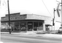
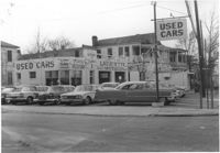
Lafayette Motors (Used Cars), on site affected by the construction of Interstate 26 (I-26). Address: 683 King Street. View of street corner (King Street and Fishburne Street. Surveyor notations on back of photo: "Dkt.: 10.517. Property owner: Hewitt Oil Co. Tract: 118. Station: 27+09 Lt. Southbound Lane Route 17. Date: March 5, 1963. Proximity." [See collection description for explanation of surveyor notations.]
Small office structure, with parked cars in foreground, on site affected by the construction of Interstate 26 (I-26). Address: 665 King Street. Surveyor notations on back of photo: "Dkt.: 10.517. Property owner: Palace Realty Co. Tract: 81. Station: 27±00 Rt. Northbound Lane Route 17. Date: March 5, 1963. In R/W - Bought." [See collection description for explanation of surveyor notations.]
Houses near the corner of Sheppard Street, on site affected by the construction of Interstate 26 (I-26). Addresses: 280 Coming Street (L) and 278 Coming Street (R). Surveyor notations on back of photo: "Dkt.: 10.517. Property owner: Jessica P. Brown. Tract: 98. Station: 22+00 Rt. Northbound Lane Route 17. Date: March 5, 1963. In R/W - Bought." [See collection description for explanation of surveyor notations.]
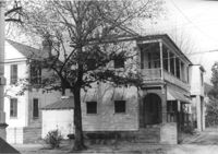
House (corner view, piazza side) on site affected by the construction of Interstate 26 (I-26). Address: 286 Coming Street. Surveyor notations on back of photo: "Dkt.: 10.517. Property owner: Wilhelmina J. Fields, Est. Tract: 104. Station: 22+60 Lt. Southbound Lane Route 17. Date: March 5, 1963. In R/W - Bought." [See collection description for explanation of surveyor notations.]
House, likely on Spruill Avenue, on site affected by the construction of Interstate 26 (I-26). Surveyor notations on back of photo: "Dkt.: 10.490. Property owner: Ernestine M. Taft. Tract: 3. Station: 47+00 (Spruill Ave.). Date: November 4, 1965. Range poles on new R/W. Proximity." [See collection description for explanation of surveyor notations.]
House on site affected by the construction of Interstate 26 (I-26). Building address number 2202. Surveyor notations on back of photo: "Dkt.: 10.490. Property owner: Julius A. Cercoply. Tract: 17. Station: 5818+20 Lt. Date: March 22, 1962. In R/W - Bought." [See collection description for explanation of surveyor notations.]
House (rear view) on site affected by the construction of Interstate 26 (I-26). Surveyor notations on back of photo: "Dkt.: 10.490. Property owner: Robert M. Huckabee. Tract: 14. Station: 5818+00 (Lt. Line "G"). Date: March 22, 1962. In R/W - Bought." [See collection description for explanation of surveyor notations.]
House on site affected by the construction of Interstate 26 (I-26). Surveyor notations on back of photo: "Dkt.: 10.490. Property owner: Robert M. Huckabee. Tract: 14. Station: 5818+00 (Lt. Line "G"). Date: March 22, 1962. In R/W - Bought." [See collection description for explanation of surveyor notations.]
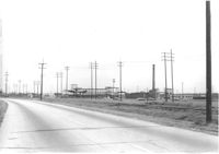
Road (presumably King Street Extn.) to Virginia-Carolina Chemical Corp. with its buildings in background, on site affected by the construction of Interstate 26 (I-26). Surveyor notations on back of photo: "Dkt.: 10.490. Property owner: V.C. Chemical Co. Tract: 1. Station: Panoramic view from North (see plans). Date: September 11, 1962. (For information.)" [See collection description for explanation of surveyor notations.]
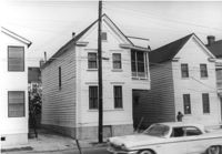
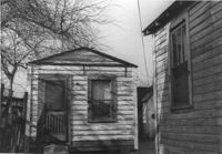
House (freedman's cottage) (rear view) on site affected by the construction of Interstate 26 (I-26). Address: 20 C Street. (1951 Sanborn map indicates the address is 14 C Street.) Surveyor notations on back of photo: "Dkt.: 10.517. Property owner: Edward Gallashaw, et al. Tract: 31. Station: 5948+50 Lt. - Line 6. Date: February 21, 1963. In R/W - Bought." [See collection description for explanation of surveyor notations.]
House in dilapidated condition (freedman's cottage?) on site affected by the construction of Interstate 26 (I-26). Address: 6 C Street. Number 14 painted on brick by front door. Surveyor notations on back of photo: "Dkt.: 10.517. Property owner: Mary Wayman. Tract: 30. Station: 5948+20 Lt. - Line 6. Date: February 21, 1963. In R/W - Bought." [See collection description for explanation of surveyor notations.]
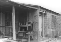
Structure in grassy lot, that looks like a dwelling but has Body Shop painted on side of building, on site affected by the construction of Interstate 26 (I-26). Address: 91 Lee Street (rear). Surveyor notations on back of photo: "Dkt.: 10.517. Property owner: W.H. Yon. Tract: 56. Station: 34+40 Rt. - Route 17. Date: February 21, 1963." [See collection description for explanation of surveyor notations.]
House (corner view, rear) on site affected by the construction of Interstate 26 (I-26). Address: 69 Fishburne Street. Surveyor notations on back of photo: "Dkt.: 10.517. Property owner: Ben F. Yancy, et al. Tract: 116. Station: 26+30 CL Southbound Lane Route 17. Date: March 5, 1963. In R/W - Bought." [See collection description for explanation of surveyor notations.]
House on site affected by the construction of Interstate 26 (I-26). Address: 85 Fishburne Street and its neighbor, 87 Fishburne Street. Surveyor notations on back of photo: "Dkt.: 10.517. Property owner: Thelma G. Carter. Tract: 107. Station: 23+30 Lt. Southbound Lane Route 17. Date: March 5, 1963. In R/W - Bought." [See collection description for explanation of surveyor notations.]
House near the corner of Sheppard Street, on site affected by the construction of Interstate 26 (I-26). Address: 280 Coming Street. Surveyor notations on back of photo: "Dkt.: 10.517. Property owner: Jessica P. Brown. Tract: 98. Station: 22+00 Rt. Northbound Lane Route 17. Date: March 5, 1963. In R/W - Bought." [See collection description for explanation of surveyor notations.]
House (rear view) on site affected by the construction of Interstate 26 (I-26). Address: 270 St. Philip Street. Surveyor notations on back of photo: "Dkt.: 10.517. Property owner: William H. Steedley. Tract: 114. Station: 25+40 Rt. Southbound Lane Route 17. Date: March 5, 1963. In R/W - Bought." [See collection description for explanation of surveyor notations.]
House on site affected by the construction of Interstate 26 (I-26). Address: 284 Coming Street. Surveyor notations on back of photo: "Dkt.: 10.517. Property owner: M.J. Christine Butt, Est. Tract: 103. Station: 22+40 Rt. Southbound Lane Route 17. Date: March 5, 1963. In R/W - Bought." [See collection description for explanation of surveyor notations.]
Dilapidated structure (possibly had commercial use) on site affected by the construction of Interstate 26 (I-26). Address: 3 C Street. "Saw Filing" sign posted on rail. Front facade has stepped parapet. Surveyor notations on back of photo: "Dkt.: 10.517. Property owner: J.W. Prescott. Tract: 43. Station: 5950+60 CL Line 2. Date: February 21, 1963. In R/W - Bought." [See collection description for explanation of surveyor notations.]
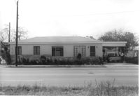
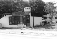
DuMont Television / Patterson's TV & Appliance Service Center / Karts Sales & Service on Dorchester Road, on site affected by the construction of Interstate 26 (I-26). Surveyor notations on back of photo: "Dkt.: 10.480. Property owner: Mrs. Margaret H. Patterson. Tract: 181. Station: 134+15 (Rt. (Route 642) [Dorchester Road]. Date: May 31, 1961. In R/W - Bought." [See collection description for explanation of surveyor notations.]
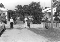
Driveway with low block walls on either side, on site affected by the construction of Interstate 26 (I-26). Two neighboring houses on either side in view. Surveyor notations on back of photo: "Dkt.: 10.480. Property owner: Mrs. Elena B. Pye. Tract: 186. Station: 5685+00 Rt. (Line D). Date: May 31, 1961. Block wall to be moved by SCHD." [See collection description for explanation of surveyor notations.]
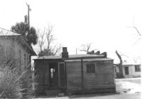
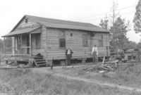
House and shed (rear view) on Dorchester Road, on site affected by the construction of Interstate 26 (I-26). Building address number 9. Surveyor notations on back of photo: "Dkt.: 10.480. Property owner: John H. Schulken, Est. Tract: 180. Station: 133+30 Rt. (Route 642) [Dorchester Road]. Date: May 31, 1961. In R/W - Bought." [See collection description for explanation of surveyor notations.]
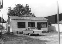
Pick & Pay Bicycle Repair Shop on site affected by the construction of Interstate 26 (I-26). Surveyor notations on back of photo: "Dkt.: 10.480. Property owner: G.S. Carter, Sr. Tract: 166. Station: 5681+50 Lt. Date: May 30, 1961. In R/W - Bought." [See collection description for explanation of surveyor notations.]
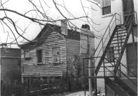
Dilapidated dwelling on site affected by the construction of Interstate 26 (I-26).Address: 6 D Street. Surveyor notations on back of photo: "Dkt.: 10.517. Property owner: Lawrence Felder, et al., Est. Tract: 15. Station: 5945+60 Lt. Date: February 21, 1963. In R/W - Bought." [See collection description for explanation of surveyor notations.]
House (rear view) on site affected by the construction of Interstate 26 (I-26). Address: 18 D Street. Surveyor notations on back of photo: "Dkt.: 10.517. Property owner: Annie Marie Brown. Tract: 7. Station: 5944+15 CL - Line 6. Date: February 21, 1963. In R/W - Bought." [See collection description for explanation of surveyor notations.]
Dwelling on site affected by the construction of Interstate 26 (I-26). Address: 3 C Street. Surveyor notations on back of photo: "Dkt.: 10.517. Property owner: J.W. Prescott. Tract: 43. Station: 5950+60 CL Line 2. Date: February 21, 1963. In R/W - Bought." [See collection description for explanation of surveyor notations.]
House on site affected by the construction of Interstate 26 (I-26). Address: 1 C Street. Surveyor notations on back of photo: "Dkt.: 10.517. Property owner: Ernie C. Swack. Tract: 44. Station: 5951+10 Lt. - Line 2. Date: February 21, 1963. In R/W - Bought." [See collection description for explanation of surveyor notations.]
Dilapidated structure (rear view) on site affected by the construction of Interstate 26 (I-26). Address: 3 C Street. Surveyor notations on back of photo: "Dkt.: 10.517. Property owner: J.W. Prescott. Tract: 43. Station: 5950+60 CL - Line 2. Date: February 21, 1963. In R/W - Bought." [See collection description for explanation of surveyor notations.]
House in dilapidated condition and sweetgrass basket stand on site affected by the widening of U.S. Route 17. Presumably located in Mount Pleasant or vicinity. Surveyor notations on back of photo: "Dkt.: 10.597. Property owner: Linda Huger, Estate. Tract: 84 & 85. Station: 448± Lt. Date: Sept. 17, 1968." [See collection description for explanation of surveyor notations.]
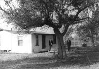
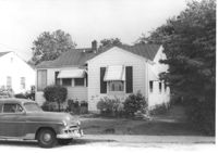
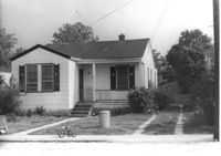
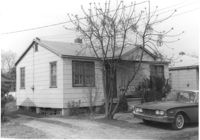
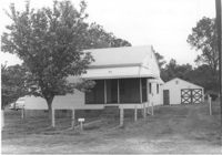
House on site affected by the construction of Interstate 26 (I-26). Driveway leads to garage/shed. Rooster and peacock in lot next door. Surveyor notations on back of photo: "Dkt.: 10.480. Property owner: Sadie B. Jones Franklin. Tract: 79. Station: 5519+40 Rt. Date: May 2, 1961. In R/W - Bought." [See collection description for explanation of surveyor notations.]
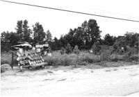
Lot with sweetgrass basket stand, on site affected by the widening of U.S. Route 17. Presumably located in Mount Pleasant or vicinity. Surveyor notations on back of photo: "Dkt.: 10.597. Property owner: Mary B. McConnell. Tract: 81. Station: 440±30 Rt. Date: Sept. 17, 1968." [See collection description for explanation of surveyor notations.]
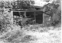
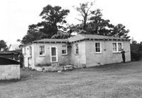
Health Club building and lot, on site affected by the construction of Interstate 26 (I-26). Nilson Storage Warehouse in background. Surveyor notations on back of photo: "Dkt.: 10.480. Property owner: G.S. Carter, Sr. Tract: 162. Station: 5677+60 Rt. Date: May 30, 1961. Damaged." [See collection description for explanation of surveyor notations.]
House (rear view) on site affected by the construction of Interstate 26 (I-26). Surveyor notations on back of photo: "Dkt.: 10.480. Property owner: Charlie C. Caldwell. Tract: 195. Station: 5688+50 Rt. Date: May 31, 1961. In R/W - Bought." [See collection description for explanation of surveyor notations.]
House (rear view) on site affected by the construction of Interstate 26 (I-26). Surveyor notations on back of photo: "Dkt.: 10.480. Property owner: Fritz E. Young. Tract: 232. Station: 5697+30 Lt. Date: May 31, 1961. Proximity to rear." [See collection description for explanation of surveyor notations.]
House on site affected by the construction of Interstate 26 (I-26). Surveyor notations on back of photo: "Dkt.: 10.480. Property owner: Jacob L. Nunnamaker. Tract: 234. Station: 5698+50 Lt. Date: May 31, 1961. Proximity to rear." [See collection description for explanation of surveyor notations.]
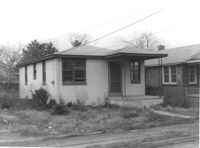
House on site affected by the construction of Interstate 26 (I-26). Surveyor notations on back of photo: "Dkt.: 10.480. Property owner: Charlie C. Caldwell. Tract: 195. Station: 5688+50 Rt. Date: May 31, 1961. In R/W - Bought." [See collection description for explanation of surveyor notations.]
House on site affected by the construction of Interstate 26 (I-26). Surveyor notations on back of photo: "Dkt.: 10.480. Property owner: Narvie L. Bilbray. Tract: 197. Station: 5688+40 Lt. Date: May 31, 1961. In R/W - Bought." [See collection description for explanation of surveyor notations.]
House in dilapidated condition (freedman's cottage) on site affected by the construction of Interstate 26 (I-26). Address: 22 Poinsett Street. Surveyor notations on back of photo: "Dkt.: 10.503. Property owner: Emma J. Marjen Hoff, Est. Tract: 103. Station: 5921+70 CL. Date: Feb. 20, 1963. In R/W - Bought." [See collection description for explanation of surveyor notations.]
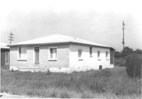
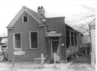
Free Kindergarten (corner view, rear) on site affected by the construction of Interstate 26 (I-26). Address: 20 Huger Street. Surveyor notations on back of photo: "Dkt.: 10.503. Property owner: Free Kindergarten Assoc. of Chas. Tract: 113. Station: 5936+50 Rt. CL. Date: Feb. 20, 1963. In R/W - Bought." [See collection description for explanation of surveyor notations.]
Lot (and rear view of neighboring houses and structures) on site affected by the construction of Interstate 26 (I-26). Address: 26 Addison Street. Surveyor notations on back of photo: "Dkt.: 10.503. Property owner: Alice Campbell Johnson. Tract: 96. Station: 5919+00 Rt. Date: Feb. 20, 1963. In R/W - Bought." [See collection description for explanation of surveyor notations.]
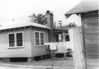
House (freedman's cottage) and shed (rear view) on site affected by the construction of Interstate 26 (I-26). Address: 24 Addison Street. Surveyor notations on back of photo: "Dkt.: 10.503. Property owner: Beatrice Scott. Tract: 93. Station: 5918+80 CL. Date: Feb. 20, 1963. In R/W - Bought." [See collection description for explanation of surveyor notations.]
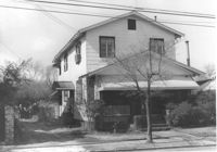
House, possibly duplex (side view, rear), and outbuilding, on site affected by the construction of Interstate 26 (I-26). Surveyor notations on back of photo: "Dkt.: 10.480. Property owner: Roy A. Farley, et al. Tract: 102-A. Station: 55+60 Lt. (Goodrich Road). Date: May 2, 1961. Proximity." [See collection description for explanation of surveyor notations.]
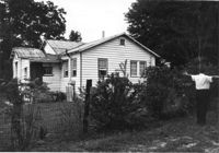
House on site affected by the construction of Interstate 26 (I-26). Outbuilding in background; lumber and other debris in yard. Surveyor notations on back of photo: "Dkt.: 10.480. Property owner: Sylvia Yaschik. Tract: 94. Station: 5523+60 Rt. Date: May 2, 1961. In R/W - Bought." [See collection description for explanation of surveyor notations.]
Rear (corner view) of building (a pizza restaurant), on site affected by the construction of Interstate 26 (I-26). Surveyor notations on back of photo: "Dkt.: 10.480. Property owner: G.S. Carter, Sr. Tract: 162. Station: 5679+50 Rt. Date: May 30, 1961. In R/W - Bought." [See collection description for explanation of surveyor notations.]
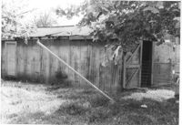
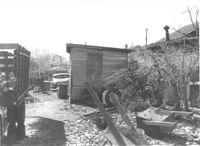
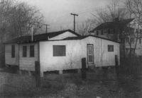
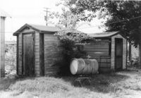
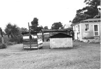
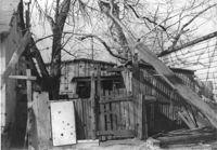
Sheds on site affected by the construction of Interstate 26 (I-26). Surveyor notations on back of photo: "Dkt.: 10.480. Property owner: Arlene Phillips, Est. Tract: 165. Station: 5681+10 Lt. Date: May 30, 1961. In R/W - Bought." [See collection description for explanation of surveyor notations.]
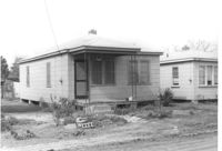
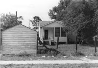
House on site affected by the construction of Interstate 26 (I-26). Driveway leads to garage/shed. Surveyor notations on back of photo: "Dkt.: 10.480. Property owner: O.C. House, et al. Tract: 129. Station: 5651+25 Rt. Date: May 1, 1961. In R/W - Bought." [See collection description for explanation of surveyor notations.]
House (freedman's cottage) on site affected by the construction of Interstate 26 (I-26). Address: 7 Brigade Street. Surveyor notations on back of photo: "Dkt.: 10.503. Property owner: Idella C. Calvin. Tract: 45. Station: 5905+20 Lt. Date: Feb. 19, 1963. In R/W - Bought." [See collection description for explanation of surveyor notations.]
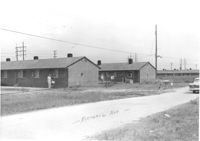
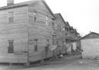
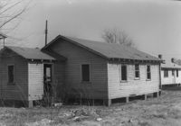
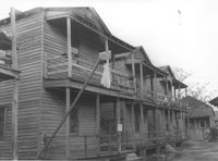
Row of houses (rear view) on site affected by the construction of Interstate 26 (I-26). Address: 16-18 J Place [between Lenox and Brigade]. (See Sheet 1 of 1951 Sanborn Map.) Surveyor notations on back of photo: "Dkt.: 10.503. Property owner: Gussie Feldman. Tract: 41. Station: 5903+50 Rt. & Lt. In R/W - Bought." [See collection description for explanation of surveyor notations.]
Row of houses on Brigade Street, on site affected by the construction of Interstate 26 (I-26). Address: 10-18 J Place [between Lenox and Brigade]. (See Sheet 1 of 1951 Sanborn Map.) Surveyor notations on back of photo: "Dkt.: 10.503. Property owner: Gussie Feldman. Tract: 41. Station: 5903+50 Rt. & Lt. In R/W - Bought." [See collection description for explanation of surveyor notations.]
House in dilapidated condition on site affected by the construction of Interstate 26 (I-26). Outbuilding/shed in background. Surveyor notations on back of photo: "Dkt.: 10.480. Property owner: Laurence Pinckney, et al. Tract: 74. Station: 5520+80 Lt. Date: May 2, 1961. In R/W - Bought." [See collection description for explanation of surveyor notations.]
House (rear view) on site by the construction of Interstate 26 (I-26). Address: 1211 King Street. Surveyor notations on back of photo: "Dkt.: 10.503. Property owner: Albert M. Jones, et al. Tract: 17. Station: 5895+00 Lt. Date: Feb. 19, 1963. In R/W - Bought." [See collection description for explanation of surveyor notations.]
House on site by the construction of Interstate 26 (I-26). Address: 1213 King Street. Surveyor notations on back of photo: "Dkt.: 10.503. Property owner: Robert C. Benke, et al. Tract: 16. Station: 5894+90 Lt. Date: Feb. 19, 1963. In R/W - Bought." [See collection description for explanation of surveyor notations.]
House on site by the construction of Interstate 26 (I-26). Address: 1211 King Street. Surveyor notations on back of photo: "Dkt.: 10.503. Property owner: Albert M. Jones, et al. Tract: 17. Station: 5895+00 Lt. Date: Feb. 19, 1963. In R/W - Bought." [See collection description for explanation of surveyor notations.]
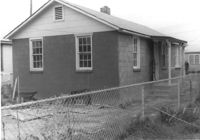
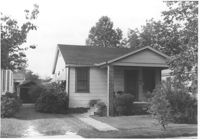
House on site by the construction of Interstate 26 (I-26). Address: 1201 King Street. Surveyor notations on back of photo: "Dkt.: 10.503. Property owner: Gladys Hardy. Tract: 18. Station: 5895+65 Rt. Date: Feb. 19, 1963. In R/W - Bought." [See collection description for explanation of surveyor notations.]
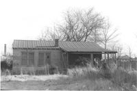
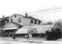
Greenhouse-like structure (plant nursery) on site by the construction of Interstate 26 (I-26). Address: 1205 King Street. Surveyor notations on back of photo: "Dkt.: 10.503. Property owner: Gladys Hardy. Tract: 18. Station: 5895+50 on CL. Date: Feb. 19, 1963. In R/W - Bought." [See collection description for explanation of surveyor notations.]
House on site affected by the construction of the Crosstown. Address: 161 Line Street. (Possibly a freedman's cottage with altered entry and porch.) Surveyor notations on back of photo: "Dkt.: 10.524. Property owner: Christopher C. Polite, Est. Tract; 94. Station: 81+90 CL. Date: Dec. 1, 1964. In R/W - Bought." [See collection description for explanation of surveyor notations.]
Rear view of house and sheds on site affected by the widening of U.S. Route 17. Presumably located in Mount Pleasant or vicinity. Surveyor notations on back of photo: "Dkt.: 10.597. Property owner: John Gailliard. Tract: 102. Station: 466±40 Rt. Date: Sept. 17, 1968." [See collection description for explanation of surveyor notations.]
House (corner view, rear) on site affected by the widening of U.S. Route 17. Presumably located in Mount Pleasant or vicinity. Surveyor notations on back of photo: "Dkt.: 10.597. Property owner: John Gailliard. Tract: 102. Station: 466±40 Rt. Date: Sept. 17, 1968." [See collection description for explanation of surveyor notations.]
House (corner view, rear) on site affected by the widening of U.S. Route 17. Presumably located in Mount Pleasant or vicinity. Surveyor notations on back of photo: "Dkt.: 10.597. Property owner: Charles Dingle. Tract: 98. Station 462±50 Rt. Date: Sept. 17, 1968." [See collection description for explanation of surveyor notations.]
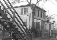
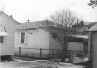
House (rear view) on site affected by the construction of Interstate 26 (I-26). Address: 14 Wood Street. Surveyor notations on back of photo: "Dkt.: 10.503. Property owner: Walter K. Brown. Tract: 32. Station: 5900+10 Lt. Date: Feb. 19, 1963. In R/W - Bought." [See collection description for explanation of surveyor notations.]
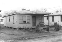
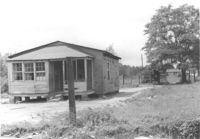
Small dwelling on site affected by the construction of Interstate 26 (I-26). Address: 20½ Poinsett Street. Surveyor notations on back of photo: "Dkt.: 10.503. Property owner: B.W. Donnell, Est. Tract: 101. Station: 5921+00 Lt. Date: Feb. 20, 1963. In R/W - Bought." [See collection description for explanation of surveyor notations.]
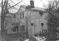
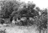
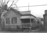
House in dilapidated condition on site affected by the construction of Interstate 26 (I-26). Surveyor notations on back of photo: "Dkt.: 10.480. Property owner: Virginia S. Green. Tract: 37. Station: 5508+00 CL. Date: May 2, 1961. In R/W - Bought." [See collection description for explanation of surveyor notations.]
Dilapidated structure on site affected by the construction of Interstate 26 (I-26). Address: 22½ Poinsett Street (rear). Surveyor notations on back of photo: "Dkt.: 10.503. Property owner: J.W. Blanchard, Est. Tract: 102. Station: 5921+00 Lt. Date: Feb. 20, 1963. In R/W - Bought." [See collection description for explanation of surveyor notations.]
Structures on site affected by the construction of Interstate 26 (I-26). Address: 20? Poinsett Street. Surveyor notations on back of photo: "Dkt.: 10.503. Property owner: B.W. Donnell, Est. Tract: 101. Station: 5921+00 Lt. Date: Feb. 20, 1963. In R/W - Bought." [See collection description for explanation of surveyor notations.]
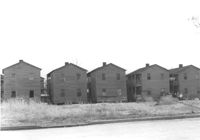
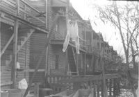
Row of houses on site affected by the construction of Interstate 26 (I-26). Address: 10-14 J Place [between Lenox and Brigade]. (See Sheet 1 of 1951 Sanborn Map.) Surveyor notations on back of photo: "Dkt.: 10.503. Property owner: Gussie Feldman. Tract: 41. Station: 5903+50 Rt. & Lt. In R/W - Bought." [See collection description for explanation of surveyor notations.]
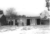
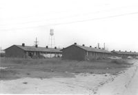
Row of houses (rear view) on site affected by the construction of Interstate 26 (I-26). Address: 20-32 Brigade Street. Surveyor notations on back of photo: "Dkt.: 10.503. Property owner: Gussie Feldman. Tract: 41. Station: 5904±20 Rt. & Lt. Date: Feb. 19, 1963. In R/W - Bought. (Rear of buildings fronting Brigade Street.)" [See collection description for explanation of surveyor notations.]
Limit your search
SCDOT Photographs: Properties in the Right-of-Way✖[remove]2,276