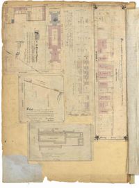
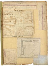
Page 92 of the City Engineer's Plat Book with six plats. Plat 1 features a "Plan of the Citadel Square," located between King Street and Meeting Street, and between Calhoun Street and Hudson Street. Plat 1 also shows several buildings, including the Citadel, the "U.S. Gov. Stables," and the "U.S. Hospital." Plat 2 shows lots and several buildings located between Smith Street and Franklin Street. Plat 3 shows lots and structures located along Market Street, between Church Street and Meeting Street. Plat 4 shows lots and structures located near Calhoun Street. Plat 5 shows several lots and structures located on King Street. Plat 6 is affixed to the page so it folds out, and shows lots located near Spring Street, between Chesnut Street and President Street. Plat 6 also shows Pine Street, Cannons Court, and Bee Street.
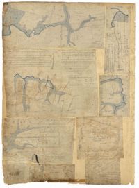
Page 88 of the City Engineer's Plat Book with eight plats. Plat 1 shows a stream and marshland starting at the Ashley River. Plat 2 features land located near the Ashley River and Grove Street. It also features several structures, some marshland, and a creek. Plat 3 shows land located near Grove Street, including some structures, some marshland, and a stream. Plat 4 shows land located Grove Street, including some buildings, a creek, and marshland. Plat 5 shows lots located between a stretch of marsh and Rutledge Avenue. Plat 5 also shows Congress Street, Legare Street, Huger Street, Moultrie Street, and a race track. Plat 6 features Washington Race Course, located between Grove Street and Moultrie Street, and between Congress Street and an unlabeled Street. Plat 7 shows "34 acres of Marsh" located between the Ashley River and a public cemetery. Plat 8 shows marshland located on the Ashley River, near "new Spring Street" and a creek.
Page 86 of the City Engineer's Plat Book with four plats. Plat 1 shows land starting west of Legare Street and ending east of America Street. Plat 1 also includes Line Street, Pinckney Street, King Street, Meeting Street, America Street, a public square, and several marshes. Plat 2 shows a stretch of land starting west of Legare Street and ending at Drake Street. Plat 2 also shows Line Street, Sheppard Street, Coming Street, St. Phillips Street, King Street, Meeting Street, America Street, a lot labelled "Est of Nells Rope yard," and several marshes. Plat 3 shows 3 plots of land near a road, a marsh, and a pond. Plat 4 shows land near King Street, where it intersects with Huger Street and Charlotte Street.
Page 90 of the City Engineer's Plat Book with four plats. Plat 1 shows lots located between King Street and Russell Street, near Grove Street and Poinsett Street. Plat 2 shows lots located between Meeting Street and King Street, with a strip of land labelled "S.C.R.R.," a common acronym for the South Carolina Rail Road. Plat 3 features lots located near Boigard Street. Plat 4 features land located on the Ashley River, near Grove Street, shows a stream and several structures.
Page 91 of the City Engineer's Plat Book with five plats. Plat 1 shows lots located near Guinard Street. Plat 2 shows lots located between Nassau Street and Meeting Street, and between Johnson Street and Stuart Street. Plat 3 shows lots located along East Bay Street, between Guignard Street and Pinckney Street. Plat 4 features a lot and several structures located near the intersection of Logan Street and Broad Street. Plat 5 features a lot located near the intersection of Broad Street and Rose Lane.
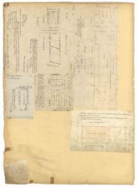
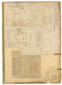
Page 93 of the City Engineer's Plat Book with two plats. Plat 1 features the "U.S. Custom-House Premises," located between East Bay Street and the Cooper River, and Market Street and Gaillard Street. Plat 1 also shows several structures. Plat 2 features a lot near "Smith's Place" and a creek, and shows several structures, including one labelled "Saw and Planning Mill" and another labelled "Engine Boiler room."
Page 98 of the City Engineer's Plat Book with three plats. Plat 1 shows lots between King Street and Meeting Street, including a stretch of railroad track and some marshlands. Plat 2 shows lots located near Rutledge Avenue. Plat 3 shows land located near a public road, showing a creek labelled "into Ashley," and stretches of marshland.
Page 21 of the City Engineer's Plat Book with six plats. Plat 1 shows land between Broad Street and Tradd Street, and Logan Street and New Street, including a sizable portion labelled "Middletons Lots." Plat 2 shows a lot on Broad Street and its buildings. Plat 3 shows lots located near Rutledge Street, Queen Street, Beaufain Street, and Smith Street, and some "City marshlands." Plat 4 shows plots located near Rutledge Street, Beaufain Street, Queen Street, and Smith Street. Plat 5 shows a lot and buildings located near the intersection of Queen Street and Mazyck Street. Plat 6 shows lots of land located on King Street, including one labelled "Unitarian Church."
Page 22 of the City Engineer's Plat Book with five plats. Plat 1 shows lots located near the Charleston Harbor, Concord Street, Pinckney Street, and Pritchard Street. Plat 2 shows lots and structures located near the intersection of Concord Street and Pinckney Street, including a single-story building, a wharf, and a label reading "City property leased." Plat 3 shows a lot on Broad Street labelled "Lot of David McCredie." Plat 4 Shows lots located near Park Street, and between Shepherd Street and Line Street. Plat 5 shows lots near the intersection of Broad Street and Gadsden's Alley labelled with the names of banks.
Page 19 of the City Engineer's Plat Book with six plats. Plat 1 shows lots and buildings located near the intersection of Pitt Street and Bull Street. Plat 2 shows lots and buildings located near the intersection of Meeting Street and Reid Street. Plat 3 shows lots between King Street and Congress Street, also located near Grove Street and Moultrie Street. Plat 4 shows a lot on Amen Street labelled "Thomas N. Gadsen Esq." and noting multiple brick buildings. Plat 5 shows lots located on Cumberland Street. Plat 6 shows lots located on Amen Street and two two-story brick buildings.