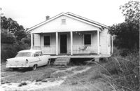
House on site affected by the construction of Interstate 26 (I-26). Sign posted in ground: Worms for sale. Surveyor notations on back of photo: "Dkt.: 10.471. Property owner: F.R. Shutt, et al. Tract: 92. Station: 5376+10 Rt. Date: Aug. 23, 1960. In R/W - Bought." [See collection description for explanation of surveyor notations.]
House on site affected by the construction of Interstate 26 (I-26). Surveyor notations on back of photo: "Dkt.: 10.471. Property owner: W.L. McDonald, et al. Tract: 38. Station: 5326+00 Rt. Date: Aug. 23, 1960. In R/W - Bought." [See collection description for explanation of surveyor notations.]
House on site affected by the construction of Interstate 26 (I-26). Surveyor notations on back of photo: "Dkt.: 10.471. Property owner: Isabella W. Meany. Tract: 98. Station: 5378+80 Rt. Date: Aug. 23, 1960. In R/W - Bought." [See collection description for explanation of surveyor notations.]
House on site affected by the construction of Interstate 26 (I-26). Surveyor notations on back of photo: "Dkt.: 10.471. Property owner: Annie L. Beattie. Tract: 83. Station: 5364+00 Rt. Date: Aug. 23, 1960. In R/W - Bought." [See collection description for explanation of surveyor notations.]
House on site affected by the construction of Interstate 26 (I-26). Surveyor notations on back of photo: "Dkt.: 10.471. Property owner: E.T. Walling. Tract: 39. Station: 5324+30 Lt. Date: Aug. 23, 1960. In R/W - Bought." [See collection description for explanation of surveyor notations.]
House on site affected by the construction of Interstate 26 (I-26). Surveyor notations on back of photo: "Dkt.: 10.471. Property owner: J.E. Walling. Tract: 41. Station: 5325+15 Rt. Date: Aug. 23, 1960. In R/W - Bought." [See collection description for explanation of surveyor notations.]
House on site affected by the construction of Interstate 26 (I-26). Surveyor notations on back of photo: "Dkt.: 10.471. Property owner: R.B. Evans. Tract: 2. Station: 5155+75 Lt. Date: Aug. 23, 1960. Proximity." [See collection description for explanation of surveyor notations.]
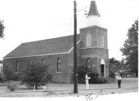
Mid Park Methodist Church, on site affected by the construction of Interstate 26 (I-26). Surveyor notations on back of photo: "Dkt.: 10.471. Property owner: Mid Park Meth. Church. Tract: 102. Station: 5376+50 Rt. Date: Aug. 23, 1960. Proximity." [See collection description for explanation of surveyor notations.]
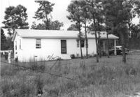
House on site affected by the construction of Interstate 26 (I-26). Building address number 22 (painted on mailbox). Surveyor notations on back of photo: "Dkt.: 10.471. Property owner: Eleanor L. O'Brien. Tract: 105. Station: 5379+50 Lt. Date: Aug. 23, 1960. Proximity." [See collection description for explanation of surveyor notations.]
House, and Fuller's Grocery, on site affected by the construction of Interstate 26 (I-26). Surveyor notations on back of photo: "Dkt.: 10.471. Property owner: H.L. Fuller. Tract: 103. Station: 28+00 Lt. (Midland Park Road). Date: Aug. 23, 1960. Proximity." [See collection description for explanation of surveyor notations.]
Limit your search
SCDOT Photographs: Properties in the Right-of-Way✖[remove]79