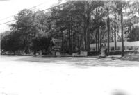
Mt. Pleasant Motel, on site affected by the widening of U.S. Route 17. Presumably located in Mount Pleasant or vicinity. Surveyor notations on back of photo: "Dkt.: 10.439. Property owner: George A. Kaiser, et al. Tract: 16. Station: 225+51 to 228+52 Lt. Date: Jul. 22, 1965. From across road showing brick columns on 33' R/W & range poles on 50' R/W - Cond." [See collection description for explanation of surveyor notations.]
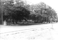
Mt. Pleasant Motel, on site affected by the widening of U.S. Route 17. Presumably located in Mount Pleasant or vicinity. Surveyor notations on back of photo: "Dkt.: 10.439. Property owner: George A. Kaiser, et al. Tract: 16. Station: 228+52 Lt. Date: Jul. 22, 1965. Taken from east side with brick columns on 33' R/W & range poles on 50' R/W - Cond." [See collection description for explanation of surveyor notations.]
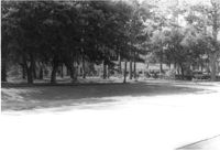
Mt. Pleasant Motel, on site affected by the widening of U.S. Route 17. Presumably located in Mount Pleasant or vicinity. Surveyor notations on back of photo: "Dkt.: 10.439. Property owner: George A. Kaiser, et al. Tract: 16. Station: 225+51 to 228+52 Lt. Date: Jul. 22, 1965. Looking from across road at range poles on 50' R/W." [See collection description for explanation of surveyor notations.]
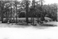
Mt. Pleasant Motel, on site affected by the widening of U.S. Route 17. Presumably located in Mount Pleasant or vicinity. Surveyor notations on back of photo: "Dkt.: 10.439. Property owner: George A. Kaiser, et al. Tract: 16. Station: 225+51 to 228+52 Lt. Date: Jul. 22, 1965. Range poles on 50' R/W. Face of brick columns on 33' R/W - Cond." [See collection description for explanation of surveyor notations.]
Right of way--South Carolina--Charleston County, Highway planning--South Carolina--Charleston County, Commercial buildings--South Carolina--Charleston County, Vernacular architecture--South Carolina--Charleston County, Lost architecture--South Carolina--Charleston County, Motels--South Carolina--Charleston County✖[remove]4