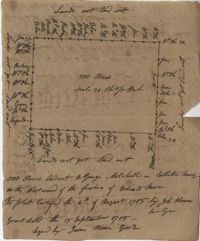
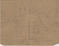
876 acres of land west of Murray Road in St. John's Parish. Names associated with this plat are Chas Johnston, Ben Castell, William Simpson, Verth, and J.G. Wiare. Notable geographic locations include Wadboo Barony.
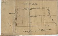
Plat of 500 acres belonging to George Mitchell in Colleton County near the Edisto River. Includes the outline of the property and the location of trees on the property line. Names associated with this plat are George Mitchell, Job Howe, and James Moore. Notable geographic locations include the Edisto River, Colleton County and St. Bartholomew's Parish.
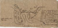
Copy of a tract of 127 acres in the marsh on the Ashepoo River belonging to Sarah McPherson. Little detail included in the plat. Names associated with this plat are Sarah McPherson, Willliam Spense, and Joshua McPherson. Notable geographic locations are the Ashepoo River, Deer Creek, Ladson, and Colleton County.
Copy of a plan of 195 acres of land near the Cooper River including dams, a house, marsh and saw pit. Names associated with this plat include Mary Rupell, Robertson, Atkin, Dr. Brabangs, Withers, Jenson, Lanue and G. Arch.
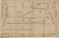
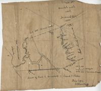
1100 acres of land belonging to Thomas Woodward on the east and west side of Fish Pond Creek known as Ashepoo River. Names associated with this plat are Thomas Woodward, Elizabeth Woodward, James St. John, Billinger, and Blaky, and William. Notable geographic locations include Ashepoo River and Fish Pond Creek.
Office copy of a tract of land once belonging to Thomas Nau then John S. Cripps containing 277 1/2 acres. The land includes gum, white and red oak, and cedar trees along with posts, a rice field and a bridge over the public road from Rantoles [Rantowles] to Charleston. Names associated with this plat include John S. Cripps, Thomas Nau, and S. Lewis.
25 acres of land containing two dams, a reserve, and pine and oak trees owned by George Holmes near 7 mile south of lands owned by J. Meetze. Names associated with this plat include George Holmes, J. Meetze and Simons.
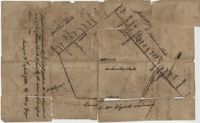
Copy of a plat of 355 Acres of land in Berkeley County near the West side of Cooper River, shows surrounding properties, doesn’t include land type or detailed notations. Names associated with this plat are Edward Keating, William Kimlough, Buvet, Matthew Beard, Colonel Chicken, Chapennoun Elliott, Robert Daniell, Longrove Thomas, Edward Keyting, Andrew Allens, William Gibbons, James Kenloch, William Adams, Allen Anderson, William Gibbons, Matthew Benson, Thomas Smith, John Vecandge [?], Francis Ternandol, and Allen Andrew. Notable geographic locations include St. James Parish, Goose Creek, Cooper River, and Berkeley County.
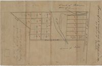
Plat of 19 acres in St. Andrew’s Parish. A corn field is noted as is a public road along with the neighboring property owners. Little other detail. Names associated with this plat are James C. Perry, Cook, Sault, Benjamin, F.R.N. [?] Smith, Dinzhals [?], S. Charles, and Cattell.
Small description of a 264 acre land, near Wappoo Creek, including land description. Names associated with this plat are John Schnerlie, Thomas S. Jones, and Edwin R. Dorrill. Notable geographic locations include the Ashley River, Wappoo Creek, Ashley Bridge Ferry Road, and Charleston District.