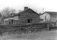
House (freedman's cottage) on site affected by the construction of the Crosstown. Address: 28 Lee Street (28 1/3 Lee Street). Billboard from Photo 127 in background. Surveyor notations on back of photo: "Dkt.: 10.518. Property owner: Sara Johnson, et al. Tract: 81. Station: 53+45 Rt. N.B. lane Route 17. Date: Mar. 7, 1963." [See collection description for explanation of surveyor notations.]
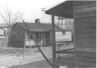
House (freedman's cottage) on site affected by the construction of the Crosstown. Address: 28 Lee Street (28 1/3 Lee Street). Porch of neighboring house in foreground. Surveyor notations on back of photo: "Dkt.: 10.518. Property owner: Sara Johnson, et al. Tract: 81. Station: 53+45 Rt. N.B. lane Route 17. Date: Mar. 7, 1963." [See collection description for explanation of surveyor notations.]
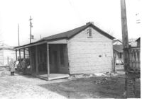
House (freedman's cottage) on site affected by the construction of the Crosstown. Address: 30 Cooper Street (30 1/3 Cooper Street). Surveyor notations on back of photo: "Dkt.: 10.518. Property owner: Edna C. Parham. Tract: 82. Station: 52+70 Rt. N.B. lane Route 17. Date: Mar. 7, 1963." [See collection description for explanation of surveyor notations.]
Right of way--South Carolina--Charleston County, Highway planning--South Carolina--Charleston County, Vernacular architecture--South Carolina--Charleston County, Lost architecture--South Carolina--Charleston County, Dwellings--South Carolina--Charleston County, African Americans--Housing✖[remove]53