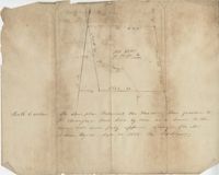
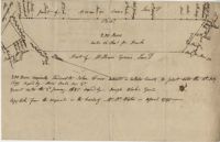
Sketch of the survey ad laying out of a small tract called Red Branch on the west side of the Cooper River containing 6 acres lately sold by Middleton to Leval part of 400 acres tract granted to Dr. Snow. Names associated with this plat are Peter Pamplat, Peter Gray, Snow, and Middleton.
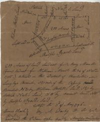
Plat includes Langley Branch Road going through plat as well as a road. Plat consists of 200 acres. Names associated with this plat are Mary Manlt, William Manlt, William Postell, Patrick Neel, Ralph Izard, Thomas Clark, A. Darby, Amoldus Vanderhorst, Margaret Manlt and W.S. Smith. Notable geographic locations include St. George’s Parish, Langley Branch, Cypress Road, Dorchester, Cypress Swamp, and Charleston District.
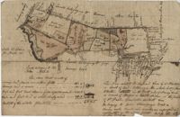
"A Plan of a Plantation or Tract of Land on Penny Creek a Branch of Ponpon or Edisto River late the property of Joseph Bee Esquire now belonging to John Champney Esquire." Plat contains 687 acres on the north side of Penny Creek the plat is divided by use of lands and the location of structures on the property. Names associated with this plat are John Champney, Dr. John Mitchell, Thomas Bee, Joseph Bee, and George Savage. Notable geographic locations include Penny Creek, Edisto River, Pon Pon River, Landing Road, and Bridge Road.
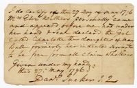
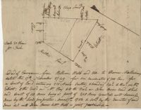
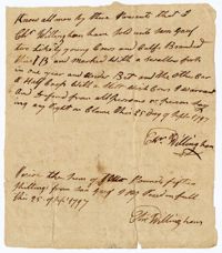
A legal claim written by Daniel Tucker for a woman named Mrs. Withers certifying that Charlotte, the daughter of Mary Ball, formerly her indentured servant, is free from all claims.
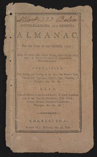
This is a Sandy Island plantation journal written inside of the South Carolina and Georgia Almanac for the year 1797. The plantation journal documents the planting of crops (rice, corn and potatoes), slave records (including runaway slaves), accounts, the weather, and business relations with Laurel Hill Plantation.
200 Acre plot of land laid out to John Freer, shows some creeks and trees, no land type or details. Names associated with this plat are John Freer, Stephen Bull, Joseph Blake, William Weston, William Green, and B. Sam. Notable geographic locations include Colleton County, Freer District, and Wadmalaw River.
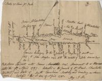
169 acre plot given to Kent McCall, shows roads and surrounding neighbors, shows the Ashley River and some trees on the property borders. Names associated with this plat are Kent McCall, Thomas Parker, Roger Smith, Burnard Elliott, Crughtton, William Elliott, John Heard, Benjamin Dart, Elizabeth McCall, John Ward, John Parker, and Thomas Parker. Notable geographic locations include St. Andrew's Parish and the Ashley River.
128 acres situated in the Charleston district unto James Maxwell situated in the parish of St. Paul, Charleston District April 1, 1797. Names associated with this plat include James Maxwell, Jane Ladson, Smith, John Boyles, John Somers and Brigdon Smith. Notable geographic locations include St. Paul's Parish, Jerico Plantation, Bretton Hall Plantation, Bay Swamp, and Charleston District.
Copy of tract of land containing 200 acres, butting and bounding south and west by William Elliott, and on the east by Clay, and to the north by John Rivers. Names associated with this plat include William Webb, Thomas Mellichamp, Butler, William Elliott, William Clay, Shem, John Rivers, John S. Cripps, Samuel Jones, the Lords Proprietors, and Daniel Gibson.