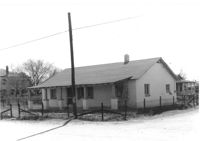
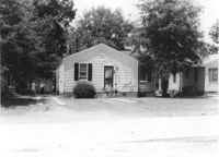
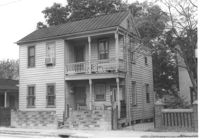
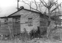
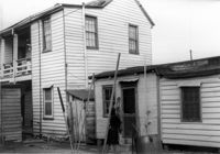
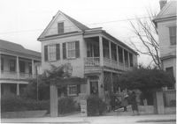
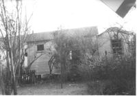
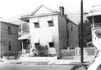
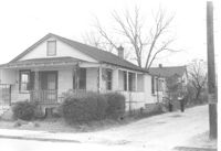
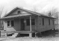
House on site affected by the construction of Interstate 26 (I-26). [Address 2207 Peace.] View of street corner. Surveyor notations on back of photo: "Dkt.: 10.490. Property owner: Carl W. Huckabee. Tract: 76. Station: 5820+45 Rt. Line 'G'. Date: March 22, 1962. In R/W - Bought." [See collection description for explanation of surveyor notations.]
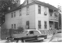
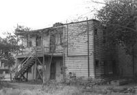
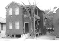
House (side view) on site affected by the construction of Interstate 26 (I-26). Surveyor notations on back of photo: "Dkt.: 10.480. Property owner: The Beach Company. Tract: 244. Station: 5705+35 Rt. Date: May 31, 1961. In R/W - Bought." [See collection description for explanation of surveyor notations.]
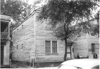
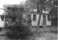
House (side view, rear) on site affected by the construction of the Crosstown. Address: 3 Todd Street. Surveyor notations on back of photo: "Dkt.: 10.524. Property owner: John W. Bonaparte, et al. Tract: 118. Station: 87+75 Rt. Date: Dec. 1, 1964. In R/W - Bought." [See collection description for explanation of surveyor notations.]
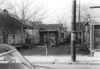
Houses (partial view) on site affected by the construction of the Crosstown. Address: 152-150 Line Street. Surveyor notations on back of photo: "Dkt.: 10.524. Property owner: John N. Peeksen. Tract: 117. Station: 86+70 Rt. Date: Dec. 1, 1964. In R/W." [See collection description for explanation of surveyor notations.]
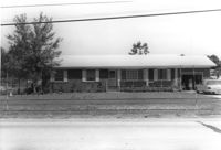
"Panoramic view" of houses on site affected by the construction of the Crosstown. Address: 152-150 Line Street. Surveyor notations on back of photo: "Dkt.: 10.524. Property owner: John N. Peeksen. Tract: 117. Station: 86+70 Rt. Date: Dec. 1, 1964. Panoramic View." [See collection description for explanation of surveyor notations.]
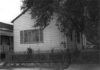
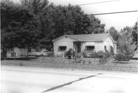
House on site affected by the construction of the Crosstown. Address: 8 Norman Street. Surveyor notations on back of photo: "Dkt.: 10.524. Property owner: Cassandra C. Curry. Tract: 21. Station: 67+30 Lt. Date: Oct. 13, 1964. In R/W - Bought." [See collection description for explanation of surveyor notations.]
House on site affected by the construction of the Crosstown. Address: 10 Todd Street. Surveyor notations on back of photo: "Dkt.: 10.524. Property owner: Gabriel W. Bonaparte. Tract: 122. Station: 88+65 Rt. Date: Dec. 2, 1964. In R/W - Bought." [See collection description for explanation of surveyor notations.]
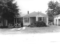
House on site affected by the construction of Interstate 26 (I-26). Surveyor notations on back of photo: "Dkt.: 10.480. Property owner: Mrs. Margaret H. Patterson. Tract: 241. Station: 5702+10 Lt. Date: May 31, 1961. In R/W - Bought." [See collection description for explanation of surveyor notations.]
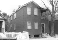
House on site affected by the construction of Interstate 26 (I-26). Surveyor notations on back of photo: "Dkt.: 10.480. Property owner: James H. Black. Tract: 245. Station: 5705+60 Rt. Date: May 31, 1961. In R/W - Bought." [See collection description for explanation of surveyor notations.]
House on site affected by the construction of Interstate 26 (I-26). Surveyor notations on back of photo: "Dkt.: 10.480. Property owner: The Beach Company. Tract: 244. Station: 5705+35 Rt. Date: May 31, 1961. In R/W - Bought." [See collection description for explanation of surveyor notations.]
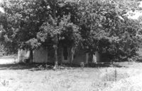
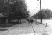
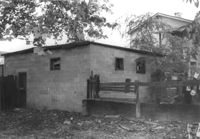
Cinderblock structure on site affected by the construction of Interstate 26 (I-26). Obscured by trees. Surveyor notations on back of photo: "Dkt.: 10.480. Property owner: Mrs. Margaret H. Patterson. Tract: 241. Station: 5702+60 Lt. Date: May 31, 1961. In R/W - Bought." [See collection description for explanation of surveyor notations.]
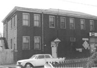
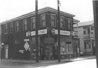
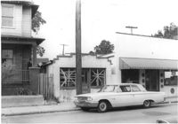
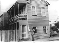
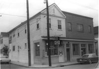
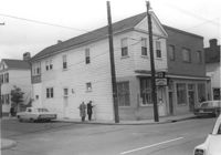
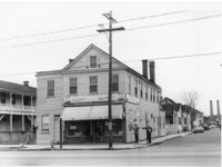
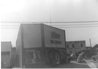
Building (residential and commercial) on site affected by the construction of the Crosstown. Address: 71 Lee Street. Sign for Ingram Fish Market on side of building. Surveyor notations on back of photo: "Dkt.: 10.518. Property owner: Virginia E.R. Ehlers. Tract: 28. Station: 41+15 CL S.B. lane Route 17. Date: Mar. 6, 1963. In R/W - Bought. [See collection description for explanation of surveyor notations.]
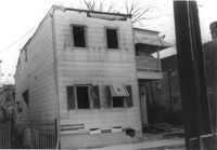
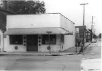
Pye's Fish Market, on site affected by the construction of the Crosstown. Address: 71 Lee Street. View of street corner. Same building as previous two photographs. `Surveyor notations on back of photo: "Dkt.: 10.518. Property owner: Virginia E.R. Ehlers. Tract: 28. Station: 41+15 CL S.B. lane Route 17. Date: Mar. 6, 1963. In R/W - Bought. [See collection description for explanation of surveyor notations.]
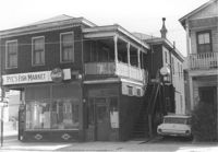
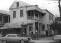
Pye's Fish Market, on site affected by the construction of the Crosstown. Address: 71 Lee Street. Same building as previous three photographs. `Surveyor notations on back of photo: "Dkt.: 10.518. Property owner: Virginia E.R. Ehlers. Tract: 28. Station: 41+15 CL S.B. lane Route 17. Date: Mar. 6, 1963. In R/W - Bought. [See collection description for explanation of surveyor notations.]
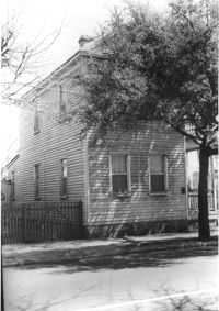
House on site affected by the construction of the Crosstown. Address: 282 Coming Street. Surveyor notations on back of photo: "Dkt.: 10.518. Property owner: M.J. Christine Butt, Est. Tract: 20. Station: 22+25 Rt. S.B. lane Route 17. Date: Mar. 6, 1963. In R/W - Bought. [See collection description for explanation of surveyor notations.]
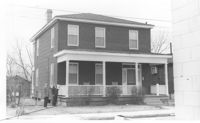
House on site affected by the construction of Interstate 26 (I-26). Address: 2125 Montford Avenue. Surveyor notations on back of photo: "Dkt.: 10.490. Property owner: John M. Heirs. Tract: 177. Station: 100' Lt. Sta. 5886+25. Date: May 15, 1962. In R/W - Bought." [See collection description for explanation of surveyor notations.]
House on site affected by the construction of the Crosstown. Address: 8 Norman Street. Surveyor notations on back of photo: "Dkt.: 10.524. Property owner: Cassandra C. Curry. Tract: 21. Station: 67+30 Lt. Date: Oct. 13, 1964. In R/W - Bought." [See collection description for explanation of surveyor notations.]
Building (rear view) and lot on site affected by the construction of the Crosstown. Address: 188 Spring Street. View looking towards street corner. Surveyor notations on back of photo: "Dkt.: 10.524. Property owner: E.H. Heidman, Est. Tract: 18. Station: 24+ Lt. (Spring Street). Date: Oct. 13, 1964." [See collection description for explanation of surveyor notations.]
Building, on site affected by the construction of the Crosstown. Address: 188½ Spring Street [188 Spring Street]. Front facade has stepped parapet. Surveyor notations on back of photo: "Dkt.: 10.524. Property owner: E.H. Heidman, Est. Tract: 18. Station: 24+ Lt. (Spring Street). Date: Oct. 13, 1964." [See collection description for explanation of surveyor notations.]
Building on site affected by the construction of the Crosstown. Address: 188 Spring Street. View of street corner. Surveyor notations on back of photo: "Dkt.: 10.524. Property owner: E.H. Heidman, Est. Tract: 18. Station: 24+ Lt. (Spring Street). Date: Oct. 13, 1964." [See collection description for explanation of surveyor notations.]
House (freedman's cottage) (rear view) on site affected by the construction of the Crosstown. Address: 6 Lee Street. Elevated roadway (presumably the off-ramp of the Grace Memorial Bridge) in background. Surveyor notations on back of photo: "Dkt.: 10.518. Property owner: William Parrineau, et al. Tract: 72. Station: 53+60 Lt. N.B. lane Route 17. 30+30Rt. Lee Street survey. Date: Mar. 7, 1963. In R/W - Bought." [See collection description for explanation of surveyor notations.]
House (freedman's cottage) (corner view, rear) on site affected by the construction of the Crosstown. Address: 2 Lee Street. Elevated roadway (presumably the off-ramp of the Grace Memorial Bridge) in background. Surveyor notations on back of photo: "Dkt.: 10.518. Property owner: Kate R. Rosen. Tract: 71. Station: 30+00 Rt. Lee St. survey. Date: Mar. 7, 1963. In R/W - Bought." [See collection description for explanation of surveyor notations.]
House (freedman's cottage) on site affected by the construction of the Crosstown. Address: 2 Lee Street. Posted sign indicates it is closed by the Board of Health. Surveyor notations on back of photo: "Dkt.: 10.518. Property owner: Kate R. Rosen. Tract: 71. Station: 30+00 Rt. Lee St. survey. 53+30 CL N.B. lane Rt. 17. Date: Mar. 7, 1963. In R/W - Bought." [See collection description for explanation of surveyor notations.]
House (freedman's cottage) on site affected by the construction of the Crosstown. Address: 2 Lee Street. Industrial smokestacks in background (Cigar Factory?). Surveyor notations on back of photo: "Dkt.: 10.518. Property owner: Kate R. Rosen. Tract: 70. Station: 53+00 Rt. N.B. lane Route 17. Date: Mar. 7, 1963. In R/W - Bought." [See collection description for explanation of surveyor notations.]
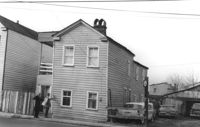
House (rear view) and outbuilding on site affected by the construction of the Crosstown. Address: 60-58 Aiken Street. Surveyor notations on back of photo: "Dkt.: 10.518. Property owner: Congaree Jenkins, Est. Tract: 54. Station: 48+00 Rt. N.B. lane Route 17. Date: Mar. 7, 1963." [See collection description for explanation of surveyor notations.]
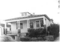
House on site affected by the construction of Interstate 26 (I-26). Address: 2126 Montford Avenue. Surveyor notations on back of photo: "Dkt.: 10.490. Property owner: Emory Hendrix, et al. Tract: 175. Station: 5884+80 Lt. Date: August 29, 1962. In R/W - Bought." [See collection description for explanation of surveyor notations.]
House on site affected by the construction of Interstate 26 (I-26).Address: 2123 Montford Avenue. Surveyor notations on back of photo: "Dkt.: 10.490. Property owner: B.H. Leopard. Tract: 177-A. Station: 135' Lt. Sta. 5886+55. Date: May 15, 1962. Proximity." [See collection description for explanation of surveyor notations.]
House on site affected by the construction of Interstate 26 (I-26). Address: 2127 Montford Avenue. Surveyor notations on back of photo: "Dkt.: 10.490. Property owner: The Beach Co. Tract: 178. Station: 5886±00 Lt. Date: August 29, 1962. In R/W - Bought." [See collection description for explanation of surveyor notations.]
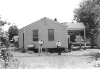
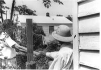
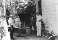
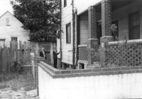
Surveyors clasping hands over fence at rear of house at backyard on site affected by the construction of Interstate 26 (I-26). Address: 2123 Montford Avenue. Surveyor notations on back of photo: "Dkt.: 10.490. Property owner: B.H. Leopard. Tract: 177-A. Station: 135' Lt. Sta. 5886+55. Date: May 15, 1962. Proximity." [See collection description for explanation of surveyor notations.]
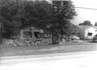
Roadside gift shop on site affected by the widening of U.S. Route 17. Lots of statuary on lot in front of structure. Presumably located in Mount Pleasant or vicinity. Surveyor notations on back of photo: "Dkt.: 10.439. Property owner: Adolph Benton, et al. Tract: 8. Station: 236+00 Rt. Date: Jul. 22, 1965. Range poles on 33' & 50' R/W - Cond." [See collection description for explanation of surveyor notations.]
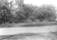
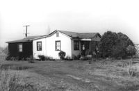
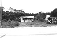
Lot and house (obscured by trees) on site affected by the widening of U.S. Route 17. Presumably located in Mount Pleasant or vicinity. Surveyor notations on back of photo: "Dkt.: 10.439. Property owner: Adolph Benton, et al. Tract: 8. Station: 234+73 to 236+73 Rt. Date: Jul. 22, 1965. Range poles on 33' & 50' R/W - Cond." [See collection description for explanation of surveyor notations.]
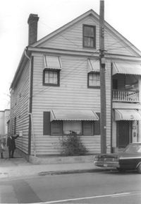
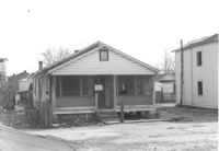
House (boarding house and tea room) on site affected by the construction of the Crosstown. Address: 199 Spring Street. Shows neon sign for Tea Room and signage advertising furnished rooms for rent. Surveyor notations on back of photo: "Dkt.: 10.524. Property owner: Elias A. Johnson, Sr. Tract: 171. Station: 22+45 Rt. Spring Street. Date: Dec. 2, 1964." [See collection description for explanation of surveyor notations.]
House (barely visible) and lot on site affected by the widening of U.S. Route 17. Presumably located in Mount Pleasant or vicinity. Surveyor notations on back of photo: "Dkt.: 10.439. Property owner: Willard B. Causey. Tract: 5. Station: 231+85 Rt. Date: Jul. 22, 1965. Proximity." [See collection description for explanation of surveyor notations.]
House (rear view) on site affected by the construction of the Crosstown. Address: 81 Kracke Street. Surveyor notations on back of photo: "Dkt.: 10.524. Property owner: Jerry M. Devoe. Tract: 69. Station: 77+80 Lt. Date: Oct. 14, 1964. In R/W - Bought." [See collection description for explanation of surveyor notations.]
House on site affected by the construction of the Crosstown. Address: 55 Aiken Street. Surveyor notations on back of photo: "Dkt.: 10.518. Property owner: Julius Mitchell. Tract: 53. Station: 47+20 Rt. N.B. lane Route 17. Date: Mar. 7, 1963." [See collection description for explanation of surveyor notations.]
House on site affected by the construction of the Crosstown. Address: 55 Aiken Street. Surveyor notations on back of photo: "Dkt.: 10.518. Property owner: Julius Mitchell. Tract: 53. Station: 47+20 Rt. N.B. lane Route 17. Date: Mar. 7, 1963." [See collection description for explanation of surveyor notations.]
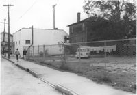
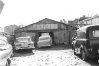
Structure (garage?) and cars in lot on site affected by the construction of the Crosstown. Address: 51 Aiken Street. Surveyor notations on back of photo: "Dkt.: 10.518. Property owner: Julia M. Pritchard. Tract: 52. Station: 46+50 Rt. N.B. lane Route 17. Date: Mar. 6, 1963. In R/W - Bought." [See collection description for explanation of surveyor notations.]
Site affected by the widening of State Road 13 (Remount Road). Surveyor notations on back of photo: "Dkt.: 10.562. Property owner: W.W. Walker, et al. Tract: 36-B. Date: Jul. 19, 1967." [See collection description for explanation of surveyor notations.]
House (boarding house and tea room) on site affected by the construction of the Crosstown. Address: 199 Spring Street. Shows neon sign for Tea Room and signage advertising furnished rooms for rent. Surveyor notations on back of photo: "Dkt.: 10.524. Property owner: Elias A. Johnson, Sr. Tract: 171. Station: 22+45 Rt. Spring Street. Date: Dec. 2, 1964." [See collection description for explanation of surveyor notations.]
Building (corner view), on site affected by the construction of the Crosstown. Address: 207 Spring Street. Sew-U-Save Shop. View of street corner (corner of Spring Street and Courtenay Street). Surveyor notations on back of photo: "Dkt.: 10.524. Property owner: Olympia Papaeilidow. Tract: 167. Station: 20+35 Rt. Spring Street. Date: Dec. 2, 1964." [See collection description for explanation of surveyor notations.]
Building (corner view), on site affected by the construction of the Crosstown. Address: 207 Spring Street. Sew-U-Save Shop. View of street corner (corner of Spring Street and Courtenay Street). Surveyor notations on back of photo: "Dkt.: 10.524. Property owner: Olympia Papaeilidow. Tract: 167. Station: 20+35 Rt. Spring Street. Date: Dec. 2, 1964." [See collection description for explanation of surveyor notations.]
House on site affected by the construction of the Crosstown. Address: 211 Spring Street. "Furnished Rooms" sign posted by door. Surveyor notations on back of photo: "Dkt.: 10.524. Property owner: Freda C. Doscher. Tract: 165. Station: 19+70 Rt. Spring Street. Date: Dec. 2, 1964. Condemned." [See collection description for explanation of surveyor notations.]
House on site affected by the construction of the Crosstown. Address: 203 Spring Street. First story is Riley's Beauty Shop. Surveyor notations on back of photo: "Dkt.: 10.524. Property owner: Samuel Riley. Tract: 169. Station: 21+65 Rt. Spring Street. Date: Dec. 2, 1964. Condemned." [See collection description for explanation of surveyor notations.]
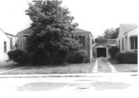
House on site affected by the construction of the Crosstown. Address: 265 Ashley Avenue. Surveyor notations on back of photo: "Dkt.: 10.524. Property owner: William A. Dart, et al. Tract: 80. Station: 78+90 CL Rt. Date: Oct. 14, 1964. In R/W - Bought." [See collection description for explanation of surveyor notations.]
Houses on site affected by the construction of the Crosstown. Address: 81 Kracke Street. Surveyor notations on back of photo: "Dkt.: 10.524. Property owner: Jerry M. Devoe. Tract: 69. Station: 77+40 Lt. Date: Oct. 14, 1964. In R/W - Bought." [See collection description for explanation of surveyor notations.]
House on site affected by the construction of the Crosstown. Address: 81 Kracke Street. Surveyor notations on back of photo: "Dkt.: 10.524. Property owner: Jerry M. Devoe. Tract: 69. Station: 77+80 Lt. Date: Oct. 14, 1964. In R/W - Bought." [See collection description for explanation of surveyor notations.]
Rear view of structure on site affected by the construction of the Crosstown. Address: 81 Kracke Street. Surveyor notations on back of photo: "Dkt.: 10.524. Property owner: Jerry M. Devoe. Tract: 69. Station: 77+40 Lt. Date: Oct. 14, 1964. In R/W - Bought." [See collection description for explanation of surveyor notations.]
Corner grocery store on site affected by the construction of Interstate 26 (I-26). Address: 506 Meeting Street. View of street corner (northwest corner of Meeting Street and Sheppard Street). Smokestacks in background (Cigar Factory?). Surveyor notations on back of photo: "Dkt.: 10.517. Property owner: Rose D. Brady. Tract 64. Station: 5963+50 Lt. - Line 6. Date: March 5, 1963. Partially in R/W." [See collection description for explanation of surveyor notations.]
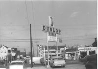
Gibson Tire Service on site affected by the construction of Interstate 26 (I-26). Address: 521 Meeting Street or 523 Meeting Street. Corner of Meeting Street and Lee Street. Surveyor notations on back of photo: "Dkt.: 10.517. Property owner: Thomas P. Gibson. Tract: 59. Station: 36+15 - 37+03 Rt. & Lt. Route 17. Date: February 21, 1963. All in R/W." [See collection description for explanation of surveyor notations.]
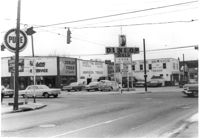
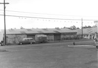
Busy intersection on site affected by the construction of Interstate 26 (I-26). Address: intersection of Lee Street and meeting Street. Features Gibson Tire Service / Dunlop Tires; sign for Pure gas station in left foreground. Surveyor notations on back of photo: "Dkt.: 10.517. Property owner: Thomas P. Gibson. Tract: 59. Station: 37±00 Lt. - Route 17 survey. Date: March 5, 1963. All in R/W." [See collection description for explanation of surveyor notations.]
Busy intersection on site affected by the construction of Interstate 26 (I-26). Address: intersection of Lee Street and Meeting Street. Pure gas station, Gibson Tire Service / Dunlop Tires, and Sinclair gas station in view. Surveyor notations on back of photo: "Dkt.: 10.517. Property owner: Thomas P. Gibson. Tract: 59. Station: 37±00 Lt. - Route 17. Date: February 21, 1963. All in R/W." [See collection description for explanation of surveyor notations.]
House (rear view) on site affected by the construction of Interstate 26 (I-26). Address: 90 Lee Street. Surveyor notations on back of photo: "Dkt.: 10.517. Property owner: Lillian M. Simmons. Tract: 50. Station: 5954+15 CL - Line 6. Date: February 21, 1963. In R/W - Bought." [See collection description for explanation of surveyor notations.]
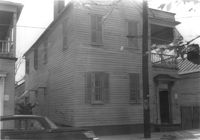
House (corner view, rear) on site affected by the construction of Interstate 26 (I-26). Partially obscured by trees. Surveyor notations on back of photo: "Dkt.: 10.480. Property owner: C.G. Hudson. Tract: 250. Station: 5706+30 Lt. Date: May 31, 1961. In R/W - Bought." [See collection description for explanation of surveyor notations.]
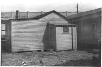
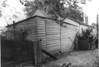
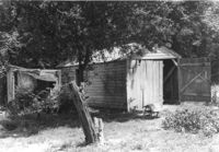
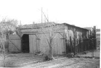
Sheds in dilapidated condition on site affected by the construction of Interstate 26 (I-26). Surveyor notations on back of photo: "Dkt.: 10.480. Property owner: C.G. Hudson. Tract: 250. Station: 5706+30 Lt. Date: May 31, 1961. In R/W - Bought." [See collection description for explanation of surveyor notations.]
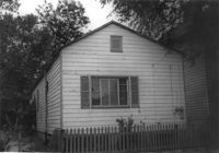
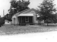
House on site affected by the construction of Interstate 26 (I-26). Building address number 80. Surveyor notations on back of photo: "Dkt.: 10.480. Property owner: William F. Carter. Tract: 243. Station: 5704+85 Rt. Date: May 31, 1961. In R/W - Bought." [See collection description for explanation of surveyor notations.]
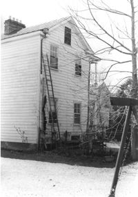
House (rear view) on site affected by the construction of Interstate 26 (I-26). Surveyor notations on back of photo: "Dkt.: 10.480. Property owner: Paul H. Rogers. Tract: 237. Station: 5700+00 Lt. Date: May 31, 1961. In R/W - Bought." [See collection description for explanation of surveyor notations.]
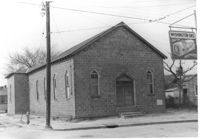
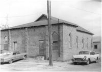
Mount Pisgah Baptist Church on site affected by the construction of Interstate 26 (I-26). Address: northwest corner of C and E Street. Sign for Washington Grocery in foreground at right (appears to be across the street). Surveyor notations on back of photo: "Dkt.: 10.517. Property owner: Mt. Pisgah Baptist Church. Tract: 21. Station: 5946+40 CL - Line 6. Date: February 21, 1963. In R/W - Bought." [See collection description for explanation of surveyor notations.]
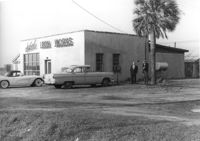
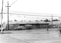
Sabel Iron Works, on site affected by the widening of Route 171 (Folly Road). Surveyor notations on back of photo: "Dkt.: 10.494. Property owner: Sophie Sabel, Est. Tract: 97. Station: 367+50 Lt. Date: Mar. 21, 1962. To be cut off at R/W by SCHD [SC Highway Dept.?]. [See collection description for explanation of surveyor notations.]
Sabel Iron Works, on site affected by the widening of Route 171 (Folly Road). Surveyor notations on back of photo: "Dkt.: 10.494. Property owner: Sophie Sabel, Est. Tract: 97. Station: 367+50 Lt. Date: Mar. 21, 1962. To be cut off at R/W by SCHD [SC Highway Dept.?]. [See collection description for explanation of surveyor notations.]
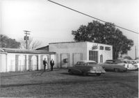
Renken Boat Co, on site affected by the widening of Route 171 (Folly Road). Surveyor notations on back of photo: "Dkt.: 10.494. Property owner: Renken Finance Co. Tract: 19. Station: 157+00 Lt. Date: Mar. 21, 1962. Proximity. [See collection description for explanation of surveyor notations.]
Mount Pisgah Baptist Church (rear view, corner) on site affected by the construction of Interstate 26 (I-26). Address: northwest corner of C and E Street. Surveyor notations on back of photo: "Dkt.: 10.517. Property owner: Mt. Pisgah Baptist Church. Tract: 21. Station: 5946+40 CL - Line 6. Date: February 21, 1963. In R/W - Bought." [See collection description for explanation of surveyor notations.]
House on site affected by the construction of Interstate 26 (I-26). Address: 1 A Street (now 1 Walnut Street). Surveyor notations on back of photo: "Dkt.: 10.517. Property owner: Theresa H. Walker. Tract: 49. Station: 5953+15 Lt. - Line 6. Date: February 21, 1963. In R/W - Bought." [See collection description for explanation of surveyor notations.]
House on site affected by the construction of Interstate 26 (I-26). Address: 90 Lee Street. Surveyor notations on back of photo: "Dkt.: 10.517. Property owner: Lillian M. Simmons. Tract: 50. Station: 5954+15 CL - Line 6. Date: February 21, 1963. In R/W - Bought." [See collection description for explanation of surveyor notations.]
Large shed or garage on site affected by the construction of Interstate 26 (I-26). Address: 90 Lee Street. Surveyor notations on back of photo: "Dkt.: 10.517. Property owner: Lillian M. Simmons. Tract: 50. Station: 5953+50 Lt. - Line 6. Date: February 21, 1963. In R/W - Bought." [See collection description for explanation of surveyor notations.]
Wooden structures (sheds?) on site affected by the construction of Interstate 26 (I-26). Address: 92 Lee Street (rear). Surveyor notations on back of photo: "Dkt.: 10.517. Property owner: Robert L. Chamberlain, et al. Tract: 51. Station: 5953+60 CL - Line 6. Date: February 21, 1963. In R/W - Bought." [See collection description for explanation of surveyor notations.]
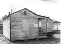
House (freedman's cottage) on site affected by the construction of Interstate 26 (I-26). Surveyor notations on back of photo: "Dkt.: 10.490. Property owner: Janie Simmons. Tract: 41. Station: 5798+30 on CL Line 'G'. Date: September 12, 1962. In R/W - Bought." [See collection description for explanation of surveyor notations.]
Renken Boat Co, on site affected by the widening of Route 171 (Folly Road). Surveyor notations on back of photo: "Dkt.: 10.494. Property owner: Renken Finance Co. Tract: 19. Station: 157+00 Lt. Date: Mar. 21, 1962. Proximity. [See collection description for explanation of surveyor notations.]
House in somewhat dilapidated condition, possibly rear view (obscured by tall grass), on site affected by the construction of Interstate 26 (I-26). Surveyor notations on back of photo: "Dkt.: 10.490. Property owner: Sylvia Yaschik. Tract: 40. Station: 5798+00 on CL Line 'G'. Date: September 12, 1962. In R/W - Bought." [See collection description for explanation of surveyor notations.]
House and carport on site affected by the construction of the Crosstown. Address: 4 Norman Street. Surveyor notations on back of photo: "Dkt.: 10.524. Property owner: Madeline B. Allen, et al. Tract: 23. Station: 66+55 Lt. Date: Oct. 13, 1964. In R/W - Bought." [See collection description for explanation of surveyor notations.]
House (side view) on site affected by the construction of the Crosstown. Address: 162 President Street. Surveyor notations on back of photo: "Dkt.: 10.524. Property owner: Emily M. Simmons. Tract: 40. Station: 70+35 Lt. Date: Oct. 14, 1964. In R/W - Bought." [See collection description for explanation of surveyor notations.]
House on site affected by the construction of the Crosstown. Address: 129 Bogard Street. Surveyor notations on back of photo: "Dkt.: 10.524. Property owner: Maxine T. Freidenberg. Tract: 45. Station: 72+10 Lt. Date: Oct. 14, 1964. Portion in R/W to be removed." [See collection description for explanation of surveyor notations.]
House on site affected by the widening of Route 171 (Folly Road). Surveyor notations on back of photo: "Dkt.: 10.494. Property owner: John Richardson, Est. Tract: 94. Station: 338+70 Lt. Date: Mar. 21, 1962. To be cut off at R/W by SCHD [SC Highway Dept.?]. [See collection description for explanation of surveyor notations.]
House on site affected by the widening of Route 171 (Folly Road). Wooden stand in foreground. Surveyor notations on back of photo: "Dkt.: 10.494. Property owner: Robert Richardson, et al. Tract: 90. Station: 310+00 Lt. Date: Mar. 21, 1962. Proximity. [See collection description for explanation of surveyor notations.]
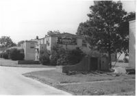
Neon entrance sign for Rose Garden Tourist Court, with two-story dwellings in background, on site affected by the construction of Interstate 26 (I-26). Address: 1317 King Street. Surveyor notations on back of photo: "Dkt.: 10.490. Property owner: The Long Corporation. Tract: 200. Station: 5+50 & 6+20 Lt. (Mt. Pleasant Street). Date: September 11, 1962. In R/W - Bought." [See collection description for explanation of surveyor notations.]
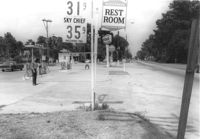
Texaco gas station, on site affected by the widening of State Road 13 (Remount Road). Neighboring Gulf gas Station: in background. Surveyor notations on back of photo: "Dkt.: 10.562. Property owner: W.L. Dyches, et al. Tract: 23. Date: Jul. 12, 1967." [See collection description for explanation of surveyor notations.]
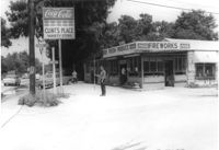
Clint's Place - Variety Store, corner of Craig Road, on site affected by the widening of State Road 13 (Remount Road). View of street corner. Surveyor notations on back of photo: "Dkt.: 10.562. Property owner: Samuel C. Rollings. Tract: 10. Date: Jul. 12, 1967." [See collection description for explanation of surveyor notations.]
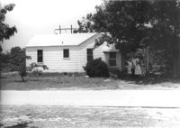
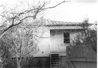
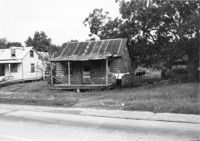
House in dilapidated condition on site affected by the widening of U.S. Route 17. Presumably located in Mount Pleasant or vicinity. Surveyor notations on back of photo: "Dkt.: 10.597. Property owner: Isaac Snype, Estate. Tract: 39. Station: 288+10 Lt. Date: Sept. 17, 1968." [See collection description for explanation of surveyor notations.]
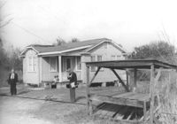
House on site affected by the widening of U.S. Route 17. Sweetgrass basket stand at right. Presumably located in Mount Pleasant or vicinity. Surveyor notations on back of photo: "Dkt.: 10.597. Property owner: Will Jones. Tract: 77-A. Station: 440+00 Lt. Date: Sept. 17, 1968." [See collection description for explanation of surveyor notations.]
House on site affected by the construction of the Crosstown. Address: 129 Bogard Street. Surveyor notations on back of photo: "Dkt.: 10.524. Property owner: Maxine T. Freidenberg. Tract: 45. Station: 72+10 Lt. Date: Oct. 14, 1964. Portion in R/W to be removed." [See collection description for explanation of surveyor notations.]
House on site affected by the construction of the Crosstown. Address: 163A Line Street [163 Line Street]. Surveyor notations on back of photo: "Dkt.: 10.524. Property owner: Ethelyn M. Parker. Tract: 95. Station: 82+50 Rt. Date: Dec. 1, 1964. In R/W - Bought." [See collection description for explanation of surveyor notations.]
House on site affected by the construction of the Crosstown. Address: 96 Sheppard Street. Surveyor notations on back of photo: "Dkt.: 10.518. Property owner: Celia McFadden. Tract: 18. Station: 30+10 Lt. Sheppard Street. Date: Mar. 6, 1963. In R/W - Bought. [See collection description for explanation of surveyor notations.]
House on site affected by the construction of the Crosstown. Address: 96 Sheppard Street. Surveyor notations on back of photo: "Dkt.: 10.518. Property owner: Celia McFadden. Tract: 18. Station: 30+10 Lt. Sheppard Street. Date: Mar. 6, 1963. In R/W - Bought. [See collection description for explanation of surveyor notations.]
House on site affected by the construction of the Crosstown. Address: 94 Sheppard Street. Surveyor notations on back of photo: "Dkt.: 10.518. Property owner: Alice Davis. Tract: 17. Station: 30+55 Lt. Sheppard Street. Date: Mar. 6, 1963. Proximity. [See collection description for explanation of surveyor notations.]
House (corner view, side or rear) on site affected by the construction of Interstate 26 (I-26). Address: 7 A Street (now 7 Walnut Street), at corner of C Street. Appears to be a duplex. Surveyor notations on back of photo: "Dkt.: 10.517. Property owner: H.B. Hogg, Est. Tract: 47. Station: 5951+80 Lt. - Line 6. Date: February 21, 1963. In R/W - Bought." [See collection description for explanation of surveyor notations.]
House (corner view, side or rear) on site affected by the construction of Interstate 26 (I-26). Address: 7½ A Street (now 7½ Walnut Street), at corner of C Street. Surveyor notations on back of photo: "Dkt.: 10.517. Property owner: H.B. Hogg, Est. Tract: 47. Station: 5951+85 Rt. - Line 6. Date: February 21, 1963. In R/W - Bought." [See collection description for explanation of surveyor notations.]
House on site affected by the construction of Interstate 26 (I-26). Address: 7 A Street (now 7 Walnut Street), at corner of C Street. Appears to be a duplex. Surveyor notations on back of photo: "Dkt.: 10.517. Property owner: H.B. Hogg, Est. Tract: 47. Station: 5951+80 Lt. - Line 6. Date: February 21, 1963. In R/W - Bought." [See collection description for explanation of surveyor notations.]
House on site affected by the widening of U.S. Route 17. Presumably located in Mount Pleasant or vicinity. Surveyor notations on back of photo: "Dkt.: 10.439. Property owner: Adolph Benton, et al. Tract: 8. Station: 235+20 Rt. Date: Jul. 22, 1965. Range poles on 33' & 50' R/W - Cond." [See collection description for explanation of surveyor notations.]
House on site affected by the widening of U.S. Route 17. Presumably located in Mount Pleasant or vicinity. Surveyor notations on back of photo: "Dkt.: 10.439. Property owner: W.G. Benton, et al. Tract: 7. Station: 234±15 Rt. Date: Jul. 22, 1965. Range poles on 33' & 50' R/W - Cond." [See collection description for explanation of surveyor notations.]
House on site affected by the construction of Interstate 26 (I-26).Address: 2133 Montford Avenue. Front of house almost completely obscured by trees. Surveyor notations on back of photo: "Dkt.: 10.490. Property owner: Floyd R. Wohnig. Tract: 181. Station: 5885+55 Rt. Date: May 15, 1962. In R/W - Bought." [See collection description for explanation of surveyor notations.]
Rear corner of house on site affected by the construction of the Crosstown. Address: 6 Kennedy Street. Surveyor notations on back of photo: "Dkt.: 10.524. Property owner: Eugene Whitney. Tract: 89. Station: 81+80 Rt. Date: Oct. 14, 1964." [See collection description for explanation of surveyor notations.]
House on site affected by the construction of the Crosstown. Address: 269 Ashley Avenue. Surveyor notations on back of photo: "Dkt.: 10.524. Property owner: Paul Graham. Tract: 82. Station: 79+20 Lt. Date: Oct. 14, 1964. In R/W - Bought." [See collection description for explanation of surveyor notations.]
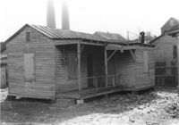
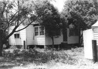
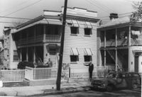
House on site affected by the construction of Interstate 26 (I-26). Neighboring dwellings also in photo. Surveyor notations on back of photo: "Dkt.: 10.480. Property owner: Central McMillan, et al. Tract: 38. Station: 5508+90 Rt. Date: May 2, 1961. In R/W - Bought." [See collection description for explanation of surveyor notations.]
Cinder block structure on site affected by the construction of the Crosstown. Address: 15 Kennedy Street. Surveyor notations on back of photo: "Dkt.: 10.524. Property owner: J. Arthur Brown. Tract: 84. Station: 78+35 Lt. Date: Oct. 14, 1964. In R/W - Bought." [See collection description for explanation of surveyor notations.]
House on site affected by the construction of Interstate 26 (I-26). Address: 14 Wood Street. Surveyor notations on back of photo: "Dkt.: 10.503. Property owner: Walter K. Brown. Tract: 32. Station: 5900+10 Lt. Date: Feb. 19, 1963. In R/W - Bought." [See collection description for explanation of surveyor notations.]
House on site affected by the construction of Interstate 26 (I-26). Address: 9 Wood Street. Surveyor notations on back of photo: "Dkt.: 10.503. Property owner: Janie Washington. Tract: 34. Station: 5901+00 Lt. Date: Feb. 19, 1963. In R/W - Bought." [See collection description for explanation of surveyor notations.]
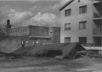
Construction debris and neighboring buildings on site affected by the construction of Interstate 26 (I-26). Address: 1220 King Street. Coca Cola Bottling Co. building (1129 Meeting Street) in background. Surveyor notations on back of photo: "Dkt.: 10.503. Property owner: House of God. Tract: 31. Station: 5900+30 Lt. Date: Feb. 19, 1963. In R/W - Bought." [See collection description for explanation of surveyor notations.]
Lot on site affected by the widening of U.S. Route 17. Presumably located in southern Charleston County. Surveyor notations on back of photo: "Dkt.: 10.600. Property owner: R. Arnold Postell. Tract: 16. Station: 630± Rt. Date: Sept. 18, 1968." [See collection description for explanation of surveyor notations.]
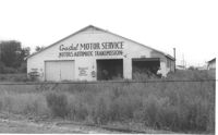
Coastal Motor Service, on site affected by the construction of Interstate 26 (I-26). Surveyor notations on back of photo: "Dkt.: 10.490. Property owner: Ashley River Realty Co. Tract: 141. Station: 5872+00 Lt. Date: August 29, 1962. Proximity." [See collection description for explanation of surveyor notations.]
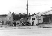
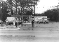
Spar gas station, on site affected by the widening of Route 171 (Folly Road). Surveyor notations on back of photo: "Dkt.: 10.494. Property owner: Palm Oil Co. Tract: 45. Station: 176+80 Lt. Date: Mar. 21, 1962. Owner to move pumps. [See collection description for explanation of surveyor notations.]
Renken Boat Co, on site affected by the widening of Route 171 (Folly Road). Surveyor notations on back of photo: "Dkt.: 10.494. Property owner: Renken Finance Co. Tract: 19. Station: 157+00 Lt. Date: Mar. 21, 1962. Proximity. [See collection description for explanation of surveyor notations.]