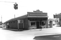
Building, on site affected by the construction of the Crosstown. Address: 626 King Street. Front facade has stepped parapet. View of street corner, with directional signage for Routes 78, 17, 52. Surveyor notations on back of photo: "Dkt.: 10.518. Property owner: Sands & Co. Tract: 16. Station: 9+50 Lt. Line Street (Line #2). Date: Mar. 6, 1963." [See collection description for explanation of surveyor notations.]
Building on site affected by the construction of the Crosstown. Address: 119 Drake Street (based on neighboring house number). Elevated roadway (presumably the off-ramp of the Grace Memorial Bridge) in background. Surveyor notations on back of photo: "Dkt.: 10.518. Property owner: Mt. Sinai Mission. Tract: 76. Station: 54+80 Rt. N.B. lane Route 17. Date: Mar. 7, 1963. In R/W - Bought." [See collection description for explanation of surveyor notations.]
Building (rear view) on site affected by the construction of the Crosstown. Address: 119 Drake Street (based on neighboring house number). Surveyor notations on back of photo: "Dkt.: 10.518. Property owner: Mt. Sinai Mission. Tract: 76. Station: 54+80 Rt. N.B. lane Route 17. Date: Mar. 7, 1963. In R/W - Bought." [See collection description for explanation of surveyor notations.]
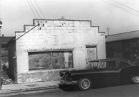
Dilapidated structure (possibly had commercial use) on site affected by the construction of Interstate 26 (I-26). Address: 3 C Street. "Saw Filing" sign posted on rail. Front facade has stepped parapet. Surveyor notations on back of photo: "Dkt.: 10.517. Property owner: J.W. Prescott. Tract: 43. Station: 5950+60 CL Line 2. Date: February 21, 1963. In R/W - Bought." [See collection description for explanation of surveyor notations.]
Dilapidated structure (rear view) on site affected by the construction of Interstate 26 (I-26). Address: 3 C Street. Surveyor notations on back of photo: "Dkt.: 10.517. Property owner: J.W. Prescott. Tract: 43. Station: 5950+60 CL - Line 2. Date: February 21, 1963. In R/W - Bought." [See collection description for explanation of surveyor notations.]
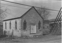
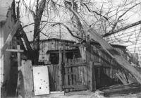
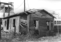
Dilapidated structure on site affected by the construction of Interstate 26 (I-26). Address: 22½ Poinsett Street (rear). Surveyor notations on back of photo: "Dkt.: 10.503. Property owner: J.W. Blanchard, Est. Tract: 102. Station: 5921+00 Lt. Date: Feb. 20, 1963. In R/W - Bought." [See collection description for explanation of surveyor notations.]
Building, on site affected by the construction of the Crosstown. Address: 80 Cooper Street. Front facade has stepped parapet. Surveyor notations on back of photo: "Dkt.: 10.518. Property owner: Helen Phillips Brown. Tract: 9. Station: 38+95 Rt. N.B. lane Route 17. Date: Mar. 6, 1963. In R/W - Bought. [See collection description for explanation of surveyor notations.]
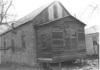
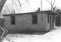
Building on site affected by the construction of Interstate 26 (I-26). Address: 15½ Addison Street (rear) [15 Addison Street]. Surveyor notations on back of photo: "Dkt.: 10.503. Property owner: Evan Gethers, et al. Tract: 100. Station: 5920+45 Lt. Date: Feb. 20, 1963. In R/W - Bought." [See collection description for explanation of surveyor notations.]
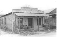
Dilapidated structure on site affected by the construction of Interstate 26 (I-26). Address: 35½ Poinsett Street. Bus in background. Surveyor notations on back of photo: "Dkt.: 10.503. Property owner: Manuel F. Fernandez. Tract: 106. Station: 5923+10 Lt. Date: Feb. 20, 1963. In R/W - Bought." [See collection description for explanation of surveyor notations.]
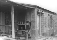
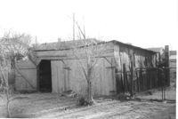
Large shed or garage on site affected by the construction of Interstate 26 (I-26). Address: 90 Lee Street. Surveyor notations on back of photo: "Dkt.: 10.517. Property owner: Lillian M. Simmons. Tract: 50. Station: 5953+50 Lt. - Line 6. Date: February 21, 1963. In R/W - Bought." [See collection description for explanation of surveyor notations.]
Right of way--South Carolina--Charleston County, Highway planning--South Carolina--Charleston County, Vernacular architecture--South Carolina--Charleston County, Lost architecture--South Carolina--Charleston County✖[remove]12