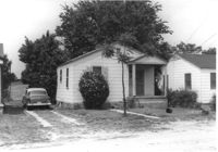
House on site affected by the construction of Interstate 26 (I-26). Surveyor notations on back of photo: "Dkt.: 10.471. Property owner: Mildred G. Bowers. Tract: 141. Station: 3+00 Lt. (Remount Road). Date: Aug. 23, 1960. Proximity." [See collection description for explanation of surveyor notations.]
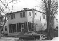
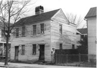
House (freedman's cottage) on site affected by the construction of the Crosstown. Address: 28 Lee Street (28 1/3 Lee Street). Billboard from Photo 127 in background. Surveyor notations on back of photo: "Dkt.: 10.518. Property owner: Sara Johnson, et al. Tract: 81. Station: 53+45 Rt. N.B. lane Route 17. Date: Mar. 7, 1963." [See collection description for explanation of surveyor notations.]
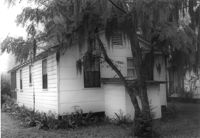
House (freedman's cottage) on site affected by the construction of the Crosstown. Address: 6 Lee Street. Surveyor notations on back of photo: "Dkt.: 10.518. Property owner: William Parrineau, et al. Tract: 72. Station: 53+60 Lt. N.B. lane Route 17. 30+30Rt. Lee Street survey. Date: Mar. 7, 1963. In R/W - Bought." [See collection description for explanation of surveyor notations.]
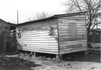
Outbuilding on site affected by the construction of the Crosstown. Address: 39 Lee Street (south side of street). Surveyor notations on back of photo: "Dkt.: 10.518. Property owner: Yetta B. Rosen. Tract: 69. Station: 52+70 Rt. N.B. lane Route 17. Date: Mar. 7, 1963. In R/W - Bought." [See collection description for explanation of surveyor notations.]
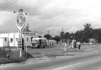
Sinclair gasoline station on site affected by the construction of Interstate 26 (I-26). Surveyor notations on back of photo: "Dkt.: 10.471. Property owner: Sinclair Refining Co. Tract: 138. Station: 1+50 Rt. (Remount Road). Date: Aug. 23, 1960. Proximity." [See collection description for explanation of surveyor notations.]
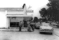
Arrow Restaurant, on site affected by the widening of State Road 13 (Remount Road). Surveyor notations on back of photo: "Dkt.: 10.562. Property owner: F.L. Parks, Jr. Tract: 3. Date: Jul. 12, 1967." [See collection description for explanation of surveyor notations.]
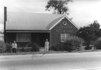
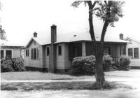
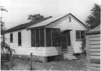
House and shed at end of driveway on site affected by the construction of Interstate 26 (I-26). Address: 2137 Courtland Avenue. Surveyor notations on back of photo: "Dkt.: 10.490. Property owner: Baynard C. Lynes. Tract: 167. Station: 50' Rt. Sta. 5883+10. Date: May 15, 1962. In R/W - Bought." [See collection description for explanation of surveyor notations.]
Orkin Pest Control - Termite Control, corner of Ashley Hall Road and Route 7 (Sam Rittenberg Boulevard), on site affected by the widening of Routes 7 & 171. Surveyor notations on back of photo: "Dkt.: 10.551. Property owner: Atlantic Investment & Development Co. Tract: 4. Station: 127±00 Rt. Date: Jul. 22, 1965. Same as Photo 5, view from across Ashley Hall Rd. looking north. [See collection description for explanation of surveyor notations.]
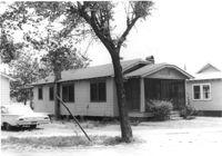
House on site affected by the widening of State Road 13 (Remount Road). Rear view. Surveyor notations on back of photo: "Dkt.: 10.562. Property owner: Charles R. Roberson. Tract: 36-A. Date: Jul. 19, 1967." [See collection description for explanation of surveyor notations.]
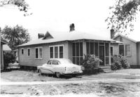
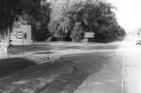
Site affected by the widening of State Road 13 (Remount Road). Surveyor notations on back of photo: "Dkt.: 10.562. Property owner: F.L. Parks, Jr. Tract: 3. Date: Jul. 12, 1967." [See collection description for explanation of surveyor notations.]
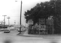
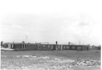
Corner view of Idamor Trailer Park and Apartments, with signage for Commissary Store - Navy Exchange Country Store and for E.M. Club - Eliza Lucas Hall, on site affected by the widening of State Road 31 (Reynolds Avenue). Surveyor notations on back of photo: "Dkt.: 10.541. Property owner: Morris P. Sokol, et al. Tract: 1. Station: 4+8 Lt. Date: Apr. 20, 1965." [See collection description for explanation of surveyor notations.]
Mt. Pleasant Motel, on site affected by the widening of U.S. Route 17. Presumably located in Mount Pleasant or vicinity. Surveyor notations on back of photo: "Dkt.: 10.439. Property owner: George A. Kaiser, et al. Tract: 16. Station: 225+51 to 228+52 Lt. Date: Jul. 22, 1965. Range poles on 50' R/W. Face of brick columns on 33' R/W - Cond." [See collection description for explanation of surveyor notations.]
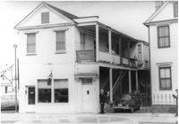
Building with ground-story business, Sunset Memorial Gardens, and second-story residence, on site affected by the construction of Interstate 26 (I-26). Address: 642 King Street. Surveyor notations on back of photo: "Dkt.: 10.517. Property owner: N.W. Cabell. Tract: 80. 29+00 Rt. Northbound Lane. Date: March 5, 1963. In R/W - Bought." [See collection description for explanation of surveyor notations.]
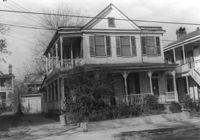
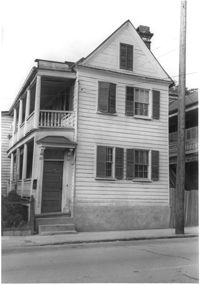
House (corner view, rear) on site affected by the construction of Interstate 26 (I-26). Address: 268 St. Philip Street. Surveyor notations on back of photo: "Dkt.: 10.517. Property owner: Sara Fox. Tract: 113. Station: 25+20 Rt. Southbound Lane Route 17. Date: March 5, 1963. In R/W - Bought." [See collection description for explanation of surveyor notations.]
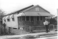
House, likely on Spruill Avenue, on site affected by the construction of Interstate 26 (I-26). Surveyor notations on back of photo: "Dkt.: 10.490. Property owner: Ellen Hartfield, Estate. Tract: 2. Station: 46+15 Rt. (Spruill Ave.). Date: November 4, 1965. Side view of subject property. Range poles on new R/W. Proximity." [See collection description for explanation of surveyor notations.]
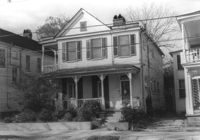
House on site affected by the construction of Interstate 26 (I-26). Address: 270 St. Philip Street. Surveyor notations on back of photo: "Dkt.: 10.517. Property owner: William H. Steedley. Tract: 114. Station: 25+40 Rt. Southbound Lane Route 17. Date: March 5, 1963. In R/W - Bought." [See collection description for explanation of surveyor notations.]
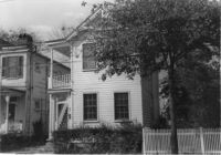
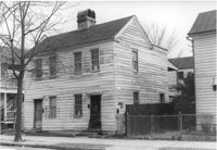
House on site affected by the construction of Interstate 26 (I-26). Address: 69 Fishburne Street. Surveyor notations on back of photo: "Dkt.: 10.517. Property owner: Ben F. Yancy, et al. Tract: 116. Station: 26+30 CL Southbound Lane Route 17. Date: March 5, 1963. In R/W - Bought." [See collection description for explanation of surveyor notations.]
House on site affected by the construction of Interstate 26 (I-26). Address: 1340 Rutledge Avenue. Surveyor notations on back of photo: "Dkt.: 10.490. Property owner: Louise S. Carter. Tract: 156. Station: 5880+80 Rt. Date: May 15, 1962. In R/W - Bought." [See collection description for explanation of surveyor notations.]
House on site affected by the construction of Interstate 26 (I-26). Address: 1342 Rutledge Avenue. Surveyor notations on back of photo: "Dkt.: 10.490. Property owner: Louise S. Carter. Tract: 155. Station: 5880+40 Rt. Date: May 15, 1962. In R/W - Bought." [See collection description for explanation of surveyor notations.]
House on site affected by the construction of Interstate 26 (I-26). Address: 1344 Rutledge Avenue. Surveyor notations on back of photo: "Dkt.: 10.490. Property owner: Louise S. Carter. Tract: 154. Station: 5880+00 Rt. Date: May 15, 1962. In R/W - Bought." [See collection description for explanation of surveyor notations.]
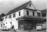
Basser's Friendly Self Service (corner view) on site affected by the construction of the Crosstown. Address: 186 Spring Street. View of street corner. Surveyor notations on back of photo: "Dkt.: 10.524. Property owner: Mona G. Sokol. Tract: 25. Station: 65+60 CL Lt. Date: Oct. 13, 1964. In R/W - Bought." [See collection description for explanation of surveyor notations.]
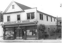
Basser's Friendly Self Service, on site affected by the construction of the Crosstown. Address: 186 Spring Street. Surveyor notations on back of photo: "Dkt.: 10.524. Property owner: Mona G. Sokol. Tract: 25. Station: 65+60 CL Lt. Date: Oct. 13, 1964. In R/W - Bought." [See collection description for explanation of surveyor notations.]
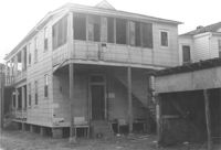
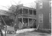
House (rear view) on site affected by the construction of the Crosstown. Address: 20 Cooper Street (based on 1951 Sanborn Map, perhaps behind 22 Cooper Street). Elevated roadway (presumably the off-ramp of the Grace Memorial Bridge) in background. Surveyor notations on back of photo: "Dkt.: 10.518. Property owner: Toots Brown. Tract: 79. Station: 54+25 Rt. N.B. lane Route 17. Date: Mar. 7, 1963. In R/W - Bought." [See collection description for explanation of surveyor notations.]
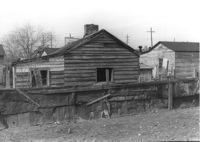
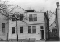
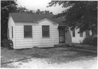
House (rear view?) on site affected by the construction of Interstate 26 (I-26). Building address number 1800. Possibly on Rivers Avenue. Surveyor notations on back of photo: "Dkt.: 10.486. Property owner: G.P. Parris, Est. Tract: 6. Station: 9+50 Lt. Date: May 30, 1961. In R/W - Bought." [See collection description for explanation of surveyor notations.]
House on site affected by the construction of the Crosstown. Address: 106 Sheppard Street. Surveyor notations on back of photo: "Dkt.: 10.524. Property owner: Annie H. Powers. Tract: 149. Station: 20+65 Rt. S.B. lane. Date: Dec. 2, 1964. In R/W - Bought." [See collection description for explanation of surveyor notations.]
House on site affected by the construction of the Crosstown. Address: 106 Sheppard Street. Surveyor notations on back of photo: "Dkt.: 10.524. Property owner: Annie H. Powers. Tract: 149. Station: 20+65 Rt. S.B. lane. Date: Dec. 2, 1964. In R/W - Bought." [See collection description for explanation of surveyor notations.]
House on site affected by the construction of the Crosstown. Address: 104 Sheppard Street. Surveyor notations on back of photo: "Dkt.: 10.524. Property owner: Rachel Bailey. Tract: 150. Station: 20+95 Rt. S.B. lane. Date: Dec. 2, 1964. In R/W - Bought." [See collection description for explanation of surveyor notations.]
House on site affected by the construction of the Crosstown. Address: 104 Sheppard Street. Surveyor notations on back of photo: "Dkt.: 10.524. Property owner: Rachel Bailey. Tract: 150. Station: 20+95 Rt. S.B. lane. Date: Dec. 2, 1964. In R/W - Bought." [See collection description for explanation of surveyor notations.]
House on site affected by the construction of the Crosstown. Address: 108 Sheppard Street. Surveyor notations on back of photo: "Dkt.: 10.524. Property owner: Abe Kirshtein. Tract: 148. Station: 20+20 Rt. S.B. lane. Date: Dec. 2, 1964. In R/W - Bought." [See collection description for explanation of surveyor notations.]
Esso Service Station: at intersection of Orange Grove Road and SC Highway 7 (Sam Rittenberg), on site affected by the widening of Routes 7 & 171. Surveyor notations on back of photo: "Dkt.: 10.551. Property owner: Humble Oil Co. Tract: 1. Station: 36±00 Rt. Date: Jul. 22, 1965. Taken from intersection of Orange Grove Rd. and Rte. 7 & 171. [See collection description for explanation of surveyor notations.]
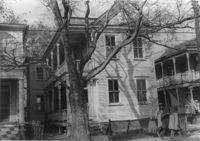
House on St. Phillip Street at the corner of Sheppard Street (corner view, rear, Sheppard Street side), on site affected by the construction of Interstate 26 (I-26). Address: 277 St. Philip Street. View of Street corner. Surveyor notations on back of photo: "Dkt.: 10.517. Property owner: George A. Castens. Tract: 93. Station: 24+00 Lt. Northbound Lane Route 17. Date: March 5, 1963. In R/W - Bought." [See collection description for explanation of surveyor notations.]
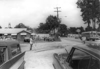
Ashley Lanes (bowling alley), on site affected by the widening of Routes 7 & 171. Surveyor notations on back of photo: "Dkt.: 10.551. Property owner: Ashley Lanes, Inc. Tract: 3. Station: 128±00 Lt. Date: Jul. 22, 1965. Looking SE from Ashley Hall Road and Rt. 7 intersection, at range poles on corners of ? area. [See collection description for explanation of surveyor notations.]
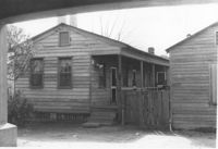
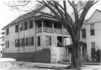
Houses on Sheppard Street (rear view) on site affected by the construction of the Crosstown. Address: 131½ Sheppard Street [131 Sheppard Street]. Surveyor notations on back of photo: "Dkt.: 10.524. Property owner: William Delestine, et al. Tract: 127. Station: 89+60 Rt. Date: Dec. 2, 1964. Proximity." [See collection description for explanation of surveyor notations.]
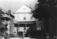
House on site affected by the construction of the Crosstown. Address: 506 Rutledge Avenue. Surveyor notations on back of photo: "Dkt.: 10.524. Property owner: Stephen B. Graham, et al. Tract: 113. Station: 86+50 Lt. Date: Dec. 1, 1964. In R/W - Bought." [See collection description for explanation of surveyor notations.]
House on site affected by the construction of the Crosstown. Address: 4 Norman Street. Surveyor notations on back of photo: "Dkt.: 10.524. Property owner: Madeline B. Allen, et al. Tract: 23. Station: 66+55 Lt. Date: Oct. 13, 1964. In R/W - Bought." [See collection description for explanation of surveyor notations.]
House on site affected by the construction of the Crosstown. Address: 2 Norman Street. Surveyor notations on back of photo: "Dkt.: 10.524. Property owner: Sadie Belle Weathers. Tract: 24. Station: 66+35 CL Lt. Date: Oct. 13, 1964. In R/W - Bought." [See collection description for explanation of surveyor notations.]
House on site affected by the construction of the Crosstown. Address: 2 Norman Street. Surveyor notations on back of photo: "Dkt.: 10.524. Property owner: Sadie Belle Weathers. Tract: 24. Station: 66+35 CL Lt. Date: Oct. 13, 1964. In R/W - Bought." [See collection description for explanation of surveyor notations.]
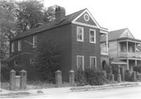
House on site affected by the construction of the Crosstown. Address: 184 Spring Street. Surveyor notations on back of photo: "Dkt.: 10.524. Property owner: Laura H. Middleton. Tract: 26. Station: 65+40 Rt. Date: Oct. 13, 1964. In R/W - Bought." [See collection description for explanation of surveyor notations.]
Lot and building (Basha's Garage) on site affected by the widening of U.S. Route 17. Posted signs for Basha's Garage. Presumably located in Mount Pleasant or vicinity. Surveyor notations on back of photo: "Dkt.: 10.439. Property owner: Ernest P. Basha, et al. Tract: 22-A. Station: 246+94 Lt. Date: Jul. 22, 1965. Looking from west at range poles on 33' & 50' R/W with trees in R/W." [See collection description for explanation of surveyor notations.]
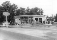
Atlantic gas station, on site affected by the widening of State Road 13 (Remount Road). Surveyor notations on back of photo: "Dkt.: 10.562. Property owner: Atlantic Refining Co. Tract: 37. Date: Jul. 19, 1967." [See collection description for explanation of surveyor notations.]
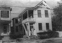
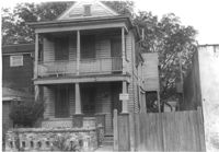
House on site affected by the construction of Interstate 26 (I-26). Address: 91-93 Sheppard Street. Appears to be a duplex. Surveyor notations on back of photo: "Dkt.: 10.517. Property owner: Elsie Hilton Mattson. Tract: 89. Station: 25+30 Lt. Northbound Lane - Route 17. Date: March 5, 1963. In R/W - Bought." [See collection description for explanation of surveyor notations.]
House on site affected by the construction of Interstate 26 (I-26). Address: 91-93 Sheppard Street. Appears to be a duplex. Surveyor notations on back of photo: "Dkt.: 10.517. Property owner: Elsie Hilton Mattson. Tract: 89. Station: 25+30 Lt. Northbound Lane - Route 17. Date: March 5, 1963. In R/W - Bought." [See collection description for explanation of surveyor notations.]
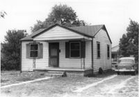
House (rear view) on site affected by the construction of Interstate 26 (I-26). Address: 2125 Montford Avenue. Surveyor notations on back of photo: "Dkt.: 10.490. Property owner: John M. Heirs. Tract: 177. Station: 100' Lt. Sta. 5886+25. Date: May 15, 1962. In R/W - Bought." [See collection description for explanation of surveyor notations.]
House on site affected by the construction of Interstate 26 (I-26). Address: 2128 Montford Avenue. Surveyor notations on back of photo: "Dkt.: 10.490. Property owner: Chas. W. Jenkins, Jr. [Charles W. Jenkins, Jr.]. Tract: 174. Station: 35' Lt. Sta. 5884+60. Date: May 15, 1962. In R/W - Bought." [See collection description for explanation of surveyor notations.]
House on site affected by the construction of Interstate 26 (I-26).Address: 2132 Montford Avenue. Surveyor notations on back of photo: "Dkt.: 10.490. Property owner: Wm. P. Mahon [William P. Mahon]. Tract: 172. Station: 5884+30 Rt. Date: May 15, 1962. In R/W - Bought." [See collection description for explanation of surveyor notations.]
House on site affected by the construction of Interstate 26 (I-26). Address: 2130 Montford Avenue. Surveyor notations on back of photo: "Dkt.: 10.490. Property owner: Rosa Lee Knight. Tract: 173. Station: 5884+50 Lt. Date: May 15, 1962. In R/W - Bought." [See collection description for explanation of surveyor notations.]
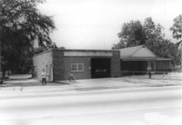
North Charleston Fire Department Station: No. 3, on site affected by the widening of State Road 13 (Remount Road). Trailer park in background. Surveyor notations on back of photo: "Dkt.: 10.562. Property owner: North Charleston Public Service. Tract: 6. Date: Jul. 12, 1967." [See collection description for explanation of surveyor notations.]
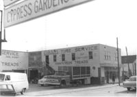
Gibson Tire Service / Hawkinson Treads on site affected by the construction of Interstate 26 (I-26). Address: 85 Lee Street. Corner of Lee Street and Meeting Street. Surveyor notations on back of photo: "Dkt.: 10.517. Property owner: Thomas P. Gibson. Tract: 59. Station: 36±00 - 37±00 Rt. & Lt. Route 17. Date: February 21, 1963. All in R/W." [See collection description for explanation of surveyor notations.]
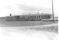
Daniel Jenkins Elementary School, on site affected by the construction of Interstate 26 (I-26). Surveyor notations on back of photo: "Dkt.: 10.490. Property owner: V.C. Chemical Co. Tract: 1. Station: 5776+00 to 5776+40 Rt. Date: September 11, 1962. To be cut off at R/W by owner." [See collection description for explanation of surveyor notations.]
Daniel Jenkins Elementary School, on site affected by the construction of Interstate 26 (I-26). Surveyor notations on back of photo: "Dkt.: 10.490. Property owner: V.C. Chemical Co. Tract: 1. Station: 5776+00 to 5776+40 Rt. Date: September 11, 1962. To be cut off at R/W by owner." [See collection description for explanation of surveyor notations.]