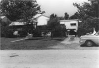
House on site affected by the construction of Interstate 26 (I-26). Surveyor notations on back of photo: "Dkt.: 10.480. Property owner: John Chaplin. Tract: 18. Station: 5503+90 Rt. Date: May 2, 1961. In R/W - Bought." [See collection description for explanation of surveyor notations.]
House on site affected by the construction of Interstate 26 (I-26). Surveyor notations on back of photo: "Dkt.: 10.480. Property owner: Paul Allen. Tract: 21. Station: 5503+80 Lt. Date: May 2, 1961. In R/W - Bought." [See collection description for explanation of surveyor notations.]
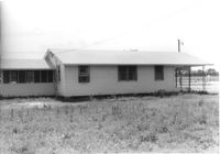
House on site affected by the construction of Interstate 26 (I-26). Building address number 107. Possibly on Rivers Avenue. Surveyor notations on back of photo: "Dkt.: 10.486. Property owner: G.F. & Beatrice C. Butler. Tract: 27. Station: 7+50 (Line E). Date: May 30, 1961. Proximity." [See collection description for explanation of surveyor notations.]
House (rear view) on site affected by the construction of Interstate 26 (I-26). Possibly on Rivers Avenue. Surveyor notations on back of photo: "Dkt.: 10.486. Property owner: M.V. & Beatrice Barrineau. Tract: 25-A. Station: 16+00 Rt. (Line C). Date: May 30, 1961. Bought." [See collection description for explanation of surveyor notations.]
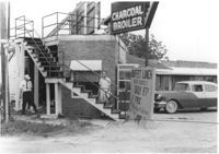
Restaurant building on site affected by the construction of Interstate 26 (I-26). Stairway and sign for Buffet Lunch in foreground. Portion of neon sign: Charcoal Broiler hangs over a phone booth. Possibly on Rivers Avenue. Surveyor notations on back of photo: "Dkt.: 10.486. Property owner: John Marcotsis, Trustee. Tract: 32. Station: 3+00 Rt. (Line F). Date: May 30, 1961. Steps to be moved. Proximity." [See collection description for explanation of surveyor notations.]
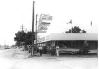
Marine Center (boat sales) on site affected by the construction of Interstate 26 (I-26). Address 4752 Rivers Avenue. View of street corner. C & R Motors in background. Possibly on Rivers Avenue. Surveyor notations on back of photo: "Dkt.: 10.486. Property owner: C.W. Keller. Tract: 33. Station: 2+75 Lt. (Line E). Date: May 30, 1961. Sign to be moved." [See collection description for explanation of surveyor notations.]
House on site affected by the construction of Interstate 26 (I-26). Neon sign for a Drive In (__MANER'S) (name partly illegible) in front, at right of photo. Possibly on Rivers Avenue. Surveyor notations on back of photo: "Dkt.: 10.486. Property owner: M.V. & Beatrice Barrineau. Tract: 25-A. Station: 16+00 Rt. (Line C). Date: May 30, 1961. Bought." [See collection description for explanation of surveyor notations.]
House (corner view, rear) on site affected by the construction of Interstate 26 (I-26). Surveyor notations on back of photo: "Dkt.: 10.480. Property owner: Willie M. Burbage. Tract: 271. Station: 5724+60 Lt. (Line C) Date: May 31, 1961. Proximity." [See collection description for explanation of surveyor notations.]
House/office (side view) on site affected by the construction of Interstate 26 (I-26). Signs "Open for Inspection" and posted office hours on front. Possibly on Rivers Avenue. Surveyor notations on back of photo: "Dkt.: 10.486. Property owner: Otis R. Burbage. Tract: 22 & 34. Station: 14+80 Rt. Date: May 30, 1961. In R/W to be moved." [See collection description for explanation of surveyor notations.]
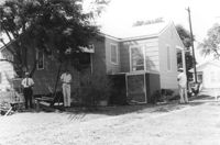
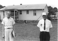
Rear view of house on site affected by the construction of Interstate 26 (I-26). Possibly on Rivers Avenue. Two DOT employees in foreground. Surveyor notations on back of photo: "Dkt.: 10.486. Property owner: Robert E. Holman. Tract: 35. Station: 11+50 Lt. (Line D). Date: May 30, 1961. Proximity." [See collection description for explanation of surveyor notations.]
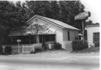
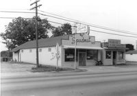
The Spudnut Shop [3646 Dorchester Road], on site affected by the construction of Interstate 26 (I-26). Front facade has stepped parapet. Neighboring building, Pick & Pay Grocery, also in photo. Surveyor notations on back of photo: "Dkt.: 10.480. Property owner: John C. Gelegotes, et al. Tract: 164. Station: 5681+50 on CL. Date: May 30, 1961. In R/W - Bought." [See collection description for explanation of surveyor notations.]
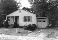
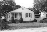
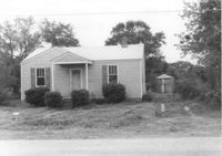
House on Dorchester Road, on site affected by the construction of Interstate 26 (I-26). Building address number 7. Surveyor notations on back of photo: "Dkt.: 10.480. Property owner: Fred M. Skipper. Tract: 179. Station: 132+90 Rt. (Route 642) [Dorchester Road]. Date: May 30, 1961. In R/W - Bought." [See collection description for explanation of surveyor notations.]
House on site affected by the construction of Interstate 26 (I-26). Partially obscured by trees. Garage (2-story) at end of driveway. Surveyor notations on back of photo: "Dkt.: 10.480. Property owner: Eugene J. Poteat. Tract: 201. Station: 5689+50 Lt. Date: May 31, 1961. In R/W - Bought." [See collection description for explanation of surveyor notations.]
House on Dorchester Road, on site affected by the construction of Interstate 26 (I-26). Building address number 7. Surveyor notations on back of photo: "Dkt.: 10.480. Property owner: Fred M. Skipper. Tract: 179. Station: 132+90 Rt. (Route 642) [Dorchester Road]. Date: May 30, 1961. In R/W - Bought." [See collection description for explanation of surveyor notations.]
House at curve in road, on site affected by the construction of Interstate 26 (I-26). Surveyor notations on back of photo: "Dkt.: 10.480. Property owner: Mrs. Hazel McSherley Barton. Tract: 185. Station: 5684+65± Rt. (Line D). Date: May 31, 1961. Damage to fence and loss of pine tree." [See collection description for explanation of surveyor notations.]
House on corner of Harvey Avenue, on site affected by the construction of Interstate 26 (I-26). Street sign for Harvey Ave. at right. Surveyor notations on back of photo: "Dkt.: 10.480. Property owner: Renkin Finance Co. Tract: 188. Station: 5686+00 Lt. Date: May 31, 1961. In R/W - Bought." [See collection description for explanation of surveyor notations.]
House on Dorchester Road, on site affected by the construction of Interstate 26 (I-26). Surveyor notations on back of photo: "Dkt.: 10.480. Property owner: Mrs. Margaret H. Patterson. Tract: 181. Station: 134+00 (Rt. (Route 642) [Dorchester Road]. Date: May 31, 1961. In R/W - Bought." [See collection description for explanation of surveyor notations.]
House on site affected by the construction of Interstate 26 (I-26). Partially obscured by trees. Surveyor notations on back of photo: "Dkt.: 10.480. Property owner: Sallie Mae Penninger. Tract: 198. Station: 5688+95 Lt. Date: May 31, 1961. In R/W - Bought." [See collection description for explanation of surveyor notations.]
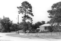
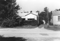
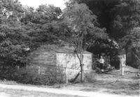
Property and structure (shed?) on Dorchester Road, on site affected by the construction of Interstate 26 (I-26). Surveyor notations on back of photo: "Dkt.: 10.480. Property owner: Mrs. Dorothy V. Bartee. Tract: 178. Station: 132+42 Rt. (Route 642) [Dorchester Road]. Date: May 30, 1961. In R/W - Bought." [See collection description for explanation of surveyor notations.]
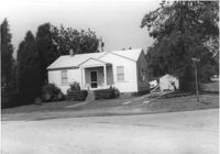
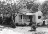
House on site affected by the construction of Interstate 26 (I-26). Building address number 191. Driveway leads to garage/shed. Surveyor notations on back of photo: "Dkt.: 10.480. Property owner: John S. Singleton. Tract: 132. Station: 5652+80 Rt. Date: May 1, 1961. In R/W - Bought." [See collection description for explanation of surveyor notations.]