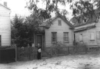
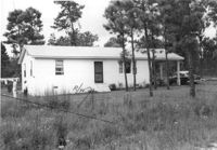
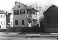
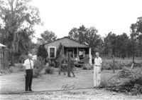
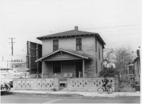
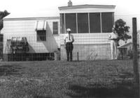
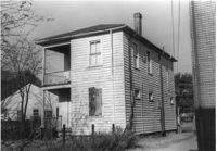
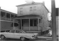
House (freedman's cottage) on site affected by the construction of the Crosstown. Address: 72 Kracke Street [note: 29 Kracke Street today]. Surveyor notations on back of photo: "Dkt.: 10.524. Property owner: Carlotta Alston. Tract: 67. Station: 76+45 Lt. Date: Oct. 14, 1964. Proximity." [See collection description for explanation of surveyor notations.]
House (freedman's cottage) on site affected by the construction of Interstate 26 (I-26). Address: 15½ Addison Street [15 Addison Street]. Surveyor notations on back of photo: "Dkt.: 10.503. Property owner: Evan Gethers, et al. Tract: 100. Station: 5919+80 Lt. Date: Feb. 20, 1963. In R/W - Bought." [See collection description for explanation of surveyor notations.]
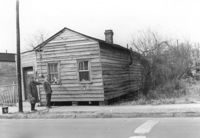
House on site affected by the construction of Interstate 26 (I-26). Sign posted in ground: Worms for sale. Surveyor notations on back of photo: "Dkt.: 10.471. Property owner: F.R. Shutt, et al. Tract: 92. Station: 5376+10 Rt. Date: Aug. 23, 1960. In R/W - Bought." [See collection description for explanation of surveyor notations.]
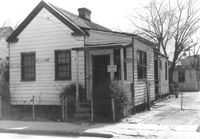
Side view of corner grocery store on site affected by the construction of the Crosstown. Address: 121 America Street. Surveyor notations on back of photo: "Dkt.: 10.518. Property owner: Vallie Talbert. Tract: 58. Station: 49+50 Lt. N.B. lane Route 17. Date: Mar. 7, 1963." [See collection description for explanation of surveyor notations.]
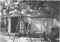
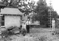
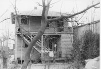
Two sheds and swing set, with standing girl, on site affected by the construction of Interstate 26 (I-26). Address: 2124 Weaver Avenue. Surveyor notations on back of photo: "Dkt.: 10.490. Property owner: Harry L. Rumph, Jr. Tract: 188. Station: 30' Lt. Sta. 5886-55. Date: May 15, 1962. In R/W - Bought." [See collection description for explanation of surveyor notations.]
House on site affected by the construction of Interstate 26 (I-26). Surveyor notations on back of photo: "Dkt.: 10.471. Property owner: W.L. McDonald, et al. Tract: 38. Station: 5326+00 Rt. Date: Aug. 23, 1960. In R/W - Bought." [See collection description for explanation of surveyor notations.]
House on site affected by the construction of Interstate 26 (I-26). Surveyor notations on back of photo: "Dkt.: 10.471. Property owner: Isabella W. Meany. Tract: 98. Station: 5378+80 Rt. Date: Aug. 23, 1960. In R/W - Bought." [See collection description for explanation of surveyor notations.]
House on site affected by the construction of Interstate 26 (I-26). Surveyor notations on back of photo: "Dkt.: 10.471. Property owner: Annie L. Beattie. Tract: 83. Station: 5364+00 Rt. Date: Aug. 23, 1960. In R/W - Bought." [See collection description for explanation of surveyor notations.]
House on site affected by the construction of Interstate 26 (I-26). Surveyor notations on back of photo: "Dkt.: 10.471. Property owner: E.T. Walling. Tract: 39. Station: 5324+30 Lt. Date: Aug. 23, 1960. In R/W - Bought." [See collection description for explanation of surveyor notations.]
House on site affected by the construction of Interstate 26 (I-26). Surveyor notations on back of photo: "Dkt.: 10.471. Property owner: J.E. Walling. Tract: 41. Station: 5325+15 Rt. Date: Aug. 23, 1960. In R/W - Bought." [See collection description for explanation of surveyor notations.]
House on site affected by the construction of Interstate 26 (I-26). Surveyor notations on back of photo: "Dkt.: 10.471. Property owner: R.B. Evans. Tract: 2. Station: 5155+75 Lt. Date: Aug. 23, 1960. Proximity." [See collection description for explanation of surveyor notations.]
Structure on site affected by the construction of the Crosstown. Address: 122 Sheppard Street. Surveyor notations on back of photo: "Dkt.: 10.524. Property owner: Archie B. Hollins. Tract: 136. Station: 17+40 Lt. S.B. lane. Date: Dec. 2, 1964. Outside R/W." [See collection description for explanation of surveyor notations.]
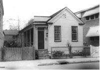
House (freedman's cottage) on site affected by the construction of the Crosstown. Address: 115 America Street. Surveyor notations on back of photo: "Dkt.: 10.518. Property owner: Jerusalem Baptist Church. Tract: 60. Station: 49+60 Rt. N.B. lane Route 17. Date: Mar. 7, 1963." [See collection description for explanation of surveyor notations.]
Rear view of house on site affected by the construction of the Crosstown. Address: 5 Rosemont Street. Backyard strewn with wood boards, etc. Surveyor notations on back of photo: "Dkt.: 10.524. Property owner: Harold I. Sherman. Tract: 53. Station: 71+20 Rt. Date: Oct. 14, 1964. Portion in R/W already torn down by property owner." [See collection description for explanation of surveyor notations.]
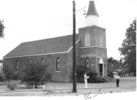
Mid Park Methodist Church, on site affected by the construction of Interstate 26 (I-26). Surveyor notations on back of photo: "Dkt.: 10.471. Property owner: Mid Park Meth. Church. Tract: 102. Station: 5376+50 Rt. Date: Aug. 23, 1960. Proximity." [See collection description for explanation of surveyor notations.]
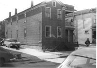
House (and neighboring buildings) on site affected by the construction of the Crosstown. Address: 60-58 Aiken Street. Public Telephone sign in foreground. Surveyor notations on back of photo: "Dkt.: 10.518. Property owner: Congaree Jenkins, Est. Tract: 54. Station: 48+00 Rt. N.B. lane Route 17. Date: Mar. 7, 1963." [See collection description for explanation of surveyor notations.]
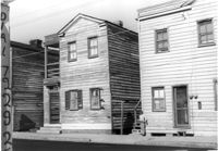
House on site affected by the construction of the Crosstown. Address: 68 Cooper Street. (Number on building is 78.) Surveyor notations on back of photo: "Dkt.: 10.518. Property owner: Ester Bosser. Tract: 42. Station: 44+65 Rt. line 9 north of Cooper Street. Date: Mar. 6, 1963. In R/W - Bought. [See collection description for explanation of surveyor notations.]
House on site affected by construction of the Crosstown. Address: 68 Cooper Street. (Number on building is 78.) Surveyor notations on back of photo: "Dkt.: 10.518. Property owner: Ester Bosser. Tract: 42. Station: 44+65 Rt. line 9 north of Cooper Street. Date: Mar. 6, 1963. In R/W - Bought. [See collection description for explanation of surveyor notations.]
House on site affected by the construction of the Crosstown. Address: 59 Lee Street (corner of Lee Street and Hanover Street). Surveyor notations on back of photo: "Dkt.: 10.518. Property owner: Melvin Whaley. Tract: 40. Station: 44+35 Rt. S.B. lane Route 17. Date: Mar. 6, 1963. In R/W - Bought. [See collection description for explanation of surveyor notations.]
House on site affected by the construction of the Crosstown. Address: 88 Hanover Street. Surveyor notations on back of photo: "Dkt.: 10.518. Property owner: Jerusalem Baptist Church. Tract: 43. Station: 43+90 CL line 9 north of Cooper Street. Date: Mar. 6, 1963." [See collection description for explanation of surveyor notations.]
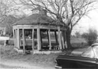
Gazebo, on site affected by the widening of Route 171 (Folly Road). Surveyor notations on back of photo: "Dkt.: 10.494. Property owner: Sophie Sabel, Est. Tract: 97. Station: 370+50 Lt. Date: Mar. 21, 1962. In R/W - Bought. [See collection description for explanation of surveyor notations.]
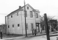
House (corner view, rear) on site affected by the construction of Interstate 26 (I-26). Address: 518½ Meeting Street. Wooden fence in foreground. Surveyor notations on back of photo: "Dkt.: 10.517. Property owner: Mrs. Bessie Rosen. Tract: 60. Station: 5959+80 CL - Line 6. Date: March 5, 1963. In R/W - Bought." [See collection description for explanation of surveyor notations.]
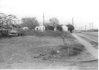
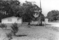
Lot on Spruill Avenue, on site affected by the construction of Interstate 26 (I-26). Houses in background. Surveyor notations on back of photo: "Dkt.: 10.490. Property owner: E.C. Brown. Tract: 28-A. Station: 51+50 Rt. (Spruill Ave.). Date: November 4, 1965. General view of land located in radius at intersection of Spruill Ave. and I-26. Line 'A'." [See collection description for explanation of surveyor notations.]
House on site affected by the construction of Interstate 26 (I-26). Building address number 22 (painted on mailbox). Surveyor notations on back of photo: "Dkt.: 10.471. Property owner: Eleanor L. O'Brien. Tract: 105. Station: 5379+50 Lt. Date: Aug. 23, 1960. Proximity." [See collection description for explanation of surveyor notations.]
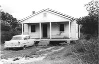
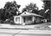
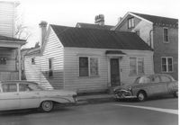
House on site affected by the widening of U.S. Route 17. Presumably located in Mount Pleasant or vicinity. Surveyor notations on back of photo: "Dkt.: 10.597. Property owner: Julia B. Simmons. Tract: 54. Station: 301+00 Lt. Date: Sept. 17, 1968." [See collection description for explanation of surveyor notations.]
House, and Fuller's Grocery, on site affected by the construction of Interstate 26 (I-26). Surveyor notations on back of photo: "Dkt.: 10.471. Property owner: H.L. Fuller. Tract: 103. Station: 28+00 Lt. (Midland Park Road). Date: Aug. 23, 1960. Proximity." [See collection description for explanation of surveyor notations.]
House on site affected by the construction of Interstate 26 (I-26). Surveyor notations on back of photo: "Dkt.: 10.471. Property owner: Katie S. Smith. Tract: 37. Station: 5323+80 Lt. Date: Aug. 23, 1960. In R/W - Bought." [See collection description for explanation of surveyor notations.]
House on site affected by the construction of Interstate 26 (I-26). Surveyor notations on back of photo: "Dkt.: 10.471. Property owner: Mamie W. Brown. Tract: 91. Station: 5376+15 Rt. Date: Aug. 23, 1960. In R/W - Bought." [See collection description for explanation of surveyor notations.]
House on site affected by the construction of Interstate 26 (I-26). Surveyor notations on back of photo: "Dkt.: 10.471. Property owner: M.L. Shipman, et al. Tract: 42. Station: 5326+75 Rt. Date: Aug. 23, 1960. Proximity." [See collection description for explanation of surveyor notations.]
House on site affected by the construction of Interstate 26 (I-26). Surveyor notations on back of photo: "Dkt.: 10.471. Property owner: W.W. Gregory. Tract: 46. Station: 5329+60 Rt. Date: Aug. 23, 1960. Proximity." [See collection description for explanation of surveyor notations.]
House (freedman's cottage) on site affected by the construction of the Crosstown. Address: 118 Bogard Street. Surveyor notations on back of photo: "Dkt.: 10.524. Property owner: Marion Holmes Wright, Est., et al. Tract: 62. Station: 75+10 CL Lt. Date: Oct. 14, 1964. Partially in R/W." [See collection description for explanation of surveyor notations.]
House on Spruill Avenue on site affected by the construction of Interstate 26 (I-26). [Intersection of Hugo Avenue.] Surveyor notations on back of photo: "Dkt.: 10.490. Property owner: Julia M. Pritchard. Tract: 28-B. Station: 48+80 Rt. (Spruill Ave.) Date: November 4, 1965. Range poles on new R/W. Building partially in R/W." [See collection description for explanation of surveyor notations.]
House on site affected by the construction of Interstate 26 (I-26). Address: 86 Cooper Street. Shell gas station (previous photo) in background. Surveyor notations on back of photo: "Dkt.: 10.517. Property owner: Nellie T. France. Tract: 62. Station: 5961+60 Rt. - Line 6. Date: March 5, 1963. In R/W - Bought." [See collection description for explanation of surveyor notations.]
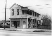
Infinger's Shoe Service on site affected by the construction of Interstate 26 (I-26). Address: 508 Meeting Street. Surveyor notations on back of photo: "Dkt.: 10.517. Property owner: Pandora Co. Tract: 63. Station: 5963+00 CL - Line 6. Date: March 5, 1963. Partially in R/W." [See collection description for explanation of surveyor notations.]
House (rear view) on site affected by the construction of Interstate 26 (I-26). Address: 86 Cooper Street. Surveyor notations on back of photo: "Dkt.: 10.517. Property owner: Nellie T. France. Tract: 62. Station: 5961+60 Rt. - Line 6. Date: March 5, 1963. In R/W - Bought." [See collection description for explanation of surveyor notations.]
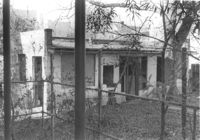
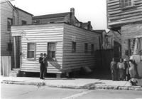
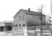
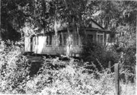
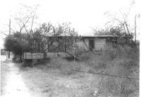
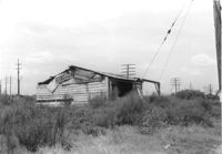
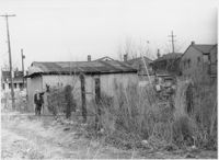
Dilapidated wood-sided structure on site affected by the construction of Interstate 26 (I-26). On grounds with many power lines on property. On Meeting Street/Meeting Street Road Surveyor notations on back of photo: "Dkt.: 10.510. Property owner: Geo. Fabian, Jr. Tract: 67. Station: 5796+10 on CL Lt. (Meeting Street). Date: Sept. 12, 1962. In R/W - Bought." [See collection description for explanation of surveyor notations.]
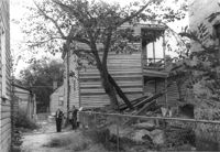
House (rear view) on site affected by the construction of Interstate 26 (I-26). [Building address number 145.] Surveyor notations on back of photo: "Dkt.: 10.480. Property owner: Jerome M. Williams. Tract: 270. Station: 5724+10 Lt. (Line C). Date: May 31, 1961. Proximity." [See collection description for explanation of surveyor notations.]
House on or in vicinity of King Street Extn., on site affected by the construction of Interstate 26 (I-26). Surveyor notations on back of photo: "Dkt.: 10.490. Property owner: V.C. Chemical Co. Tract: 1. Station: 5808+00 Lt. (Line F). Date: September 11, 1962. Partially in R/W." [See collection description for explanation of surveyor notations.]
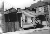
Wooden structure (shed or garage?) (rear view) on site affected by the construction of Interstate 26 (I-26). Address: 23 Jacobs Court. Surveyor notations on back of photo: "Dkt.: 10.517. Property owner: Furman G. Owens. Tract: 60-B. Station: 40+00 Lt. Northbound Lane, 5960+40 Lt. - Line 6. Date: March 5, 1963. In R/W - Bought." [See collection description for explanation of surveyor notations.]
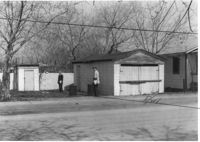
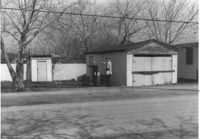
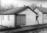
Garage and shed on site affected by the construction of Interstate 26 (I-26). Surveyor notations on back of photo: "Dkt.: 10.490. Property owner: Mostester Brown [Mostester Brown?]. Tract: 87-C. Station: 5825+45 Rt. Date: March 22, 1962. In R/W - Bought." [See collection description for explanation of surveyor notations.]
Garage and shed on site affected by the construction of Interstate 26 (I-26). Surveyor notations on back of photo: "Dkt.: 10.490. Property owner: Mostester Brown [Montester Brown?]. Tract: 87-C. Station: 5825+45 Rt. [Undated.] In R/W - Bought." [See collection description for explanation of surveyor notations.]
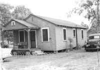
House on site affected by the construction of Interstate 26 (I-26). Possibly on Rivers Avenue. Surveyor notations on back of photo: "Dkt.: 10.486. Property owner: Ernest E. & Nolie C. Grooms. Williams Furniture Corp. Tract: 41. Station: 29+40 Lt. Date: May 30, 1961. In R/W - Bought." [See collection description for explanation of surveyor notations.]
House (corner view, rear) on site affected by the construction of Interstate 26 (I-26). Possibly on Rivers Avenue. Surveyor notations on back of photo: "Dkt.: 10.486. Property owner: Mrs. Mertice S. Greenhill. Tract: 26. Station: 8+50 Lt. (Line E). Date: May 30, 1961. In R/W - Bought." [See collection description for explanation of surveyor notations.]
House on Sheppard Street (rear view) on site affected by the construction of the Crosstown. Address: 137 Sheppard Street. Surveyor notations on back of photo: "Dkt.: 10.524. Property owner: Frank Williams. Tract: 126. Station: 89+40 Lt. Date: Dec. 2, 1964. In R/W - Bought." [See collection description for explanation of surveyor notations.]
House on Sheppard Street on site affected by the construction of the Crosstown. Address: 135 Sheppard Street. Surveyor notations on back of photo: "Dkt.: 10.524. Property owner: William Delestine, et al. Tract: 127. Station: 89+80 CL. Date: Dec. 2, 1964. In R/W - Bought." [See collection description for explanation of surveyor notations.]
House on site affected by the construction of the Crosstown. Address: 139 Sheppard Street. Surveyor notations on back of photo: "Dkt.: 10.524. Property owner: Wilmot J. Frasier. Tract: 125. Station: 89+15 Lt. Date: Dec. 2, 1964. In R/W - Bought." [See collection description for explanation of surveyor notations.]
House on site affected by the construction of the Crosstown. Address: 139 Sheppard Street. Surveyor notations on back of photo: "Dkt.: 10.524. Property owner: Wilmot J. Frasier. Tract: 125. Station: 89+15 Lt. Date: Dec. 2, 1964. In R/W - Bought." [See collection description for explanation of surveyor notations.]
House on Sheppard Street on site affected by the construction of the Crosstown. Address: 137 Sheppard Street. Surveyor notations on back of photo: "Dkt.: 10.524. Property owner: Frank Williams. Tract: 126. Station: 89+40 Lt. Date: Dec. 2, 1964. In R/W - Bought." [See collection description for explanation of surveyor notations.]
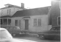
Lot and house (side view) on site affected by the widening of U.S. Route 17. Posted sign says: Edna's Ceramic Chop: Greenware, supplies, firing, lessons. Presumably located in Mount Pleasant or vicinity. Surveyor notations on back of photo: "Dkt.: 10.439. Property owner: Doretha B. Chavis. Tract: 15. Station: 224+51 to 225+51 Lt. Date: Jul. 22, 1965. Proximity." [See collection description for explanation of surveyor notations.]
Shed (railroad building) along railroad tracks, on site affected by the construction of Interstate 26 (I-26). Address: 19½ Poinsett Street (rear). Surveyor notations on back of photo: "Dkt.: 10.503. Property owner: S.A.L.R.R. Tract: 105. Station: 5924+35 Rt. & Lt. Date: Feb. 20, 1963." [See collection description for explanation of surveyor notations.]