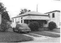
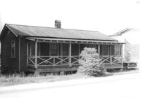
House on site affected by the construction of Interstate 26 (I-26). Surveyor notations on back of photo: "Dkt.: 10.490. Property owner: Geo. L. Robertson [George L. Robertson]. Tract: 87. Station: 5825+30 Rt. Date: May 15, 1962. In R/W - Bought." [See collection description for explanation of surveyor notations.]
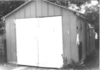
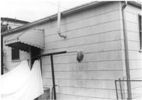
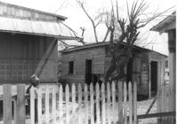
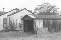
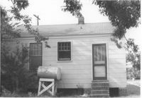
Shed on site affected by the construction of Interstate 26 (I-26). Address: 2133 Weaver Avenue. Surveyor notations on back of photo: "Dkt.: 10.490. Property owner: Arthur P. Jones. Tract: 199. Station: 5889+25 Rt. Date: May 15, 1962. In R/W - Bought." [See collection description for explanation of surveyor notations.]
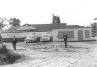
H.W. Halter Cheese Butter Oleo Poultry Eggs [company], on site affected by the widening of Route 171 (Folly Road). Surveyor notations on back of photo: "Dkt.: 10.494. Property owner: H.W. Halter, et al. Tract: 78. Station: 209+20 Rt. Date: Mar. 21, 1962. Proximity. Loss of parking space. [See collection description for explanation of surveyor notations.]
House (rear view) on site affected by the construction of Interstate 26 (I-26). Address: 2139 Weaver Avenue. Surveyor notations on back of photo: "Dkt.: 10.490. Property owner: Archie L. Moore. Tract: 198. Station: 65' Rt. Sta. 5889+40. Date: May 15, 1962. In R/W - Bought." [See collection description for explanation of surveyor notations.]
Charleston Plywood & Lumber Co. building (side view) on site affected by the construction of Interstate 26 (I-26). Surveyor notations on back of photo: "Dkt.: 10.490. Property owner: Kurco, Inc. Tract: 120, 121, 124 through 140-A and 133 through 133. Station: 5831+35 Rt. Date: August 29, 1962. Part in R/W to be moved by SCHD {SC Highway Department]." [See collection description for explanation of surveyor notations.]
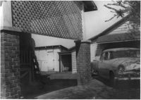
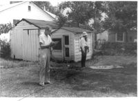
View through brick columns of shed and neighboring house, on site affected by the construction of Interstate 26 (I-26). [Address 2208 Delano.] Surveyor notations on back of photo: "Dkt.: 10.490. Property owner: Geo. F. Garner [George F. Garner]. Tract: 78. Station: 5822+40-5822+80 Rt. Date: March 22, 1962. In R/W - Bought." [See collection description for explanation of surveyor notations.]
House (rear view) on site affected by the construction of Interstate 26 (I-26). Address: 2133 Weaver Avenue. Surveyor notations on back of photo: "Dkt.: 10.490. Property owner: Arthur P. Jones. Tract: 199. Station: 5889+70 Rt. Date: May 15, 1962. In R/W - Bought." [See collection description for explanation of surveyor notations.]
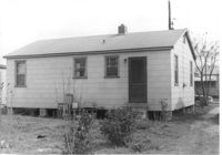
House on site affected by the construction of Interstate 26 (I-26).Address: 2139 Weaver Avenue. Surveyor notations on back of photo: "Dkt.: 10.490. Property owner: Archie L. Moore. Tract: 198. Station: 65' Rt. Sta. 5889+40. Date: May 15, 1962. In R/W - Bought." [See collection description for explanation of surveyor notations.]
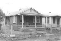
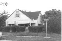
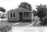
House on site affected by the construction of Interstate 26 (I-26). Building address number 2220. Surveyor notations on back of photo: "Dkt.: 10.490. Property owner: W.L. Gaillard, et al. Tract: 102. Station: 5827+85 Lt. Date: March 22, 1962. In R/W - Bought." [See collection description for explanation of surveyor notations.]
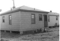
House on site affected by the construction of Interstate 26 (I-26). Address: 2133 Weaver Avenue. Surveyor notations on back of photo: "Dkt.: 10.490. Property owner: Arthur P. Jones. Tract: 199. Station: 5889+70 Rt. Date: May 15, 1962. In R/W - Bought." [See collection description for explanation of surveyor notations.]
House (portion, rear view) and shed on site affected by the construction of Interstate 26 (I-26). Surveyor notations on back of photo: "Dkt.: 10.490. Property owner: Minnie R. Sherman. Tract: 91. Station: 5826+70 Lt. Date: March 22, 1962. In R/W - Bought." [See collection description for explanation of surveyor notations.]
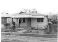
House (corner view, rear) on site affected by the construction of Interstate 26 (I-26). Surveyor notations on back of photo: "Dkt.: 10.490. Property owner: Harold C. Parrish. Tract: 90-A. Station: 5825+40 Lt. Date: March 22, 1962. In R/W - Bought." [See collection description for explanation of surveyor notations.]
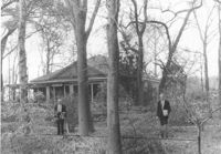
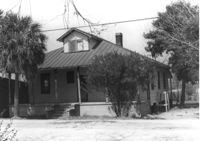
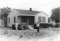
House named "Shady Grove," on site affected by the widening of Route 171 (Folly Road). Surveyor notations on back of photo: "Dkt.: 10.494. Property owner: Mrs. Martha A. Gibson. Tract: 72. Station: 279+80 Rt. Date: Mar. 21, 1962. Proximity. [See collection description for explanation of surveyor notations.]
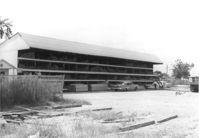
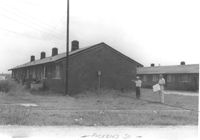
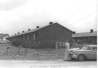
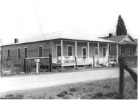
Multi-family housing on Pickens Street (307 Pickens Street), on site affected by the construction of Interstate 26 (I-26). Surveyor notations on back of photo: "Dkt.: 10.490. Property owner: Ashley Development Co. Tract: 1-A. Station: 5771+90 to 5772+90 Rt. Date: September 11, 1962. To be cut off at R/W by owner." [See collection description for explanation of surveyor notations.]
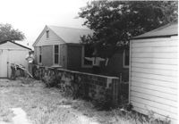
House (rear view) yard, and shed, on site affected by the construction of Interstate 26 (I-26). [Building address number 2202]. Surveyor notations on back of photo: "Dkt.: 10.490. Property owner: Julius A. Cercoply. Tract: 17. Station: 5818+20 Lt. Date: March 22, 1962. In R/W - Bought." [See collection description for explanation of surveyor notations.]
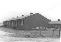
Multi-family housing on Pickens Street (301 Pickens Street), on site affected by the construction of Interstate 26 (I-26). Surveyor notations on back of photo: "Dkt.: 10.490. Property owner: Ashley Development Co. Tract: 1-A. Station: 5772+19 to 5773+80 Lt. Date: September 11, 1962. In R/W - Bought." [See collection description for explanation of surveyor notations.]
House (rear view) and yard on site affected by the construction of Interstate 26 (I-26). Surveyor notations on back of photo: "Dkt.: 10.490. Property owner: Lottie M. Heinsohn. Tract: 91-A. Station: 5826+70 Lt. Date: March 22, 1962. Proximity." [See collection description for explanation of surveyor notations.]
House (rear view) on site affected by the construction of Interstate 26 (I-26). Surveyor notations on back of photo: "Dkt.: 10.490. Property owner: W.L. Gaillard, et al. Tract: 99. Station: 5827+75 Rt. Date: March 22, 1962. In R/W - Bought." [See collection description for explanation of surveyor notations.]
House (rear view) on site affected by the construction of Interstate 26 (I-26). Surveyor notations on back of photo: "Dkt.: 10.490. Property owner: W.L. Gaillard, et al. Tract: 98. Station: 5827+75 Rt. Date: March 22, 1962. In R/W - Bought." [See collection description for explanation of surveyor notations.]
House on site affected by the construction of Interstate 26 (I-26). Surveyor notations on back of photo: "Dkt.: 10.490. Property owner: H.T. Sturken, et al. Tract: 89. Station: 5825+40 Lt. Date: March 22, 1962. In R/W - Bought." [See collection description for explanation of surveyor notations.]
Multi-family housing on Pickens Street (305 Pickens Street), on site affected by the construction of Interstate 26 (I-26). Surveyor notations on back of photo: "Dkt.: 10.490. Property owner: Ashley Development Co. Tract: 1-A. Station: 5771+90 to 5772+90 Rt. Date: September 11, 1962. In R/W - Bought." [See collection description for explanation of surveyor notations.]
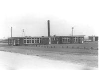
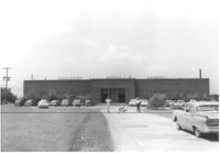
Daniel Jenkins Elementary School, on site affected by the construction of Interstate 26 (I-26). Surveyor notations on back of photo: "Dkt.: 10.490. Property owner: V.C. Chemical Co. Tract: 1. Station: 5775+65 to 5776+60 Lt. Date: September 11, 1962. In R/W - Bought." [See collection description for explanation of surveyor notations.]
Garage or shed and house (rear view) on site affected by the construction of Interstate 26 (I-26). Address: 2136 Courtland Avenue. Surveyor notations on back of photo: "Dkt.: 10.490. Property owner: Leo Zack. Tract: 159. Station: 5881±80 Rt. Date: August 29, 1962. In R/W - Bought." [See collection description for explanation of surveyor notations.]
Garage on site affected by the construction of Interstate 26 (I-26). Address: 2127 Courtland Avenue. Surveyor notations on back of photo: "Dkt.: 10.490. Property owner: Geo. L. Johnson [George L. Johnson]. Tract: 162. Station: 5883±90 Lt. Date: August 29, 1962. Portion In R/W - Bought." [See collection description for explanation of surveyor notations.]
House and garage (at end of driveway), on site affected by the construction of Interstate 26 (I-26). Address: 2127 Courtland Avenue. Surveyor notations on back of photo: "Dkt.: 10.490. Property owner: Geo. L. Johnson [George L. Johnson]. Tract: 162. Station: 5883±70 Lt. Date: August 29, 1962. Proximity." [See collection description for explanation of surveyor notations.]
House at corner of Rutledge Avenue and Courtland Avenue, on site affected by the construction of Interstate 26 (I-26). Address: 1336 Rutledge Avenue. Surveyor notations on back of photo: "Dkt.: 10.490. Property owner: Annie E. Kirby. Tract: 158. Station: 5881+90 Rt. Date: August 29, 1962. In R/W - Bought." [See collection description for explanation of surveyor notations.]
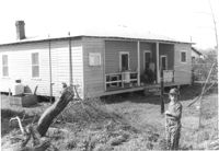
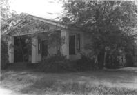
House (rear view) on site affected by the construction of Interstate 26 (I-26). Address: 2 Carters Court. Surveyor notations on back of photo: "Dkt.: 10.490. Property owner: Louise S. Carter. Tract: 150. Station: 25' Lt. Sta. 5880+55. Date: May 15, 1962. In R/W - Bought." [See collection description for explanation of surveyor notations.]
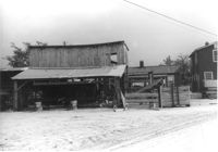
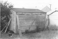
Storage structure on site affected by the construction of Interstate 26 (I-26). Address: Heriot Street. Presumably part of lumber yard. Surveyor notations on back of photo: "Dkt.: 10.490. Property owner: G.S. Carter & Son., Inc. Tract: 143. Station: 5878±. Date: August 29, 1962. In R/W - Bought." [See collection description for explanation of surveyor notations.]
House (rear view) on site affected by the construction of Interstate 26 (I-26). Address: 2170 Heriot Street. Possibly residence of lumber yard employee. Stacks of lumber at side of house and in foreground. Surveyor notations on back of photo: "Dkt.: 10.490. Property owner: G.S. Carter & Son., Inc. Tract: 143. Station: 5878±. Date: August 29, 1962. In R/W - Bought." [See collection description for explanation of surveyor notations.]
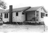
House on site affected by the construction of Interstate 26 (I-26). Address: 2170 Heriot Street. Possibly residence of lumber yard employee. Surveyor notations on back of photo: "Dkt.: 10.490. Property owner: G.S. Carter & Son., Inc. Tract: 143. Station: 5878±. Date: August 29, 1962. In R/W - Bought." [See collection description for explanation of surveyor notations.]
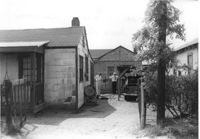
House (partial view) and structure at end of driveway, on site affected by the construction of Interstate 26 (I-26). Surveyor notations on back of photo: "Dkt.: 10.490. Property owner: Sadie Gilliard, et al. Tract: 138-D. Station: 5858+80 Lt. Date: May 15, 1962. Proximity." [See collection description for explanation of surveyor notations.]
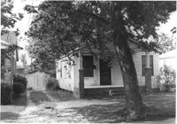
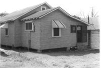
House (side view) on site affected by the construction of Interstate 26 (I-26). Surveyor notations on back of photo: "Dkt.: 10.490. Property owner: Margaret Ehrardt. Tract: 24. Station: 5820+55 Rt. Line "G." Date: March 22, 1962. In R/W - Bought." [See collection description for explanation of surveyor notations.]
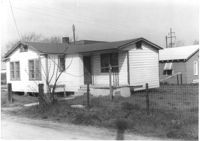
House on site affected by the construction of Interstate 26 (I-26). Surveyor notations on back of photo: "Dkt.: 10.490. Property owner: James and Joseph Davis. Tract: 25. Station: 5820+50 Lt. Line "G." Date: March 22, 1962. In R/W - Bought." [See collection description for explanation of surveyor notations.]
House (rear view) on site affected by the construction of Interstate 26 (I-26). Surveyor notations on back of photo: "Dkt.: 10.490. Property owner: Ruth V. Cooper. Tract: 26. Station: 5820+50 on CL. Date: March 22, 1962. In R/W - Bought." [See collection description for explanation of surveyor notations.]
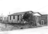
House on site affected by the construction of Interstate 26 (I-26). Surveyor notations on back of photo: "Dkt.: 10.490. Property owner: Ruth V. Cooper. Tract: 26. Station: 5820+50 on CL. Date: March 22, 1962. In R/W - Bought." [See collection description for explanation of surveyor notations.]
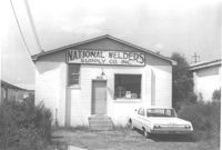
National Welders Supply Co. Inc. building, on site affected by the construction of Interstate 26 (I-26). Building address number 1858. Surveyor notations on back of photo: "Dkt.: 10.490. Property owner: Minnie R. Sherman. Tract: 115 and 118. Station: 5829+80 Lt. Date: August 29, 1962." [See collection description for explanation of surveyor notations.]
Shed on site affected by the construction of Interstate 26 (I-26). Address: 2136 Montford Avenue. Surveyor notations on back of photo: "Dkt.: 10.490. Property owner: Werner R. Mohrmann. Tract: 170. Station: 5884 ±20 Rt. Date: August 29, 1962. In R/W - Bought." [See collection description for explanation of surveyor notations.]
Portion of lot, brick wall, and house (rear view) on site affected by the construction of Interstate 26 (I-26). Address: 1332 Rutledge Avenue. Surveyor notations on back of photo: "Dkt.: 10.490. Property owner: Cornelia B. Orvin. Tract: 169. Station: 100' Rt. Sta. 5883+25. Date: May 15, 1962. Owner to clear R/W." [See collection description for explanation of surveyor notations.]
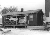
Sheds on site affected by the construction of Interstate 26 (I-26). Address: 1334 Rutledge Avenue. Surveyor notations on back of photo: "Dkt.: 10.490. Property owner: Heyward Barnes. Tract: 168. Station: 85' Rt. Sta. 5882+90. Date: May 15, 1962. In R/W - Bought." [See collection description for explanation of surveyor notations.]
House and shed at end of driveway on site affected by the construction of Interstate 26 (I-26). Address: 2135 Courtland Avenue. Surveyor notations on back of photo: "Dkt.: 10.490. Property owner: W.H. Smith, Jr. Tract: 166. Station: 5883+25 Rt. Date: May 15, 1962. In R/W - Bought." [See collection description for explanation of surveyor notations.]
House (rear view) on site affected by the construction of Interstate 26 (I-26). Address: 2130 Courtland Avenue. Surveyor notations on back of photo: "Dkt.: 10.490. Property owner: Margaret Walker. Tract: 160. Station: 5881±80 Lt. Date: August 29, 1962. In R/W - Bought." [See collection description for explanation of surveyor notations.]
House (rear view) on site affected by the construction of Interstate 26 (I-26). Address: 2129 Courtland Avenue. Surveyor notations on back of photo: "Dkt.: 10.490. Property owner: The Beach Co. Tract: 163. Station: 5883±50 Lt. Date: August 29, 1962. In R/W - Bought." [See collection description for explanation of surveyor notations.]
House on site affected by the construction of Interstate 26 (I-26). Address: 2128 Courtland Avenue. Surveyor notations on back of photo: "Dkt.: 10.490. Property owner: George DeVore, et al. Tract: 161. Station: 100' Lt. Sta. 5882+30. Date: May 15, 1962. Proximity." [See collection description for explanation of surveyor notations.]
House on site affected by the construction of Interstate 26 (I-26). Address: 2132 Courtland Avenue. Surveyor notations on back of photo: "Dkt.: 10.490. Property owner: Margaret Walker. Tract: 160. Station: 5881±80 Lt. Date: August 29, 1962. In R/W - Bought." [See collection description for explanation of surveyor notations.]
Charleston Plywood & Lumber Co. building (side view) on site affected by the construction of Interstate 26 (I-26). Surveyor notations on back of photo: "Dkt.: 10.490. Property owner: Kurco, Inc. Tract: 120, 121, 124 through 140-A and 133 through 133. Station: 5832+30 Rt. Date: August 29, 1962." [See collection description for explanation of surveyor notations.]
House on or in vicinity of King Street Extn., on site affected by the construction of Interstate 26 (I-26). Surveyor notations on back of photo: "Dkt.: 10.490. Property owner: V.C. Chemical Co. Tract: 1. Station: 5810+10 Lt. (Line F). Date: September 11, 1962. Partially in R/W." [See collection description for explanation of surveyor notations.]
House on or in vicinity of King Street Extn., on site affected by the construction of Interstate 26 (I-26). Surveyor notations on back of photo: "Dkt.: 10.490. Property owner: V.C. Chemical Co. Tract: 1. Station: 5809+10 Lt. (Line F). Date: September 11, 1962. In R/W - Bought." [See collection description for explanation of surveyor notations.]
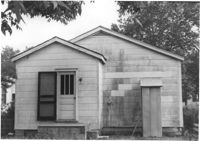
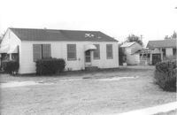
House on site affected by the construction of Interstate 26 (I-26). Building address number 2224. Surveyor notations on back of photo: "Dkt.: 10.490. Property owner: Mary Jane Graham. Tract: 103-A. Station: 5827+90 Lt. Date: March 22, 1962. Owner to clear R/W." [See collection description for explanation of surveyor notations.]
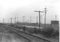
Virginia-Carolina Chemical Corp. property with railroad tracks and utility poles, on site affected by the construction of Interstate 26 (I-26). On or in vicinity of King Street Extn. Billboard for Miller High Life beer on property. Surveyor notations on back of photo: "Dkt.: 10.490. Property owner: V.C. Chemical Co. Tract: 1. Date: September 11, 1962. Panoramic view of VC Chemical Complex. Taken from north side. (See plans for location.) (For information only.)" [See collection description for explanation of surveyor notations.]
Charleston Supply Company building on site affected by the construction of Interstate 26 (I-26). Surveyor notations on back of photo: "Dkt.: 10.490. Property owner: Commercial Realty Co. Tract: 135. Station: 5837+90 Rt. Date: August 29, 1962. Proximity." [See collection description for explanation of surveyor notations.]