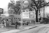
Shell gas station on site affected by the construction of Interstate 26 (I-26). Address: 1227 King Street. Surveyor notations on back of photo: "Dkt.: 10.503. Property owner: Shell Oil Co. Tract: 14-A. Station: 5893+80 Lt. Date: Feb. 19, 1963." [See collection description for explanation of surveyor notations.]
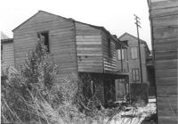
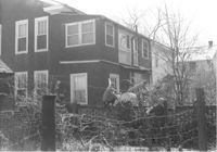
Houses (rear view) on site affected by the construction of the Crosstown. Address: 74½ Cooper Street [74 Cooper Street]. Surveyor notations on back of photo: "Dkt.: 10.518. Property owner: Beatrice Hayward. Tract: 12. Station: 5965+30 Rt. Line 3, S.B. lane of Route 17. Date: Mar. 6, 1963. In R/W - Bought. [See collection description for explanation of surveyor notations.]
House on site by the construction of Interstate 26 (I-26). Address: 1215 King Street. Surveyor notations on back of photo: "Dkt.: 10.503. Property owner: Mary M.J. Clifton. Tract: 15. Station: 5894+60 Lt. Date: Feb. 19, 1963. In R/W - Bought." [See collection description for explanation of surveyor notations.]
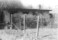
Garage on site by the construction of Interstate 26 (I-26). Address: 1215 King Street. Surveyor notations on back of photo: "Dkt.: 10.503. Property owner: Mary M.J. Clifton. Tract: 15. Station: 5894+05 Lt. Date: Feb. 19, 1963. In R/W - Bought." [See collection description for explanation of surveyor notations.]
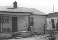
House (rear view) on site by the construction of Interstate 26 (I-26). Address: 1215 King Street. Surveyor notations on back of photo: "Dkt.: 10.503. Property owner: Mary M.J. Clifton. Tract: 15. Station: 5894+60 Lt. Date: Feb. 19, 1963. In R/W - Bought." [See collection description for explanation of surveyor notations.]
House (rear view) on site by the construction of Interstate 26 (I-26). Address: 1213 King Street. Surveyor notations on back of photo: "Dkt.: 10.503. Property owner: Robert C. Benke, et al. Tract: 16. Station: 5894+90 Lt. Date: Feb. 19, 1963. In R/W - Bought." [See collection description for explanation of surveyor notations.]
Houses on site affected by the construction of the Crosstown. Address: 73 Cooper Street. Surveyor notations on back of photo: "Dkt.: 10.518. Property owner: Centeur Corp. Tract: 13. Station: 5963+90 Rt. Line 3 of the S.B. lane of Route 17. Date: Mar. 6, 1963. Proximity. [See collection description for explanation of surveyor notations.]
House on site by the construction of Interstate 26 (I-26). Address: 1213 King Street. Surveyor notations on back of photo: "Dkt.: 10.503. Property owner: Robert C. Benke, et al. Tract: 16. Station: 5894+90 Lt. Date: Feb. 19, 1963. In R/W - Bought." [See collection description for explanation of surveyor notations.]
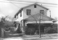
House on site by the construction of Interstate 26 (I-26). Address: 1211 King Street. Surveyor notations on back of photo: "Dkt.: 10.503. Property owner: Albert M. Jones, et al. Tract: 17. Station: 5895+00 Lt. Date: Feb. 19, 1963. In R/W - Bought." [See collection description for explanation of surveyor notations.]
House (rear view) on site by the construction of Interstate 26 (I-26). Address: 1211 King Street. Surveyor notations on back of photo: "Dkt.: 10.503. Property owner: Albert M. Jones, et al. Tract: 17. Station: 5895+00 Lt. Date: Feb. 19, 1963. In R/W - Bought." [See collection description for explanation of surveyor notations.]
House (rear view) on site by the construction of Interstate 26 (I-26). Address: 1211 King Street (rear). Surveyor notations on back of photo: "Dkt.: 10.503. Property owner: Albert M. Jones, et al. Tract: 17. Station: 5894+75 Lt. Date: Feb. 19, 1963. In R/W - Bought." [See collection description for explanation of surveyor notations.]
House (rear view) on site by the construction of Interstate 26 (I-26). Address: 1211 King Street (rear). Surveyor notations on back of photo: "Dkt.: 10.503. Property owner: Albert M. Jones, et al. Tract: 17. Station: 5894+75 Lt. Date: Feb. 19, 1963. In R/W - Bought." [See collection description for explanation of surveyor notations.]
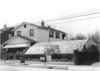
Greenhouse-like structure (plant nursery) on site by the construction of Interstate 26 (I-26). Address: 1205 King Street. Surveyor notations on back of photo: "Dkt.: 10.503. Property owner: Gladys Hardy. Tract: 18. Station: 5895+50 on CL. Date: Feb. 19, 1963. In R/W - Bought." [See collection description for explanation of surveyor notations.]
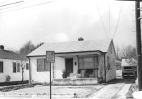
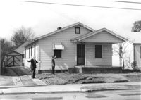
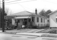
House on site by the construction of Interstate 26 (I-26). Address: 1201 King Street. Surveyor notations on back of photo: "Dkt.: 10.503. Property owner: Gladys Hardy. Tract: 18. Station: 5895+65 Rt. Date: Feb. 19, 1963. In R/W - Bought." [See collection description for explanation of surveyor notations.]
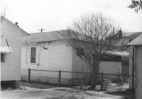
House (corner view, rear) on site by the construction of Interstate 26 (I-26). Address: 1201 King Street. Surveyor notations on back of photo: "Dkt.: 10.503. Property owner: Gladys Hardy. Tract: 18. Station: 5895+65 Rt. Date: Feb. 19, 1963. In R/W - Bought." [See collection description for explanation of surveyor notations.]
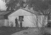
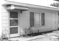
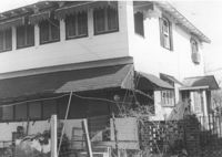
Backyard and structure on site affected by the construction of Interstate 26 (I-26). Address: 1201 King Street. Surveyor notations on back of photo: "Dkt.: 10.503. Property owner: Gladys Hardy. Tract: 18. Station: 5895+00 Rt. Date: Feb. 19, 1963. In R/W - Bought." [See collection description for explanation of surveyor notations.]
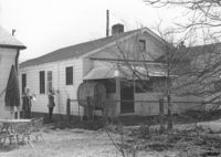
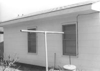
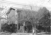
House (rear view) and backyard garden on site affected by the construction of Interstate 26 (I-26). Address: 1199 King Street. Surveyor notations on back of photo: "Dkt.: 10.503. Property owner: Nancy J. Wandell. Tract: 19. Station: 5895+85 Rt. Date: Feb. 19, 1963." [See collection description for explanation of surveyor notations.]
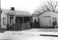
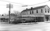
Corner of Meeting Street and Cooper Street. Charleston Auto Sales (510 Meeting Street) and Infinger's Shoe Store (508 Meeting Street), on site affected by the construction of the Crosstown. Surveyor notations on back of photo: "Dkt.: 10.518. Property owner: Robert L. Knoth. Tract: 14. Station: 5962+85 CL of Line 3 of the S.B. lane of Route 17. Date: Mar. 6, 1963. In R/W - Bought. [See collection description for explanation of surveyor notations.]
House on site affected by the construction of Interstate 26 (I-26). Address: 1199 King Street. Surveyor notations on back of photo: "Dkt.: 10.503. Property owner: Nancy J. Wandell. Tract: 19. Station: 5895+85 Rt. Date: Feb. 19, 1963." [See collection description for explanation of surveyor notations.]
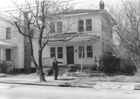
House on site affected by the construction of Interstate 26 (I-26). Address: 1197 King Street. Surveyor notations on back of photo: "Dkt.: 10.503. Property owner: Katherine A. Singleton. Tract: 20. Station: 5896+15 Rt. Date: Feb. 19, 1963. Proximity." [See collection description for explanation of surveyor notations.]