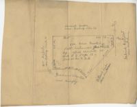
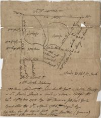
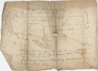
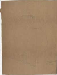
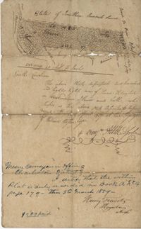
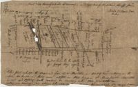
Plat of 500 acres granted to Robert Cahousac January 10,1771. Names associated with this plat are Robert Cahousac, Samuel Cooper, Gabriel Gigneliat [?], Mitchum, Witten, Zachariah Villeponteux, William Mazyck, Juxbury Lumber Co, William Washington, and Charles Parker. Notable geographic locations include St. Bartholomew's Parish and Charleston County.
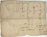
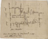
200 acres laid out to Joan Gryce, on the northwest side of Keywaw [Kiawah] Creek in Colleton County, on the left side it is bordered by the Marshes of Bohicket Creek. Names associated with this plat are Joan Gryce and James Witter. Notable geographic locations include Johns Island, Keywaw [Kiawah] Creek, and Bohicket Creek.
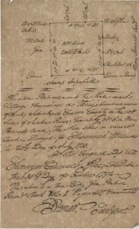
Plat contains 211 acres copied from a release form annexed to Nathaniel Broughton to Alexander Broughton. Part of Mulberry Tract. Names associated with this plat are William John Broughton, Nathaniel Broughton, Alexander Broughton and A. Domini. Notable geographic locations include Doken Creek, The Farm, St. John's Parish and Long Branch Creek.
Plat of 300 acres in Berkeley County. Very little detail included in the plat. Names associated with this plat are James McKelvey, John Evans and Sarah Vance. Notable geographic locations include Berkeley County and Russells Creek.
Plan of a tract of land belonging to George Chisolm. Names associated with this plat are George Chisolm, John Scott, A. Andrew, Thomas Hollingsby [?], and Thomas. Notable geographic locations include the Ashley River and Kuskawah [Kushiwah] Creek.
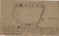
Plat of 1126 acres in St. James Goose Creek on Wasamasaw [Wassamassaw] Swamp. Plat is in pencil and is difficult to read the few details, although there are a few outlines of buildings included, but difficult to tell what they are. Names associated with this plat include Daniel Gelyer, J. Ferrels, Thomas Cusack [?], and James Haney. Notable geographic locations include Wasamasaw [Wassamassaw] Swamp, Sheep Island, Goose Creek, Road to Dorchester, and Ekells Branch.
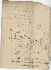
319 acre plot of land situated on Ocean Bay in St. James Parish, part of the "Hodge Grant," shows some land details like creeks and cypress ponds. Names associated with this plat are T. Hataway, Hodge, W.B. Guerard, Benjamin Fort, B.P. Colburn, Hiram Hodge , R.J. Morrison and W.H. Mellard. Notable geographic locations include Ocean Bay, St. James Parish and Santee.
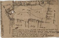
Plat of land along the Combahee River containing 5567 acres laid out for Daniel Doiley. Names associated with this plat are Daniel Doiley, Smith, Gordon Garrett, and Philips. Notable geographic locations include the Combahee River, Prince William's Parish and Farr Bluff.
General Cutherbert's land on Big Pipe Creek. Names associated with this plat are General Cuthbert, B.H. Roberts, Ball, Peters and David DeSapah [?]. Notable geographic locations include the Savannah River.
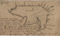
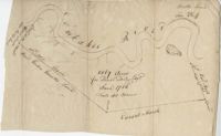
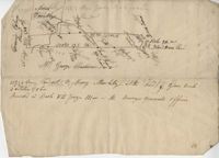
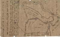
Plan of lands at Bee Creek belonging to Mr. James Bolen called Gray's Hill. Names associated with this plat include James Bolen. Notable geographic locations include St. Lukes Parish, Gray's Hill, Grey's Hill Landing, Bees Creek, and Purrysburgh.
Plat consists of 100 3/4 acres. Names associated with this plat include William Walter, William Kittlebum, Coachman, Thomas Hamilton, Benjamin, Richard and Allen. Notable geographic locations include St. George Parish and Cypress.
Plat consists of 900 acres. Names associated with this plat include Rero A. Stoble, James Bullock and H. Bryan. Notable geographic locations include Savannah and St. Peter's Parish.
300 acres of land belonging to Richard Downes at Stono. Names associated with this plat include Richard Downes, Edmond Bellinger, Thomas Mellichamp, Christopher Welkin and Archibald Stanyarn.
83 acre parcel of land that shows the land belonging to the estate of William Williamson, shows rice fields, swamp in woods, public drains, and roads. Names associated with this plat are William Williamson, George Haigery, and James Parsons. Notable geographic locations include the Stono River and Wenners.
Plat of 419 acres near Goose Creek sold to Benjamin Wood by John Parker. Only the trees located on the property line and names on neighboring property owners are included. Names associated with this plat are John Parker, Benjamin Wood, Thomas Barker, John Barley, James Boswood, Benjamin Woods, John Stevens, Thomas Hodson, I. Drayton, Thomas Mell, and Ben Godin.
Copy of a plat of 500 acres originally laid out to John Smith, now (1805) belonging to Alexander Bower as nephew and heir to the grantee. Details include swamps, surrounding lands, and trees. Names associated with this plat are Alexander Bower, John Smith, F. Bremar, William Moultrie, Sarah Blakeway, William Cattle, and Henry Crum.
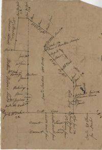
960 acres of land situated lying and being in Colleton County, butting and bounding to the north on part of John Seabrook's land to the east on Ashepoo River to the South on land of Captain Thomas Flemming and part of John Dears’ Land. Names associated with this plat are Benjamin Whitaker, Thomas Pinckney, Captain Thomas Flemming, John Seabrook, John Dear, Richard Woodward, John Hutchinson, John Godfrey, Samuel Larrington, James St. John, Godfrey, Elizabeth Woodward, William McPherson, Thomas M. Pinckney, and James M. Pinckney. Notable geographic locations are Ashepoo River, Dear's Creek and Colleton County.
Copy of plat granted to John Atchison. "The plat annexed to the grant dated March 2, 1736." Names associated with this plat are John Atchison, James St. John, Thomas Broughton, J. Branch and Middleton. Notable geographic locations include Santee, Four Mile Creek, Santee River, and Cravens County [now in parts of Berkeley, Charleston, Georgetown, and Williamsburg counties].
77 acres of marsh in two pieces situated on Johns Island along Stono River. Names associated with this plat are J.N. Mainville, Thomas Simmons, James Nicholas, Guervin, William Simmons and Marshall. Notable geographic locations are the Stono River, Johns Island, Charleston District, and Marshalls Creek.
Copy of Plat of 157 acres of land laid out to Harrison on Wadmalaw Island at the head of Wadmalaw River. Names associated with this plat are Christopher Harrison, Henry Walkins, and Luna Williams.
Plat of land laid out to Huggins of 58 acres situated on the NE side of Pee Dee River butting and bounding to the North on William Alston's land and to the south and southwest on unknown land. Names associated with this plat are Huggins, William Alston, Job Roshmahler and John Hardwick.
Plat includes 500 acres on the Cypress Swamp. Names associated with this plat are James Sanders, Matthew Nelson, William Abraham, Abraham Sanders, and Samuel Sanders. Notable geographic locations include St George’s Parish, Cypress Swamp, Dorchester, and Thorntree Swamp.
A quarter of an acre including a church on Marsh Field Plantation. Names associated with this plat are Thully T.G. Beneyor, Frederick Smith, J.G. Sturly, Rebecca Bennett and Rantowle. Notable geographic locations include St. Andrews Parish, Marsh Field Plantation, and Road to Rantowle's Ranch.
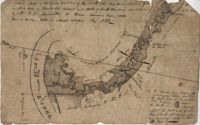
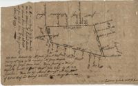
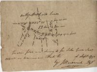
"This tract was conveyed by G. Anson Esquire thro his attorney, and Richard Lambton to Thomas Rivers February 15th 1775 and from said J. Rivers to Benj. Guerad Esquire October 7th 1779." 371 Acres laid out by William James January 21th 1774 by the request of William George Roupell attorney for Georg Anson Esquire Being part of a barony originally granted to Robert Wright [illegible] Esquire by the Lords Proprietors. [illegible] now by Ansons Barony and being part of Lot N 11 of said Barony situated near May River." Plat contains identification of a path and waterways but no structural information. Names associated with this plat include G. Anson, Richard Lambton, Thomas Rivers, Benjamin Guerad, George Roupell, Robert Wright, the Lords Proprietors and Hodgson. Notable geographic locations include St. Lukes Parish, May River and Anson's Barony.
Two small plats of land. One containing 200 acres of land laid out to Margaret Childs situated near the head of Weetee Branch. Bounding on the NE, NW, and SE, and West on vacant lands. Southwestardly on land formerly laid out to Daniel Gibbons. The second plat is 78 acres of land laid out to Robert Newman in Craven County bounding to the north of Orochone [?] and on all other sides by vacant land. Names associated with this plat are Daniel Gibbons, Robert Newman, James St. John, Thomas Broughton, and Margaret Childs. Notable geographic locations include Prince Frederick’s Parish, Georgetown district, Weetee River, and Christal [Crystal?] Spring.
Copy of two plats: 1) 300 acres conveyed by Thomas Lynch to William Moultrie April 1, 1762, afterwards conveyed by Moultrie to Benjamin Singleton 2) 53 acres conveyed by Francis Kinloch to William Moultrie on the 8th February, 1765 now belonging to Benjamin Singleton. Names associated with this plat are Thomas Lynch, William Moultrie, Benjamin Singleton, Francis Kinloch, and Manigault. Notable geographic locations include Santee, White Oak, Six Mile Creek, and the Santee River.
Plat of 288 acres of land situated on Wadmalaw Island. Names associated with this plat are William Weston, Jonathan Runnel, James Clarks, Benjamin Allston [?], and Henry Treads. Notable geographic locations include Wadmalaw River, Wadmalaw Island, Bain Bluff, and Charleston District.
"Copy of a plat of a tract now belonging to Richard Goughlr." The tract contains 500 acres and states that it was granted to Isaac Lewis on March 21, 1715. Names associated with this plat are Isaac Lewis, John Broughton, John Glover, John Diamond, and Richard Goughlr [?]. Notable geographic locations include Goose Creek, St. James Parish and Black Jon Bay.
Plan of approximately 1500 acres on Black River near Georgetown part now belonging to Kinloch and Gadsden. Names associated with this plat are Gadsden, Kinloch, Alston, Thomas Gadsden, James Lloyd, and Morreau [?] Sarrazin.
Copy of a plat annexed to the original grant for 1153 acres of land to Thomas Farr lettered A-E. Names associated with this plat are Daniel Green, Thomas Farr, Elizabeth Gibbs, Christopher Wilkinson, Joseph Smith, Andrew Smith, Thomas Smith, George Haig, Joseph Farr, Humphrey Sommers, and Benjamin Stoney.
156 acres laid out to John Bayly and granted to the said John Bayly in 1698 in Colleton County. Names associated with this plat are George Mitchell, John Bayly, and John Andrews.
100 square plot sold by Beauford, Boggy Gully runs through the southwest corner of the property. Names associated with this plat are William Byrd Beauford and J.B. Johnson.
Plat of 230 acres on Johns Island. Little detail included on the plat, but there is an short explanation of the deed. Names associated with this plat are John Jones, Ebenezer Simmons, James Witter, Samuel Palmevine, John Palmavin, and Welkins. Notable geographic locations included in this plat are the Keiwaugh [Kiawah] River, Coll’s Creek, Savannah Tract, Johns Island, and Colleton County.
Plan of a parcel of land situated on Johns Island and containing 86 1/2 acres. Being part of a body of land belonging to Thomas Mathews. Bounded northwardly by a public road, eastwardly on James Legare's land, and southwardly on land belonging to Isaac Holmes and Thomas Legare. Intended to be conveyed to Isaac Holmes. Names associated with this plat are Thomas Mathews, Isaac Holmes, Thomas Legare, William Stanyarn, Matthews and James Legare.
Two plats of lands along the Savannah River belonging to Stobo and Bullock. Names associated with this plat are Archibald Stobo, James Stobo, James Bullock, W. Hugh Bryan, Clawton [?], Cranford, J. Southerland, and Patrick Mikas. Notable geographic locations include the Savannah River, St. Peter's Parish and Purrysburgh Township.
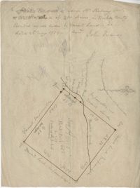
222 acres sold by Archibald Stanyarn to Andrew Down in 1772. Reverse side includes notes on various conveyances. Names associated with this plat are Archibald Stanyarn, Andrew Down, J. Williamson, Edmond Bellizer, Thomas Cliffon, Kewn [?], David Joomer [?] and Henry. Notable geographic locations include Colleton County and Stono River.
Copy of a plat part now belonging to Benjamin Perry and part to John Pringle on the west side of Ashley River. Names associated with this plat include John Pringle, Benjamin Perry, John Julius Pringle, Lambert Lance, Abraham Ladson, Sarah Rose, Nathaniel Bradwell, Ephraim Mitchell, Thomas Drayton, John Frazer, Frances Baker, Thomas Osborn, Isaac Landson, Isaac Perry, John Drayton, Glen Drayton, Francis Ladson and W. John Cattle. Notable geographic locations include the Ashley River, Charleston, Berkeley County, and Ashley River Road.
Plat and abstracts of deeds belonging to James Laurence. Names associated with this plat include James Laurence, John Heyward, John Cole, Hogg, Loalan, Samuel Forsythe, William Forsythe, J. Schreiber, Henry Laurence, Harrison, Alexander Wright, Horry [?], and John Delayay.
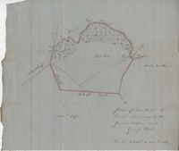
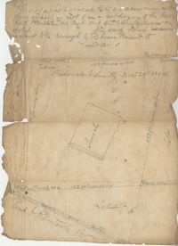
Copy of plan of a plantation on Stono Swamp commonly called Stono Plantation belonging to Thomas Ferguson. Contains 630 acres. Approximately 360 acres is swamp and approximately 270 acres is highland. Names associated with this plat are Thomas Ferguson, George Haig, Joseph Farr, Mary Williams, Smith and John McSweeney. Notable geographic locations include Stono Swamp, Stono Plantation and Charleston.
650 acres belonging to Thomas Cordes on eastwest side of Fishpond Creek/ Ashepoo River bounding northwest on Elizabeth Woodward and south by Captain John Gibbes. Names associated with this plat are Thomas Cordes, Elizabeth Woodward, Captain John Gibbes, and Robert Johnson. Notable geographic locations include Fishpond Creek, the Ashepoo River and St. Bartholomew's Parish.
600 acres plot granted to Richard Floyd residing in Colleton County lying and budding on the southside of Bohickett Creek, shows surrounding property names and creeks, shows land notes but no land type or details. Also shown is 200 acres granted by the Lords Proprietors by William Arnell in Colleton County. Names associated with this plat are Richard Floyd, Graeme [?], the Lords Proprietors, Michael Ranell, Thomas Broughton, Robert Gibbes, William Atnel, Timothy Bellemey, Anthony Matthews, Ambross Hill, John Prescot and Neufville. Notable geographic locations include John's Island, Bohickett Creek, Colleton County, Ambrose Hill, Stono River, and Keywa [Kiawah] Island.
Plat of 130 acres on the Pee Dee River. Explains the plat and the surrounding area, drawing itself has little detail. Names associated with this plat are William Swinton, Joseph LaBruce, John White, James St. John, Elias Hopkin, and Thomas [?]. Notable geographic locations include the Pee Dee River, Black River, Weehaw Plantation, Kensington Plantation, Weehaw Creek, Georgetown, and Craven County [now in parts of Berkeley, Charleston, Georgetown, and Williamsburg counties].
Plat of 210 acres belonging to William Williams surrounded by land owned by Thomas Pinckney, Christopher Smith, and Thomas Dalton. No other notes written as to the location of the land. Very little detail on the plat included. Names associated with this plat include William Williams, Thomas Pinckney, Christopher Smith, Thomas Daulton, Thomas Smith, Edward Weekly, William Dry, Ralph Izard, Charles Fields, John Jolhimns [?], Thomas Broughton, and Hannah English aka Hannah Williams.
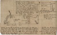
Plan of a tract of land containing 130 acres situated in Darres [Parris] Island in Beaufort. Names associated with this plat are Andrew Fitzsimons. Notable geographic locations include Beaufort, Darres [Parris] Island, and Broad River.
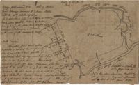
Plat of Hopewell Plantation with surrounding lands owned by several people, shows the Edisto River and an unnamed settlement, labels the land in the center as uncleared land while swamps, roads, rivers and trees surround it. Acreage unclear. Names associated with this plat are Baring, Branford, Mellechamp, Colonel W. Hayne and Arthur Middleton. Notable geographic locations are St. Paul's Parish, Edisto River, and Willtown Road.
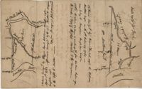
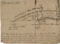
1050 Acres surveyed for William Whayman in London, shows two separate plots (No. 12 and 13), shows the River May, shows different types of trees, creeks, and swamps that run through the property. Names associated with this plat are William Whayman, William Sandy, Joseph Hodge, William Hodgson, Robert Bradsford, Robert Dee, Robert Wright, Anson, Thomas Rivers, and Rivers. Notable geographic locations include River May.