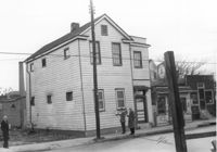
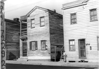
House (and neighboring buildings) on site affected by the construction of the Crosstown. Address: 60-58 Aiken Street. Public Telephone sign in foreground. Surveyor notations on back of photo: "Dkt.: 10.518. Property owner: Congaree Jenkins, Est. Tract: 54. Station: 48+00 Rt. N.B. lane Route 17. Date: Mar. 7, 1963." [See collection description for explanation of surveyor notations.]
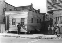
House on site affected by the construction of the Crosstown. Address: 68 Cooper Street. (Number on building is 78.) Surveyor notations on back of photo: "Dkt.: 10.518. Property owner: Ester Bosser. Tract: 42. Station: 44+65 Rt. line 9 north of Cooper Street. Date: Mar. 6, 1963. In R/W - Bought. [See collection description for explanation of surveyor notations.]
House on site affected by construction of the Crosstown. Address: 68 Cooper Street. (Number on building is 78.) Surveyor notations on back of photo: "Dkt.: 10.518. Property owner: Ester Bosser. Tract: 42. Station: 44+65 Rt. line 9 north of Cooper Street. Date: Mar. 6, 1963. In R/W - Bought. [See collection description for explanation of surveyor notations.]
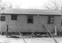
House on site affected by the construction of the Crosstown. Address: 59 Lee Street (corner of Lee Street and Hanover Street). Surveyor notations on back of photo: "Dkt.: 10.518. Property owner: Melvin Whaley. Tract: 40. Station: 44+35 Rt. S.B. lane Route 17. Date: Mar. 6, 1963. In R/W - Bought. [See collection description for explanation of surveyor notations.]
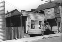
House on site affected by the construction of the Crosstown. Address: 88 Hanover Street. Surveyor notations on back of photo: "Dkt.: 10.518. Property owner: Jerusalem Baptist Church. Tract: 43. Station: 43+90 CL line 9 north of Cooper Street. Date: Mar. 6, 1963." [See collection description for explanation of surveyor notations.]
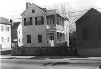
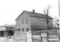
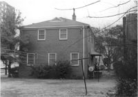
House (corner view, rear) on site affected by the construction of Interstate 26 (I-26). Address: 518½ Meeting Street. Wooden fence in foreground. Surveyor notations on back of photo: "Dkt.: 10.517. Property owner: Mrs. Bessie Rosen. Tract: 60. Station: 5959+80 CL - Line 6. Date: March 5, 1963. In R/W - Bought." [See collection description for explanation of surveyor notations.]
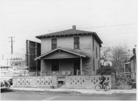
House on site affected by the construction of Interstate 26 (I-26). Address: 86 Cooper Street. Shell gas station (previous photo) in background. Surveyor notations on back of photo: "Dkt.: 10.517. Property owner: Nellie T. France. Tract: 62. Station: 5961+60 Rt. - Line 6. Date: March 5, 1963. In R/W - Bought." [See collection description for explanation of surveyor notations.]
House (rear view) on site affected by the construction of Interstate 26 (I-26). Address: 86 Cooper Street. Surveyor notations on back of photo: "Dkt.: 10.517. Property owner: Nellie T. France. Tract: 62. Station: 5961+60 Rt. - Line 6. Date: March 5, 1963. In R/W - Bought." [See collection description for explanation of surveyor notations.]
House (side view) on site affected by the construction of Interstate 26 (I-26). Address: 15 Addison Street (rear). Surveyor notations on back of photo: "Dkt.: 10.503. Property owner: Maggie Tobias. Tract: 100-A. Station: 5920+45 Lt. Date: Feb. 20, 1963. Outside R/W bought." [See collection description for explanation of surveyor notations.]
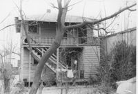
Dwelling (rear view) on site affected by the construction of Interstate 26 (I-26). Address: 39-43 Mount Pleasant Street. Surveyor notations on back of photo: "Dkt.: 10.503. Property owner: Mary Ellen Long Way. Tract: 4. Station: 5891+80 Lt. Date: Feb. 19, 1963. In R/W - Bought." [See collection description for explanation of surveyor notations.]
Right of way--South Carolina--Charleston County, Highway planning--South Carolina--Charleston County, Vernacular architecture--South Carolina--Charleston County, Lost architecture--South Carolina--Charleston County, Dwellings--South Carolina--Charleston County✖[remove]463