Copy of a plan of lots No.1-7, 9-11 on Cumberland Street in Charleston, Ward No.3. Indicates some buildings including a brick stable at No. 9 and DeBorr’s house and lot. “Lands of Mr. Edwards" is written above the lots. Names associated with this plat include De Borr, Edwards, and Charles Parker. Notable geographic locations include Church Street, Corr Alley or Philadelphia Street, Cumberland Street, and Ward Number 3.
Farm of 54 across for sale by Rutherford, individual plots lettered A-S. Names associated with this plat are Birkman, Rutledge Phokes, Fitch, Kinsman and Rutherford. Notable geographic locations include Broad Street and Dorchester Road.
Office copy of a survey of 31 acres of land for Dr. R. H. Martin in Berkeley County. Notable geographic locations include Wappoo Road and Mill Tract. Names associated with this plat are R.H. Martin, G.G. DuPont, and W.B. Guerard.
876 acres of land west of Murray Road in St. John's Parish. Names associated with this plat are Chas Johnston, Ben Castell, William Simpson, Verth, and J.G. Wiare. Notable geographic locations include Wadboo Barony.
Office copy of a tract of land once belonging to Thomas Nau then John S. Cripps containing 277 1/2 acres. The land includes gum, white and red oak, and cedar trees along with posts, a rice field and a bridge over the public road from Rantoles [Rantowles] to Charleston. Names associated with this plat include John S. Cripps, Thomas Nau, and S. Lewis.
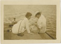
Black-and-white image depicting two women and dog on boat deck. Inscription on back of image reads, "Eulalie Lawton - left, Min McLeod - right, on the Merrimac."
Plat of land of 64 acres laid out for Allard Belin situated on Sandy Island. Names associated with this plat are Allard Berlin, John Hardwick and D.T. Waring.