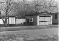
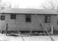
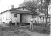
Garage and shed on site affected by the construction of Interstate 26 (I-26). Surveyor notations on back of photo: "Dkt.: 10.490. Property owner: Mostester Brown [Montester Brown?]. Tract: 87-C. Station: 5825+45 Rt. [Undated.] In R/W - Bought." [See collection description for explanation of surveyor notations.]
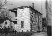
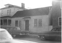
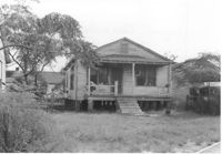
House on site affected by the construction of Interstate 26 (I-26). Possibly on Rivers Avenue. Surveyor notations on back of photo: "Dkt.: 10.486. Property owner: Ernest E. & Nolie C. Grooms. Williams Furniture Corp. Tract: 41. Station: 29+40 Lt. Date: May 30, 1961. In R/W - Bought." [See collection description for explanation of surveyor notations.]
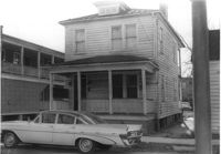
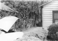
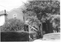
House (corner view, rear) on site affected by the construction of Interstate 26 (I-26). Possibly on Rivers Avenue. Surveyor notations on back of photo: "Dkt.: 10.486. Property owner: Mrs. Mertice S. Greenhill. Tract: 26. Station: 8+50 Lt. (Line E). Date: May 30, 1961. In R/W - Bought." [See collection description for explanation of surveyor notations.]
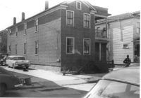
House on Sheppard Street (rear view) on site affected by the construction of the Crosstown. Address: 137 Sheppard Street. Surveyor notations on back of photo: "Dkt.: 10.524. Property owner: Frank Williams. Tract: 126. Station: 89+40 Lt. Date: Dec. 2, 1964. In R/W - Bought." [See collection description for explanation of surveyor notations.]
House on Sheppard Street on site affected by the construction of the Crosstown. Address: 135 Sheppard Street. Surveyor notations on back of photo: "Dkt.: 10.524. Property owner: William Delestine, et al. Tract: 127. Station: 89+80 CL. Date: Dec. 2, 1964. In R/W - Bought." [See collection description for explanation of surveyor notations.]
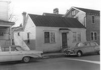
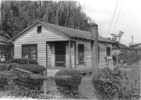
House on site affected by the construction of the Crosstown. Address: 139 Sheppard Street. Surveyor notations on back of photo: "Dkt.: 10.524. Property owner: Wilmot J. Frasier. Tract: 125. Station: 89+15 Lt. Date: Dec. 2, 1964. In R/W - Bought." [See collection description for explanation of surveyor notations.]
House on site affected by the construction of the Crosstown. Address: 139 Sheppard Street. Surveyor notations on back of photo: "Dkt.: 10.524. Property owner: Wilmot J. Frasier. Tract: 125. Station: 89+15 Lt. Date: Dec. 2, 1964. In R/W - Bought." [See collection description for explanation of surveyor notations.]
House on Sheppard Street on site affected by the construction of the Crosstown. Address: 137 Sheppard Street. Surveyor notations on back of photo: "Dkt.: 10.524. Property owner: Frank Williams. Tract: 126. Station: 89+40 Lt. Date: Dec. 2, 1964. In R/W - Bought." [See collection description for explanation of surveyor notations.]
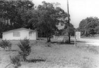
Lot and house (side view) on site affected by the widening of U.S. Route 17. Posted sign says: Edna's Ceramic Chop: Greenware, supplies, firing, lessons. Presumably located in Mount Pleasant or vicinity. Surveyor notations on back of photo: "Dkt.: 10.439. Property owner: Doretha B. Chavis. Tract: 15. Station: 224+51 to 225+51 Lt. Date: Jul. 22, 1965. Proximity." [See collection description for explanation of surveyor notations.]
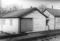
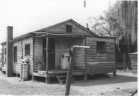
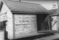
Shed (railroad building) along railroad tracks, on site affected by the construction of Interstate 26 (I-26). Address: 19½ Poinsett Street (rear). Surveyor notations on back of photo: "Dkt.: 10.503. Property owner: S.A.L.R.R. Tract: 105. Station: 5924+35 Rt. & Lt. Date: Feb. 20, 1963." [See collection description for explanation of surveyor notations.]
House (side view) on site affected by the construction of Interstate 26 (I-26). Address: 15 Addison Street (rear). Surveyor notations on back of photo: "Dkt.: 10.503. Property owner: Maggie Tobias. Tract: 100-A. Station: 5920+45 Lt. Date: Feb. 20, 1963. Outside R/W bought." [See collection description for explanation of surveyor notations.]
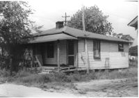
House on site affected by the construction of Interstate 26 (I-26). Building address number 208. Surveyor notations on back of photo: "Dkt.: 10.490. Property owner: Cora L. Gantt, et al. Tract: 65. Station: 5802+90 Lt. Line 'F'. Date: September 12, 1962. In R/W - Bought." [See collection description for explanation of surveyor notations.]
House (rear view) on site affected by the construction of Interstate 26 (I-26). Surveyor notations on back of photo: "Dkt.: 10.490. Property owner: E.S. Lapine, et al. Tract: 60. Station: 5801+40 Rt. Line 'G'. Date: September 12, 1962. In R/W - Bought." [See collection description for explanation of surveyor notations.]
House (rear view) on site affected by the construction of Interstate 26 (I-26). Surveyor notations on back of photo: "Dkt.: 10.490. Property owner: Leah D. Governor. Tract: 58. Station: 5800+70 Lt. Line 'G'. Date: September 12, 1962. In R/W - Bought." [See collection description for explanation of surveyor notations.]
House (rear view) on site affected by the construction of Interstate 26 (I-26). Surveyor notations on back of photo: "Dkt.: 10.490. Property owner: F.F. Bellinger, et al. Tract: 61. Station: 5801+20 Rt. Line 'G'. Date: September 12, 1962. Proximity." [See collection description for explanation of surveyor notations.]
House and structures on site affected by the construction of Interstate 26 (I-26). Surveyor notations on back of photo: "Dkt.: 10.490. Property owner: E.S. Lapine, et al. Tract: 59. Station: 5800+80 Rt. Line 'G'. Date: September 12, 1962. In R/W - Bought." [See collection description for explanation of surveyor notations.]
House on site affected by the construction of Interstate 26 (I-26). Surveyor notations on back of photo: "Dkt.: 10.490. Property owner: Leah D. Governor. Tract: 58. Station: 5800+70 Lt. Line 'G'. Date: September 12, 1962. In R/W - Bought." [See collection description for explanation of surveyor notations.]
Shed (railroad building) on site affected by the construction of Interstate 26 (I-26). Address: 19½ Poinsett Street (rear). Surveyor notations on back of photo: "Dkt.: 10.503. Property owner: S.A.L.R.R. Tract: 105. Station: 5924+25 Rt. Date: Feb. 20, 1963." [See collection description for explanation of surveyor notations.]
Shed (railroad building) along railroad tracks, on site affected by the construction of Interstate 26 (I-26). Address: 19½ Poinsett Street (rear). Surveyor notations on back of photo: "Dkt.: 10.503. Property owner: S.A.L.R.R. Tract: 105. Station: 5924+40 Lt. Date: Feb. 20, 1963." [See collection description for explanation of surveyor notations.]
House (side view, rear) on site affected by the construction of Interstate 26 (I-26). Address: 1 Carolina Street. Surveyor notations on back of photo: "Dkt.: 10.517. Property owner: Ella W. Britton. Tract: 130. Station: 21+30 Lt. and Rt. (Line "1"). Date: November 4, 1965. Side and rear view of residence and lot, all entirely in R/W." [See collection description for explanation of surveyor notations.]