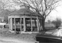
Gazebo, on site affected by the widening of Route 171 (Folly Road). Surveyor notations on back of photo: "Dkt.: 10.494. Property owner: Sophie Sabel, Est. Tract: 97. Station: 370+50 Lt. Date: Mar. 21, 1962. In R/W - Bought. [See collection description for explanation of surveyor notations.]
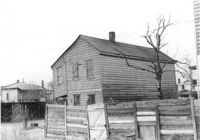
House (corner view, rear) on site affected by the construction of Interstate 26 (I-26). Address: 518½ Meeting Street. Wooden fence in foreground. Surveyor notations on back of photo: "Dkt.: 10.517. Property owner: Mrs. Bessie Rosen. Tract: 60. Station: 5959+80 CL - Line 6. Date: March 5, 1963. In R/W - Bought." [See collection description for explanation of surveyor notations.]
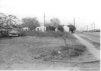
Lot on Spruill Avenue, on site affected by the construction of Interstate 26 (I-26). Houses in background. Surveyor notations on back of photo: "Dkt.: 10.490. Property owner: E.C. Brown. Tract: 28-A. Station: 51+50 Rt. (Spruill Ave.). Date: November 4, 1965. General view of land located in radius at intersection of Spruill Ave. and I-26. Line 'A'." [See collection description for explanation of surveyor notations.]
House on site affected by the construction of Interstate 26 (I-26). Building address number 22 (painted on mailbox). Surveyor notations on back of photo: "Dkt.: 10.471. Property owner: Eleanor L. O'Brien. Tract: 105. Station: 5379+50 Lt. Date: Aug. 23, 1960. Proximity." [See collection description for explanation of surveyor notations.]
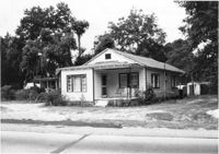
House on site affected by the widening of U.S. Route 17. Presumably located in Mount Pleasant or vicinity. Surveyor notations on back of photo: "Dkt.: 10.597. Property owner: Julia B. Simmons. Tract: 54. Station: 301+00 Lt. Date: Sept. 17, 1968." [See collection description for explanation of surveyor notations.]
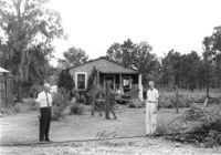
House, and Fuller's Grocery, on site affected by the construction of Interstate 26 (I-26). Surveyor notations on back of photo: "Dkt.: 10.471. Property owner: H.L. Fuller. Tract: 103. Station: 28+00 Lt. (Midland Park Road). Date: Aug. 23, 1960. Proximity." [See collection description for explanation of surveyor notations.]
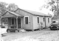
House on site affected by the construction of Interstate 26 (I-26). Surveyor notations on back of photo: "Dkt.: 10.471. Property owner: Katie S. Smith. Tract: 37. Station: 5323+80 Lt. Date: Aug. 23, 1960. In R/W - Bought." [See collection description for explanation of surveyor notations.]
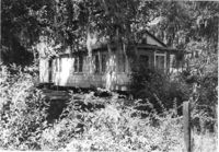
House on site affected by the construction of Interstate 26 (I-26). Surveyor notations on back of photo: "Dkt.: 10.471. Property owner: Mamie W. Brown. Tract: 91. Station: 5376+15 Rt. Date: Aug. 23, 1960. In R/W - Bought." [See collection description for explanation of surveyor notations.]
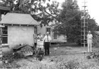
House on site affected by the construction of Interstate 26 (I-26). Surveyor notations on back of photo: "Dkt.: 10.471. Property owner: M.L. Shipman, et al. Tract: 42. Station: 5326+75 Rt. Date: Aug. 23, 1960. Proximity." [See collection description for explanation of surveyor notations.]
House on site affected by the construction of Interstate 26 (I-26). Surveyor notations on back of photo: "Dkt.: 10.471. Property owner: W.W. Gregory. Tract: 46. Station: 5329+60 Rt. Date: Aug. 23, 1960. Proximity." [See collection description for explanation of surveyor notations.]