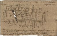
Copy of a plan of lots No.1-7, 9-11 on Cumberland Street in Charleston, Ward No.3. Indicates some buildings including a brick stable at No. 9 and DeBorr’s house and lot. “Lands of Mr. Edwards" is written above the lots. Names associated with this plat include De Borr, Edwards, and Charles Parker. Notable geographic locations include Church Street, Corr Alley or Philadelphia Street, Cumberland Street, and Ward Number 3.
Farm of 54 across for sale by Rutherford, individual plots lettered A-S. Names associated with this plat are Birkman, Rutledge Phokes, Fitch, Kinsman and Rutherford. Notable geographic locations include Broad Street and Dorchester Road.
Office copy of a survey of 31 acres of land for Dr. R. H. Martin in Berkeley County. Notable geographic locations include Wappoo Road and Mill Tract. Names associated with this plat are R.H. Martin, G.G. DuPont, and W.B. Guerard.
876 acres of land west of Murray Road in St. John's Parish. Names associated with this plat are Chas Johnston, Ben Castell, William Simpson, Verth, and J.G. Wiare. Notable geographic locations include Wadboo Barony.
Office copy of a tract of land once belonging to Thomas Nau then John S. Cripps containing 277 1/2 acres. The land includes gum, white and red oak, and cedar trees along with posts, a rice field and a bridge over the public road from Rantoles [Rantowles] to Charleston. Names associated with this plat include John S. Cripps, Thomas Nau, and S. Lewis.
Plat of land of 64 acres laid out for Allard Belin situated on Sandy Island. Names associated with this plat are Allard Berlin, John Hardwick and D.T. Waring.
Copy of plan of a plantation on Stono Swamp commonly called Stono Plantation belonging to Thomas Ferguson. Contains 630 acres. Approximately 360 acres is swamp and approximately 270 acres is highland. Names associated with this plat are Thomas Ferguson, George Haig, Joseph Farr, Mary Williams, Smith and John McSweeney. Notable geographic locations include Stono Swamp, Stono Plantation and Charleston.
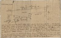
3.71 Acres of highland near marsh adjacent to Meeting Street Road. Names associated with this plat are Karl W. Ruth, A.F.C. Kramer, and S. Louis Simons.
Copy of tract of land containing 200 acres, butting and bounding south and west by William Elliott, and on the east by Clay, and to the north by John Rivers. Names associated with this plat include William Webb, Thomas Mellichamp, Butler, William Elliott, William Clay, Shem, John Rivers, John S. Cripps, Samuel Jones, the Lords Proprietors, and Daniel Gibson.
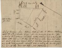
58 acres of land laid out unto M. Belin situated on Sandy Island. Names associated with this plat are John Hardwick, Thomas Waring, Broughton and Postell.
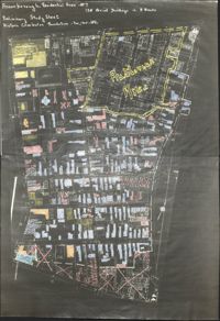
Six maps conveying plans to beautify Ansonborough, showing the footprints of buildings and annotated to indicate the status of buildings, traffic flow, and scenarios that would result from the Ansonborough Rehabilitation Project.
Hand-drawn and color-coded map of Ansonborough indicating properties purchased by HCF, restored by HCF, for sale by HCF, restored privately, and other distinctive antebellum houses. Created to illustrate HCF’s Ansonborough Rehabilitation Project.
Map of Ansonborough showing Meeting Street, King Street, Hasell Street, Maiden Street, Old Church Street, Bay Street, and others. A small piece of paper taped to the back reads: "Kindness of: Mr. Gedney M. Howe."
Copies of Sanborn Map pages combined to study maps of various areas in Charleston. Color-coded to depict building status. Second image provides key for color coding.
Page 243 of the City Engineer's Plat Book with three plats. Plat 1 features lots along Cumberland Street, near where it intersects with State Street. The second plat features "City Lands West of President Street and South of Congress Street." It also labels reading "Old Folks Holme," "Grave Yard Old Folks Home," "City Board of Public School Commissioners," and "Colored Industrial School." Plat 3 shows lots located west of Meeting Street, and also shows Cooper Street, Lee Street, Sheppard Street, and Sumter Street.
Page 244 of the City Engineer's Plat Book with three plats. Plat 1 shows lots and structures located along Maple Street, near where it intersects with Meeting Street. Plat 2 features a lot located on the east side of Tenth Street, between St. Margaret Street and Grove Street. Plat 3 shows land located near the intersection of State Street and Cumberland Street.
Page 246 of the City Engineer's Plat Book with one plat. The plat shows lots located between Rutledge Avenue and the Ashley River. Groups of lots are labelled with red letters. The plat also shows Darlington Avenue, Ashley Avenue, Piedmont Avenue, Hester Street, Clemson Street, Maple Street, Peachtree Street, Poplar Street, Pendleton Street, and Sans Souci Street.
Page 251 of the City Engineer's Plat Book with two plats. Plat 1 shows Meeting Street, Williman Street, and Romney Street. Plat 2 shows lots located on and near America Street, Lee Street, Cooper Street, and Drake Street.
Page 257 of the City Engineer's Plat Book with two plats. Plat 1 shows lots located between St. Margaret Street and Grove Street. Plat 2 shows lots located along Marsh Street and Concord Street, near where they intersect with Laurens Street.